A cool moist autumn in 2020

The daily weather log

[Note.
Due to illness, 45 days of this season, from 23rd March to 7th May, were missed for some Manilla values. No values were noted for cloud or soil temperature; mean values shown for the season are estimates only. Missed values of daily maximum and minimum air temperatures were estimated by regression on values from Tamworth Airport Automatic Weather Service.]

Instead of warm spells as in autumn 2019, this season had several cool spells. Three or four had cool days, but one in mid-march had cooler nights. Cool days in late May came with a very narrow daily temperature range, high humidity and cloud.
There were 18 rain days (normally 14) spread through the season, with the highest reading (20.0 mm) on the 1st of May.
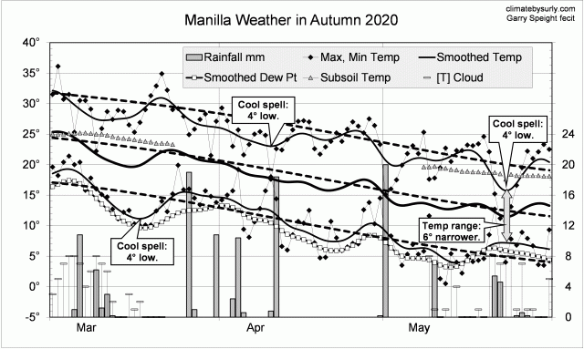
Weather log autumn 2020

Comparing autumn seasons

In contrast to the previous two autumn seasons, autumn 2020 was cool and moist. Days (24.4 deg) were 2nd coolest for autumn in the new century (after 2003). Night temperatures were normal, and the mean one degree low.
The rainfall total, 124 mm, was at the 55th percentile, not far below the mean of 134 mm. Other moisture measures were higher: early morning dew point was 9.0 deg, cloudiness 41%, and daily temperature range 13.8 deg.

Climate for autumn 2020


Data. The Bureau of Meteorology automatic rain gauge, Manilla Museum, Station 55312, recorded no readings from 24th February 2020 until 11th March 2020. I used my own readings for that period. Readings later in autumn are from the Manilla (Museum) gauge.

My estimates of early morning dew point have become anomalously low. From 1 August 2019, I use values taken from Tamworth Airport graphs at the time of minimum temperature.
All other data, including subsoil at 750 mm, are from 3 Monash Street, Manilla.

2019-20 summer hot and moist

Sef-sown senna plants

Pepper-leaf Senna

Through December and January, this summer had a series of heat waves perhaps worse than those of the previous two summers, and rainfall and humidity were low. Similar droughty weather elsewhere brought catastrophic bushfires.
On the 3rd of February the weather changed dramatically. Heat waves were replaced by spells of cool or normal temperature, with high humidity, overcast days, and rain. Up to that date, cool spells had not occurred since November 2018, 15 months earlier. During those 15 months, regardless of the season, the weekly mean temperature often rose several degrees above normal, but never fell below normal.
Coincidentally, there were 14 rain days in both the hot-dry part of the season (65 days) and in the cool-wet part (26 days).

Weather log summer 2019-20

Seasonal average or total figures for this summer mean little because of the climatic break from 3 February.
Mean temperatures (max, mean, min) were close to the records set in the summers of 2017 and 2019, which they would have exceeded if February had not become cooler. Subsoil temperature remained normal.
In summer 2018-19, two of the moisture measures (daily temperature range and cloudiness) had been near normal, while rainfall and dew point had been low. Now, in 2019-20, rainfall and dew point were higher, making all four moisture measures normal.
The summer rainfall total of 232 mm is at the 55th percentile, very close to the average (227 mm).

Manilla summer climate


Data. A Bureau of Meteorology automatic rain gauge operates in the museum yard. From 17 March 2017, 9 am daily readings are published as Manilla Museum, Station 55312.  These reports use that rainfall data when it is available. I have used it since 20 July, when the Museum gauge began recording again.  Unfortunately, the gauge failed during this season (25/02/2020 ). Pending repair, I am using my own gauge. My estimates of early morning dew point have become anomalously low. From 1 August 2019, I use values taken from Tamworth Airport graphs at the time of minimum temperature.
All other data, including subsoil at 750 mm, are from 3 Monash Street, Manilla.

Spring 2019 hot and very dry

Blooming senna bush

Senna coronilloides

Spring was marked by a succession of warm and cool spells. Nights varied around the normal seasonal temperature but days had no spells cooler than normal. A hot spell late in November had days 6° above normal as a weekly average. The dew point showed very dry air in mid-November.
There were nine rain days, as in the droughty spring of 2002. The highest reading was 16.6 mm. Rainy and cloudy days came about every three weeks.

Weather log spring 2019

The hot dry climate this spring was very like that of 2014, and quite unlike the cool wet climate of 2016.
Days, averaging 29.0°, were hotter than in any spring except 2002 (29.2°). Nights, at 11.2°, were only half a degree above average. (The winter of 2019 had a similar pattern.)
Dryness was shown by very little morning cloud (21%), very low early-morning dew point (3.7°) and very wide daily temperature range (17.8°).
The total rainfall of 62.4 mm makes this the fourth driest spring, after 1957 (23 mm), 1944 (40 mm), and 1951 (54 mm).

Climate spring 2019


Data. A Bureau of Meteorology automatic rain gauge operates in the museum yard. From 17 March 2017, 9 am daily readings are published as Manilla Museum, Station 55312.  These reports use that rainfall data when it is available. I have used it since 20 July, when the Museum gauge began recording again. My estimates of early morning dew point have become anomalously low. From 1 August 2019, I use values taken from Tamworth Airport graphs at the time of minimum temperature.
All other data, including subsoil at 750 mm, are from 3 Monash Street, Manilla.

Winter 2019 lowest rainfall?

White box eucalyptus tree

White Box Tree

There were several warm spells, mainly as warm days. The warmest was in early July, when days were 4.2° high and nights 4.0°. The only unusual daily temperatures were one high maximum of 27.1° and one low maximum of 11.3° in July.

There were 41 frosts, normally 44.
As in the drought year of 2002, there were only 8 rain days. The highest reading (estimated) was only 5.5 mm on 9 July.

Weather log winter 2019

This winter had the warmest days of the new century (19.5°) but nights that were near normal (3.2°).
Apart from the extremely low rainfall, the other moisture indicators (little cloud, low dew point, wide daily temperature range) were not as severe as in winter 2018.
The total rainfall of 20.9 mm is the 2nd lowest on record for winter. However, it may actually be the lowest. Although the year 1888 had recorded winter rainfall of only 6 mm, there is doubt about that. Daily readings are missing for June and July. The next lowest was 1946, with 29 mm, then 1972 and 1982, both with 32 mm.

winter climate 2019


Data. A Bureau of Meteorology automatic rain gauge operates in the museum yard. From 17 March 2017, 9 am daily readings are published as Manilla Museum, Station 55312.  These reports use that rainfall data when it is available. In this season, I used my own readings until 20 July, when the Museum gauge began recording again. My estimates of early morning dew point have become anomalously low. From 1 August 2019, I use values taken from Tamworth Airport graphs at the time of minimum temperature.
All other data, including subsoil at 750 mm, are from 3 Monash Street, Manilla.

Another warm autumn, 2019

Lake Keepit very low

Keepit Dam at 0.9%

This season had a series of warm spells separated by normal autumn temperatures. The warmest, about 4° above normal, came in early March, late April and late May. Dry air came at cooler times, near the 1st of March and the 12th of April. Most of the rain came in two very wet days: the 30th of March and the 4th of May (61 mm).

Weather log autumn 2019

Comparing autumn seasons

As in 2018 and 2016, autumn was very warm. Although autumn 2016 had the highest mean temperature of the new century, this autumn had the warmest nights: 12.7°.
Despite the on-going drought, measures of moisture were near normal for the season. Cloudy days reached 37%, the daily temperature range (14.3°) was quite narrow, and the early morning dew point (7.2°) not low. The rainfall total, 117 mm (est.), was at the median value, not far below the mean of 134 mm.

Manilla clmate for autumn


Data. A Bureau of Meteorology automatic rain gauge operates in the museum yard. From 17 March 2017, 9 am daily readings are published as Manilla Museum, Station 55312.  These reports use that rainfall data when it is available. Station 55312 recorded no readings this autumn. I used my own readings for the whole season.

All other data, including subsoil at 750 mm, are from 3 Monash Street, Manilla.