A cool moist autumn in 2020

The daily weather log

[Note.
Due to illness, 45 days of this season, from 23rd March to 7th May, were missed for some Manilla values. No values were noted for cloud or soil temperature; mean values shown for the season are estimates only. Missed values of daily maximum and minimum air temperatures were estimated by regression on values from Tamworth Airport Automatic Weather Service.]

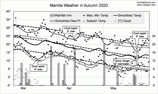
Instead of warm spells as in autumn 2019, this season had several cool spells. Three or four had cool days, but one in mid-march had cooler nights. Cool days in late May came with a very narrow daily temperature range, high humidity and cloud.
There were 18 rain days (normally 14) spread through the season, with the highest reading (20.0 mm) on the 1st of May.

Weather log autumn 2020

Comparing autumn seasons

In contrast to the previous two autumn seasons, autumn 2020 was cool and moist. Days (24.4 deg) were 2nd coolest for autumn in the new century (after 2003). Night temperatures were normal, and the mean one degree low.
The rainfall total, 124 mm, was at the 55th percentile, not far below the mean of 134 mm. Other moisture measures were higher: early morning dew point was 9.0 deg, cloudiness 41%, and daily temperature range 13.8 deg.

Climate for autumn 2020


Data. The Bureau of Meteorology automatic rain gauge, Manilla Museum, Station 55312, recorded no readings from 24th February 2020 until 11th March 2020. I used my own readings for that period. Readings later in autumn are from the Manilla (Museum) gauge.

My estimates of early morning dew point have become anomalously low. From 1 August 2019, I use values taken from Tamworth Airport graphs at the time of minimum temperature.
All other data, including subsoil at 750 mm, are from 3 Monash Street, Manilla.

Cool spring 2016

Photo of a wildflower

Nodding Chocolate Lilies

Through September, days were very cool, making for a narrow daily temperature range. Then, through October, both days and nights were very cool. In November, days and nights were nearer to normal but, in contrast to September, the daily temperature range was wide. The dew point failed to rise during the season, making the air very dry in November.
Rain fell frequently up to the middle of November, then ceased. There were 24 rain days, when there are normally 19 in spring. The highest reading was 28.8 mm on the 14th of September. The season total of 216.4 mm was rather high, in the 77th percentile.

Graphical log for spring 2016
All temperature measures were below normal by 1.5° to 2.0°. Only spring of 2001 had low values like that but in 2010 the mean daily maximum (only) was 2.5° below normal.
Measures of moisture were near normal, with cloud, rainfall, and daily temperature range on the moist side, and dew point on the dry side.

Climate for spring 2016


Data. Rainfall figures for this season began from the automatic rain gauge at Manilla, published on the internet by the Bureau of Meteorology as Station 55031. That gauge ceased reporting on the 8th of October, and later readings are from my non-standard gauge. All other data, including subsoil at 750 mm, are from 3 Monash Street, Manilla.

Extremely wet winter 2016

Water flowing over a weir

Manilla Weir Fish Ladder

This winter, with 227.4 mm of rain, was the fifth wettest in the record from 1883. In order of rainfall, wetter winters were: 1920 (318 mm), 1998 (304 mm), 1950 (261 mm) and 1952 (233 mm). This winter’s total was more than 100 mm over the average (125 mm). The heaviest daily fall, 37 mm, was on 5 June, and there were four other falls of more than 15 mm; two in June and two in August.
There were big week-long swings in temperature through June and July. On four occasions nights were more than four degrees warmer than normal and on one occasion days were four degrees cooler than normal. No such swings occurred from late July to mid-August, then days became five degrees cooler than normal. In this winter, there were few spells of either hot days or cold nights. The number of frosts (42) was near the usual number (44).

Graphical log for winter 2016
While the mean temperature of the season was normal, most other measures of climate were not.
The winter seasons of 2016 and 2010 were both extremely moist. Winter 2016 had more rain (227 mm versus 160 mm) and more cloudy days (53% versus 49%). In other respects 2010 was more moist: the dew point was higher (3.7° versus 2.5°), and the days had a narrower temperature range (12.5° versus 12.8°). The daily temperature range for winter is usually much wider: 15.3°. It was 17.5° in winter 2002!

Climate for winter 2016


Rainfall figures for this month are from the automatic rain gauge at Manilla, published on the internet by the Bureau of Meteorology as Station 55031. All other data, including subsoil at 750 mm, are from 3 Monash Street, Manilla.

Autumn 2016 had many warm spells

Photo of a garden in Manilla NSW

Autumn Garden

The season was marked by a series of warm spells. The three warmest, coming early in each month, reached 3° to 4° above normal. In the first two, days and nights were equally warm; in the third, nights were much higher above normal than days, making the daily temperature range narrower than normal by 4°. The only cool spells having temperatures below normal were in the third week of March and the last week of May. All three frosts of this season came in the final week .
Rain came in five episodes, spaced a week or two apart. There were 12 rain days, which is the usual number, but the highest reading was only 20.8 mm.

Weather log for autumn 2016
This was the warmest autumn in this short record. Daily maximum, mean, and minimum temperatures were all more than 1.5° above the average for the decade beginning March 1999. The subsoil temperature at 750 mm was also rather high.
The composite Moisture Index was normal, rainfall being a little low and cloudiness rather high (36%, when the autumn “normal” is 25%).
The total rainfall of 88.3 mm was below the autumn average of 134 mm, and in the 35th percentile.

Climate for autumn 2016.


All data, including subsoil at 750 mm, are from 3 Monash Street, Manilla. Rainfall data up to 26/3/15 is from Manilla Post Office, Station 055031.

Summer 2015-16 cool then warm

Photo of San Pedro cactus blooming

San Pedro cactus blooms

Taken as a whole, this summer was nearer to normal than last summer. Several numbers were close to average: daily maximum temperature, daily mean temperature, daily minimum temperature, and daily temperature range. The mean early morning dew point was rather low, while the cloudiness and total rainfall were a little high.
There were two very hot days over 40° (the usual number) and 29 hot days over 35° (just 6 more than usual).

Weather log for summer 2015-16A very cool spell came in early December, between other cool spells in late November and late December. Then, from mid-February through to early autumn, the weather was very warm. With this warmth came dry air, a wide daily temperature range, and sunny skies.
The total rainfall of 253.6 mm was above the summer average of 227 mm. After 20 rain days (the usual number), rainfall ceased on the 4th of February. Had it continued, the total might have reached a very wet 350 mm.

Climate log for summer 2015-16.


All data, including subsoil at 750 mm, are from 3 Monash Street, Manilla. Rainfall data up to 26/3/15 is from Manilla Post Office, Station 055031.