June 2020: warm and dry again

Weather log for June 2020

[Note.
Due to illness, the first seven days of this month were missed for some Manilla values. No actual values were noted for cloud or soil temperature. Daily maximum and minimum air temperatures were estimated by regression on values from Tamworth Airport Automatic Weather Service. Further illness has delayed publication.]

The second week was nearly 3° above normal. One day (13th) was 5.9° above normal. and one night (14th) a remarkable 9.6° above normal. That night also recorded the highest rainfall: 15.2 mm). Later, a cold day, 5.5° below normal, occurred on the 23rd.

Weather log June 2020 Manilla

Comparing June months

All three mean monthly temperatures were one degree above normal, a little warmer than in June last year. The Subsoil temperature was 2 deg above normal.
Moisture indicators were near normal, except for rainfall.
The rainfall total of 20.8 mm was at the 28th percentile for June, which was less than half the long-term average.

Climate Manilla June 2020

Drought

I will report separately on the on-going drought.


Data. A Bureau of Meteorology automatic rain gauge operates in the museum yard. From 17 March 2017, 9 am daily readings are published as Manilla Museum, Station 55312.  These reports use that rainfall data when it is available. Recording resumed on 20 July 2019. The gauge failed again during February (25/02/2020 ), but was repaired on 11/3/20.
My estimates of early morning dew point have drifted anomalously low. From August 2019, I use data from the Tamworth Airport published graphs.
All other data, including subsoil at 750 mm, are from 3 Monash Street, Manilla.

A cool moist autumn in 2020

The daily weather log

[Note.
Due to illness, 45 days of this season, from 23rd March to 7th May, were missed for some Manilla values. No values were noted for cloud or soil temperature; mean values shown for the season are estimates only. Missed values of daily maximum and minimum air temperatures were estimated by regression on values from Tamworth Airport Automatic Weather Service.]

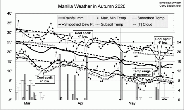
Instead of warm spells as in autumn 2019, this season had several cool spells. Three or four had cool days, but one in mid-march had cooler nights. Cool days in late May came with a very narrow daily temperature range, high humidity and cloud.
There were 18 rain days (normally 14) spread through the season, with the highest reading (20.0 mm) on the 1st of May.

Weather log autumn 2020

Comparing autumn seasons

In contrast to the previous two autumn seasons, autumn 2020 was cool and moist. Days (24.4 deg) were 2nd coolest for autumn in the new century (after 2003). Night temperatures were normal, and the mean one degree low.
The rainfall total, 124 mm, was at the 55th percentile, not far below the mean of 134 mm. Other moisture measures were higher: early morning dew point was 9.0 deg, cloudiness 41%, and daily temperature range 13.8 deg.

Climate for autumn 2020


Data. The Bureau of Meteorology automatic rain gauge, Manilla Museum, Station 55312, recorded no readings from 24th February 2020 until 11th March 2020. I used my own readings for that period. Readings later in autumn are from the Manilla (Museum) gauge.

My estimates of early morning dew point have become anomalously low. From 1 August 2019, I use values taken from Tamworth Airport graphs at the time of minimum temperature.
All other data, including subsoil at 750 mm, are from 3 Monash Street, Manilla.

May 2020: still cool and moist

Weather log for May 2020

[Note.
Due to illness, the first seven days of this month were missed for some Manilla values. No actual values were noted for cloud or soil temperature. Daily maximum and minimum air temperatures were estimated by regression on values from Tamworth Airport Automatic Weather Service.]

May weekly mean temperatures were slightly below normal, except in the final days.
The weather varied with three rainy periods about the 1st (20.0 mm), 10th, and 21st. At these times, skies were cloudy, dew points were high, nights were warm and days cold. The daily maximum temperature on the 23rd (10.7°) was the lowest for May in the new century. The first frost came on the 11th May, near the median date for it.

Comparing May months

The climate this May marked a return to the cool and moist conditions of May 2015. It was quite different from May 2018, which was warm and dry, and from May 2019, which was warm and wet.

While the mean monthly temperature (13.0°) was rather low, the mean daily maximum (19.9°) was the lowest on record for May. The mean daily minimum (6.0°) was normal.
The rainfall total of 38.4 mm was at the 59th percentile for May, which was near the average (41 mm). Early morning dew point (4.8°) was also near normal, while moister climate was shown by high cloudiness (42%) and narrow daily temperature range (13.9°).

Drought

I will report separately on the on-going drought.


Data. A Bureau of Meteorology automatic rain gauge operates in the museum yard. From 17 March 2017, 9 am daily readings are published as Manilla Museum, Station 55312.  These reports use that rainfall data when it is available. Recording resumed on 20 July 2019. The gauge failed again during February (25/02/2020 ), but was repaired on 11/3/20.
My estimates of early morning dew point have drifted anomalously low. From August 2019, I use data from the Tamworth Airport published graphs.
All other data, including subsoil at 750 mm, are from 3 Monash Street, Manilla.

3-year trends to May 2020

May, like March and April, continued cool

May raw anomaly data (orange)

Current raw anomaly values for May appeared very little changed from those of March and April. However, as noted below, many values are estimates only.

Temperatures

Daily maximum temperature anomaly (all x-axes), which had been very high until January, remained near -1.5°.
Daily minimum temperature anomaly (lower left): stayed at normal.
Subsoil temperature anomaly (lower right): stayed at normal.

Moistures (moist is at the bottom)

Rainfall anomaly (upper left) stayed near normal.
Cloudiness anomaly (upper right): remained high.
Dew point anomaly (middle left): remained normal.
Daily temperature range anomaly (middle right) stayed low, near -1.5°.

 Fully smoothed data values (red) 

Fully-smoothed data is now available for the spring season (SON) of 2019. Taking the season as a whole, smoothed daily maximum temperature anomaly peaked (at the 21st-century record value of +2.21°) in October, while daily minimum temperature rose, and subsoil temperature fell. A steady movement away from extreme drought affected rainfall, cloudiness, dew point, and daily temperature range (lower).

[Note.
Due to illness, 45 days were missed for some Manilla values, from 23/3/20 to 8/5/20. No values were noted for cloud or soil temperature; daily maximum and minimum air temperatures were estimated by regression on values from Tamworth Airport Automatic Weather Service.]


Notes:

January data points are marked by squares.

Smoothing Continue reading

April 2020: cool, moist

Weather log for April 2020

[Note.
Due to illness, all days of this month were missed for some Manilla values. No values were noted for cloud or soil temperature; mean values shown for the month are estimates only. Daily maximum and minimum air temperatures were estimated by regression on values from Tamworth Airport Automatic Weather Service.]

April weekly mean temperatures were one or two degrees below normal, except in the final week.
There were five rain days, with the highest reading of 18.4 mm on the 11th.

Comparing April months

The mean monthly temperature, at 17.7°, was rather low, half a degree below normal. The mean daily maximum, at 24.7°, was one-and-a-half below normal, while the mean daily minimum, at 10.7°, was normal.
Apart from rainfall, the only moisture indicator available this month is daily temperature range. At nearly 2° narrower than normal, it implies more moist conditions than the rainfall. The rainfall total of 32.8 mm was at the 50th percentile for April, which is rather below the average (44 mm).

Drought

I will report separately on the on-going drought.


Data. A Bureau of Meteorology automatic rain gauge operates in the museum yard. From 17 March 2017, 9 am daily readings are published as Manilla Museum, Station 55312.  These reports use that rainfall data when it is available. Recording resumed on 20 July 2019. The gauge failed again during February (25/02/2020 ), but was repaired on 11/3/20.
My estimates of early morning dew point have drifted anomalously low. From August 2019, I use data from the Tamworth Airport published graphs.
All other data, including subsoil at 750 mm, are from 3 Monash Street, Manilla.