
The daily weather log
[Note.
Due to illness, 45 days of this season, from 23rd March to 7th May, were missed for some Manilla values. No values were noted for cloud or soil temperature; mean values shown for the season are estimates only. Missed values of daily maximum and minimum air temperatures were estimated by regression on values from Tamworth Airport Automatic Weather Service.]
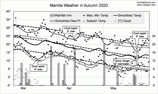
Instead of warm spells as in autumn 2019, this season had several cool spells. Three or four had cool days, but one in mid-march had cooler nights. Cool days in late May came with a very narrow daily temperature range, high humidity and cloud.
There were 18 rain days (normally 14) spread through the season, with the highest reading (20.0 mm) on the 1st of May.
Comparing autumn seasons
In contrast to the previous two autumn seasons, autumn 2020 was cool and moist. Days (24.4 deg) were 2nd coolest for autumn in the new century (after 2003). Night temperatures were normal, and the mean one degree low.
The rainfall total, 124 mm, was at the 55th percentile, not far below the mean of 134 mm. Other moisture measures were higher: early morning dew point was 9.0 deg, cloudiness 41%, and daily temperature range 13.8 deg.

Data. The Bureau of Meteorology automatic rain gauge, Manilla Museum, Station 55312, recorded no readings from 24th February 2020 until 11th March 2020. I used my own readings for that period. Readings later in autumn are from the Manilla (Museum) gauge.
My estimates of early morning dew point have become anomalously low. From 1 August 2019, I use values taken from Tamworth Airport graphs at the time of minimum temperature.
All other data, including subsoil at 750 mm, are from 3 Monash Street, Manilla.

Surly, it’s good to see you back online! Can you clarify the rainfall percentile? You state that 124mm was the 55th percentile but was below the mean of 134mm. I would have thought the 55th percentile would have to be above the mean? Or am I confusing this with the median?
Hi, Allan.
Yes, indeed you are confusing mean (or average) with median. You are not alone in this. Mean and median are related by skewness. The subject of skewness, as described in Wikipedia, is full of paradox.
Mean and median
The mean is the sum of all observations divided by the number of observations. The median is the 50th percentile: half of all observations are higher than the median, and half are lower.
The main thing that can cause the mean of a distribution to be higher than the median is right skewness. Right skewness is when the graph (histogram) of the distribution has a tail extending the the right (to the large numbers).
My Manilla rainfall data
I have plotted the histograms of all the following distributions for Manilla rainfall:
* annual rainfall totals;
* seasonal rainfall totals for spring, summer, autumn, and winter;
* monthly rainfall totals for January, February, March, April, May, June, July, August, September, October, November, and December.
In every one of those histograms, a tail extends to the right, and the value of the mean is higher than the value of the median. The smallest difference (in mm) is in August, when the mean (40 mm) is only 4 mm above the median (36 mm). The largest difference is in February, when the mean (67 mm) is 21 mm above the median (46 mm).
Median, mean and skewness
I assumed that the shape of these histograms, and the fact that the mean was above the median in each case meant that all the distributions were right-skewed. Wikipedia assures me that I may be wrong.
I was using the “older notion” of nonparametric skew. In the “modern definition” of skewness, right-skewness may occur with the mean either on the left or the right of the median. My father would have said that is “as clear as mud”.