3-year trends to March 2020

March continued cool

March raw anomaly data (orange)

Temperatures

Daily maximum temperature anomaly (all x-axes), which had been very high until January, remained below -1.5°.
Daily minimum temperature anomaly (lower left): fell to just below normal.
Subsoil temperature anomaly (lower right): was still near normal.

Moistures (moist is at the bottom)

Rainfall anomaly (upper left) fell from plus 100 mm/month to normal.
Cloudiness anomaly (upper right): remained high.
Dew point anomaly (middle left): returned to normal.
Daily temperature range anomaly (middle right) returned from -3.0° to -1.5°.

 Fully smoothed data values (red) 

Most smoothed anomaly values for September 2019 moved a little further towards drought. Smoothed daily maximum temperature anomaly reached a new 21st century record of +2.07° above normal in September, with a higher record to be expected in October or later.

[Note.
Due to illness, 45 days were missed for some Manilla values, beginning from 23/3/20. No values were noted for cloud or soil temperature; daily maximum and minimum air temperatures were estimated by regression on values from Tamworth Airport Automatic Weather Service.]


Notes:

January data points are marked by squares.

Smoothing Continue reading

No Rain Days in April 2019

Split Rock Reservoir 4-5-19

A warm spell in the third week was 4.2° above normal. There were 29 days over 25°, many more than usual. Anzac Day (25th) was sunny, calm and warm. It reached 28.2°, which was four degrees above average for that day, but not up to the 28.7° of Anzac Day 2002.
There were no rain days (usually four) and the dew point on the 28th reached a record low April value of minus 3.2°. There were no frosts.

Weather log for April 2019

Comparing April months

This month was warm (average 19.8°), but not as warm as April 2018, 2016 or 2005. The mean daily maximum of 27.8° was well below that of April 2005 (29.5°).
There was no rain, as in April 1912, 1925, 1942 and 1971. Dry air was shown by early morning readings of low dew point (5.8°) and very low relative humidity (67%). However, normal moisture was shown by 30% cloudy days and a daily temperature range of 15.9°.

The last seven April months

Drought

The on-going unprecedented drought is reported in another post.


Data. A Bureau of Meteorology automatic rain gauge operates in the museum yard. From 17 March 2017, 9 am daily readings are published as Manilla Museum, Station 55312.  These reports use that rainfall data when it is available.  Since no 9 am readings have been recorded since August, I have substituted my non-standard gauge readings for all days.
All other data, including subsoil at 750 mm, are from 3 Monash Street, Manilla.

Very warm nights in March 2019

Photo of dead public lawn

Our Nature Strip

While there were no very high or low temperatures, weekly mean temperatures were high. Warm spells through the second and fourth week-ends were about four degrees high.
There were nine rain days (twice the usual number for March), but none had more than 5 mm until the 30th. A rain front early that morning brought 39 mm.

Weather log for March 2019

Comparing March months

This month was very warm. It was like March in 2018 and 2016, but the nights were warmer. Both the mean minimum temperature (17.9°) and the monthly mean temperature (24.9°) were record high values for March in the 21st century.
It was not a dry month: values of all the moisture indicators were near normal. The (estimated) rainfall of 54.9 mm is very close to the long-term average of 53.4 mm. However, March rainfall at Manilla is strongly skewed, having many values just below the average and just a few values up to 240 mm above it. The median March rainfall is much lower: only 39 mm. This month’s total of 54.9 mm is at the 60th percentile: it is higher than 60% of all historic March rainfall values.

The last 7 March months

Drought

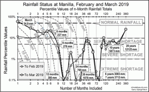
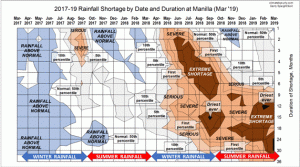
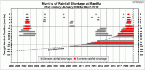
The on-going drought is reported in three posts, with three different kinds of graph:

  • a line graph shows rainfall status in the last two months, with duration on the x-axis and severity on the y-axis;
  • a contour graph shows 25 months sequentially on the x-axis, duration on the y-axis and severity by tints;
  • a duration graph shows how shortages began and ended in the last 20 years, with time on the x-axis and duration on the y-axis.


Data. A Bureau of Meteorology automatic rain gauge operates in the museum yard. From 17 March 2017, 9 am daily readings are published as Manilla Museum, Station 55312.  These reports use that rainfall data when it is available.  Since no 9 am readings have been recorded since August, I have substituted my non-standard gauge readings for all days.
All other data, including subsoil at 750 mm, are from 3 Monash Street, Manilla.

3-year trends to March 2019

March warm

3-year trends to March 2019

March raw anomaly data (orange)

In March 2019, the raw anomaly for daily maximum temperature was near the upper limit for normal. Daily minimum and subsoil temperatures were high. Rainfall and other moisture measures were near normal.

 Fully smoothed data (red)

Fully smoothed data to September 2018 (except daily minimum temperature anomaly) showed a movement away from drought. More recent data, only partially smoothed, suggest that temperatures and rainfall later returned towards drought.


Notes:

January data points are marked by squares.

Smoothing

Smoothing uses Gaussian functions.
For fully smoothed data the function has a Standard Deviation of 2.5 months, it spans 13 monthly data points, and has a half-width of 6 months, which suppresses cycles shorter than 12 months. For partly smoothed data, the span of the function is reduced to 11 months, 9 months and so on.
Continue reading

March 2018 very warm indeed

Acacia salicina

Young Cooba

Eight days went over 35° this March, beaten only by nine days in March 2016. The 19th (38.6°) was the fifth hottest March day of the new century. Weekly mean temperatures rose to 4.6° above normal by the 18th, and remained almost as high beyond the end of the month.
There were seven rain days, with the highest reading of 16.5 mm (est.) coming early in the month.

Weather log for March 2018

Comparing March months

Average temperatures this month very nearly match those of the record-breaking March 2016. They are only 0.1° lower! Moisture variables are also similar: rather dry, in stark contrast to the sogginess of March 2017.

The rainfall total of 25.6 mm (est.) was at the 40th percentile, well below the average (53 mm). Serious rainfall shortages are seen only in the medium term: the 60-month total of 2770 mm (8th percentile) and the 72-month total of 3410 mm (9th percentile).

Climate in March months


Data. A Bureau of Meteorology automatic rain gauge operates in the museum yard. From 17 March 2017, 9 am daily readings are published as Manilla Museum, Station 55312.  These reports use that rainfall data when it is available.  The gauge, which had last reported on 24 September 2017, came on line again on the 16th of March. However, not all later days have readings reported.

All data, including subsoil at 750 mm, are from 3 Monash Street, Manilla.