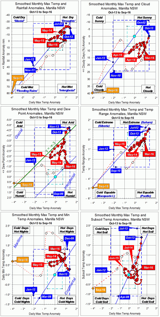
Parametric plots of smoothed climate variables at Manilla
“October 2016 still cold”

October raw anomaly data (orange)
In October 2016 daily maximum air temperature continued extremely low. Now daily minimum air temperature and subsoil temperature (bottom graphs) also became extremely low. Most other variables returned to near normal.
Fully smoothed data (red)
The latest fully-smoothed data point is April 2016.
By then, most anomalies were moving definitely towards cool and moist. However, daily minimum temperature and subsoil temperature were rising.
In April 2016, the smoothed anomaly of daily minimum temperature was extremely high. It was approaching the 18-year record value of +1.32°, set in December 2009.
Note:
Fully smoothed data – Gaussian smoothing with half-width 6 months – are plotted in red, partly smoothed data uncoloured, and raw data for the last data point in orange. January data points are marked by squares.
Blue diamonds and the dashed blue rectangle show the extreme values in the fully smoothed data record since September 1999.
Normal values are based on averages for the decade from March 1999.* They appear on these graphs as a turquoise (turquoise) circle at the origin (0,0). A range of anomalies called “normal” is shown by a dashed rectangle in aqua (aqua). For values in degrees, the assigned normal range is +/-0.7°; for cloudiness, +/-7%; for monthly rainfall, +/-14 mm.
* Normal values for rainfall are based on averages for the 125 years beginning 1883.