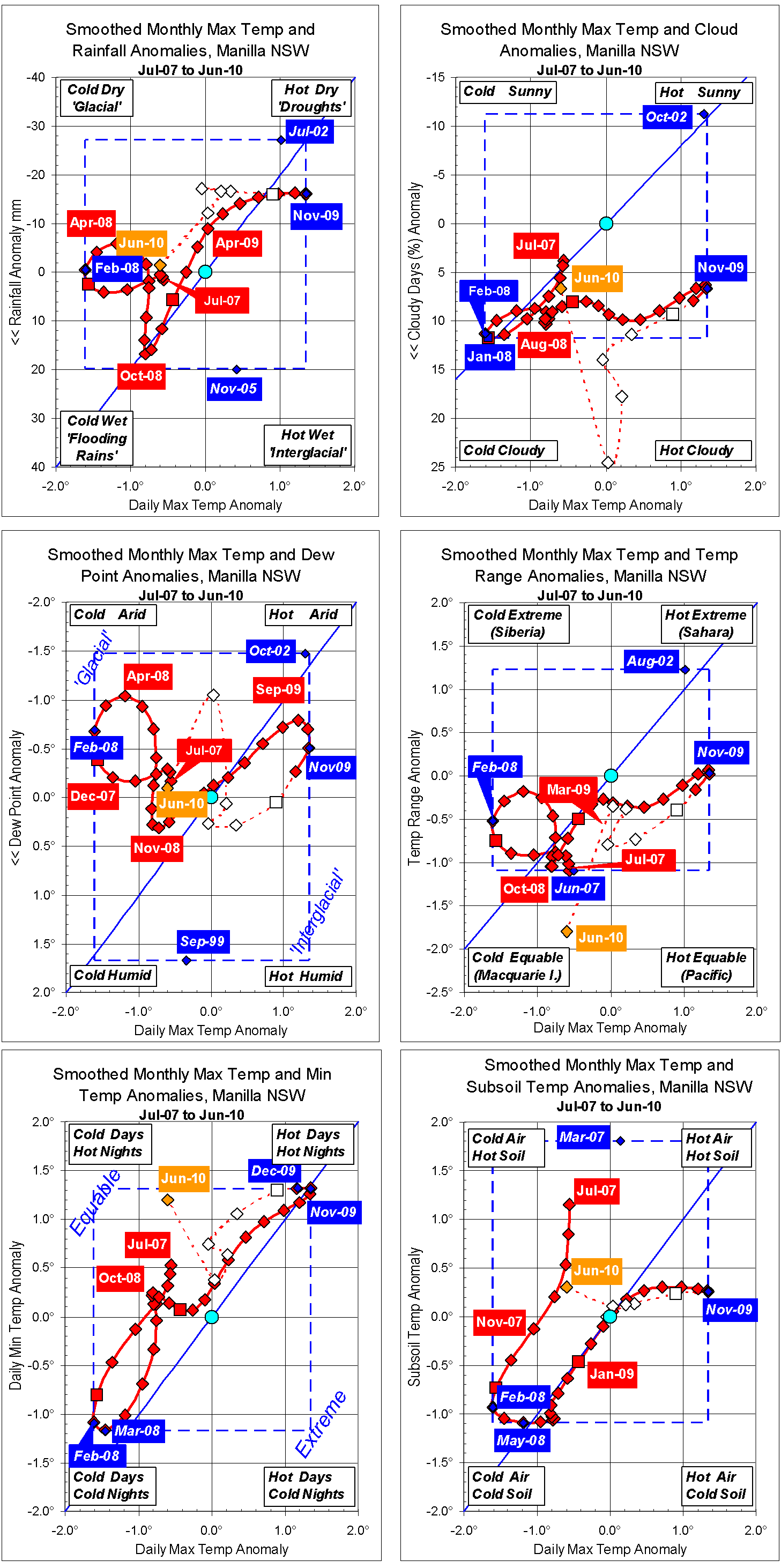
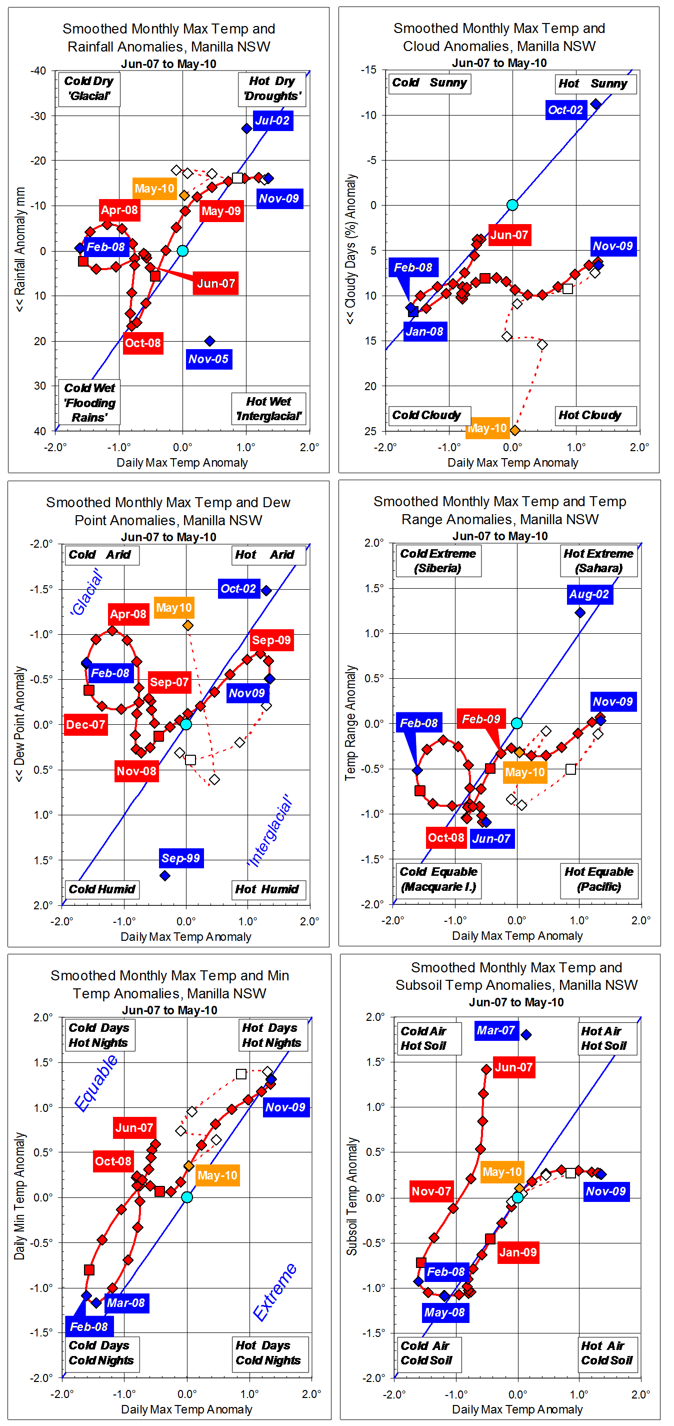
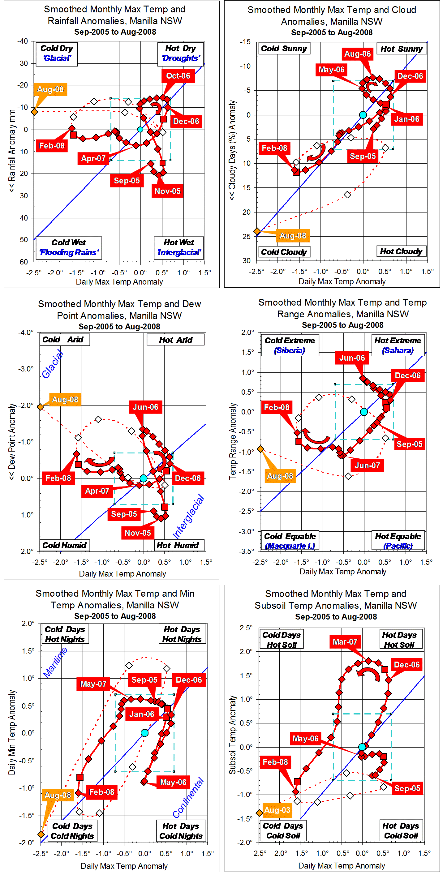
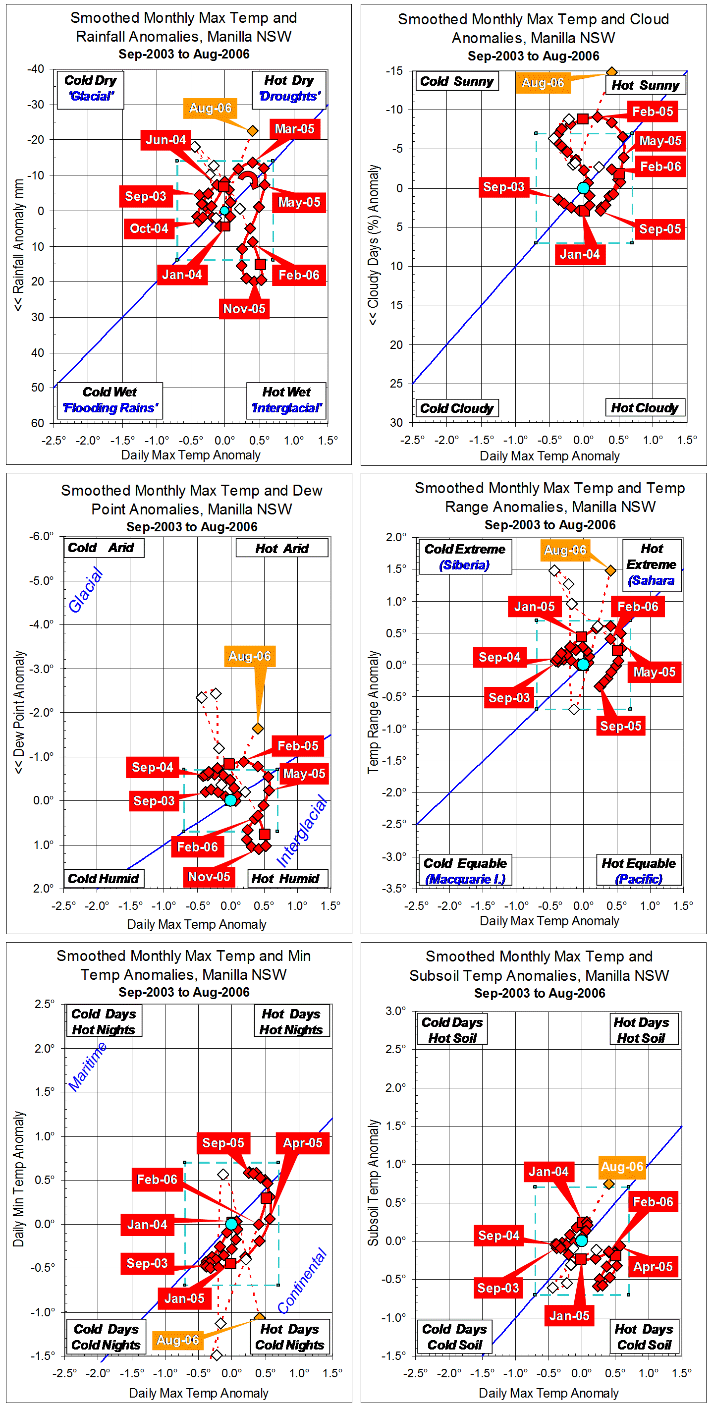
Parametric plots of smoothed climate variables at Manilla
“An extreme 1-year drought”

At Manilla a sudden extreme drought peaked in winter and spring of 2002. Each of seven climate variables went through a large cycle, with a peak at the top right-hand corner of its graph.
(Note added in May 2014: This 2002 event is the most extreme rainfall drought at Manilla so far in the 21st century. Current conditions may perhaps be similar.)
Extreme values of anomalies.
The smoothed anomaly of daily maximum temperature (X-axis on all graphs) exceeded +0.7° in June 2002, and remained above that value until December. It peaked at +1.30° in September-October 2002. (Note added: This stood as a record high value for seven years until October 2009.)
Smoothed monthly rainfall anomaly fell below -14 mm in February 2002, and remained below that value until November. It peaked (negative) at -27.1 mm in July 2002. (Note added: In May 2014 this still stands as a record low value.)
The smoothed anomaly of percent cloudy mornings (more than 4 octas) fell below -7% in July 2002, and remained below that value until December 2002. It peaked (negative) at -11.3% in October 2002. (Note added: In May 2014 this still stands as a record low value. More cloud in recent years has made negative anomalies rare.)
The smoothed anomaly of early morning dew point fell below -0.7° in May 2002, and remained below that value until January 2003. It peaked (negative) at -1.48° in September-October 2002. (Note added: This stood as a record low value until June 2011. Since then, the air has become much drier, taking anomaly values three times as low.)
The smoothed anomaly of daily temperature range, like that of daily maximum temperature, was positive during the drought. It exceeded +0.7° in April 2002, and remained above that value until November. It peaked at +1.23° in July-August 2002. (Note added: In May 2014 this still stands as a record high value.)
Smoothed daily minimum temperature anomaly reached a maximum of only +0.38° at the peak of the drought in November 2002. It had risen smoothly from the strongly negative value of -0.91° in November 2001. Through 2002, the rise in daily minimum temperature lagged behind that of daily maximum temperature, resulting in a “continental” type of climate with wide daily temperature range. (Note added: Higher daily minimum temperature anomalies occurred in winter 2007, and much higher ones in spring 2009.)
The smoothed anomaly of subsoil temperature, like that of daily maximum temperature, was positive during the drought. It exceeded +0.7° in August 2002, and remained above that value until February 2003. It peaked at +1.48° in November 2002. (Note added: This value was exceeded from January to May 2007, and further exceeded in winter 2013.)
Leads and lags.
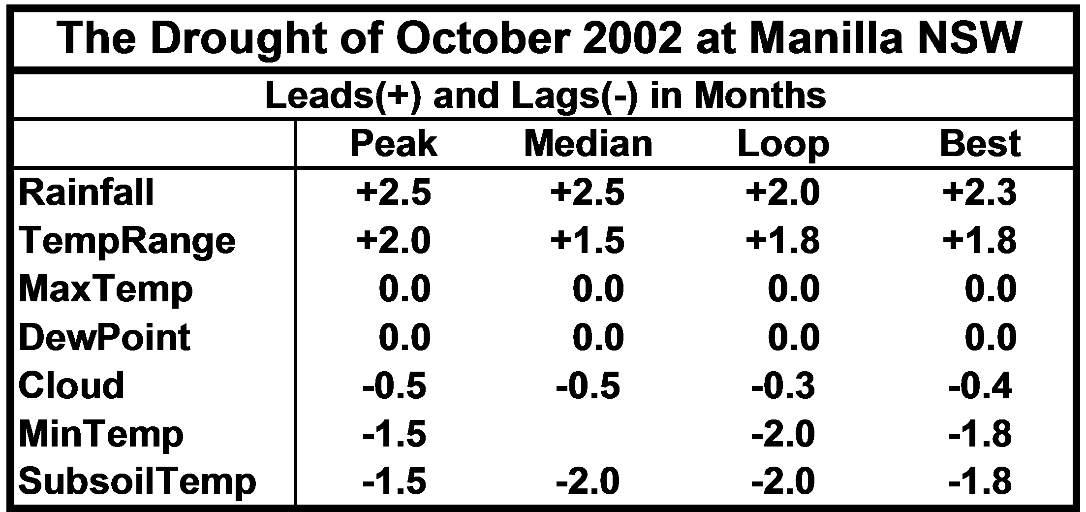
The climate variables did not all peak at once: some led, and some lagged. In the table below I show three estimates of lead or lag (in months):
- I identified dates of peak value on the graphs;
- I noted a point mid-way between the date of departure from normal and that of return to normal as the median date;
- Where the line on the graph formed a hysteresis loop (shown by a curved arrow), I drew other graphs with a lead or lag imposed to compensate for the actual lead or lag. I estimated the amount of lead or lag that would make the loop into a straight line.

In the table, I take the dates for highest excess of daily maximum temperature as the standard, to show the pattern of leads and lags of the other variables. Rainfall deficit led by 2.3 months and daily temperature range excess led by 1.8 months. Early morning dew point deficit (dry air) did not lead or lag. The deficit in cloud amount lagged by 0.4 months, and the excess of both daily minimum temperature and subsoil temperature lagged by 1.8 months.
(Note added: Leads and lags in more recent climate events at Manilla have a pattern that is similar, but not the same.)
Note:
Fully smoothed data – Gaussian smoothing with half-width 6 months – are plotted in red, partly smoothed data uncoloured, and raw data for the last data point in orange. January data points are marked by squares.
Normal values are based on averages for the decade from March 1999. They appear on these graphs as a turquoise (turquoise) circle at the origin (0,0). A range of anomalies called “normal” is shown by a dashed rectangle in aqua (aqua). For values in degrees, the assigned normal range is +/-0.7°; for cloudiness, +/-7%; for monthly rainfall, +/-14 mm.
(Note added in May 2014: A much later post titled “3-year trends to May 2010” is the first of a consecutive series of parametric plots, updated monthly at the time of observation and originally posted elsewhere.
This earlier data was not edited in this form at the time.
To display all existing fully-smoothed data points at least once, I have prepared these back-dated posts in the same format for:
“3-year trends to August 2002” which includes smoothed data September 1999 to February 2002, covering the calendar years 2000 and 2001.
“3-year trends to August 2004” (this post) which includes smoothed data September 2001 to February 2004, covering the calendar years 2002 and 2003.
“3-year trends to August 2006” which includes smoothed data September 2003 to February 2006, covering the calendar years 2004 and 2005.
“3-year trends to August 2008” which includes smoothed data September 2005 to February 2008, covering the calendar years 2006 and 2007.
In these back-dated posts the anomaly values depend on climate normals that are based on the decade ending February 2009, and were thus not available until after that date. I have written the posts as if they were available at the time.
In places I have written some “Notes added in May 2014” (like this) commenting on how values observed at that time relate to more recent events.)