The 2002 drought contour chart

Contour chart 2002 drought at Manilla NSW

The 2002 drought at Manilla was a failure of winter rainfall. [See Note below: “Manilla’s rainfall seasonality”.]

The top line of this contour chart shows that monthly rainfall shortages occurred in all the six months of winter rainfall dominance (April to September) of 2002. Shortages in May and July were severe, below the 5th percentile. In the summer rainfall months (October to March) that preceded and followed, rainfall was near or above normal. [See Note below: “Classes of rainfall shortage”.]

Lower down the contour chart, rainfall shortages of longer duration are shown. For droughts of 3 months duration, the rainfall shortage was extreme (1st percentile) by July 2002, as it included the serious shortage of May as well as that of July. In the same way, one sees extreme 6-month shortages in September and October, as all the monthly rainfall shortages since March added up.

By November 2002, one sees extreme droughts of 9 months and 12 months duration. The 9-month drought incorporated the consecutive months of below-normal rainfall from March to November. The extreme 12-month drought (307 mm) that was evident in November 2002 began earlier, with below-normal rainfalls in December 2001 and January 2002. That was the fourth driest 12-month period on record, after October 1965 (288 mm), August 1946 (302 mm) and November 1965 (304 mm).

The 2002 drought had no extreme rainfall shortages longer than 12 months. There were, however, some severe shortages of 18 months duration and some serious shortages of 24 months duration, due to some low rainfalls in the previous winter (2001).

By April 2003, hardly any serious rainfall shortages due to the 2002 drought remained. [See Note below: “Limitations of this analysis”]

More about the 2002 drought

Graph of monthly percentile rainfall in a drought
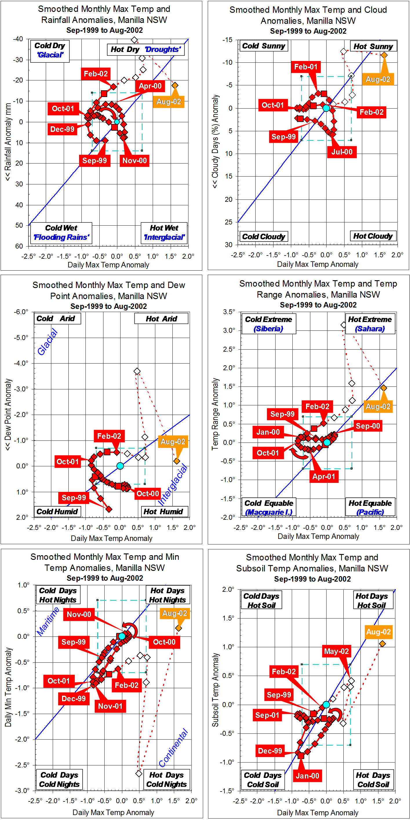
Another approach to describing this 2002 drought is in the post “The 2002 rainfall shortages at Manilla”. That post has a graph showing selected monthly profiles of percentile values. It also links to two earlier posts with graphs of smoothed values of climatic anomalies.

The 2018 Drought

Drought 2018 contour chartA similar contour plot for the drought of 2018 reveals similarities and differences.

The drought of 2018-19 developed to become the worst on record at Manilla. Contour graphs in this format, current to May 2019, are in “Rainfall shortage: series of contour plots”.


Note: Classes of rainfall shortage

Continue reading

The 2002 rainfall shortages at Manilla

Graph of monthly percentile rainfall in a drought

In 2002, Manilla had a 6-month drought with one of the most extreme rainfall shortages on record. In nearly fifty years since 1966 there have been no other shortages like it.

I have discussed this drought in two posts: “Profile of an Extreme Drought”, and 3-year trends to August 2004 (An extreme 1-year drought).

[For an update on the longer and more extreme drought of 2018-19, see the note below.]

This post is about the rainfall record only. It compares the percentile values of rainfall totals for groups of months: one month, two months, and so on. The graph shows how the drought began, developed and faded. Other droughts may go through similar stages. I have plotted the pattern of rainfall shortages month by month, showing only even-numbered months. I have plotted them in different colours, with matching “Call-out” labels.

April 2002 (Red): no drought yet.
In April, the monthly rainfall was slightly below average: in the 40th percentile. In this month, nearly all rainfall totals up to the 42-month total were also below average. Only the 6-month total was above average. This set up the conditions for a drought. Notice that rainfall totals for periods longer than 42 months were all well above average. This hardly changed at all in this year. There had been a lot of rain in previous decades.

June 2002 (Orange): 2, 3, and 4-month droughts.
When May rainfall was in the 1st percentile and June rainfall in the 25th percentile, the June 2, 3, and 4-month totals became serious or severe shortages (below the 10th percentile).

August 2002 (Green): 2, 3, 4, 5, 6, and 9-month droughts.
With July rainfall again in the 1st percentile, and August rainfall in the 26th, the drought became extreme. The 4, 5, and 6-month totals were in the 1st percentile: few months had ever had such low figures.

October 2002 (Blue): 3, 4, 5, 6, 9, 12, 15, and 18-month droughts.
September and October both had rainfall in the 18th percentile. That relieved the short-term shortages somewhat, but not those in the medium term. Shortages in the 4, 5, and 9-month totals were in the 1st percentile, but the 6-month total was very much worse. At 76 mm, this 6-month total was the third driest on record, beaten only by August 1888 (43 mm) and September 1888 (69 mm).

December 2002 (Purple): only 9- and 12-month droughts remain.
November rainfall that was near average (40th percentile) and high December rainfall (84th percentile) broke the drought. Only some longer-term effects persisted as severe rainfall shortages in 9- and 12-month totals.

Rainfall status Jan-Feb 2019


Note added 2019.
Later such graphs in this blog have a logarithmic scale to distinguish the extreme rainfall shortages. Here is the one for the even more extreme drought of February 2019.

Profile of an Extreme Drought

Rainfall vs Maximum temperature, 2002 droughtAt Manilla, NSW, there was a drought in 2002 that was extreme, but brief. There have been no other extreme droughts at Manilla in the 21st century. The current drought is not as bad (yet).
The first graph shows a profile of the 2002 drought. Low rainfall is at the top, and hot days are on the right. Droughts, with low rainfall and hot days, will be near the top right corner. Normal climate is marked by a rectangle (coloured aqua (aqua)) in the middle.
The climate in these months moved into drought and out of it. January 2001 (Start) had perfectly normal climate with no drought, and so did February 2003 (Finish). Rainfall first became lower than normal after January 2002, and reached a minimum 27 mm below normal in July 2002. Rainfall returned to the normal range by December 2002. Day-time temperature went above the normal range in May 2002, reached a peak 1.3 degrees above normal in September-October 2002, and fell back into the normal range in January 2003. For rainfall lower than normal, the drought lasted ten months: for days hotter than normal, it lasted eight months. In this drought, the time of lowest rainfall came two to three months earlier than the time of hottest days.

(There is more detailed analysis of  the 2002 drought in a post dated September 2004.)

Graphs showing the progress of the drought as rainfall shortages are in the post “The 2002 rainfall shortages at Manilla”.

The loop on the graph shows this drought as a simple event with a beginning, a middle, and an end. Droughts are not usually seen to be so simple. This graph is made using two “tricks”: anomalies and smoothing. You must judge whether you trust them to describe the drought as it happened.

Continue reading

3-year trends to August 2004

Parametric plots of smoothed climate variables at Manilla

“An extreme 1-year drought”

Trends to August 2004

At Manilla a sudden extreme drought peaked in winter and spring of 2002. Each of seven climate variables went through a large cycle, with a peak at the top right-hand corner of its graph.

(Note added in May 2014: This 2002 event is the most extreme rainfall drought at Manilla so far in the 21st century. Current conditions may perhaps be similar.)

Extreme values of anomalies.

The smoothed anomaly of daily maximum temperature (X-axis on all graphs) exceeded +0.7° in June 2002, and remained above that value until December. It peaked at +1.30° in September-October 2002. (Note added: This stood as a record high value for seven years until October 2009.)
Smoothed monthly rainfall anomaly fell below -14 mm in February 2002, and remained below that value until November. It peaked (negative) at -27.1 mm in July 2002. (Note added: In May 2014 this still stands as a record low value.)
The smoothed anomaly of percent cloudy mornings (more than 4 octas) fell below -7% in July 2002, and remained below that value until December 2002. It peaked (negative) at -11.3% in October 2002. (Note added: In May 2014 this still stands as a record low value. More cloud in recent years has made negative anomalies rare.)
The smoothed anomaly of early morning dew point fell below -0.7° in May 2002, and remained below that value until January 2003. It peaked (negative) at -1.48°  in September-October 2002. (Note added: This stood as a record low value until June 2011. Since then, the air has become much drier, taking anomaly values three times as low.)
The smoothed anomaly of daily temperature range, like that of daily maximum temperature, was positive during the drought. It exceeded +0.7° in April 2002, and remained above that value until November. It peaked at +1.23°  in July-August 2002. (Note added: In May 2014 this still stands as a record high value.)
Smoothed daily minimum temperature anomaly reached a maximum of only +0.38° at the peak of the drought in November 2002. It had risen smoothly from the strongly negative value of -0.91° in November 2001. Through 2002, the rise in daily minimum temperature lagged behind that of daily maximum temperature, resulting in a “continental” type of climate with wide daily temperature range. (Note added: Higher daily minimum temperature anomalies occurred in winter 2007, and much higher ones in spring 2009.)
The smoothed anomaly of subsoil temperature, like that of daily maximum temperature, was positive during the drought. It exceeded +0.7° in August 2002, and remained above that value until February 2003. It peaked at +1.48°  in November 2002. (Note added: This value was exceeded from January to May 2007, and further exceeded in winter 2013.)

Leads and lags.

The climate variables did not all peak at once: some led, and some lagged. In the table below I show three estimates of lead or lag (in months):

  1. I identified dates of peak value on the graphs;
  2. I noted a point mid-way between the date of departure from normal and that of return to normal as the median date;
  3. Where the line on the graph formed a hysteresis loop (shown by a curved arrow), I drew other graphs with a lead or lag imposed to compensate for the actual lead or lag. I estimated the amount of lead or lag that would make the loop into a straight line.

Table of leads and lags of climate anomaly variables

In the table, I take the dates for highest excess of daily maximum temperature as the standard, to show the pattern of leads and lags of the other variables. Rainfall deficit led by 2.3 months and daily temperature range excess led by 1.8 months. Early morning dew point deficit (dry air) did not lead or lag. The deficit in cloud amount lagged by 0.4 months, and the excess of both daily minimum temperature and subsoil temperature lagged by 1.8 months.
(Note added: Leads and lags in more recent climate events at Manilla have a pattern that is similar, but not the same.)

Note:
Fully smoothed data – Gaussian smoothing with half-width 6 months – are plotted in red, partly smoothed data uncoloured, and raw data for the last data point in orange. January data points are marked by squares.
Normal values are based on averages for the decade from March 1999. They appear on these graphs as a turquoise (turquoise) circle at the origin (0,0). A range of anomalies called “normal” is shown by a dashed rectangle in aqua (aqua). For values in degrees, the assigned normal range is +/-0.7°; for cloudiness, +/-7%; for monthly rainfall, +/-14 mm.

(Note added in May 2014: A much later post titled “3-year trends to May 2010” is the first of a consecutive series of parametric plots, updated monthly at the time of observation and originally posted elsewhere.
This earlier data was not edited in this form at the time.
To display all existing fully-smoothed data points at least once, I have prepared these back-dated posts in the same format for:
“3-year trends to August 2002” which includes smoothed data September 1999 to February 2002, covering the calendar years 2000 and 2001.
“3-year trends to August 2004” (this post) which includes smoothed data September 2001 to February 2004, covering the calendar years 2002 and 2003.
“3-year trends to August 2006” which includes smoothed data September 2003 to February 2006, covering the calendar years 2004 and 2005.
“3-year trends to August 2008” which includes smoothed data September 2005 to February 2008, covering the calendar years 2006 and 2007.
In these back-dated posts the anomaly values depend on climate normals that are based on the decade ending February 2009, and were thus not available until after that date. I have written the posts as if they were available at the time.
In places I have written some “Notes added in May 2014” (like this) commenting on how values observed at that time relate to more recent events.)

3-year trends to August 2002

Parametric plots of smoothed climate variables at Manilla
“Years of stable climate”

Trends to August 2002

Note. This first set of six graphs shows fully-smoothed climate anomaly values beginning in September 1999. Although my observations began in March 1999, the 13-point smoothing function uses six data points before the first point of fully-smoothed data (as well as six data points after it). Fully-smoothed data points (red) cover the two and a half years (30 months) to February 2002. Data points after that date could not be not fully smoothed at the time. The 2002 drought is discussed in a following post.

In the period from September 1999 to February 2002, the climate was rather stable. Most smoothed anomaly values remained close to the origin.
Daily maximum temperature anomaly was negative (-0.8°) in December 1999 and again in September-October 2001.
Rainfall anomaly was negative (-14 mm) only after January 2002 when it was also rapidly falling further. Cloudiness was normal throughout.
The smoothed anomaly of early morning dew point began very positive: +1.67° in September 1999. (Note added: Even in May 2014, this stands as the highest smoothed dew point value on record.) By December 1999 the anomaly had fallen below +0.7°, but it hovered just above +0.7° for 10 months from April 2000 to January 2001, before returning to normal.
Temperature range remained near normal, as daily minimum temperature moved with daily maximum temperature.
Subsoil temperature followed daily maximum air temperature down and up again. However, for 17 months from October 2000 until February 2002 subsoil temperature remained steady just below normal.
As shown by the curved arrows, during this period of little climate change, low rainfall tended to follow high daily maximum temperature, narrow temperature range preceded low daily maximum temperature, and extremes of daily minimum temperature and of subsoil temperature followed those of daily maximum temperature in the same sense.

Note:
Fully smoothed data – Gaussian smoothing with half-width 6 months – are plotted in red, partly smoothed data uncoloured, and raw data for the last data point in orange. January data points are marked by squares.
Normal values are based on averages for the decade from March 1999. They appear on these graphs as a turquoise (turquoise) circle at the origin (0,0). A range of anomalies called “normal” is shown by a dashed rectangle in aqua (aqua). For values in degrees, the assigned normal range is +/-0.7°; for cloudiness, +/-7%; for monthly rainfall, +/-14 mm.

(Note added in May 2014: A much later post titled “3-year trends to May 2010” is the first of a consecutive series of parametric plots, updated monthly at the time of observation and originally posted elsewhere.
This earlier data was not edited in this form at the time.
To display all existing fully-smoothed data points at least once, I have prepared these back-dated posts in the same format for:
“3-year trends to August 2002” (this post) which includes smoothed data September 1999 to February 2002, covering the calendar years 2000 and 2001.
“3-year trends to August 2004” which includes smoothed data September 2001 to February 2004, covering the calendar years 2002 and 2003.
“3-year trends to August 2006” which includes smoothed data September 2003 to February 2006, covering the calendar years 2004 and 2005.
“3-year trends to August 2008” which includes smoothed data September 2005 to February 2008, covering the calendar years 2006 and 2007.
In these back-dated posts the anomaly values depend on climate normals that are based on the decade ending February 2009, and were thus not available until after that date. I have written the posts as if they were available at the time.
In places I have written some “Notes added in May 2014” (like this) commenting on how values observed at that time relate to more recent events.)