
Parametric plots of smoothed climate variables at Manilla
“Years of stable climate”
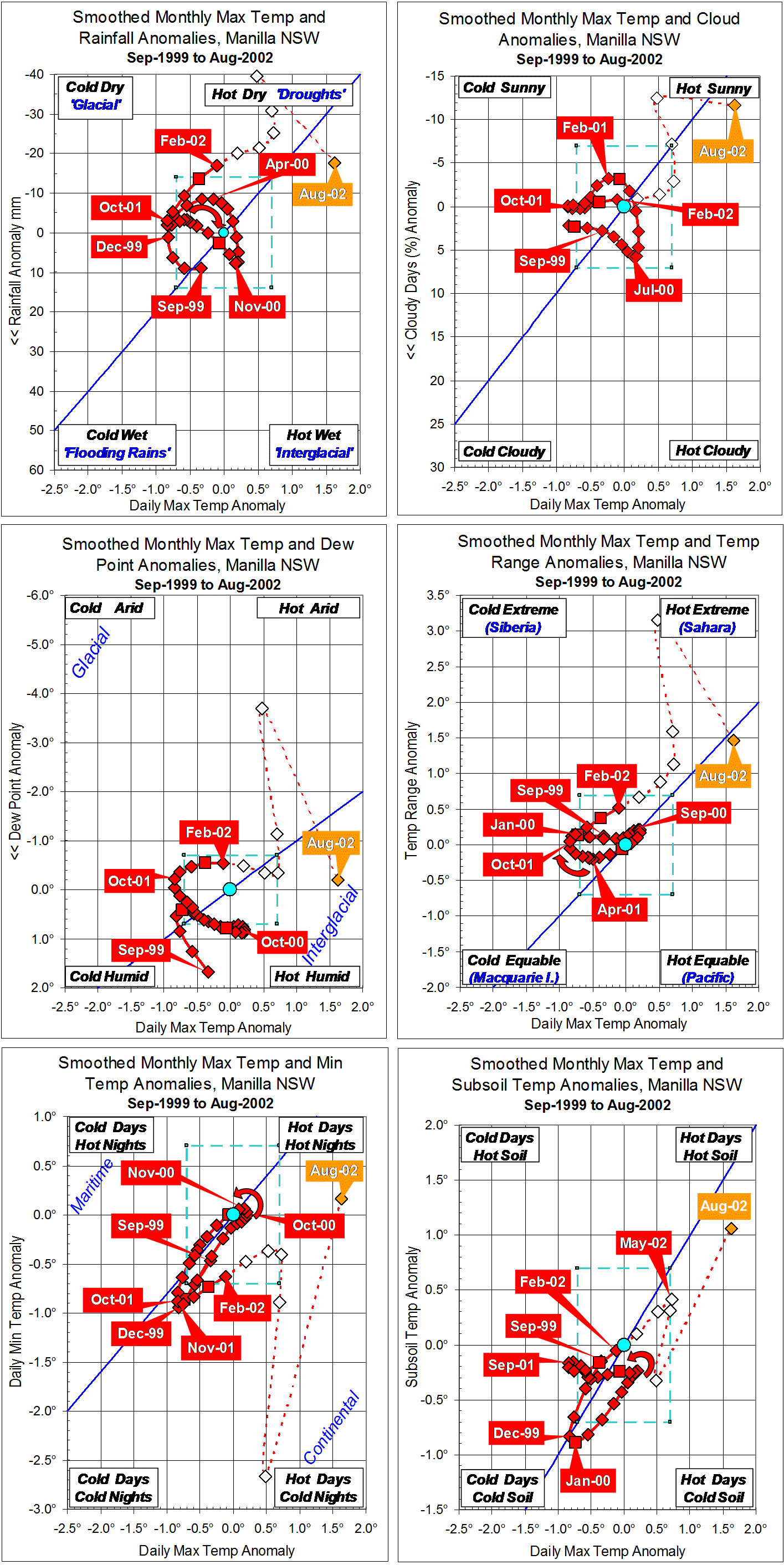
Note. This first set of six graphs shows fully-smoothed climate anomaly values beginning in September 1999. Although my observations began in March 1999, the 13-point smoothing function uses six data points before the first point of fully-smoothed data (as well as six data points after it). Fully-smoothed data points (red) cover the two and a half years (30 months) to February 2002. Data points after that date could not be not fully smoothed at the time. The 2002 drought is discussed in a following post.
In the period from September 1999 to February 2002, the climate was rather stable. Most smoothed anomaly values remained close to the origin.
Daily maximum temperature anomaly was negative (-0.8°) in December 1999 and again in September-October 2001.
Rainfall anomaly was negative (-14 mm) only after January 2002 when it was also rapidly falling further. Cloudiness was normal throughout.
The smoothed anomaly of early morning dew point began very positive: +1.67° in September 1999. (Note added: Even in May 2014, this stands as the highest smoothed dew point value on record.) By December 1999 the anomaly had fallen below +0.7°, but it hovered just above +0.7° for 10 months from April 2000 to January 2001, before returning to normal.
Temperature range remained near normal, as daily minimum temperature moved with daily maximum temperature.
Subsoil temperature followed daily maximum air temperature down and up again. However, for 17 months from October 2000 until February 2002 subsoil temperature remained steady just below normal.
As shown by the curved arrows, during this period of little climate change, low rainfall tended to follow high daily maximum temperature, narrow temperature range preceded low daily maximum temperature, and extremes of daily minimum temperature and of subsoil temperature followed those of daily maximum temperature in the same sense.
Note:
Fully smoothed data – Gaussian smoothing with half-width 6 months – are plotted in red, partly smoothed data uncoloured, and raw data for the last data point in orange. January data points are marked by squares.
Normal values are based on averages for the decade from March 1999. They appear on these graphs as a turquoise (turquoise) circle at the origin (0,0). A range of anomalies called “normal” is shown by a dashed rectangle in aqua (aqua). For values in degrees, the assigned normal range is +/-0.7°; for cloudiness, +/-7%; for monthly rainfall, +/-14 mm.
(Note added in May 2014: A much later post titled “3-year trends to May 2010” is the first of a consecutive series of parametric plots, updated monthly at the time of observation and originally posted elsewhere.
This earlier data was not edited in this form at the time.
To display all existing fully-smoothed data points at least once, I have prepared these back-dated posts in the same format for:
“3-year trends to August 2002” (this post) which includes smoothed data September 1999 to February 2002, covering the calendar years 2000 and 2001.
“3-year trends to August 2004” which includes smoothed data September 2001 to February 2004, covering the calendar years 2002 and 2003.
“3-year trends to August 2006” which includes smoothed data September 2003 to February 2006, covering the calendar years 2004 and 2005.
“3-year trends to August 2008” which includes smoothed data September 2005 to February 2008, covering the calendar years 2006 and 2007.
In these back-dated posts the anomaly values depend on climate normals that are based on the decade ending February 2009, and were thus not available until after that date. I have written the posts as if they were available at the time.
In places I have written some “Notes added in May 2014” (like this) commenting on how values observed at that time relate to more recent events.)
