In an earlier post I modelled the seasonal distribution of rainfall at Manilla, NSW, as a bi-modal Gaussian distribution with a higher Gaussian peak very close to the summer solstice and a lower one very close to the winter solstice.
Monthly discrepancies of the 125-year average from the model are small. They are plotted in black on each of the two graphs here. Only two months could not be made to fit the model well: October has 6.2 mm more rain than expected, and December has 10.0 mm less.
The graphs show anomalies from the model for each of five “epochs” of three decades (or less). They are:
1883 to 1900 – “19th Century” (19thC)
1901 to 1930 – “World War I” (WW I)
1931 to 1960 – “World War II” (WW II)
1961 to 1990 – “BoM Normal Period” (BoM)
1991 to 2012 – “21st Century” (21stC)
Continue reading
Tag Archives: Manilla
3-year trends to June 2013
Parametric plots of smoothed climate variables at Manilla
“Suddenly very wet”
While days were only a little cooler than normal in June, moisture variables were extremely high. Rainfall, cloudiness and daily temperature range went beyond the blue lines. Cloudiness reached a record for this data set.
Both daily minimum temperature and subsoil temperature were also very high.
The fully-smoothed data point for December 2012 shows a drift towards normal from the mild drought of October.
Note:
Fully smoothed data – Gaussian smoothing with half-width 6 months – are plotted in red, partly smoothed data uncoloured, and raw data for the last data point in orange. January data points are marked by squares.
Blue diamonds and the dashed blue rectangle show the extreme values in the fully smoothed data record since September 1999.
June 2013: Extreme Cloud and Rain
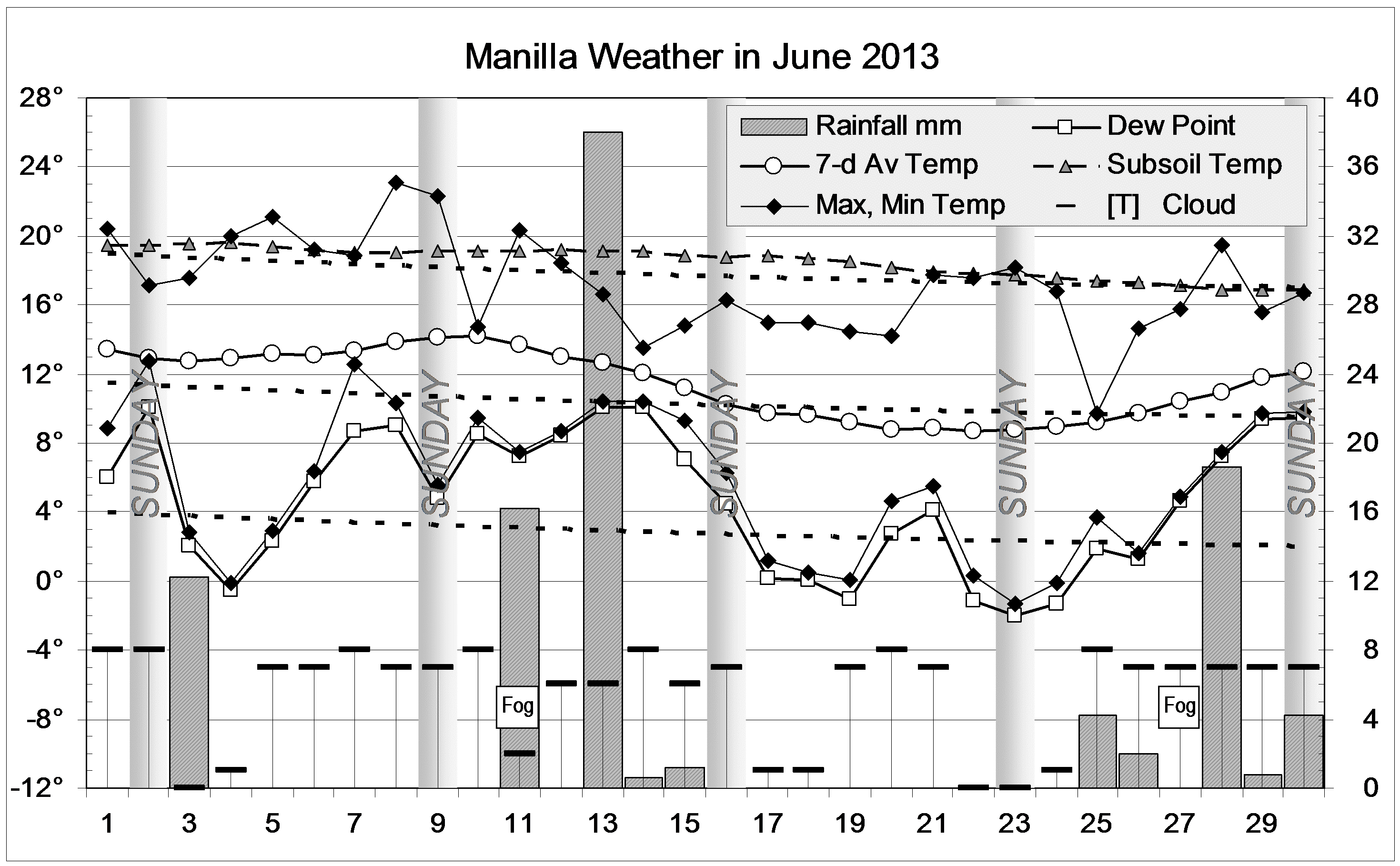
The daily weather log
The first weeks were warmer than usual, including a Queen’s Birthday Saturday that reached a pleasant 23°. In contrast, Tuesday the 25th reached only 9.7° making it the fifth coldest day of the century.
There were hardly any sunny mornings in the month, and most were close to overcast. Cloud kept the nights warm, limiting the number of frosts to only eight. The night of the 7th had a minimum of 12.6°, nine degrees above normal.
The wettest of 10 rain days had 38.0 mm, almost as high as a 38.2 mm reading in June 2008.
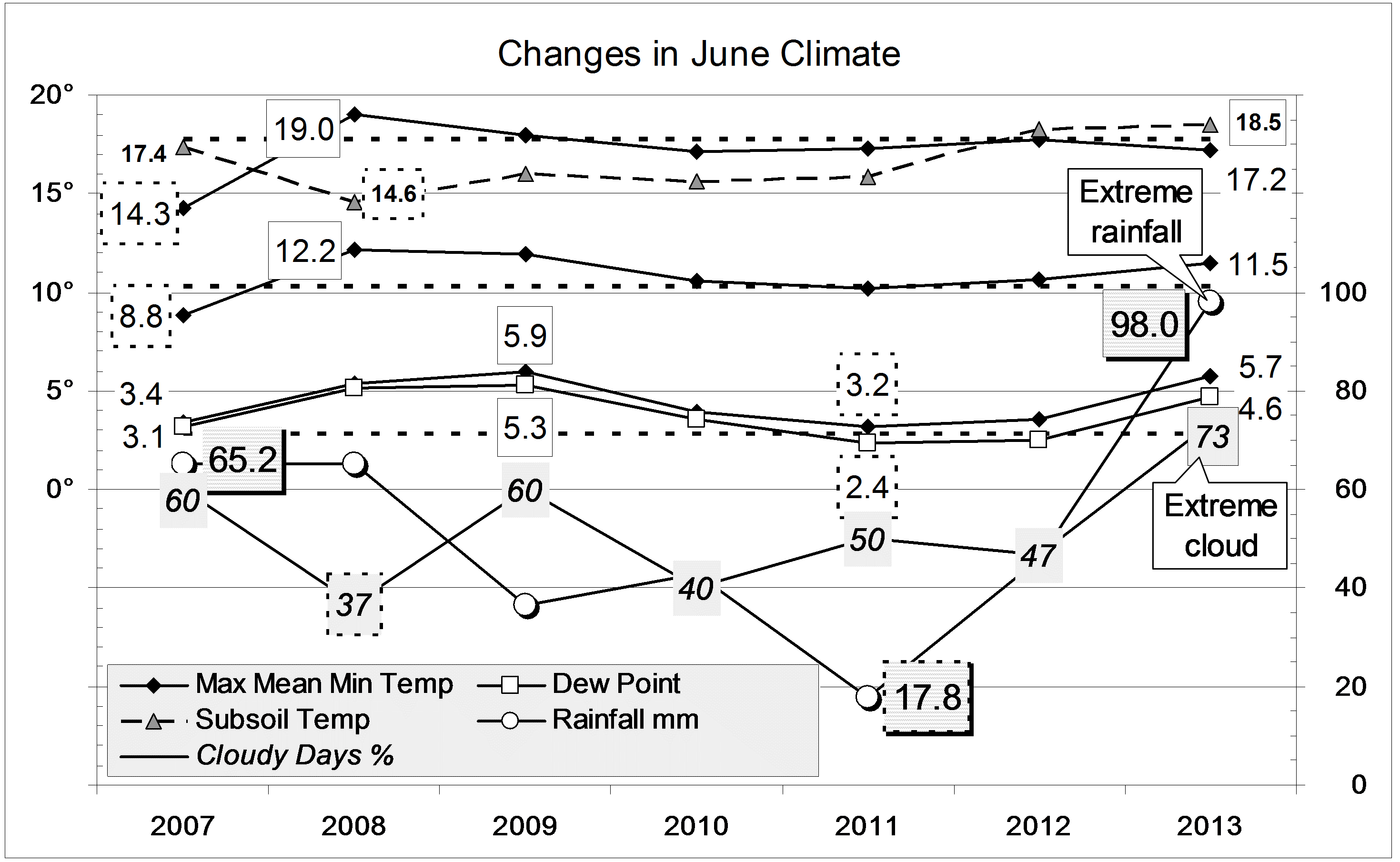
Comparing June Months
Extreme cloudiness and rain lead this month’s climate values. Having 73% of mornings with cloud covering more than half the sky makes this the cloudiest month in the 21st century by far. July 2010 and March 2011 reached only 61%. This month’s figure is over twice the June average of 33% cloudy mornings.
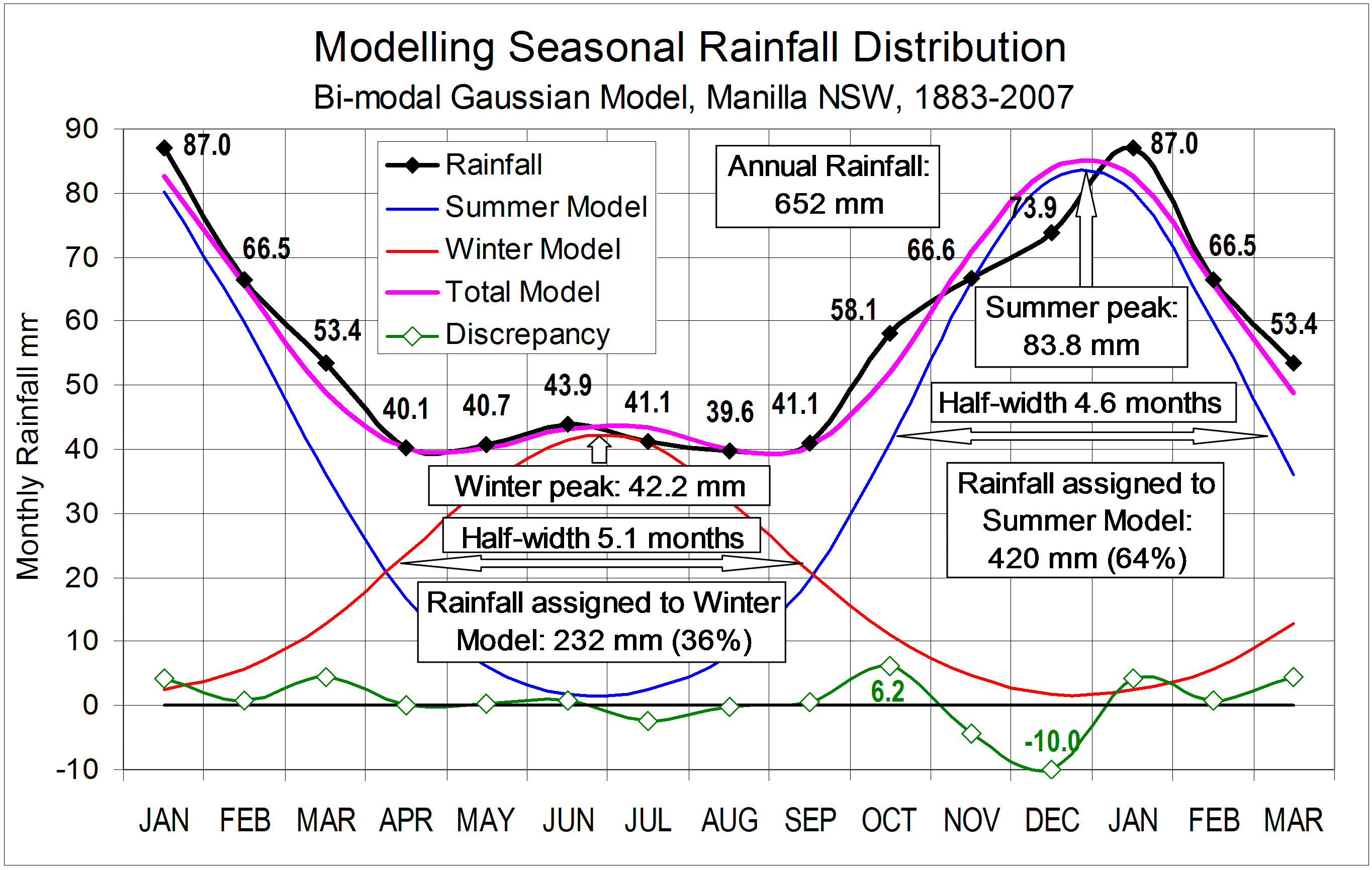
With a rainfall total of 98.0 mm, this is the eighth wettest June in 131 years. The wettest was June 1920, with 173 mm. That was the first of a cluster of four extremely wet Junes, ending with June 1931, that were among the ten wettest. Only eight years ago, June 2005 was the sixth wettest on record, at 109 mm.
This month’s rainfall defers any shortage. Among totals for more than one month, the driest is the 34th percentile for the last three months (Total 3-month rain: “only” 116 mm).
The mean daily maximum temperature, 17.3°, is just 0.5° below normal, but the mean daily minimum, 5.7°, is very high, 2.9° above normal (as in 2005, 2008 and 2009). The subsoil remains very warm.
Data. Rainfall data is from Manilla Post Office, courtesy of Phil Pinch. Temperatures, including subsoil at 750 mm, and other data are from 3 Monash Street, Manilla.
A Seasonal Rainfall Model for Manilla, NSW
At 31 degrees south latitude, Manilla, in eastern Australia, lies between the winter rainfall regime of the westerly belt and the summer regime of the monsoon. Much more rain falls at Manilla in summer than in winter.
On this graph, the rainfall distribution by calendar months is shown by the black line and numbers (mm) . This is the average curve for the 125-year period from the first observations in 1883 up to 2007. For any shorter period the curve is not smooth. This record is scarcely long enough to yield a stable estimate of the seasonal pattern. Continue reading
3-year trends to May 2013
Parametric plots of smoothed climate variables at Manilla
“Still warm; not quite so dry”
May continued warm, but not quite so dry. Skies became cloudy again, and minimum temperature rose back to normal.
Points in red for November 2012 complete fully-smoothed data for spring 2012. They define a reversal of climate. Anomalies of moisture variables (rainfall, cloud, dew point, and (minus) temperature range) peaked in the “drought” sense in September or October. The anomaly of daily maximum temperature peaked (probably) in November, and that of daily minimum temperature peaked later (date uncertain).
The curved red arrows on the first graph emphasise the fact that, for these peaks and troughs, temperature extremes came a month or more after rainfall extremes.
ENSO and this 3-year temperature-rainfall-humidity record
I discussed the match between Manilla climate variation at this time and the El Niño – Southern Oscillation in a post on the weatherzone forum thread “ENSO Discussion 2013”: Post #1195723 of 26 May 2013.
Note: Fully smoothed data – Gaussian smoothing with half-width 6 months – are plotted in red, partly smoothed data uncoloured, and raw data for the last data point in orange. January data points are marked by squares. Blue diamonds and the dashed blue rectangle show the extreme values in the fully smoothed data record since September 1999.

