
In an earlier post I modelled the seasonal distribution of rainfall at Manilla, NSW, as a bi-modal Gaussian distribution with a higher Gaussian peak very close to the summer solstice and a lower one very close to the winter solstice.
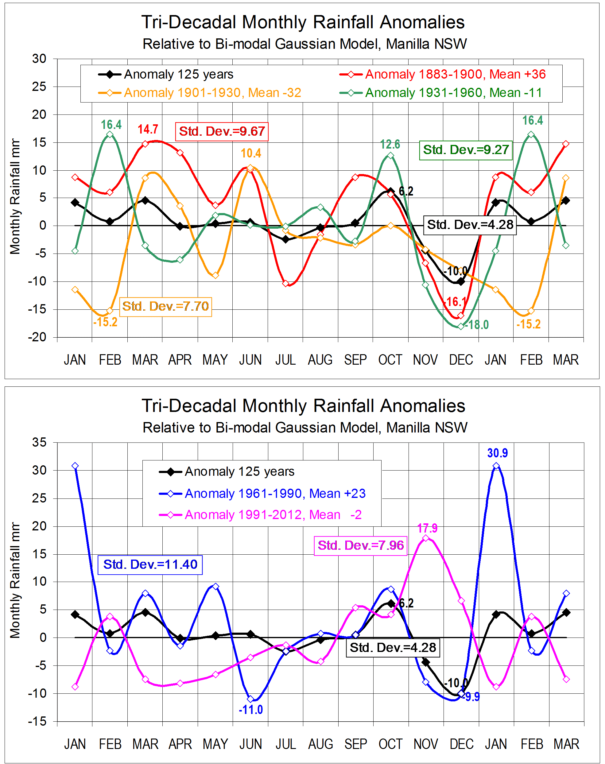
Monthly discrepancies of the 125-year average from the model are small. They are plotted in black on each of the two graphs here. Only two months could not be made to fit the model well: October has 6.2 mm more rain than expected, and December has 10.0 mm less.
The graphs show anomalies from the model for each of five “epochs” of three decades (or less). They are:
1883 to 1900 – “19th Century” (19thC)
1901 to 1930 – “World War I” (WW I)
1931 to 1960 – “World War II” (WW II)
1961 to 1990 – “BoM Normal Period” (BoM)
1991 to 2012 – “21st Century” (21stC)
First, there is some persistence of the whole-record anomalies in the various epochs. The December deficit is greater in 19thC and WW II than in the whole record. It is almost the same in WW I and BoM, and becomes an excess in 21stC. The October excess persists in all epochs except WW I, where there is no anomaly. The excess is greater in WW II.
The higher or lower anomalies of total annual rainfall in each epoch (noted in the legend to the graphs) accords with the curve of long-duration drought and deluge that I have graphed elsewhere.
Taking each epoch in order:
1883 to 1900
This was the wettest epoch, with 36 mm more rain per year than the model. The Standard Deviation of its anomalies, 9.67 mm, is near the mean for the epochs. There are large excesses on the season breaks in March and September, and large deficits near the gaussian peaks in July and December. That is to say, the bi-modal summer-winter model of rainfall distribution is not expressed strongly in this earliest epoch.
1901 to 1930
This was the driest epoch, with 32 mm less rain per year than the model. Anomalies were the least variable, with a Standard Deviation of only 7.70 mm. Relative to the model, rainfall declined from a peak excess in June to a peak deficit in February. In this epoch, a different model may fit better, with an enhanced winter peak and a summer peak reduced and moved towards spring.
1931 to 1960
Annual rainfall was only 11 mm below the model, and the Standard Deviation of monthly anomalies (9.27 mm) was near the mean. This epoch had the greatest enhancement of the October and December anomalies. Anomalies in winter were small, and the greatest excess was in February.
1961 to 1990
This epoch, the one adopted by the Bureau of Meteorology to generate its reference climate normal, is not typical of the 125-year record at this site. Monthly anomalies have the largest Standard Deviation of any epoch (11.40 mm), and the annual rainfall is 23 mm above the model. Both measures relate to the fact that the January rainfall (114 mm) is nearly 31 mm above that in the model. Anomalies in October and June are close to those in the 125-year record, but anomalies are also quite large in May (+) and June (-).
1991 to 2012
The mean annual rainfall since 1990 is practically the same as that for the 125-year record (2 mm less). Total anomalies are small, with a Standard Deviation of only 7.96 mm. The greatest excess is in November, and there are large deficits in January, March, April, and May.
Notes on data from 1999
Citing data from 1999 to date, I mentioned in this “weatherzone” post large monthly anomalies in the same sense as those graphed (in pink) for the 1991-2012 epoch in the months of January, February, May, and November.
In other “weatherzone” posts, beginning here, I have plotted 14-year logs of anomalies of climate variables, including rainfall, for each calendar month. (See note below.)
The actual anomaly values, and the fitted cubic trend lines, show anomalies in the 1991-2012 sense:
January: Trend about 20 mm low; nearly all values low (but two very high).
May: Trend steady at minus 20; nearly all values low.
November: Trend about 20 mm high; all above zero, and very high at the ends.
Note.
The y-axis on these graphs is marked only in degrees. As implied by the legend, the value of monthly rainfall anomaly in millimetres is 20 times the y-axis value in degrees.
 See also:
“Moments of Manilla’s Rainfall History”, a post headed by the graph that is copied on the right
This was originally posted on “weatherzone” on 4th July 2013.
It is posted here dated 22nd July 2013, but made a sticky post in May 2014.
