
At 31 degrees south latitude, Manilla, in eastern Australia, lies between the winter rainfall regime of the westerly belt and the summer regime of the monsoon. Much more rain falls at Manilla in summer than in winter.
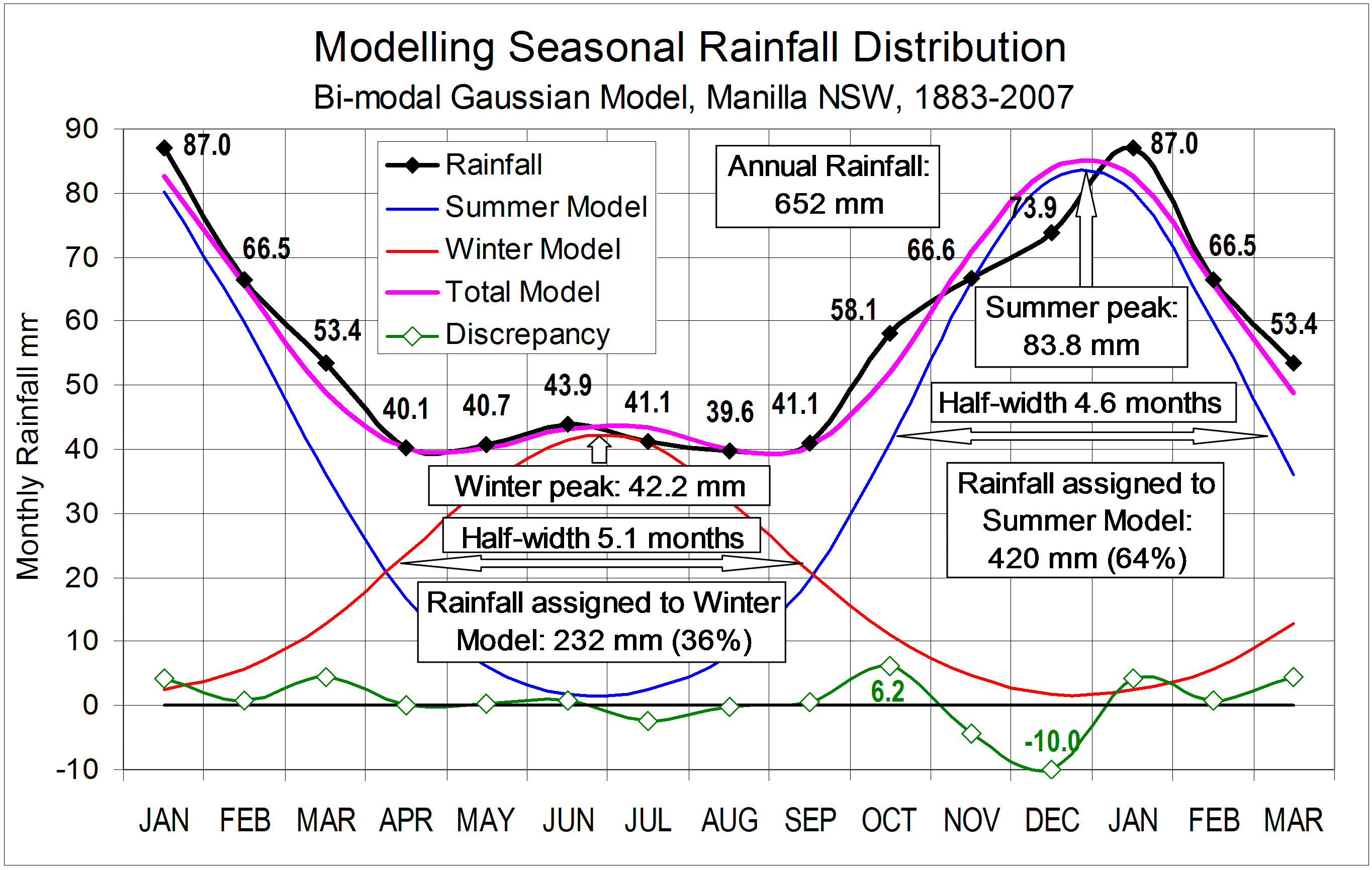
On this graph, the rainfall distribution by calendar months is shown by the black line and numbers (mm) . This is the average curve for the 125-year period from the first observations in 1883 up to 2007. For any shorter period the curve is not smooth. This record is scarcely long enough to yield a stable estimate of the seasonal pattern.
Curve fitting
I have fitted a model of two Gaussian (or normal distribution) curves to these observations. (See Note: Gaussian curves below.)
Because the summer rainfall looks like a bell-shaped curve, I first plotted on the graph a gaussian curve fitted to that.
Noting that the tails of the summer gaussian curve extend for more than twelve months, I graphed three successive years of monthly average data, with three fitted summer curves. Where these curves overlapped, I summed their values.
I then plotted the residual: the monthly data less the summer gaussian curves. This represented the winter rainfall component of the total. Although monthly rainfall is almost constant from April to September, this residual amount was roughly bell-shaped, as I expected. To make the shape of the residual curve more like a gaussian curve I had to adjust the summer curve. In particular I had to make it narrower, so that some part of the rainfall in spring and autumn months could be allocated to a winter curve. I then fitted a second gaussian curve to the residual that represented the winter rainfall. I made a total model curve by summing the summer and winter curves. By further adjusting each of the two seasonal curves, I was able to make the residual values from the total model very small. The net residual value for the whole year was less than 0.5 mm in an annual total rainfall of 652 mm.
Monthly discrepancies of actual rainfall from the gaussian model are plotted at the bottom of the graph. Only two months cannot be made to fit the model well: October has 6.2 mm more rain than expected, and December has 10.0 mm less.
The Nature of the Bi-modal Gaussian Model
The two fitted Gaussian curves peak exactly six months apart, about the 27th of June and 27th of December. That is only six days after the winter and summer solstices. The peaks come much earlier than the dates of annual minimum temperature (10th of July) and maximum temperature (25th of January). [See note: Seasonal lag of temperatures.]
The peak value of the summer curve, 83.8 mm per month is nearly twice as high as that of the winter curve, which is 42.2 mm per month. The winter curve is 11% wider, with a width at half height of 5.1 months versus 4.6 months for the summer curve. Taking areas under the two (wrapped) curves, the summer rainfall curve accounts for 64% (420 mm) of the total annual rainfall (652 mm), while the winter curve accounts for 36% (232 mm).
Implications
As this simple, bimodal Gaussian model fits the actual rainfall distribution so well, it is likely that two distinct sets of processes produce rain at Manilla. In the broadest terms these relate to the mid-latitude westerlies and the tropical monsoon, as is well known. Further study should recognise that the mechanisms, in detail, produce effects concentrated very close to the solstices, and spread randomly around those dates. The spread of the effects due to “summer” processes is wide enough to occur sometimes in mid-winter, and vice-versa.
The model implies that there is no need to seek a mechanism that would produce uniform rainfall from April to September: the uniformity arises from the overlap of two gaussian models.
The large discrepancies that remain, excess rainfall in October, and deficient rainfall in December, perhaps deserve special study.
I will post showing how the rainfall anomalies of calendar months differed from time to time.
[Note added November 2017.
The frequency distribution of annual rainfall is also bimodal
While bimodal distributions of rainfall through the seasons of the year (such as this) have been done for numerous places, I have since identified one of a different kind.
The total record of annual rainfalls since 1883 has a frequency-distribution that is bimodal. Annual rainfall values near 650 mm occur less frequently than those near 550 mm or 750 mm. I have posted this result here.
The only similar case that I have found so far is Salt Lake City, UT. I have not seen an analysis of that bimodality, either.]
Note: Seasonal lag of temperatures.
(25/08/2018)
The word “dates” links to a post in a “weatherzone” forum. That post has had its graphs removed. The relevant material is copied here:
There is a seasonal lag. (See Wikipedia.)
This makes the minimum temperatures occur later than the winter solstice and maximum temperatures occur later than the summer solstice. Manilla has the pattern noted in Wikipedia:
“In mid-latitude continental climates, [the lag] is approximately 20-25 days in winter and 25-35 days in summer.”
To judge by Wikipedia, Manilla’s winter lag is unusually short.
Manilla’s winter lags (from June 21) are:
Daily max: 17 days;
Daily mean: 19 days;
Daily min: 22 days;
Subsoil (at 750 mm depth); 33 days.
Manilla’s summer lags (from December 21) are:
Daily max: 31 days;
Daily mean: 35 days;
Daily min: 42 days;
Subsoil (at 750 mm depth); 46 days.
For air temperatures, these summer lags are close to 1.9 times winter lags.
For subsoil temperature, the summer lag is only 1.4 times the winter lag.
Manilla’s normal temperature cycle [added 7/10/2018]
Manilla’s dates of expected highest and lowest air temperatures during the year are marked on every “Weather” graph that is included in a monthly weather report in this blog. Each graph has curved dashed lines showing the “Normal” temperatures (Maximum, Mean, and Minimum) for each day of the year. The highest and lowest values in the annual cycle are marked on these curves. They occur on these dates:
Highest daily maximum temperature (34.04°): January 20-21 (lag 31 days);
Highest daily mean temperature (26.19°): January 25 (lag 35 days);
Highest daily minimum temperature (18.44°): January 31 – February 1 (lag 42 days);
Lowest daily maximum temperature (16.91°): July 8 (lag 17 days);
Lowest daily mean temperature (9.35°): July 10 (lag 19 days);
Lowest daily minimum temperature (1.78°): July 13 (lag 22 days).
My Normal temperature curve for Manilla uses temperatures observed in the decade from March 1999, fitted to a harmonic model.
Note: Gaussian curves. The spreadsheet application Microsoft Excel has a function “NORMDIST” which gives the normal or Gaussian distribution curve. It has an input called “cumulative” which must be set to “FALSE” to give the bell-shaped normal density function curve. I experiment with different constants on both axes of the curve to achieve a fit.
This was originally posted on “weatherzone” on 2nd July 2013.
It is posted here dated 20th June 2013, but made a sticky post in May 2014.

Gary, Thanks.. I’m certain that you should submit your detailed research for award of Ph.D. It covers climate from the Pacific Ocean to your house. Seriously -why not? Regards John W.
Thanks, John. It’s all a bit scrappy, but I think it is worth saying, nevertheless.