
Parametric plots of smoothed climate variables at Manilla
“Suddenly very wet”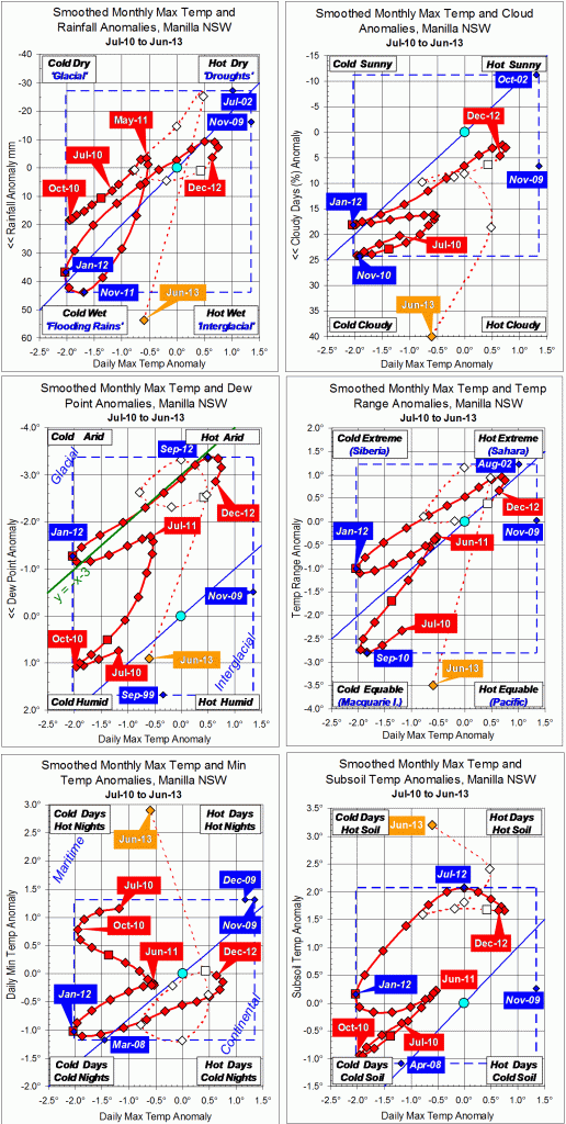
While days were only a little cooler than normal in June, moisture variables were extremely high. Rainfall, cloudiness and daily temperature range went beyond the blue lines. Cloudiness reached a record for this data set.
Both daily minimum temperature and subsoil temperature were also very high.
The fully-smoothed data point for December 2012 shows a drift towards normal from the mild drought of October.
Note:
Fully smoothed data – Gaussian smoothing with half-width 6 months – are plotted in red, partly smoothed data uncoloured, and raw data for the last data point in orange. January data points are marked by squares.
Blue diamonds and the dashed blue rectangle show the extreme values in the fully smoothed data record since September 1999.

Wow, so much detail. What do the words ‘maritime’ and ‘continental’ mean on the fifth chart?
Thanks for your interest.
In general terms, the diagonal axis on each graph from the top right corner to the bottom left corner shows how the Australian climate swings between “droughts and flooding rains”.
http://www.dorotheamackellar.com.au/archive/mycountry.htm
The other diagonal axis means something different on each graph. On the fifth graph, daily minimum temperature versus daily maximum temperature, the top left corner has maxima not much higher than minima: that is what happens in sea-side or “Maritime” climates. The bottom right corner has maxima very much higher than minima: that is what happens in “Continental” places that are a long way from the sea. For a time in late 2010, Manilla (200 km from the sea) had a Maritime climate, as if it had been moved much nearer to the coast.
Pingback: Rainy March 2014. MANILLA ..NSW Australia | CRIKEY !#&@ ...... IT'S THE WEATHER CYCLES