Profile of an Extreme Drought

Rainfall vs Maximum temperature, 2002 droughtAt Manilla, NSW, there was a drought in 2002 that was extreme, but brief. There have been no other extreme droughts at Manilla in the 21st century. The current drought is not as bad (yet).
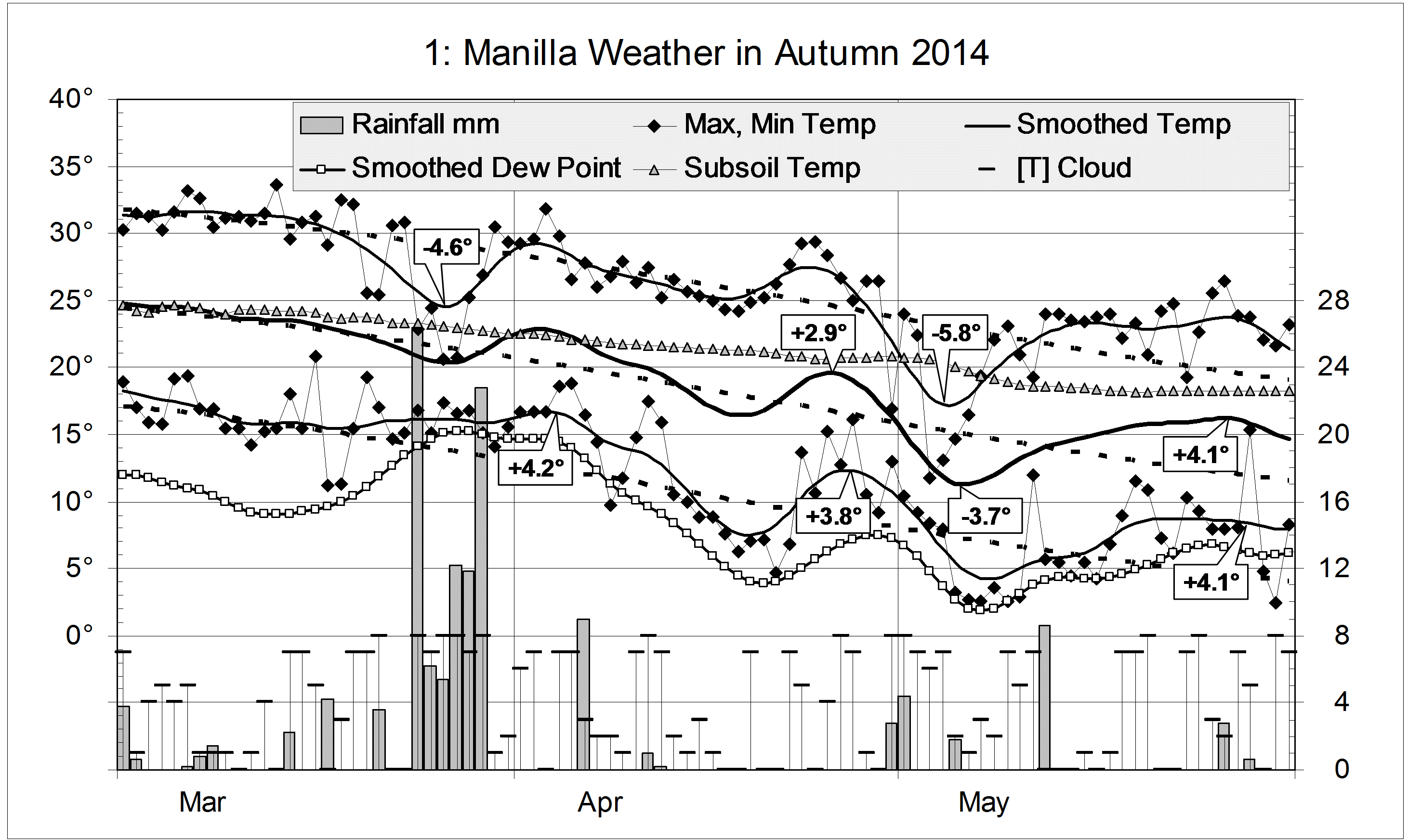
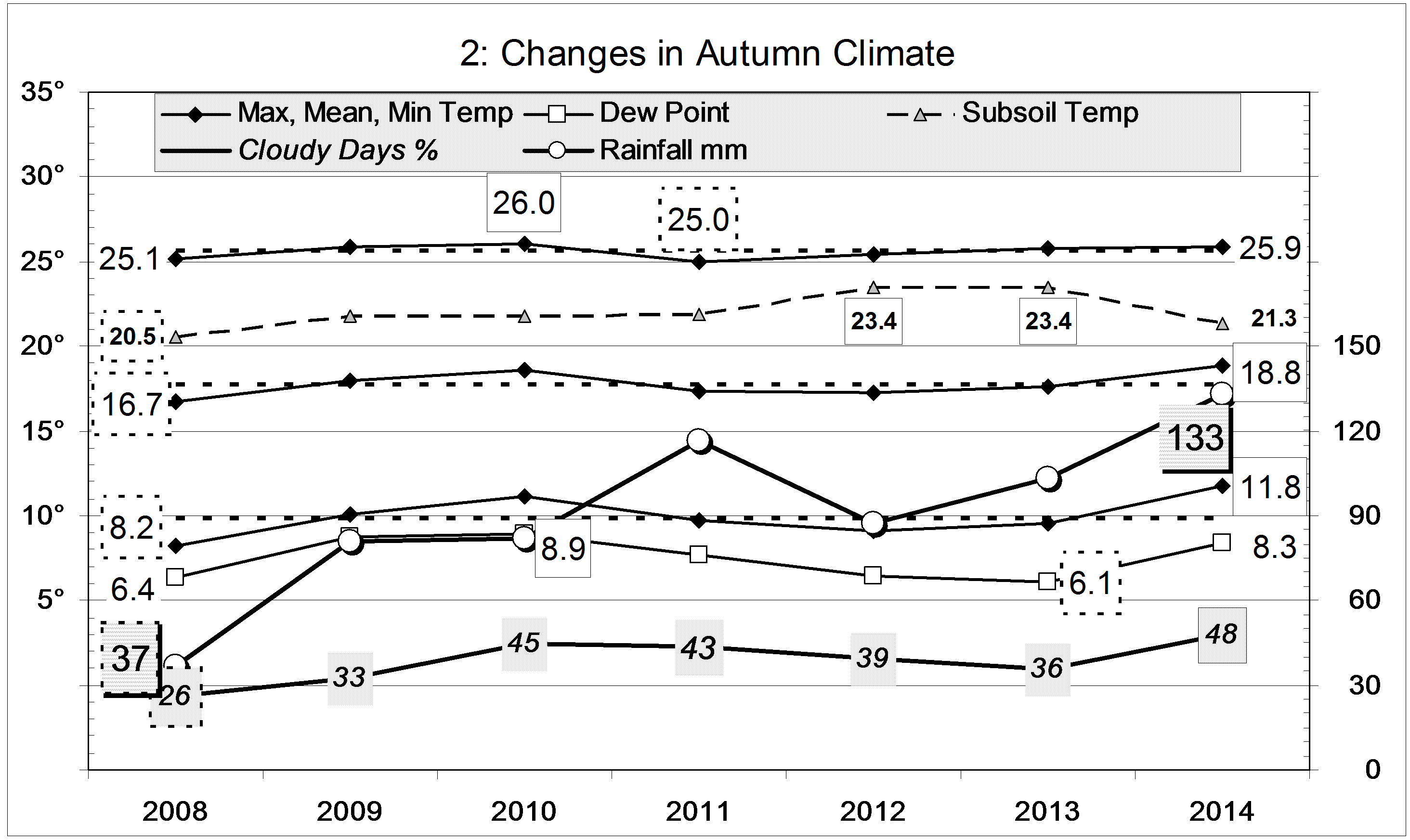
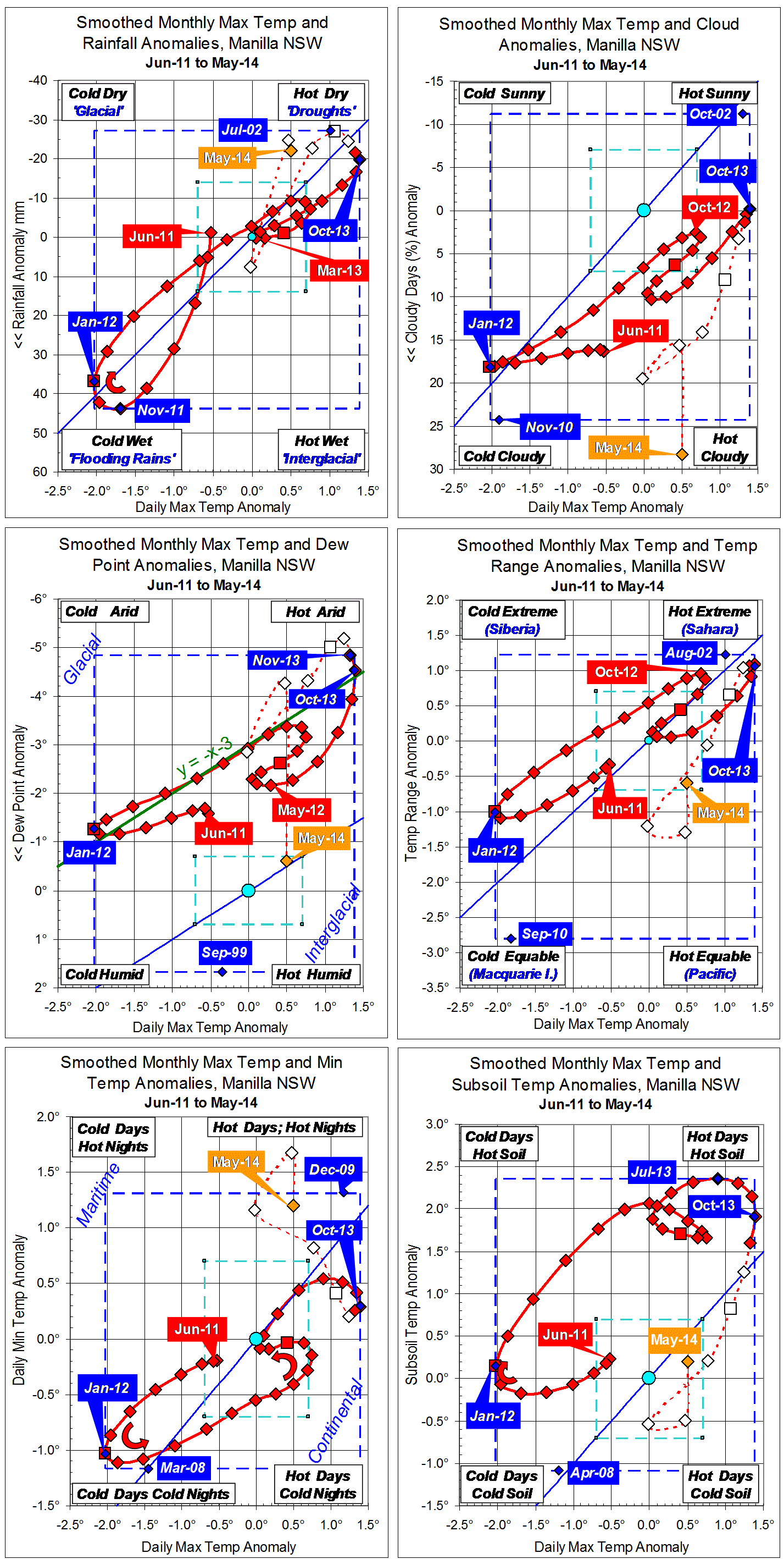
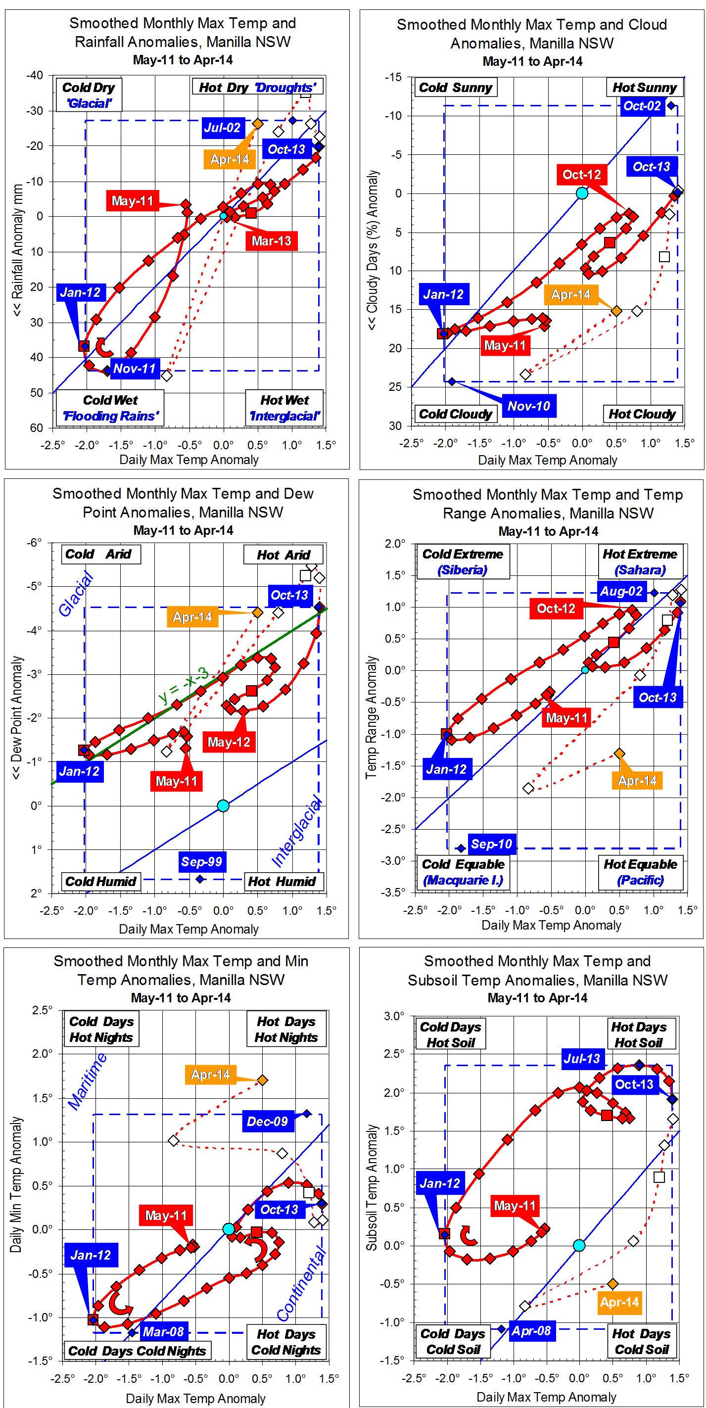
The first graph shows a profile of the 2002 drought. Low rainfall is at the top, and hot days are on the right. Droughts, with low rainfall and hot days, will be near the top right corner. Normal climate is marked by a rectangle (coloured aqua (aqua)) in the middle.
The climate in these months moved into drought and out of it. January 2001 (Start) had perfectly normal climate with no drought, and so did February 2003 (Finish). Rainfall first became lower than normal after January 2002, and reached a minimum 27 mm below normal in July 2002. Rainfall returned to the normal range by December 2002. Day-time temperature went above the normal range in May 2002, reached a peak 1.3 degrees above normal in September-October 2002, and fell back into the normal range in January 2003. For rainfall lower than normal, the drought lasted ten months: for days hotter than normal, it lasted eight months. In this drought, the time of lowest rainfall came two to three months earlier than the time of hottest days.

(There is more detailed analysis of  the 2002 drought in a post dated September 2004.)

Graphs showing the progress of the drought as rainfall shortages are in the post “The 2002 rainfall shortages at Manilla”.

The loop on the graph shows this drought as a simple event with a beginning, a middle, and an end. Droughts are not usually seen to be so simple. This graph is made using two “tricks”: anomalies and smoothing. You must judge whether you trust them to describe the drought as it happened.

Continue reading

Autumn 2014 cloudy with warm nights

Austral bluebells in autumn

Autumn bluebells

There were two severe cold spells in late March and early May. Days were several degrees colder than normal, and the daily temperature range was narrow. To compensate, there were three spells of very warm nights in early April, late April, and late May. The last of these also had warm days and lasted a fortnight.

Weather log autumn 2014

Rain fell on 23 days (twice the normal number), totalling 132.8 mm. Most of it (84.8 mm)  fell in the week beginning on the 24th of March. The autumn total is on the 125-year average, and in the 58th percentile.

In autumn seasons from 1999, this was equal warmest with 2007, but nights (11.8°) were by far the warmest, 1.3° above normal. The mean daily temperature range, at 14.1°, was the narrowest, and the percentage of cloudy days (48%) the highest. All these point to a more moist (maritime) climate than does the rainfall or the dew point.

Climate for autumn 2014


Data. Rainfall data is from Manilla Post Office, courtesy of Phil Pinch. Temperature, including subsoil at 750 mm, and other data are from 3 Monash Street, Manilla.

3-year trends to May 2014

Parametric plots of smoothed climate variables at Manilla
“Drought status not clear”

Trends to May 2014

May data (orange)

Raw data for May 2014 give mixed signals on whether the drought is fading. Daily maximum temperature is now on the high limit of the normal range and rainfall again well into the “drought” range. However, other variables do not agree: skies were very cloudy, and dew point and daily temperature range were back to normal.

Fully smoothed data (red)

The spring months (SON) of 2013 are now fully smoothed, with some variables showing a drought peak in that season.
Smoothed daily maximum temperature anomaly peaked in October, reaching a record high of +1.39°, beating +1.34° in November 2009 and +1.30° in September-October 2002. Through spring the smoothed rainfall anomaly decreased; it may have reached a minimum in January. Dew point also decreased, the smoothed anomaly reaching a new record low of -4.85° in November, and likely to reach a minimum in December.
Cloudiness reached a minimum in October, and daily minimum temperature and subsoil temperature anomalies had reached maximum values earlier, in July.

Note:
Fully smoothed data – Gaussian smoothing with half-width 6 months – are plotted in red, partly smoothed data uncoloured, and raw data for the last data point in orange. January data points are marked by squares.
Blue diamonds and the dashed blue rectangle show the extreme values in the fully smoothed data record since September 1999.

Normal values are based on averages for the decade from March 1999. They appear on these graphs as a turquoise (turquoise) circle at the origin (0,0). A range of anomalies called “normal” is shown by a dashed rectangle in aqua (aqua). For values in degrees, the assigned normal range is +/-0.7°; for cloudiness, +/-7%; for monthly rainfall, +/-14 mm.


May 2014 cloudy with warm nights

The daily weather log

Yellow berries  on a White Cedar in May.

White Cedar in May

May began cold: the 3rd was the 2nd coldest May day of this century, at 11.7°. By the 6th, the 7-day mean temperature was more than four degrees below normal. Within a week, the weather became warm and, by the 25th, the 7-day mean was more than four degrees above normal. The night of the 26th (15.3°) was the 3rd warmest May night of the century. For the first time, May had no frosts at all, and more than half the mornings were cloudy (>4/8 cloud). There were five rain days, two more than usual.

Weather log May 2014

Comparing May months

Air temperatures and the dew point were not far from normal. However, as the second graph shows, they are higher than in May months of recent years, such as 2012. Skies were extraordinarily cloudy, but the subsoil temperature was no longer high.
The total rainfall of 18.2 mm is in the 33rd percentile for May. While this is well below the long-term average of 41 mm, it is on the average for the last 15 years. Taking rainfall totals for more than one month, only the two-month total (31 mm) is a serious shortage (9th percentile). The fifteen-month total (585 mm) is in the 12th percentile. Other totals have higher percentile values, and most totals for 36 months or more are above normal. Pools still survive in Greenhatch Creek.

Climate May 2014


Data. Rainfall data is from Manilla Post Office, courtesy of Phil Pinch. Temperatures, including subsoil at 750 mm, and other data are from 3 Monash Street, Manilla.

3-year trends to April 2014

Parametric plots of smoothed climate variables at Manilla
“Are we coming out of drought?”

Trends to April 2014

After a very cool moist March, raw values of climate anomalies for April 2014 are nearly all back near the (slightly smoothed) values for February. However, neither month was as hot or dry as December or January.
Fully-smoothed values for October 2013 show the deepening drought. That month set a new 21st century record for smoothed daily maximum temperature anomaly of +1.39°, beating the value of +1.35° set in November 2009. It also set a new low record for dew point anomaly of -4.53°, far more arid than the record set the previous month: -3.53°.
These curves show clearly that the climate (at this site) consistently became warmer and drier through the two years from spring 2011 to spring 2013, except for a brief time of reversal in the six warm-season months from October 2012 to March 2013.

Note:
Fully smoothed data – Gaussian smoothing with half-width 6 months – are plotted in red, partly smoothed data uncoloured, and raw data for the last data point in orange. January data points are marked by squares.
Blue diamonds and the dashed blue rectangle show the extreme values in the fully smoothed data record since September 1999.