Warm February 2011 with a very wet day

The daily weather logWeather log February 2011.

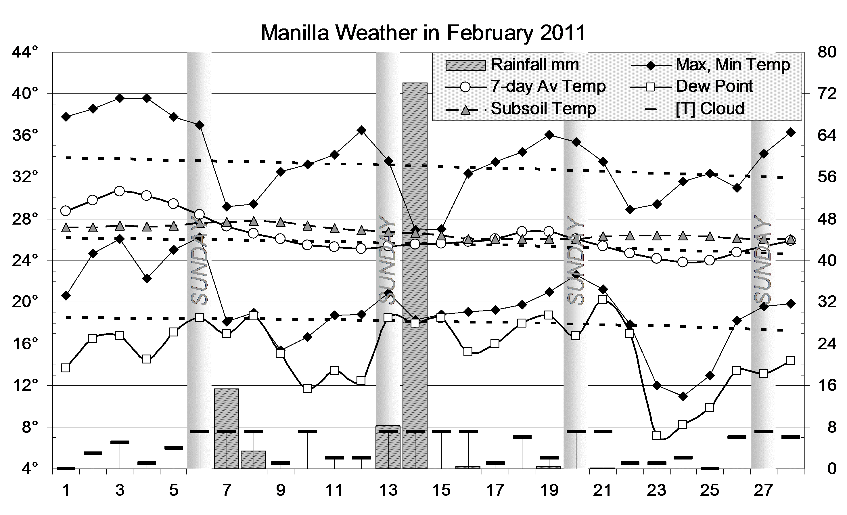
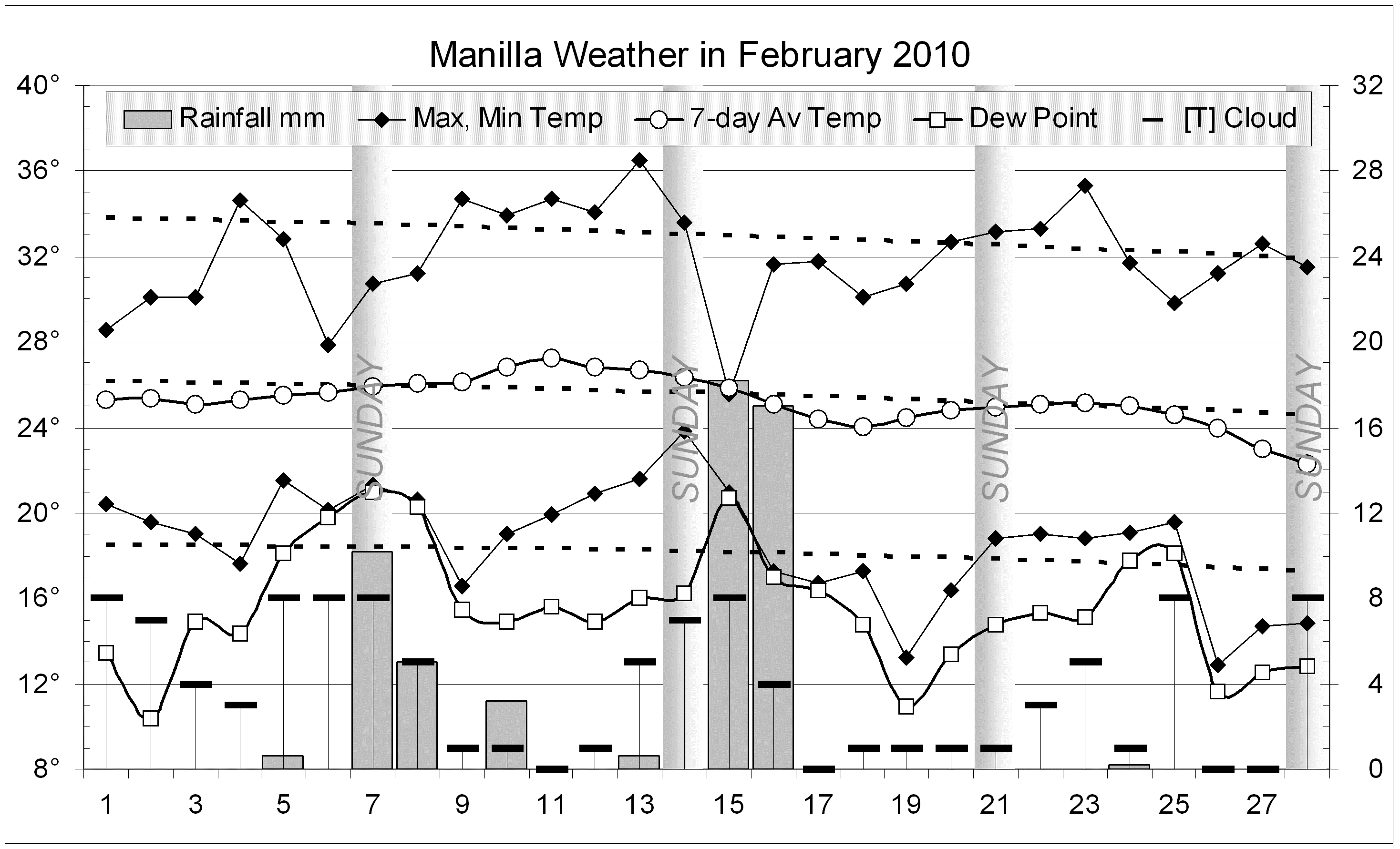
Several Mondays and Tuesdays this month were cool, while most other days were warm. Nights in the first week were warm, lifting the seven-day average. Three nights in the last week were very cool, at a time of very dry air.
Rain on the 7th (15.4 mm) ended a three-week dry spell, but really heavy rain was recorded on the 14th. That reading of 74.2 mm was the 29th heaviest daily fall in more than a century.

 Comparing February monthsClimate February 2011.

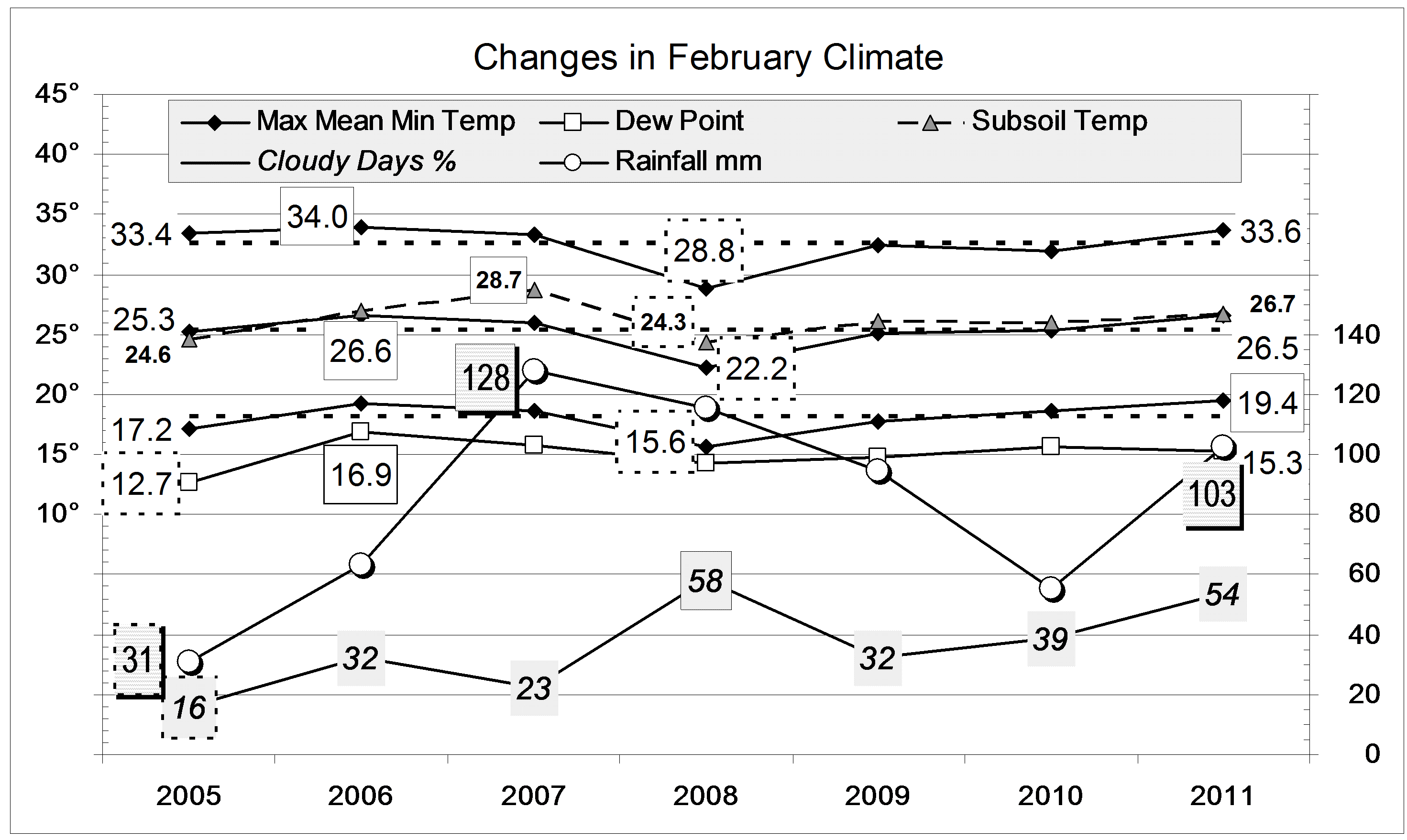
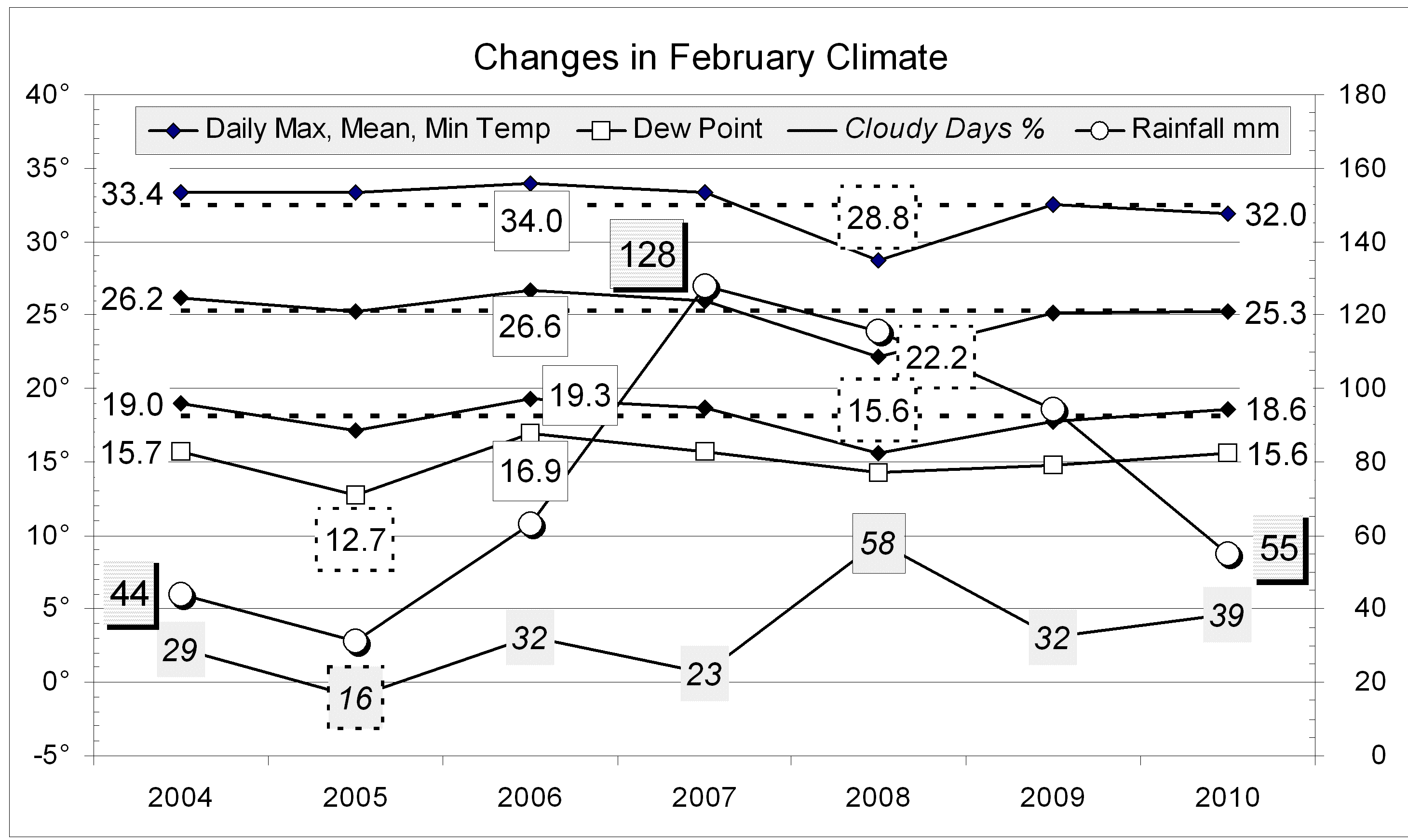
Mean maximum, mean, and minimum temperatures and mean soil temperature were all about a degree above average. The mean Dew Point was average, and cloudiness high (54%).
The rainfall of 102.6 mm is in the 77th percentile for February, far above the long-term average of 67 mm. Rainfall totals for groups of months are very high: above the 70th percentile for all periods up to 15 months, and above the 90th percentile for periods of 4-, 5-, and 6-months.


Data. Rainfall data is from Manilla Post Office, courtesy of Phil Pinch. Temperatures, including subsoil at 750 mm, and other data are from 3 Monash Street, Manilla.


February 2010: two rainy spells

The daily weather logWeather log February 2010

While last February was very hot then very cold, this February had no such weather. The only cool day was the 15th, at 25.6°.
Rain came in two short spells, totalling 55 mm in eight rain days (usually seven).

 Comparing February monthsClimate February 2010

This month’s average readings were normal. There were a few more cloudy mornings than usual, and the daily temperature range (13.3°) was down by one degree.
The rainfall total (55.0 mm) was in the 55th percentile for the month; above the February median (middle value) of 46 mm, but below the long-term February average of 67 mm. Rainfall totals for groups of months remain fairly high. The greatest rainfall shortage is the 12-month total (456 mm), which is in the 13th percentile.


Data. Rainfall data is from Manilla Post Office, courtesy of Phil Pinch. Temperature and other data are from 3 Monash Street, Manilla.


February 2009: swelter and shiver

The daily weather log

Weather log February 2009

February days began hot (37.8°), and got hotter. The 9th reached 40.9°: that was 7.5° above normal, and the hottest day of the summer. At 20°, nights were unpleasantly warm, but it is normal for the first week of February to have the hottest nights of the year (18.4°).
The daily maximum on the 14th was an amazingly cool 17.8°, that is, 23.1° lower than five days before! The reading was 15.2° below normal. On that day, half of NSW, excluding only the borders on the east, south and west, had daily maximum temperatures more than 12° below normal.
A wet spell from the 11th to the 17th brought most of the month’s rain.At Manilla the highest reading was 51.2 mm on the 15th.
The month ended dry, with temperatures normal, except that nights became cool.

 Comparing February months

Climate February 2009

This month’s climate was normal, if rather wet. Other Februaries on the graph vary in every way:

February 2005 was sunny, dry, and not humid;
February 2006 was hot and humid;
February 2007 was very rainy;
February 2008 was very cloudy and very cold.
The rainfall total (94.5 mm) was in the 75th percentile for the month; well above the February average of 67 mm. This neatly makes up the January shortfall. Rainfall totals for groups of months remain very high. The 6 month total (525 mm) is in the 92nd percentile, and more than 200 mm above the median value. Totals are still above the median for all periods up to 72 months, with the exception of the 36-month total, and that has now risen to the 46th percentile.


Data. Rainfall data is from Manilla Post Office, courtesy of Phil Pinch. Dew point values before August 2005 are from Tamworth Airport 6 am data supplied by the Bureau of Meteorology. Temperature and other data are from 3 Monash Street, Manilla.


Cold, cloudy wet February 2008

The daily weather logWeather log February 2008

Reading the 7-day mean temperatures, the month started near normal, but cooled to unusually low figures by the end of the first week – five degrees down! For a week from the 19th it was only two degrees below normal, then back to four degrees down at the end of the month.
Days were particularly cool, running about 29° instead of 33°.  However, the coolest days were not extreme.
The warmest day, Friday the 22nd, reached only 35.5°. The following morning was the warmest at 26.1°.
Dry air arrived from the south on the 24th, with a Dew Point of only 5.8°.
Rain fell frequently until the 19th, with the 6th being the wettest day (32 mm). The 29th was also very wet. There were nine rain days, totalling 115.6 mm. This is nearly twice the long-term February average of 66 mm.
Very few mornings were “Fine” (with no cloud).

 Comparing February months

Climate February 2008

This was by far the coldest of the last nine Februaries, by day and by night. The mean daily maximum of 28.8°, the mean daily mean of 22.2°, and the mean daily minimum of 15.6° were all well below average, by 3.7°, 3.1°, and 2.5° respectively.
The contrast with the last two years is stark: the days in February 2007 were 4.5° hotter, and those in February 2006, 5.2° hotter than this month. (Note added: This cooling was global.)
With 58% of mornings exceeding 4 octas of cloud, this February, along with December 2007 (58%) and June 2007 (60%) was one of the cloudiest months in nine years. Most months in Manilla have about 30% cloudy mornings.

This month’s rainfall of 116 mm is in the 81st percentile of February totals. (Last February’s 128 mm was the seventeenth wettest February on record.) Taking rainfall totals for more than one month, every total up to 12 months is very high: above the 70th percentile.


Data. Rainfall data is from Manilla Post Office, courtesy of Phil Pinch. Dew point values before August 2005 are from Tamworth Airport 6 am data supplied by the Bureau of Meteorology. Temperature and other data are from 3 Monash Street, Manilla.