Winter 2010 wet, with few frosts

 An episode of maritime climate

I have posted this seasonal report for winter 2010 on the front page, as a sticky post, to show how the climate of that season was not normal. It was not the average temperature or the rainfall that were unusual. The sky was very cloudy, the humidity very high, and the daily temperature range very low. The climate was equable, as one would expect at a place near the sea: a maritime climate. More in the footnote*

Weather log winter 2010

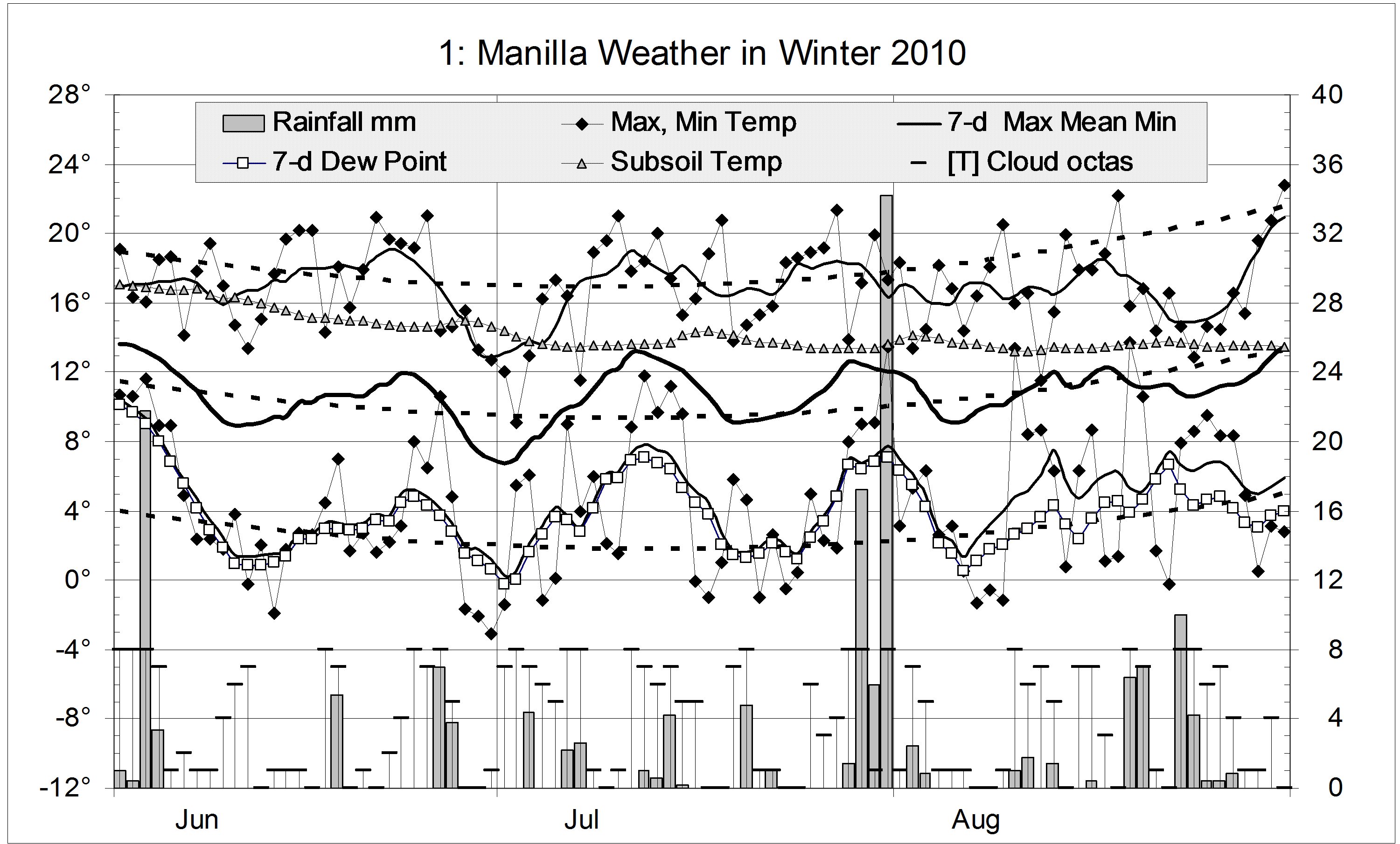
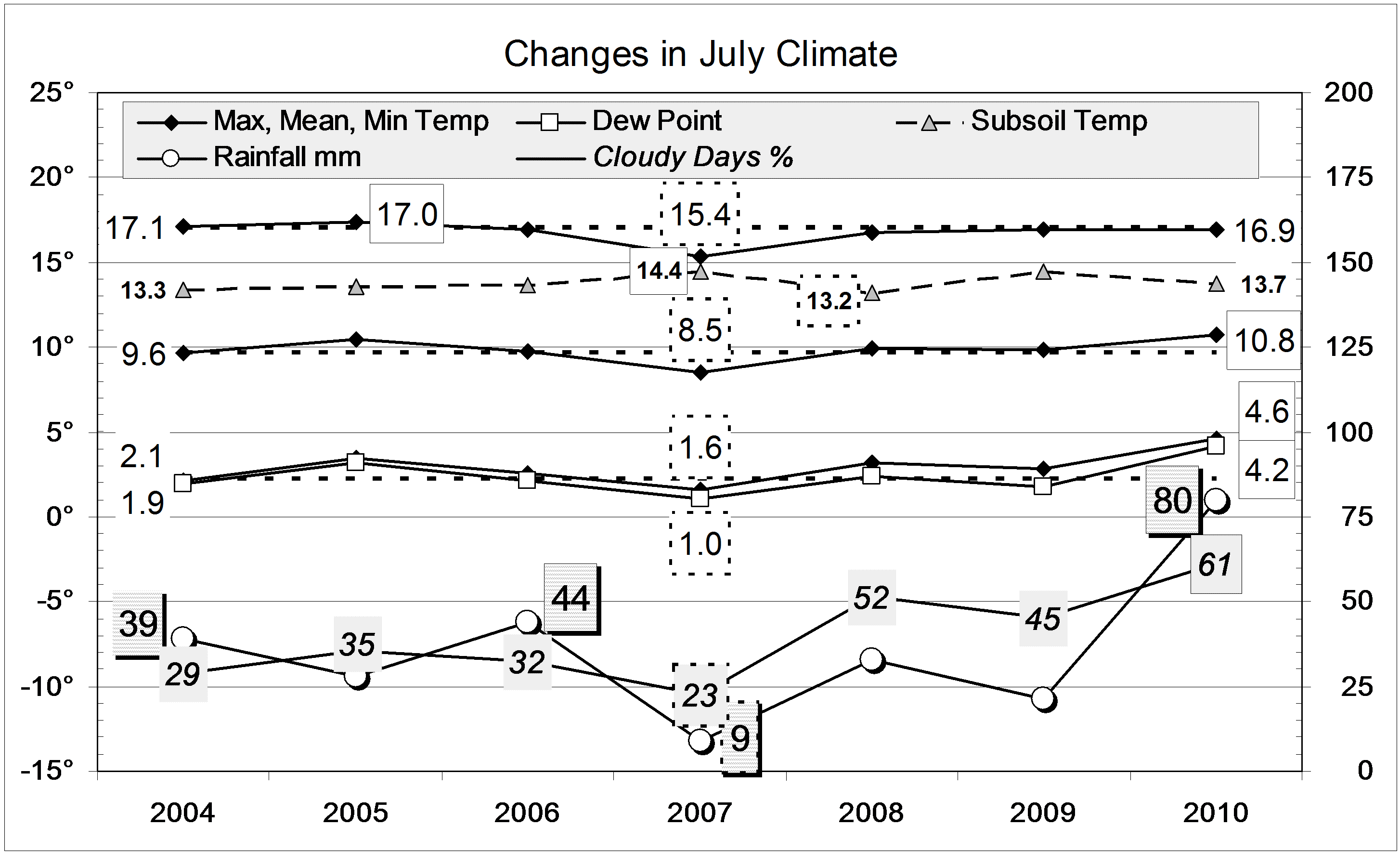
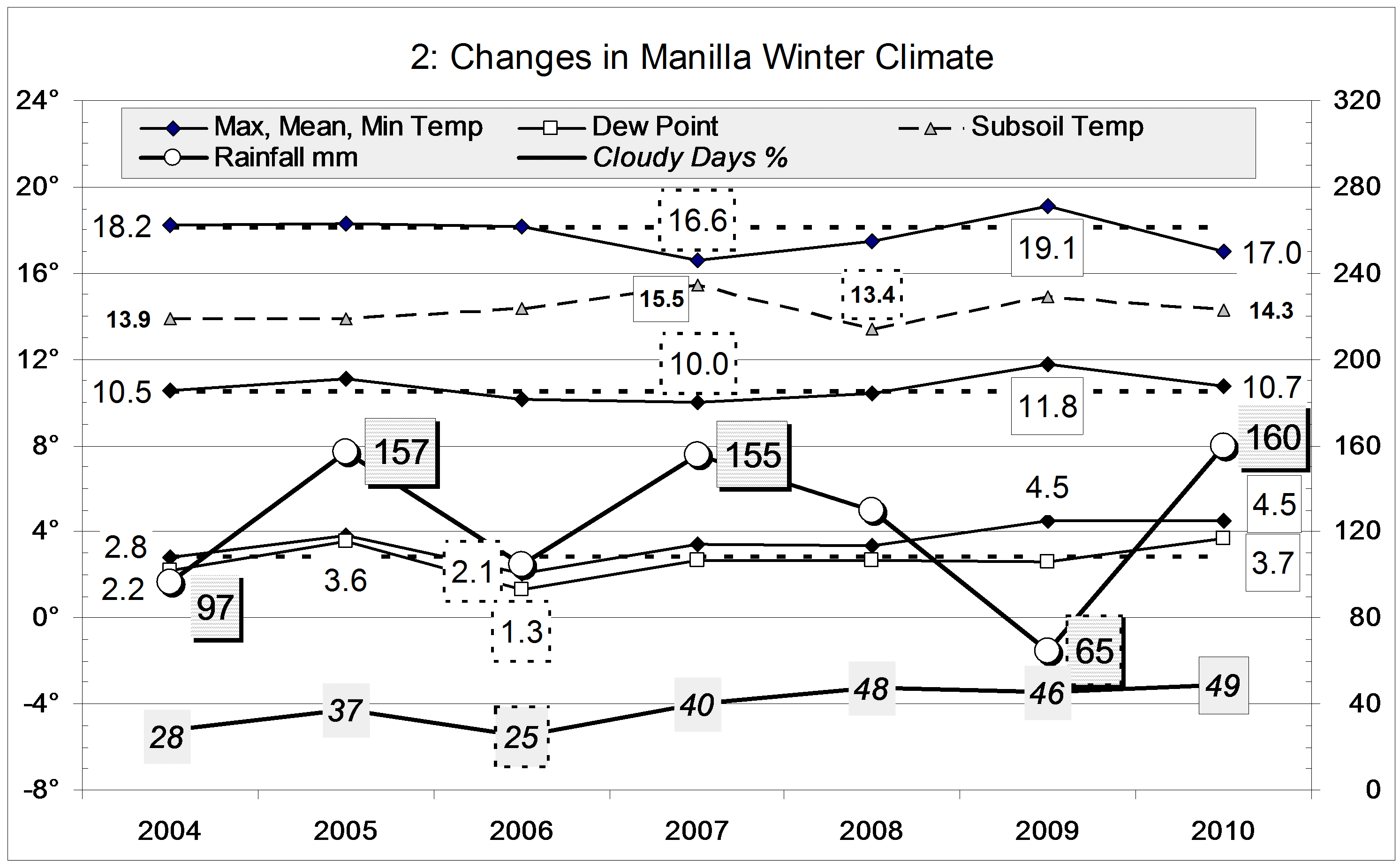
Temperatures this winter changed little from month to month. June, July and August each had temperatures near the season averages: maximum 17.0°, mean 10.7° and minimum 4.5°. Warm days were rare: only 11 exceeded 20° (usually 25). This winter was even less frosty than the last, with only 32 frosts (usually 44). The lowest minimum was -3.1°.
There were 33 rain days, about twice the usual number.


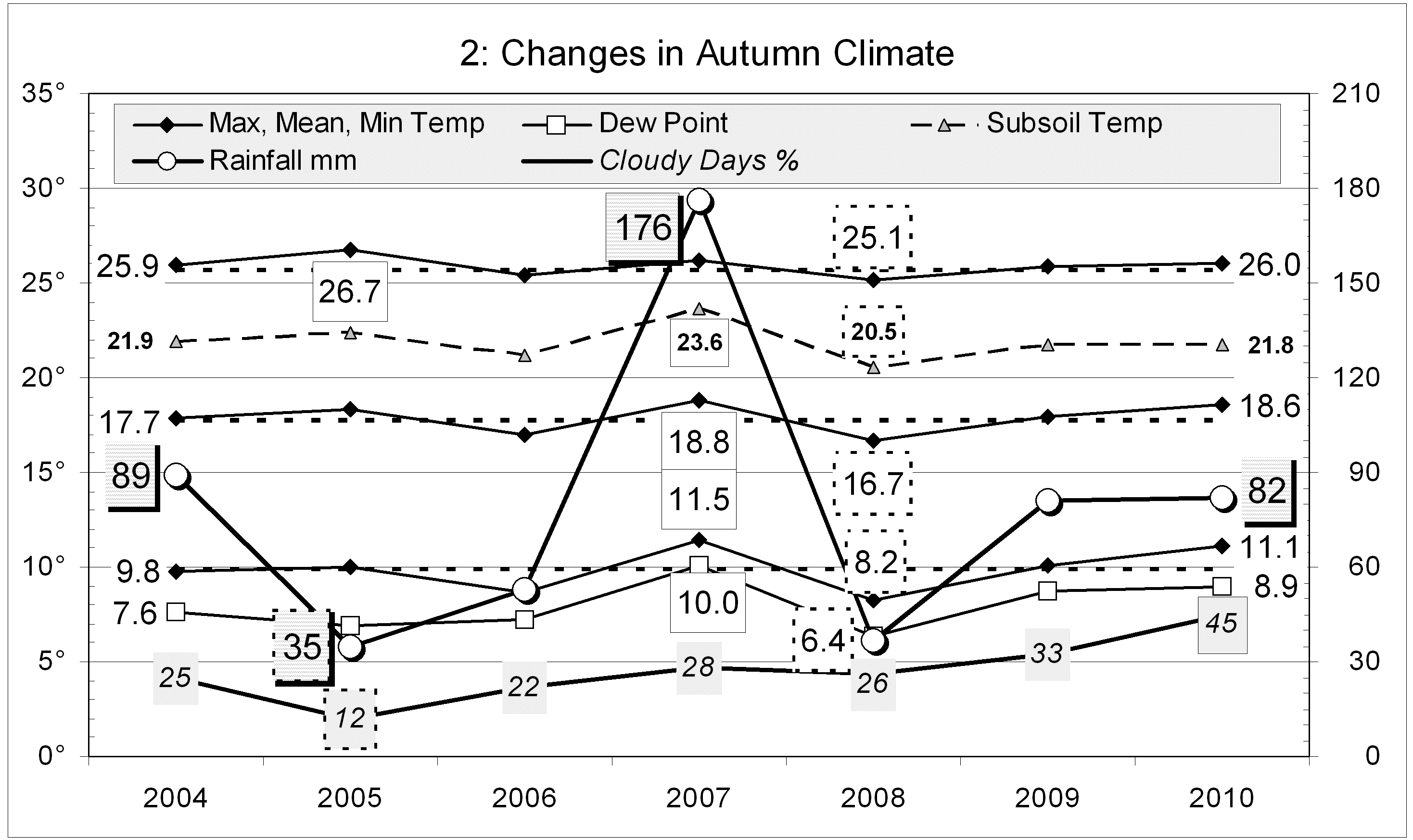
In terms of daily mean temperature, this winter was normal, However, cool days and warm nights made the daily temperature range (12.5°) narrower than in any winter in the 12-year record. It was also the cloudiest, at 49% cloudy mornings. Manilla’s climate became much more cloudy three years ago, when the average number of cloudy mornings in a month jumped suddenly from nine to twelve (See also these other graphs.). Humidity, as shown by early morning Dew Point was also very high this winter. All these changes reflect a more maritime climate, as on the coast.
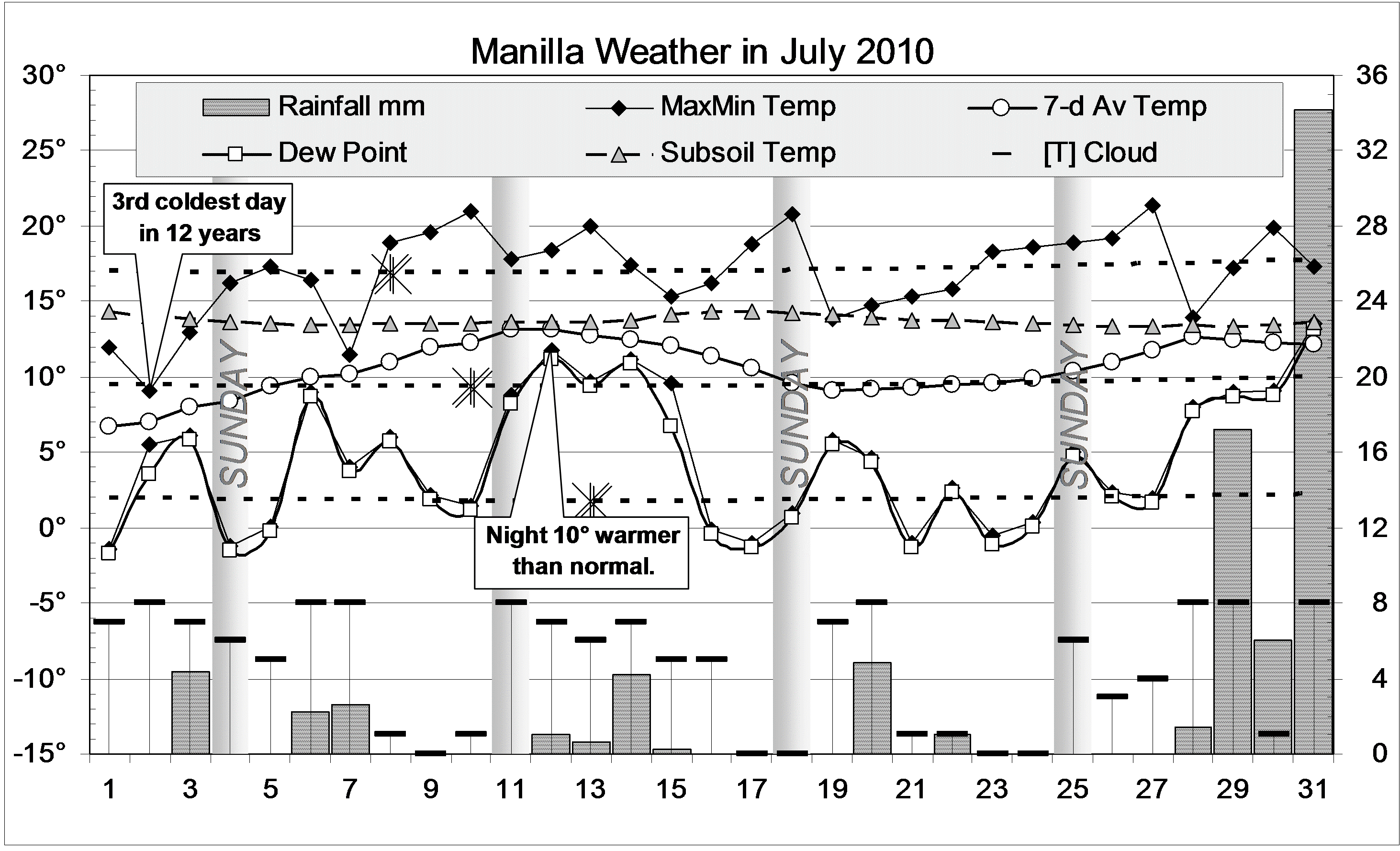
Each month would have had rainfall close to average, were it not for one reading of 34.2 mm at the end of July. The total of 160 mm is in the 70th percentile, like that of the wet winters of 2005 and 2007.

Climate winter 2010

*Footnote. The nature of this episode is clear on the 3-year graphs of climate trends, such as that for August 2011. The top left graph shows that, in June, July, and August 2010, rainfall was a little high and daily maximum temperature rather low. The bottom left graph shows the main anomaly: daily minimum temperature remained extremely high while daily maximum rapidly fell, reaching a record low value by October 2010. From July to November that year the difference between daily maximum and daily minimum temperature was some three degrees less than normal.
The middle graph on the right shows directly that the daily temperature range in those months was at record low (narrow) values.

Data. Rainfall data is from Manilla Post Office, courtesy of Phil Pinch. Temperatures, including subsoil at 750 mm, and other data are from 3 Monash Street, Manilla.

July 2010 Rain Twice Average

The daily weather logWeather log July 2010 Manilla

July began cold. The 2nd, with a maximum temperature of 9.1°, was the coldest July day in the record from 1999. The only two colder days were: 8/06/07 (8.8°), and 20/06/07 (8.3°).

Two warm spells followed, marked mainly by nights that were very warm for mid-winter. The minimum on the 12th (11.8°) was 10° above normal, and that on the 31st (13.5°) was 11.3° above normal. Colder nights included twelve mild frosts, the fewest on record.
There were 13 rain days spread through the month. The reading of 17.2 mm on the 29th was topped by 34.2 mm on the 31st.

“Normal Temperature”

Each Manilla monthly weather graph has dashed curves to show the temperatures that are normal for each day of the year. They are harmonic curves matching 10-year averages from March 1999. On this July graph, the lowest values are marked with a double “X”. Winter cold is due to lack of heat from the sun, which yields least heat on the 21st of June (the winter solstice). On that day the sun is lowest and shines the shortest time. However, it takes many days for the air to cool down. On average, the coldest day in Manilla comes 17 days later (July 8th) and the coldest night 22 days later (July 13th). Manilla’s coldest day and night follow the solstice with an unusually short lag time. (See Wikipedia: Seasonal lag.)

See the monthly weather report for January 2010 for the highest normal temperatures of the year. These relationships are shown on a graph here.

Comparing July monthsClimate July 2010 Manilla

Due to cloudy nights, the mean daily minimum temperature (4.6°) was by far the highest in the 12-year record for July, and 2.4° above the average. Because the mean maximum temperature was normal (16.9°), the mean average temperature was also high (10.8°). The mean daily temperature range (12.3°) was the narrowest in the July record.

Very high humidity was shown by a mean early morning Dew Point of 4.6°, higher than any since July 1999 (5.7°). The percentage of cloudy mornings (61%) was the highest, not only for July months, but for any month in this record. Nineteen mornings were completely overcast.
The rainfall of 79.8 mm is in the 90th percentile for July: only 12 July months have been wetter. It is close to double the long-term average of 41 mm. As a result, total rainfalls for the last two months and three months are now above the median. No serious rainfall shortages remain. The worst shortages are far from serious: the 15-month and the 9-year totals are both in the 14th percentile.


Data. Rainfall data is from Manilla Post Office, courtesy of Phil Pinch. Temperatures, including subsoil at 750 mm, and other data are from 3 Monash Street, Manilla.

Extremely Cloudy Autumn 2010

Weather log autumn 2010

There were dry spells in mid-March, mid-April and early May. Each had very low humidity and mainly sunny weather. The first two had very warm days, but the third had cold nights. The final week brought one third of the season’s rain, with overcast skies, very high humidity, and very warm nights.
In all, there were 16 rain days, totalling 82.0 mm. No rain day exceeded 10 mm.
The subsoil temperature (750 mm depth) fell as is normal for autumn in Manilla, pausing for a few days after each peak in air temperature. By the end of the season, the subsoil was as warm as the air during the heat of the day.


This year, each of the months March, April and May was the cloudiest in the 11 year record. As a result, this autumn (45%) was also the cloudiest. Of 92 mornings, 41 were cloudy (>4/8 cloud): nearly twice the usual number of 23. The previous highest (last year) had only 30 cloudy mornings.
Due to the cloud, the daily temperature range (14.9°) was a degree narrower than usual. As the mean temperature was rather high, the result was a daily minimum temperature a degree above normal. Other temperatures, and the Dew Point, were near normal.
The total rainfall of 82 mm is again on the 30th percentile for autumn. It is 31 mm below the autumn median rainfall (113 mm).

Climate autumn 2010

Data. Rainfall data is from Manilla Post Office, courtesy of Phil Pinch. Temperatures, including subsoil at 750 mm, and other data are from 3 Monash Street, Manilla.

Damp end to cloudy May 2010

The daily weather logWeather log May 2010

Dry weather with warm days and cool nights lasted most of the month. On the 13th the early morning Dew Point of -6.3° set a record for low humidity in May. The seven-day average temperature was quite low in the second week. Nine mild frosts (usually 6) all came about this time. By the 25th there had been only 57 mm of rain in 14 weeks: an average of barely 4 mm per week. A serious rainfall shortage was developing, despite months of cloudy weather.
Late in the month nights became very humid and warm. Mornings had fog on the 18th and 22nd and mist (visibility one kilometre) on the 27th and 31st. Three days had more than 5 mm of rain. In all, the month had 8 rain days, totalling 28.0 mm.

 Comparing May monthsClimate May 2010

This was the cloudiest May in the 11-year record. The mean maximum temperature and the mean average were normal. The mean minimum was up, reducing the daily temperature range, and the mean Dew Point was down.
The rainfall of 28.0 mm is near the median for May (51st percentile). It is below the long-term average of 40 mm, but no May total has beaten the average since 1998! Rainfall totals for groups of months show just one serious shortage. The 15-month total (538 mm) is now down to the 7th percentile.

Subsoil Temperature

Both graphs now include subsoil temperature measured at 750 mm depth. There the temperature barely changes during a day. It changes slowly with the seasons. Usually it ranges from 26° in February to 14° in July.
As observed in Manilla, the  subsoil temperature does not relate to the normal average temperature of the air in a simple way. In May, it stays about five degrees warmer; in other autumn and winter months it is less than five degrees warmer. In spring and summer it is almost the same as the normal average air temperature.
In autumn 2007 the subsoil temperature was nearly two degrees warmer than usual; in autumn 2008 it was one degree cooler than usual. This is a puzzle, because the average air temperature did not change so much.


Data. Rainfall data is from Manilla Post Office, courtesy of Phil Pinch. Temperatures, including subsoil at 750 mm, and other data are from 3 Monash Street, Manilla.


Late March 2010 Warmth

The daily weather logWeather log March 2010

After three early rain days, there was a long spell of warm sunny weather. From the middle of the month, all temperatures rose well above normal. The maximum on the 20th went to 35.7° and the minimum on the 28th to 20.6°. A rain-band in the district in the last days yielded only 8 mm, bringing the month’s total to 31.8 mm in four rain days.

 Comparing March monthsClimate March 2010

While the average maximum and Dew Point readings were near normal, the mean and minimum readings were very high. There were more cloudy mornings than any March in the 11-year record, and the daily temperature range (14.1°) was narrow – not much wider than the 13.5° recorded in March 2007. This month was very like that one, but the rain then was four times as heavy.
The rainfall of 31.8 mm is in the 43rd percentile for March, below the long-term average of 51 mm. There are no serious shortages in rainfalls for groups of months. The worst are the 12-month total of 480 mm (16th percentile) and the nine-year total of 5388mm (12th percentile), which is just under 600 mm/year. (The 125-year average is 652 mm/year, and the median (50th percentile) is 627 mm/year.)


Data. Rainfall data is from Manilla Post Office, courtesy of Phil Pinch. Temperature and other data are from 3 Monash Street, Manilla.