August 2011: rain still scarce

The daily weather logWeather log August 2011.

There were warm sunny days early and late in the month. Otherwise, days were often cold and cloudy, with a bit of rain. Of four foggy mornings, the 28th had fog that kept visibility below 800 metres until 11 am.
Temperatures were never far from normal. Two years ago, August 2009 had one daily maximum (31.8°) which was 11.4° above normal and one daily minimum (18.2°) which was 14.0° above normal.
The highest rainfall reading was quite low: 8.2 mm, recorded on the 18th. There were ten rain days, four more than usual, but the total was only 30.8 mm.

 Comparing August monthsClimate August 2011.

Mean temperature readings were above normal by half a degree. The mean early morning Dew Point (1.9°) was 0.6° lower than normal, indicating low humidity.
With only nine frosts (below +2.2° in the Gill screen), this was the least frosty August of thirteen.
Fifty-five percent cloudy mornings equalled the August record, set in 2008.
The rainfall of 30.8 mm is fairly low, in the 44th percentile for August. Rainfall totals for 3, 4, 5 and 6 months have percentile values lower than 10, making them serious rainfall shortages. Totals for larger groups of months continue to be near normal. The 12-month total (691 mm) is well above the median, being in the 61st percentile.


Data. Rainfall data is from Manilla Post Office, courtesy of Phil Pinch. Temperatures, including subsoil at 750 mm, and other data are from 3 Monash Street, Manilla.


Cool days in August 2010

The daily weather logWeather log August 2010 Manilla

August had no extremes. Only four days exceeded 20° (usually thirteen days), and only ten nights were frosty (usually fifteen). The subsoil temperature failed to rise during the month, ending at 13.5°, which is 1.0° cooler than normal.

Rain fell on 13 days, an August record for the decade, but the highest reading was only 10 mm.

Comparing August monthsClimate August 2010 Manilla

The mean daily maximum temperature (26.5°) was the lowest for November on this 12-year record. The mean daily temperature range (12.4°) was (with November 2008) a record low value.

Mean subsoil temperature (20.4°) was the lowest since November 1999. The month ended with subsoil temperature (then 22.2°) trailing only 10 days later than its usual date. It had begun the month 22 days late.
There were more cloudy mornings (53%) than in any November on this record.
The rainfall of 105.4 mm is in the 84th percentile for November, far above the long-term average of 67 mm. Totals for groups of months up to 15 months are now all above the median, as is the thirty-year total.


Data. Rainfall data is from Manilla Post Office, courtesy of Phil Pinch. Temperatures, including subsoil at 750 mm, and other data are from 3 Monash Street, Manilla.

August 2009 HOT and dry

The daily weather log

Weather log August 2009

Nearly all the days of August were warmer than normal. While half the nights were cold, some others were very warm. A regional heat wave struck from the 22nd to the 25th, setting records for exceptionally high temperature at Manilla and many other places. The maximum on the 23rd (31.8°) was 11.4° above normal, beating +10.5° set on 11/10/02. The minimum on the morning of the 25th (18.2°) was 14.0° above normal, beating +13.1° set on 23/9/03.
Sixteen minimum temperatures qualified as frosts (usually 15) but the coldest was no lower than -1.4°. Dew Points were low, often far below the air temperature, making the air unpleasantly dry.
Very light rain fell on four days, to a total of 6.8 mm. By the end of the month, there had been forty days without 5 mm of rain.

 Comparing August months

Climate August 2009

Mean daily maximum, mean, and minimum temperatures were far above normal for the month, by 3.1°, 2.5°, and 1.7° respectively. It was the warmest August in the 11-year record, and more than 4° warmer than the previous August (2008).
Manilla is very short of rain. Serious shortages (below the 10th percentile) are found not only in the August total (7 mm) but in totals for the 2, 3, 4, and 5 months to date. Worse, the 6-month total (145 mm) is a severe shortage (in the 4th percentile): it is 163 mm less than the median 6-month rainfall (308 mm). Rainfall totals for longer periods are good. The worst is the 8-year total that includes the 2002 drought: it is in the 24th percentile.


Data. Rainfall data is from Manilla Post Office, courtesy of Phil Pinch. Temperature and other data are from 3 Monash Street, Manilla.


3-year trends to August 2008

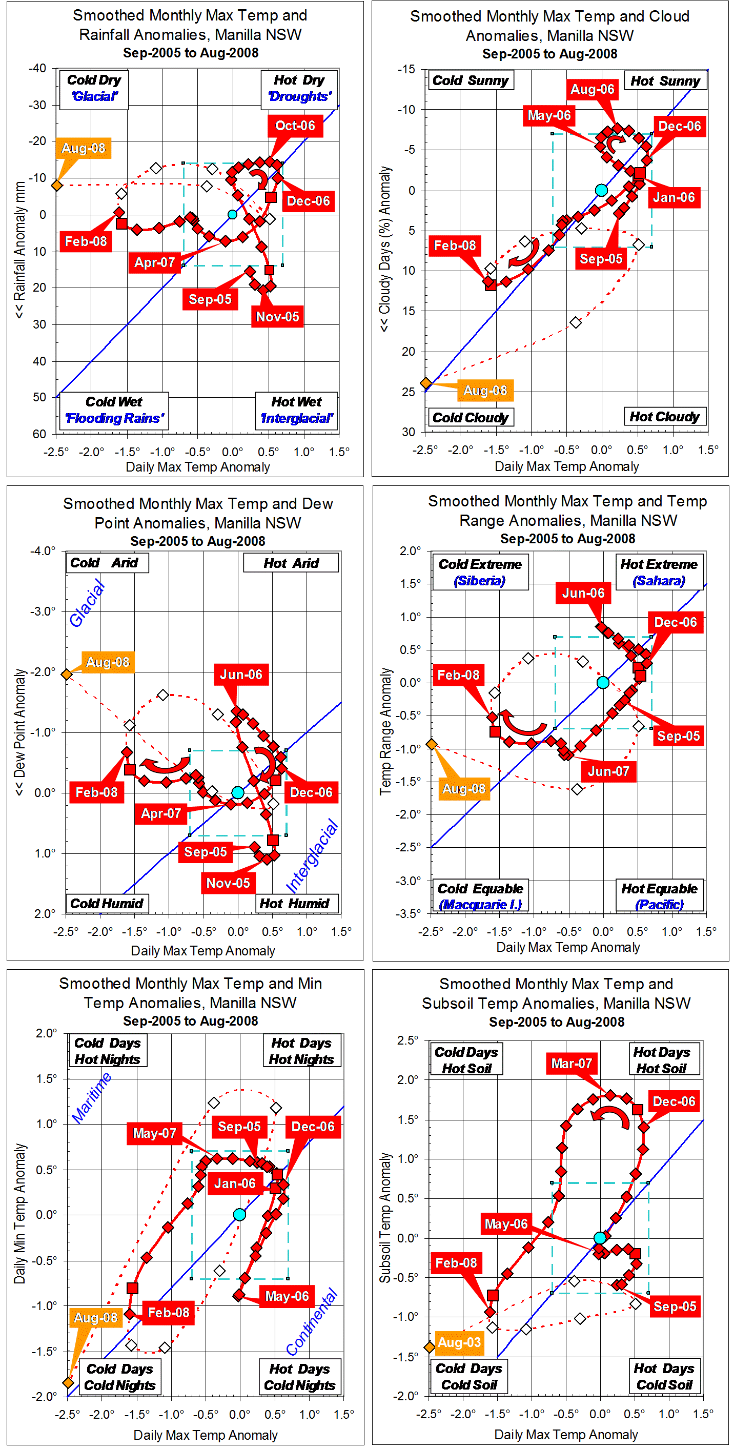
Parametric plots of smoothed climate variables at Manilla
“Years with unusual trends”

Trends to August 2008

These graphs, ending with raw data for August 2008, show fully-smoothed data from September 2005 to February 2008. They include all months of the calendar years 2006 and 2007.
Smoothed daily maximum temperature anomaly (X-axis on all graphs) began 2006 high in the “normal” range, fell to normal by June, and rose again to +0.63°  in November and December. It then fell from high to very low through 2007, reaching the record low value of -1.61°  by February 2008. (Note added: This record low maximum temperature anomaly stood for only 19 months, until September 2010.)
Smoothed rainfall anomaly peaked at +20.6 mm in November 2005, fell rapidly to -11.7 mm in June 2006 and slowly to -14.6 mm in October 2006. It rose again to just above normal by February 2007, and changed little in the following year.
Smoothed percent cloudy mornings followed a similar course to that of rainfall but, as temperature fell through 2007, cloudiness (unlike rainfall) increased, as is normal,  along the blue trend-line.
(Note added in May 2014: Although the minimum value of the cloudiness anomaly in August 2006 (-7.7%) is less negative than the record minimum in August 2002 (-11.3%) (or even than the minimum in February 2005 (-9.1%)) it is more negative than any later value. No smoothed negative values at all were recorded in almost seven years between February 2007 and October 2013.)
Smoothed dew point anomaly also followed a similar course to that of rainfall but, unlike cloudiness, actually declined as temperature fell during 2007. Temperature range anomaly moved like dew point anomaly.
Daily minimum temperature mainly varied in the same sense as daily maximum temperature, but at a higher rate. As an exception, from January to June 2007, it rose slightly as maximum temperature fell. That moved the curve towards a more “maritime” climate for the rest of the time. Subsoil temperature anomaly moved in a similar pattern.

Unusual trends

Through the years 2006 and 2007 shown here, the climate moved as much along the axis from top left to bottom right, as along the usual axis from top right to bottom left. It departed from the typical Quasi-biennial oscillation of “droughts and flooding rains”*. (Note added: The extreme negative maximum temperature anomaly of February 2008 was the only one on this record that was not linked to an extreme positive rainfall anomaly.)
(Note added concerning global temperature: At this time there was a sudden major cooling in mean air temperature, both locally and globally. This linked post  shows that, when 37-month averages of global and local values are plotted, mean temperature fell from a peak in April or May 2006 to a trough in October 2007, breaking the global warming trend. The global (GISS) value fell by 0.074° (and the Manilla value by 0.48°). The connection is enigmatic. The unusual trends shown here do not match the dates of the cooling event, but come mainly before or after it.)

* By arrangement with the Licensor, The Dorothea Mackellar Estate, c/- Curtis Brown (Aust) Pty Ltd.

Note:
Fully smoothed data – Gaussian smoothing with half-width 6 months – are plotted in red, partly smoothed data uncoloured, and raw data for the last data point in orange. January data points are marked by squares.
Normal values are based on averages for the decade from March 1999. They appear on these graphs as a turquoise (turquoise) circle at the origin (0,0). A range of anomalies called “normal” is shown by a dashed rectangle in aqua (aqua). For values in degrees, the assigned normal range is +/-0.7°; for cloudiness, +/-7%; for monthly rainfall, +/-14 mm.

(Note added in May 2014: A much later post titled “3-year trends to May 2010” is the first of a consecutive series of parametric plots, updated monthly at the time of observation and originally posted elsewhere.
This earlier data was not edited in this form at the time.
To display all existing fully-smoothed data points at least once, I have prepared these back-dated posts in the same format for:
“3-year trends to August 2002” which includes smoothed data September 1999 to February 2002, covering the calendar years 2000 and 2001.
“3-year trends to August 2004” which includes smoothed data September 2001 to February 2004, covering the calendar years 2002 and 2003.
“3-year trends to August 2006” which includes smoothed data September 2003 to February 2006, covering the calendar years 2004 and 2005.
“3-year trends to August 2008” (this post) which includes smoothed data September 2005 to February 2008, covering the calendar years 2006 and 2007.
In these back-dated posts the anomaly values depend on climate normals that are based on the decade ending February 2009, and were thus not available until after that date. I have written the posts as if they were available at the time.
In places I have written some “Notes added in May 2014” (like this) commenting on how values observed at that time relate to more recent events.)


August 2008 very cold and cloudy

The daily weather log

Weather log August 2008

The second week of August was the coldest week of the year. Temperatures by day and night were six degrees below normal. In the whole month few temperatures were above normal. Only six days got above 20°, compared to the usual twelve. The very last night soared to nine degrees above normal.
However, no days or nights were particularly cold. Although the 13th was the coldest morning of the winter at -2.8°, it was only a little lower than -2.7° on the 11th and 20th (and also on the 12th of July).
Most days had very dry air, with morning dew points below zero. Despite that, there was a lot of cloud. The number of mornings free of cloud was only five, the fewest in ten Augusts.
There were nine rain days spaced through the month, totalling 31.6 mm.

 Comparing August months

Climate August 2008

All the mean temperatures (daily maximum, daily mean, and daily minimum) were the lowest for August in a decade. The mean was over two degrees below normal.

It was a frosty month. In ten Augusts, none had as many minima below -2° (6) or below zero (14) as this one, but August 2005 had more total frosts (21 versus 18) counting minima below +2.2° in the screen.
Mean humidity (morning dew point) was extremely low. At -0.4°, it was over two degrees below normal. In the decade, only July 2002 had drier air, with a mean morning dew point of -3.1°.
There were more cloudy mornings (55%) than in any August of the decade. Five of the seven cloudiest months of the decade have come within the last ten months: Nov ’07, Dec ’07, Feb ‘08, Jul ’08, and Aug ’08. All had 50% or more cloudy mornings, almost twice the decade median of 27%.
The rainfall total, 31.6 mm, is on the 46th percentile for August, and below the average (40 mm). Totals for several months together are much the same as a month ago, but the serious shortage has moved back to the six-month total. The total for 2 months (July and August) is in the 28th percentile, 3 months in the 41st, 4 months in the 25th, 5 months in the 17th, and 6 months in the 7th percentile . Rainfall totals for longer periods are normal.


Data. Rainfall data is from Manilla Post Office, courtesy of Phil Pinch. Dew point values before August 2005 are from Tamworth Airport 6 am data supplied by the Bureau of Meteorology. Temperature and other data are from 3 Monash Street, Manilla.