Extremely Cloudy Autumn 2010

Weather log autumn 2010

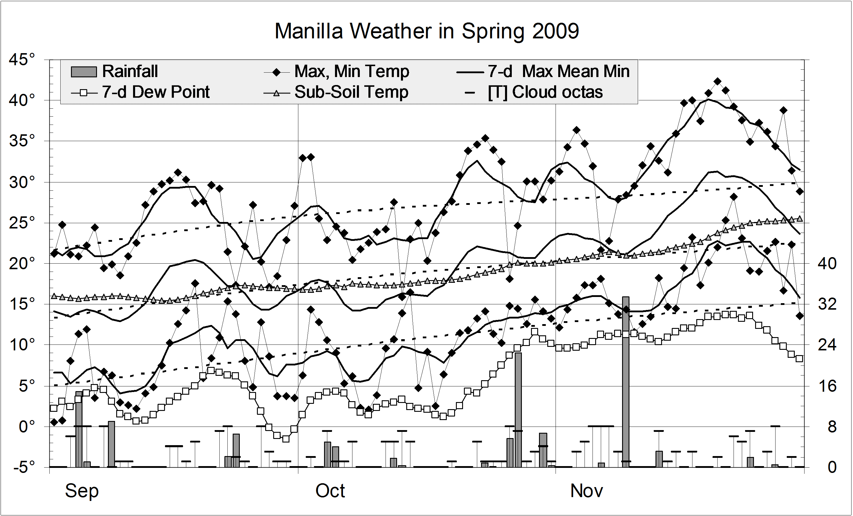
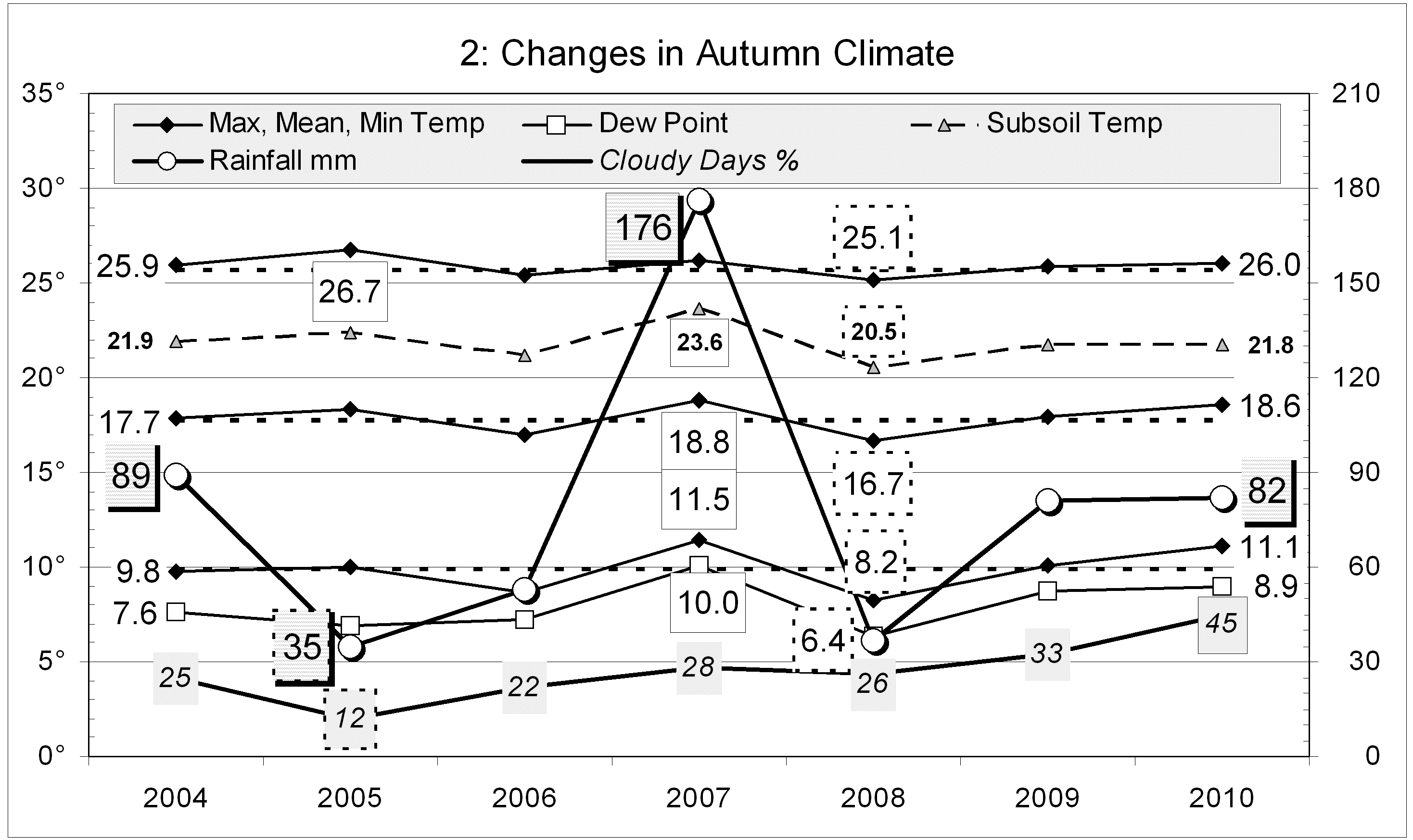
There were dry spells in mid-March, mid-April and early May. Each had very low humidity and mainly sunny weather. The first two had very warm days, but the third had cold nights. The final week brought one third of the season’s rain, with overcast skies, very high humidity, and very warm nights.
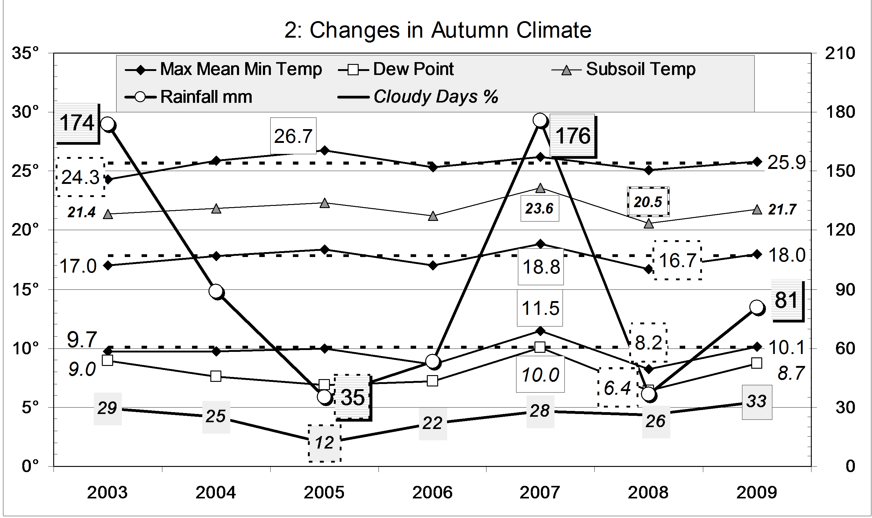
In all, there were 16 rain days, totalling 82.0 mm. No rain day exceeded 10 mm.
The subsoil temperature (750 mm depth) fell as is normal for autumn in Manilla, pausing for a few days after each peak in air temperature. By the end of the season, the subsoil was as warm as the air during the heat of the day.


This year, each of the months March, April and May was the cloudiest in the 11 year record. As a result, this autumn (45%) was also the cloudiest. Of 92 mornings, 41 were cloudy (>4/8 cloud): nearly twice the usual number of 23. The previous highest (last year) had only 30 cloudy mornings.
Due to the cloud, the daily temperature range (14.9°) was a degree narrower than usual. As the mean temperature was rather high, the result was a daily minimum temperature a degree above normal. Other temperatures, and the Dew Point, were near normal.
The total rainfall of 82 mm is again on the 30th percentile for autumn. It is 31 mm below the autumn median rainfall (113 mm).

Climate autumn 2010

Data. Rainfall data is from Manilla Post Office, courtesy of Phil Pinch. Temperatures, including subsoil at 750 mm, and other data are from 3 Monash Street, Manilla.

Warm Nights in Summer 2009-10


Weather log summer 2009-10

No warm spell this summer matched that of late November, which had four days over 40°. There was only one 40° day all summer. By February there were no warm spells.
Summer began hot and very dry, with clear skies and low humidity. Year’s end saw days of rain, low cloud and extremely high humidity. In mid-January the air was again very dry, but cool.


The mean daily maximum temperature was normal, but the mean minimum (18.7°) was the highest in eleven summers. The number of nights warmer than 20° (34) is also the highest, nearly twice the usual number.
The total rainfall of 190 mm is below the long-term summer average of 225 mm. It is in the 42nd percentile.
At 42% cloudy mornings, this summer was very cloudy, but not extremely cloudy like the summer of 2007-08 (53%). These summers shared the record for completely overcast mornings, with 18 each.

Climate for summer 2009-10


Data. Rainfall data is from Manilla Post Office, courtesy of Phil Pinch. Temperatures, including subsoil at 750 mm, and other data are from 3 Monash Street, Manilla.

Spring 2009 warm and dry

Weather log spring 2009

This spring was warm and dry, partly due to the extreme heat wave in the final two weeks. In that period, records were broken for the highest temperature in any month: highest daily maximum (42.6°), highest daily maximum temperature anomaly (+13.5°), highest daily minimum (27.8°), and highest weekly average (31.3°).


Compared to decade averages, the mean maximum (28.4°) was up 2.1° and the mean minimum (11.7°) up 1.3°. For dryness, the morning Dew Point (6.0°) was down 1.5°, and cloudiness (29%) down 1%. Although this spring was very warm and dry, spring 2002 had been much warmer and drier. Values then were: max 29.2°, min 12.1°, Dew Point 5.4° and cloudiness 19%.
In spring 2002 there had been only 66 mm of rain: the fifth lowest on record. Rainfall this spring was 121 mm. Similar spring totals were seen in 2007 (122 mm), 2006 (139 mm), and 2003 (125 mm). These values are on the 30th percentile (which is not very low), but seem low compared to recent extremely wet springs in 2008 (295 mm), 2005 (260 mm) and 1999 (262 mm). The long-term spring median is 156 mm.

Climate spring 2009

Data. Rainfall data is from Manilla Post Office, courtesy of Phil Pinch. Temperatures, including subsoil at 750 mm, and other data are from 3 Monash Street, Manilla.

Winter 2009 was very warm and dry

Weather log winter 2009

Daily maximum temperatures were mainly above normal throughout the season, except in the second week of June and in mid-July. The values of 31.8° and 30.5° on the 23rd and 24th of August were the hottest winter days in this 11-year record. Many such records were set at that time in Central Australia, southern Queensland and northern NSW. Similarly, daily minimum temperatures were mainly above normal, except in early August. The night-time minimum of 18.2° on 25/8/09 was 2° warmer than the warmest previous winter minimum of 30/8/04.
Early morning Dew Points remained a degree or two below the daily minimum temperature through June and July. In August, they remained low while the temperature soared, so that the air became uncomfortably dry.
There were 20 rain days (usually 18). Most rain came early in the season, with the maximum daily reading only 13.2 mm.
Cloudy mornings declined sharply during the season: June had 60%, July 45%, and August only 29%


Of the last eleven winters, this was the warmest. The daily mean temperature, 11.8°, was 1.2° above normal. The daily minimum, 4.5°, was also the warmest, but the daily maximum, 19.1°, did not reach the 19.2° of winter 2002.

This winter was one of the least frosty, with 39 frosts rather than the usual 44. There was only one reading below minus two, while other winters had from three to nineteen! The mean Dew Point of 1.7° was normal for winter.
The rainfall total of 65 mm is well below average for winter (125 mm). It is in the 13th percentile, much wetter than winter 2002 which, at 45 mm, was in the 7th percentile.
This was the second cloudiest winter of the decade. Forty-six percent of the mornings had more than 4/8 cloud. Last winter was a little cloudier, at 48%.

Climate winter 2009

Data. Rainfall data is from Manilla Post Office, courtesy of Phil Pinch. Dew Point values before August 2005 are from Tamworth Airport 6am data supplied by the Bureau of Meteorology. Temperature and other data are from 3 Monash Street, Manilla.

Cloudy Autumn 2009

Weather log autumn 2009

Temperatures cooled as normal in autumn, with few unusual features. Through early March and early May nights were cold, humidities were low, and skies were clear. Later in May, nights were very warm.
There were 16 rain days, which is more than normal (12), but most had very low readings. One rain day in April (36 mm) brought nearly half the season’s rain.


As in the summer, all mean temperatures (daily maximum, mean, and minimum), as well as the morning Dew Point, were normal. Neither of the previous two autumns had been normal: autumn 2008 was very cool and arid; autumn 2007 was very warm and humid.
The total rainfall of 81 mm is on the 30th percentile for autumn. It is 32 mm below the autumn median rainfall (113 mm).
At 33% cloudy mornings, this autumn was the cloudiest of the decade. Autumns average only 25% cloudy mornings, compared to 31% in winter and 30% in spring and in summer.

Climate autumn 2009

Data. Rainfall data is from Manilla Post Office, courtesy of Phil Pinch. Dew Point values before August 2005 are from Tamworth Airport 6am data supplied by the Bureau of Meteorology. Temperature and other data are from 3 Monash Street, Manilla.