3-year trends to July 2018

Hot and Sunny

3-year trends to July 2018

July raw anomaly data (orange)

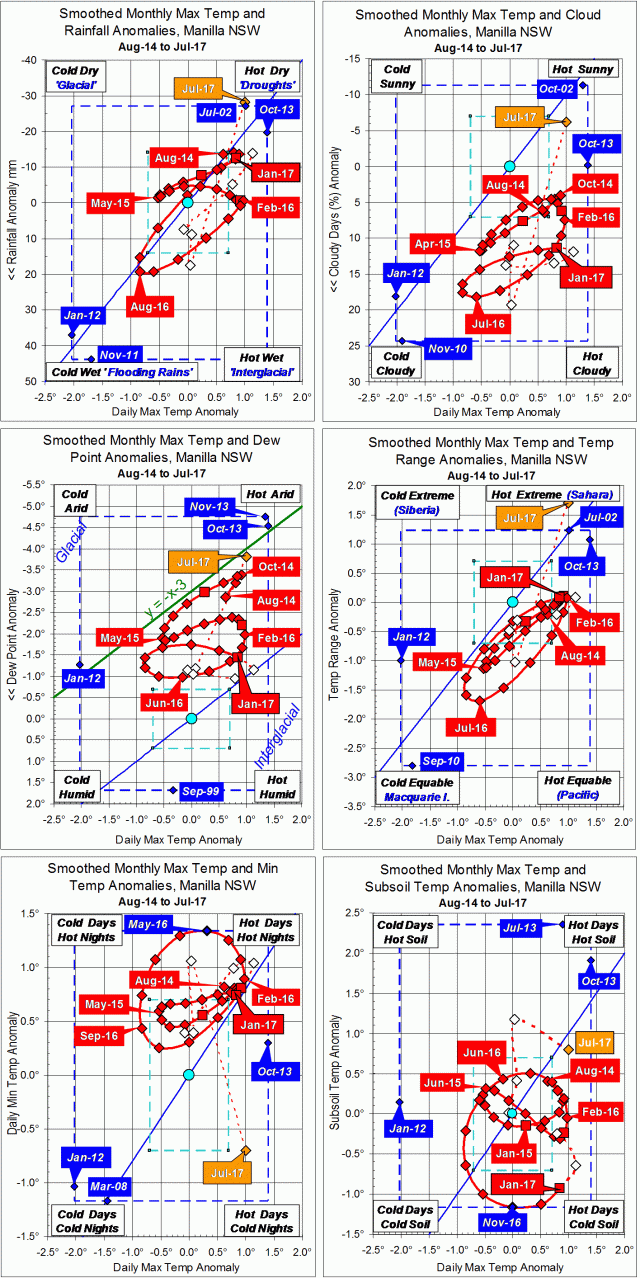
The on-going drought was reflected in moisture anomalies being near the top of the upper four graphs. In the case of cloudiness (top right), persistently cloudy skies became sunny in one single step.
Both daily maximum temperature and subsoil temperature were very high. As daily minimum temperature (lower left) was normal, the extreme daily temperature range (centre right) was due to the high daily maximum temperature (x-axes) alone.

 Fully smoothed data (red)

The last fully-smoothed data is for January 2018. All variables, except subsoil temperature, continued trends set in the spring. While daily maximum temperature and rainfall were already trending up and to the right towards drought, other variables were not at this time.

Daily maximum temperature anomaly reached a record high (smoothed) value of +1.46°.
Rainfall anomaly approached a record low (smoothed, 21st-century) value.
Cloudiness was static near its normal maximum.
Dew point anomaly was low but slowly rising.
Daily temperature range anomaly was high and steady.
Daily minimum temperature anomaly was high and rising.
Subsoil temperature anomaly, which had been falling, began to rise quite rapidly.


Note:

Fully smoothed data – Gaussian smoothing with half-width 6 months – are plotted in red, partly smoothed data uncoloured, and raw data for the last data point in orange. January data points are marked by squares.
Blue diamonds and the dashed blue rectangle show the extreme values in the fully smoothed data record since September 1999.

Normal values are based on averages for the decade from March 1999.* They appear on these graphs as a turquoise (turquoise) circle at the origin (0,0). A range of anomalies called “normal” is shown by a dashed rectangle in aqua (aqua). For values in degrees, the assigned normal range is +/-0.7°; for cloudiness, +/-7%; for monthly rainfall, +/-14 mm.

 * Normal values for rainfall are based on averages for the 125 years beginning 1883.

3-year trends to July 2017

Fine with a wide daily temperature range

3-year climate trends to July 2017

July raw anomaly data (orange)

In July 2017 the largest anomaly was the very wide daily temperature range (middle right graph). This was linked to the daily minimum temperature anomaly (lower left graph) falling suddenly very low.
All moisture indicators pointed to aridity (upwards), and the anomalies of both daily maximum temperature and subsoil temperature were high.

 Fully smoothed data (red)

The latest available fully-smoothed data point, January 2017, showed continued warming in the anomalies of maximum, minimum and subsoil temperatures. These were coming to a peak: the maximum and minimum perhaps in February, but subsoil not for several months.
Moisture anomaly variables were near a peak of aridity. Dew point had peaked (low) in November, cloudiness (low) and daily temperature range (high) in January, with rainfall (low) likely in February.


Note:

Fully smoothed data – Gaussian smoothing with half-width 6 months – are plotted in red, partly smoothed data uncoloured, and raw data for the last data point in orange. January data points are marked by squares.
Blue diamonds and the dashed blue rectangle show the extreme values in the fully smoothed data record since September 1999.

Normal values are based on averages for the decade from March 1999.* They appear on these graphs as a turquoise (turquoise) circle at the origin (0,0). A range of anomalies called “normal” is shown by a dashed rectangle in aqua (aqua). For values in degrees, the assigned normal range is +/-0.7°; for cloudiness, +/-7%; for monthly rainfall, +/-14 mm.

 * Normal values for rainfall are based on averages for the 125 years beginning 1883.

July 2016 had a record warm night

Photo of a pond at sunset

A neighbour’s dam

The second cloudiest month of this century brought the warmest July night.
There were two very warm spells in the trace of weekly average temperature. Both were due mainly to warm nights. The second spell, coming in the third week, reached nearly six degrees above normal. On the morning of Saturday the 23rd, the minimum reading on the screen thermometer, 14.4°, was the highest July minimum in the record from 1999.
Up to the 25th, the weather was changeable, with some days overcast and rainy, and others fine and sunny. A very warm sunny day on the 17th, following a frost, had the unusually wide daily temperature range of 21.9°. From the 25th, the weather settled to what is normal for July. In the whole month, there were sixteen frosts, which is normal.
The highest rainfall reading was only 11.4 mm. Ten days had rainfall recorded, but three of these had 0.2 mm, on days when rain was not seen.

Weather log for July 2016

Comparing July months

The mean daily maximum temperature (16.9°) was normal. The mean daily minimum temperature (4.0°) was two degrees above normal, making the average temperature (10.5°) one degree above normal. Similarly, the subsoil temperature (14.7°) was one degree above normal.
The daily temperature range, normally 15.0°, was 12.9°, not quite as narrow as in 2010 (12.3°). The early morning dew point was normal. At 2.2°, it was so close the the daily minimum temperature (4.0°) that fogs were to be expected.
The month was extraordinarily cloudy. Cloud cover is assessed by the number of octas (eighths) of the sky seen to be covered by cloud at 9 am. I compare cloudiness of months by the percentage of “cloudy mornings”: those when I see more than four octas of cloud. This month, with 21 cloudy mornings, had 68%. July normally has only 35%. The only month in this century with a higher value was June 2013, with 73%.
The monthly rainfall total of 32.4 mm is below the average (41 mm), in the 47th percentile. The greatest rainfall “shortage” is now in the 48-month total (2221 mm) which is in the 14th percentile. Both Greenhatch Creek and Rushes Creek are just flowing.

Climate for July 2016.


Data. Rainfall figures for this month are from the automatic rain gauge at Manilla, published on the internet by the Bureau of Meteorology as Station 55031. All other data, including subsoil at 750 mm, are from 3 Monash Street, Manilla.

3-year trends to July 2016

Parametric plots of smoothed climate variables at Manilla
“July 2016 extreme cloudiness”

Trends to July 2016.

July raw anomaly data (orange)

In July 2016, raw anomalies for most variables returned towards normal from extreme values in June. Some now fell within the normal range: daily maximum temperature, rainfall, and dew point. Subsoil temperature remained high. Daily temperature range was still very low and daily minimum temperature very high. The variable that became even more extreme in this month was cloudiness.

 Fully smoothed data (red)

Fully-smoothed data can now be calculated up to January 2016. By that month the climate, as smoothed, was slightly warmer than in my 1999 to 2009 reference decade.


Note:

Fully smoothed data – Gaussian smoothing with half-width 6 months – are plotted in red, partly smoothed data uncoloured, and raw data for the last data point in orange. January data points are marked by squares.
Blue diamonds and the dashed blue rectangle show the extreme values in the fully smoothed data record since September 1999.

Normal values are based on averages for the decade from March 1999.* They appear on these graphs as a turquoise (turquoise) circle at the origin (0,0). A range of anomalies called “normal” is shown by a dashed rectangle in aqua (aqua). For values in degrees, the assigned normal range is +/-0.7°; for cloudiness, +/-7%; for monthly rainfall, +/-14 mm.

 * Normal values for rainfall are based on averages for the 125 years beginning 1883.

Record warm nights

Two very warm nights

On two mornings this month, the 21st and 23rd, the minimum temperature in my thermometer screen was higher than it has ever been in July. That is, in the 17-year record that I began in March 1999.
These minimum readings were 14.3° and 14.4°. The highest July minimum had been 13.5° (31/07/2010), and only five readings had ever been above 12°. Such readings are more than ten degrees higher than normal in July.
In fact, one of the nights was much warmer than the minimum temperature indicates.

Minima not always at night

High minimum temperature readings are the usual evidence of warm nights. Unfortunately, they are not the same thing. Especially in the case of very high readings, they can be misleading.
The catch is that we expect daily maximum temperature to occur in daytime, when the sun is in the sky, and daily minimum temperature to occur at night, when it is not. In Manilla’s very sunny climate, the maximum is usually about fifteen degrees higher than the minimum. We can expect the maximum about 3 pm, and the minimum about 6 am.
When a thermometer is read at 9 am (as they are), the maximum reading recorded on it is usually that of the afternoon, and the minimum reading that of just before sunrise. Usually, but not always!
Times when nights are very warm are usually cloudy. The clouds form a blanket that keeps us warm. Because they also block the sun in daytime, the daily maximum temperature may be almost the same as the daily minimum. The times when maxima and minima occur may become vague. As a complication, warm nights tend to happen when warm air comes to us on the wind. Then much colder air often follows. If the cold air arrives before 9 am, it will lower the minimum temperature reading, destroying the evidence of a warm night.

Thermograph Traces

I do not have a thermograph that makes a continuous temperature trace. The trace for Tamworth Airport can be seen here. (Choose a date.)

For this month’s warmest night, the Tamworth thermograph trace shows that the daily minimum temperature value is misleading due to these factors. The night was much warmer.
Between 5:30 pm on the 22nd and 5:30 am on the 23rd, the lowest temperature, which came at 7:40 pm, was 17.8°. Most of the night, from midnight to 4:00 am, was above 20°! Yet the (Tamworth) minimum for the 24 hour period was 12.5°.
Earlier in the month, in the 24 hours to 9 am on the 6th, the conventional maximum and minimum values were highly misleading. The daily maximum was the very last reading (10.0°) and the daily minimum the very first, 24 hours earlier (6.5°). The afternoon maximum temperature was 8.0° and the pre-dawn minimum temperature was 8.2°. On that date, the day was 0.2° cooler than the night!