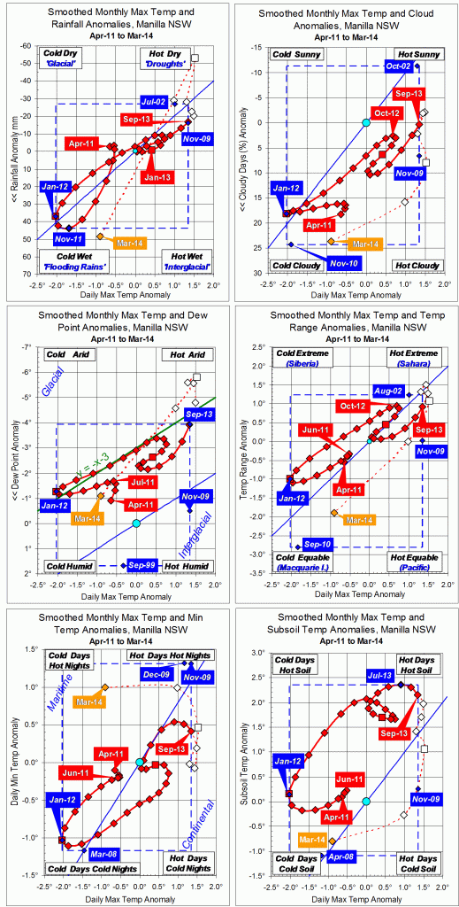
3-year trends to May 2014

Parametric plots of smoothed climate variables at Manilla
“Drought status not clear”

Trends to May 2014

May data (orange)

Raw data for May 2014 give mixed signals on whether the drought is fading. Daily maximum temperature is now on the high limit of the normal range and rainfall again well into the “drought” range. However, other variables do not agree: skies were very cloudy, and dew point and daily temperature range were back to normal.

Fully smoothed data (red)

The spring months (SON) of 2013 are now fully smoothed, with some variables showing a drought peak in that season.
Smoothed daily maximum temperature anomaly peaked in October, reaching a record high of +1.39°, beating +1.34° in November 2009 and +1.30° in September-October 2002. Through spring the smoothed rainfall anomaly decreased; it may have reached a minimum in January. Dew point also decreased, the smoothed anomaly reaching a new record low of -4.85° in November, and likely to reach a minimum in December.
Cloudiness reached a minimum in October, and daily minimum temperature and subsoil temperature anomalies had reached maximum values earlier, in July.

Note:
Fully smoothed data – Gaussian smoothing with half-width 6 months – are plotted in red, partly smoothed data uncoloured, and raw data for the last data point in orange. January data points are marked by squares.
Blue diamonds and the dashed blue rectangle show the extreme values in the fully smoothed data record since September 1999.

Normal values are based on averages for the decade from March 1999. They appear on these graphs as a turquoise (turquoise) circle at the origin (0,0). A range of anomalies called “normal” is shown by a dashed rectangle in aqua (aqua). For values in degrees, the assigned normal range is +/-0.7°; for cloudiness, +/-7%; for monthly rainfall, +/-14 mm.


3-year trends to April 2014

Parametric plots of smoothed climate variables at Manilla
“Are we coming out of drought?”

Trends to April 2014

After a very cool moist March, raw values of climate anomalies for April 2014 are nearly all back near the (slightly smoothed) values for February. However, neither month was as hot or dry as December or January.
Fully-smoothed values for October 2013 show the deepening drought. That month set a new 21st century record for smoothed daily maximum temperature anomaly of +1.39°, beating the value of +1.35° set in November 2009. It also set a new low record for dew point anomaly of -4.53°, far more arid than the record set the previous month: -3.53°.
These curves show clearly that the climate (at this site) consistently became warmer and drier through the two years from spring 2011 to spring 2013, except for a brief time of reversal in the six warm-season months from October 2012 to March 2013.

Note:
Fully smoothed data – Gaussian smoothing with half-width 6 months – are plotted in red, partly smoothed data uncoloured, and raw data for the last data point in orange. January data points are marked by squares.
Blue diamonds and the dashed blue rectangle show the extreme values in the fully smoothed data record since September 1999.

3-year trends to March 2014

Parametric plots of smoothed climate variables at Manilla

“Plunge toward ‘flooding rains’ *Trends to March 2014.

Raw values of climate anomalies for March 2014 are nearly all in the bottom left corner “flooding rains” after months in the opposite corner “droughts”. Daily minimum temperature remains high: nights are warm.
Fully-smoothed values for September 2013 show that the drought was becoming as severe as in 2002. The dew point anomaly reached a new record low value of -3.94°.


* By arrangement with the Licensor, The Dorothea Mackellar Estate, c/- Curtis Brown (Aust) Pty Ltd.


Note: Fully smoothed data – Gaussian smoothing with half-width 6 months – are plotted in red, partly smoothed data uncoloured, and raw data for the last data point in orange. January data points are marked by squares. Blue diamonds and the dashed blue rectangle show the extreme values in the fully smoothed data record since September 1999.

2013-14: Third Driest Summer

Weather log summer 2013-14.

After a cool start, this summer had no more cool weather. There were five warm spells 3° to 4° warmer than normal. Days were particularly warm, with a new 21st century record high of 43.7° set on 3/1/14. During warm spells, nights were also warm, but often 17° cooler than the days. The air was phenomenally dry in early January, with morning dew points (usually 14°) falling below zero three times. There were only 14 rain days (usually 21), and the heaviest fall of 18.8 mm was a 21st century record low for summer.


Taking average values, this summer had the highest daily maximum temperature this century: the value of 34.3° beats the 34.1° of 2005-6. However, the daily mean of 26.1° does not beat the 26.3° of 2005-6. By contrast, the summer of 2011-12 was the coldest, by day and by night. The total rainfall of just 84.8 mm makes this the third driest summer in the 131-year record, after 1929-30 (66 mm) and 1964-5 (70 mm). The summers of 1999-2000 and the two following were also very dry (125 mm, 158 mm, 137 mm) but this summer had not only less rain but also very much drier air and a wider daily range of temperature. Both the low dew point, 8.6° , and the wide daily temperature range, 16.4°, were record values. The earlier dry summers were less cloudy, however.Climate summer 2013-14.

Data. Rainfall data is from Manilla Post Office, courtesy of Phil Pinch. Temperatures, including subsoil at 750 mm, and other data are from 3 Monash Street, Manilla.

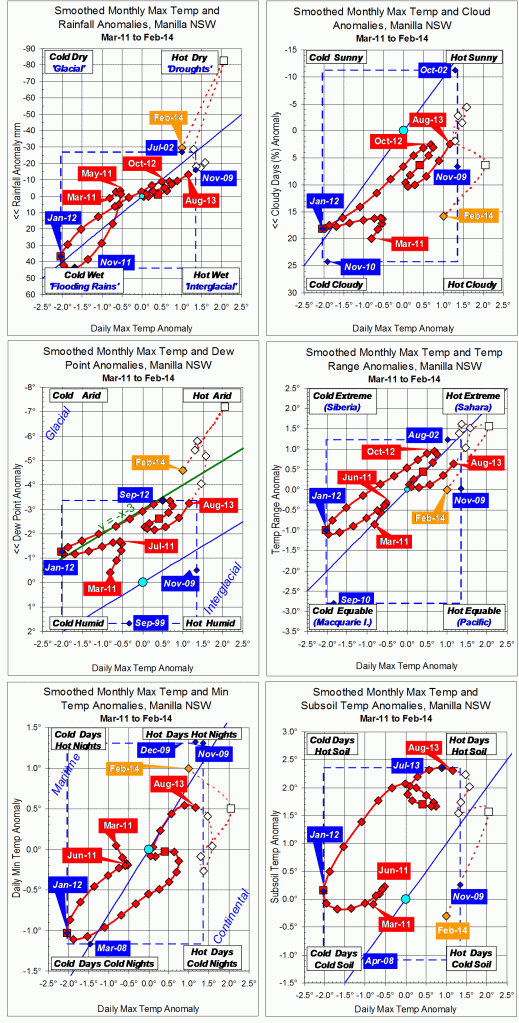
3-year trends to February 2014

Parametric plots of smoothed climate variables at Manilla

“Drought advanced in winter; now retreating”Trends to February 2014

Raw values of climate anomalies for February 2014 moved positively away from the high temperature and low moisture of “droughts”. Daily minimum temperature increased but this, too, goes with more moisture.
Data points for the three months of winter 2013 are now fully-smoothed. They show a steady progress towards drought in increasing maximum temperature and daily temperature range, and reducing rainfall, cloudiness, and humidity (dew point). Daily minimum temperature and subsoil temperature  peaked already in July.

Note: Fully smoothed data – Gaussian smoothing with half-width 6 months – are plotted in red, partly smoothed data uncoloured, and raw data for the last data point in orange. January data points are marked by squares. Blue diamonds and the dashed blue rectangle show the extreme values in the fully smoothed data record since September 1999.