Spring 2010 cloudy, damp and cool

Weather log spring 2010

Days this spring were very cool, keeping the seven-day mean maximum curve below normal nearly all the time. Twenty-two mornings were overcast, twice the usual number, and the number of rain days (29) was the highest in twelve springs.


The mean daily maximum temperature (24.1°) was a record low in this data set, more than 4° lower than last year. Similarly, the daily temperature range (12.9°) was unusually narrow, 3.5° narrower than last year. Other temperatures were near normal, except for the record low Subsoil temperature of 17.5°. Cloudy mornings, at 56%, were a record high.
The total spring rainfall of 249 mm is in the 86th percentile. While this is well above the long-term spring average of 166 mm, four of the previous eleven springs were even wetter: 1999, 2000, 2005, and 2008.
Climate spring 2010

Data. Rainfall data is from Manilla Post Office, courtesy of Phil Pinch. Temperatures, including subsoil at 750 mm, and other data are from 3 Monash Street, Manilla.

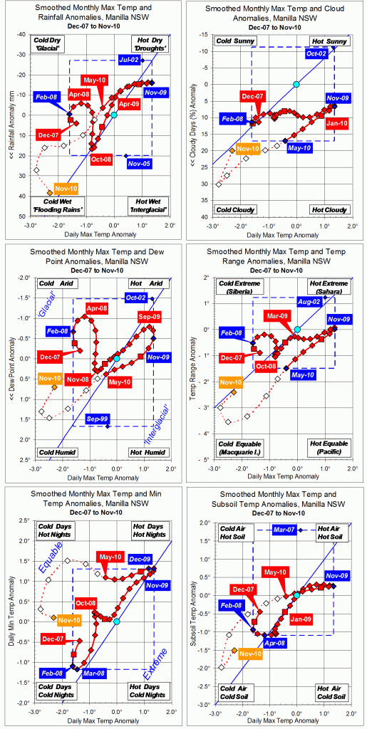
3-year trends to November 2010

Parametric plots of smoothed climate variables at Manilla
“Near a “flooding rains” peak?”

Trends to November 2010

Data points for climate anomalies in the autumn months (MAM) of 2010 are now fully smoothed.

  • In autumn 2010 the smoothed maximum temperature anomaly fell much faster than it had risen in the previous autumn (clearer on the second and fourth graphs). Partially smoothed later values suggest that an extreme negative temperature anomaly came in October 2010.
  • Rainfall anomalies are plotted (inverted) on the y-axis of the first graph. Fully-smoothed autumn values rose with falling maximum temperature, but remained negative. Later values generally rose rapidly to an extreme positive raw value of +38 mm in November.
  • During autumn of 2010 the anomaly of percent cloudy days rose to a new record for fully-smoothed values. It continued to rise to an apparent extreme in October 2010.
  • Early morning dew point was positive and rising in autumn. It seems to have peaked at less than a record value in September 2010.
  • The anomaly of daily temperature range fell during autumn to a new negative record for smoothed data. It continued to fall to an apparent negative peak in September 2010.
  • In autumn daily minimum anomalies fell little below the peak of December 2009. Later they traced an arc through the “Equable” zone of the graph, ending near zero.
  • The autumn subsoil temperature anomaly was near zero and scarcely falling. It then accelerated downwards to an apparent extreme in October 2010.

Note:
Fully smoothed data – Gaussian smoothing with half-width 6 months – are plotted in red, partly smoothed data uncoloured, and raw data for the last data point in orange. January data points are marked by squares.
Blue diamonds and the dashed blue rectangle show the extreme values in the fully smoothed data record since September 1999.

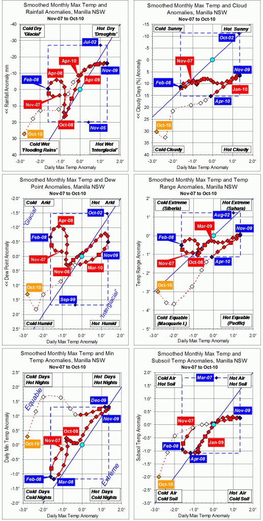
3-year trends to October 2010

Parametric plots of smoothed climate variables at Manilla
“More Flooding Rains”

Trends to October 2010

The October 2010 data, marked with orange diamonds, are again in the “Flooding Rains” area in the bottom left corner of five of the six graphs. Anomaly values of rainfall, cloudy days, Dew Point, temperature range and subsoil temperature are extreme. The Minimum temperature anomaly is now near zero but falling rapidly.

Note:
Fully smoothed data – Gaussian smoothing with half-width 6 months – are plotted in red, partly smoothed data uncoloured, and raw data for the last data point in orange. January data points are marked by squares.
Blue diamonds and the dashed blue rectangle show the extreme values in the fully smoothed data record since September 1999.

3-year trends to September 2010

Parametric plots of smoothed climate variables at Manilla
“Flooding Rains”

Trends to September 2010

The September 2010 data, marked with orange diamonds, are in the “Flooding Rains” area in the bottom left corner of five of the six graphs. Anomaly values of rainfall, cloudy days, Dew Point, temperature range and subsoil temperature are extreme. The Minimum temperature anomaly has remained very high for a year.

Note:
Fully smoothed data – Gaussian smoothing with half-width 6 months – are plotted in red, partly smoothed data uncoloured, and raw data for the last data point in orange. January data points are marked by squares.
Blue diamonds and the dashed blue rectangle show the extreme values in the fully smoothed data record since September 1999.

Winter 2010 wet, with few frosts

 An episode of maritime climate

I have posted this seasonal report for winter 2010 on the front page, as a sticky post, to show how the climate of that season was not normal. It was not the average temperature or the rainfall that were unusual. The sky was very cloudy, the humidity very high, and the daily temperature range very low. The climate was equable, as one would expect at a place near the sea: a maritime climate. More in the footnote*

Weather log winter 2010

Temperatures this winter changed little from month to month. June, July and August each had temperatures near the season averages: maximum 17.0°, mean 10.7° and minimum 4.5°. Warm days were rare: only 11 exceeded 20° (usually 25). This winter was even less frosty than the last, with only 32 frosts (usually 44). The lowest minimum was -3.1°.
There were 33 rain days, about twice the usual number.


In terms of daily mean temperature, this winter was normal, However, cool days and warm nights made the daily temperature range (12.5°) narrower than in any winter in the 12-year record. It was also the cloudiest, at 49% cloudy mornings. Manilla’s climate became much more cloudy three years ago, when the average number of cloudy mornings in a month jumped suddenly from nine to twelve (See also these other graphs.). Humidity, as shown by early morning Dew Point was also very high this winter. All these changes reflect a more maritime climate, as on the coast.
Each month would have had rainfall close to average, were it not for one reading of 34.2 mm at the end of July. The total of 160 mm is in the 70th percentile, like that of the wet winters of 2005 and 2007.

Climate winter 2010

*Footnote. The nature of this episode is clear on the 3-year graphs of climate trends, such as that for August 2011. The top left graph shows that, in June, July, and August 2010, rainfall was a little high and daily maximum temperature rather low. The bottom left graph shows the main anomaly: daily minimum temperature remained extremely high while daily maximum rapidly fell, reaching a record low value by October 2010. From July to November that year the difference between daily maximum and daily minimum temperature was some three degrees less than normal.
The middle graph on the right shows directly that the daily temperature range in those months was at record low (narrow) values.

Data. Rainfall data is from Manilla Post Office, courtesy of Phil Pinch. Temperatures, including subsoil at 750 mm, and other data are from 3 Monash Street, Manilla.