Winter 2018 had the driest air

A gum-tree blowing in the wind

Wind-blown Gum-tree

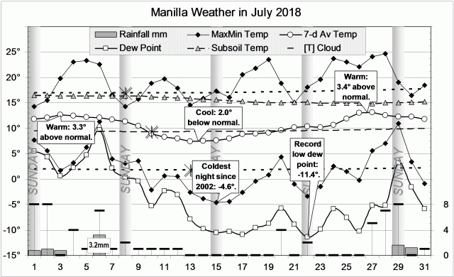
Temperatures varied widely, especially at night. In both mid-July and mid-August, the weekly mean night temperatures were more than 4° low. At these times, the air was extremely dry.
Early in July night temperatures were nearly 4° high, while late in July it was the day temperatures that were more than 4° high. The daily temperature range was almost 21° in mid-July, having been less than 13° in mid-June.
There were 16 rain days, but the highest reading (estimated) was only 10.2 mm.

Weather log for winter 2018

Last winter’s report had been headlined: “Dry air in winter 2017”. This winter was even drier by all measures. In particular, the mean early morning dew point set a new record of -3.0°. The best match in this century is the winter of 2002. Both had warm days, cold nights, wide daily temperature range, little cloud and low dew point.
The total rainfall of 42 mm makes this the 9th driest winter on record, displacing winter 2002, which had 44 mm. (The year 1888 had the lowest winter rainfall total: 6 mm. However, daily readings are missing. The next lowest was 1946, with 29 mm, then 1972 and 1982, both with 32 mm.)

Climate for winter 2018


Data. A Bureau of Meteorology automatic rain gauge operates in the museum yard. From 17 March 2017, 9 am daily readings are published as Manilla Museum, Station 55312.  These reports use that rainfall data when it is available. During this winter season 20 daily readings were missed, including several days with significant falls of rain. I have used my own readings for the whole season.

All other data, including subsoil at 750 mm, are from 3 Monash Street, Manilla.

Driest Air in August 2018

Tree with a face painted on it.

Painted Box Tree

Temperatures were not far from normal during the month, except that the weekly mean was 3.2° low about the 20th. There were 20 frosts (normally 15), but the coldest morning fell only to -2.7°.
Some rain fell early in the month. Later, with the cold nights, the air became extremely dry, reaching a new record early morning dew point of -12.1°. Abruptly, the 25th brought overcast and high humidity, then rain and fog. Estimated rain was 9.0 mm on the 26th, 10.2 mm on the 27th, and 0.8 mm on the 28th.

Weather log August 2018.

Comparing August months

The month was rather cool, with a mean (10.7°) that was 0.4° below normal, and cold nights (2.0°), 1.1° below normal. Measures of moisture were only slightly low, except that humidity was extremely low, setting a new record mean early morning dew point of -4.2°.
Moderate falls of rain totalled 28.2 mm (estimated), which is at the 40th percentile for August.
I have reported the shortage of rainfall separately ( “Drought Sixth Month: August 2018”) .

Climate in August months.


Data. A Bureau of Meteorology automatic rain gauge operates in the museum yard. From 17 March 2017, 9 am daily readings are published as Manilla Museum, Station 55312.  These reports use that rainfall data when it is available.  The record was again defective in August 2018. Seven daily readings were missing. On one of the missing days (the 27th) my rain gauge showed 10.2 mm, the highest daily reading for the month. I have substituted my non-standard gauge readings for all days of both July and August.

All other data, including subsoil at 750 mm, are from 3 Monash Street, Manilla.

3-year trends to August 2018

Cooler and Moister

3-year trends to August 2018

August raw anomaly data (orange)

For now, a retreat from drought is shown by lower temperature, particularly at night, and more rain. Dew point remains very low.

 Fully smoothed data (red)

The summer season, ending in February 2018, can now be fully smoothed. February has a new 21st century record [in blue] for smoothed daily maximum temperature anomaly of +1.58° [x-axis all graphs]. This is bound to be broken by smoothed values for March, and perhaps for April. The record for negative rainfall anomaly (set in the drought of July 2002) is also likely to be broken in March.

Through the summer, all three temperatures rose, and rainfall fell. Other variables were static.


Note:

Fully smoothed data – Gaussian smoothing with half-width 6 months – are plotted in red, partly smoothed data uncoloured, and raw data for the last data point in orange. January data points are marked by squares.
Blue diamonds and the dashed blue rectangle show the extreme values in the fully smoothed data record since September 1999.

Normal values are based on averages for the decade from March 1999.* They appear on these graphs as a turquoise (turquoise) circle at the origin (0,0). A range of anomalies called “normal” is shown by a dashed rectangle in aqua (aqua). For values in degrees, the assigned normal range is +/-0.7°; for cloudiness, +/-7%; for monthly rainfall, +/-14 mm.

 * Normal values for rainfall are based on averages for the 125 years beginning 1883.

July 2018 had deep frosts

A young kurrajong tree

Kurrajong in Drought

There were warm spells at each end of the month. Between them, fine cool weather was marked by black frosts with temperatures down to -4.6°. That is colder than had been seen in the sixteen years since 2002. With the freezing nights came extremely low early-morning dew points that beat the previous record value of -10.0°. The new dew point record set on the 22nd was -11.4°.
Six days had light rain. The wettest, on the 6th, registered only 3.2 mm (estimated).

Weather log July 2018

Comparing July months

Despite two nights being below -4°, the number of frosts (17) was normal, as was the mean daily minimum temperature (1.8°). Days, however, set a record mean maximum of 19.2°, making the daily temperature range (17.4°) very high. Other variables were also typical of drought: both cloudy skies (only 19%), and the early morning dew point (-4.0°) were record low values for July. This month was very like July in the drought year of 2002.

The rainfall total of 8.6 mm (estimated) was at the 12th percentile. Persistent low monthly rainfall values have carried the 3-, 4-, and 5-month totals down well below the 1st percentile that marks extreme rainfall shortage. Other totals now classed as “severe shortages” include the six-year total.

Climate in July months

Developing Drought

The rainfall shortages that have now become extreme are covered in other posts, such as “Drought Fifth Month: July 2018”.


Data. A Bureau of Meteorology automatic rain gauge operates in the museum yard. From 17 March 2017, 9 am daily readings are published as Manilla Museum, Station 55312.  These reports use that rainfall data when it is available.  The record was defective for July. Ten daily readings were missing. In addition, 1.0 mm was registered on the 20th when no rain or dew was seen. I have substituted my non-standard gauge readings for all days of July.

All other data, including subsoil at 750 mm, are from 3 Monash Street, Manilla.

3-year trends to July 2018

Hot and Sunny

3-year trends to July 2018

July raw anomaly data (orange)

The on-going drought was reflected in moisture anomalies being near the top of the upper four graphs. In the case of cloudiness (top right), persistently cloudy skies became sunny in one single step.
Both daily maximum temperature and subsoil temperature were very high. As daily minimum temperature (lower left) was normal, the extreme daily temperature range (centre right) was due to the high daily maximum temperature (x-axes) alone.

 Fully smoothed data (red)

The last fully-smoothed data is for January 2018. All variables, except subsoil temperature, continued trends set in the spring. While daily maximum temperature and rainfall were already trending up and to the right towards drought, other variables were not at this time.

Daily maximum temperature anomaly reached a record high (smoothed) value of +1.46°.
Rainfall anomaly approached a record low (smoothed, 21st-century) value.
Cloudiness was static near its normal maximum.
Dew point anomaly was low but slowly rising.
Daily temperature range anomaly was high and steady.
Daily minimum temperature anomaly was high and rising.
Subsoil temperature anomaly, which had been falling, began to rise quite rapidly.


Note:

Fully smoothed data – Gaussian smoothing with half-width 6 months – are plotted in red, partly smoothed data uncoloured, and raw data for the last data point in orange. January data points are marked by squares.
Blue diamonds and the dashed blue rectangle show the extreme values in the fully smoothed data record since September 1999.

Normal values are based on averages for the decade from March 1999.* They appear on these graphs as a turquoise (turquoise) circle at the origin (0,0). A range of anomalies called “normal” is shown by a dashed rectangle in aqua (aqua). For values in degrees, the assigned normal range is +/-0.7°; for cloudiness, +/-7%; for monthly rainfall, +/-14 mm.

 * Normal values for rainfall are based on averages for the 125 years beginning 1883.