Keepit Dam boom, May 2019
The month began warm, with the night of the 2nd being, at 18.0°, the warmest May night of the new century. There was a second warm spell nearly four degrees above normal about the 20th.
The first frost (by my reading) came on the 12th of May this year, and on the 15th of May last year. The middle date of first frost is May 13th.
There were three rain days (usually four) but nearly all the rain (61 mm) was recorded on the 4th.

Comparing May months
The mean temperature this month (14.6°) was high, but not as high as in May 2007 (15.1°). However, the mean daily minimum temperature (8.1°) was the warmest for May in the new century: above normal by 2.3°.
A rather narrow daily temperature range (13.1°) and high percentage of cloudy days (45%) showed moisture above normal.
The (estimated) rainfall total of 61.8 mm was very high, in the 75th percentile. Because no rain at all had fallen in April, the total for the two months together reached only to the 26th percentile.

Drought
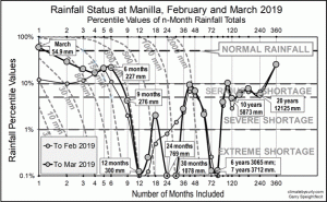
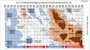
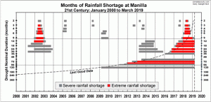
The on-going unprecedented drought is reported in another post.
Data. A Bureau of Meteorology automatic rain gauge operates in the museum yard. From 17 March 2017, 9 am daily readings are published as Manilla Museum, Station 55312. These reports use that rainfall data when it is available. Since no 9 am readings have been recorded since August 2018, I have substituted my non-standard gauge readings for all days.
All other data, including subsoil at 750 mm, are from 3 Monash Street, Manilla.