Cloudy Autumn 2009

Weather log autumn 2009

Temperatures cooled as normal in autumn, with few unusual features. Through early March and early May nights were cold, humidities were low, and skies were clear. Later in May, nights were very warm.
There were 16 rain days, which is more than normal (12), but most had very low readings. One rain day in April (36 mm) brought nearly half the season’s rain.


As in the summer, all mean temperatures (daily maximum, mean, and minimum), as well as the morning Dew Point, were normal. Neither of the previous two autumns had been normal: autumn 2008 was very cool and arid; autumn 2007 was very warm and humid.
The total rainfall of 81 mm is on the 30th percentile for autumn. It is 32 mm below the autumn median rainfall (113 mm).
At 33% cloudy mornings, this autumn was the cloudiest of the decade. Autumns average only 25% cloudy mornings, compared to 31% in winter and 30% in spring and in summer.

Climate autumn 2009

Data. Rainfall data is from Manilla Post Office, courtesy of Phil Pinch. Dew Point values before August 2005 are from Tamworth Airport 6am data supplied by the Bureau of Meteorology. Temperature and other data are from 3 Monash Street, Manilla.

Normal Climate in Summer 2008-09


Weather log summer 2008-09

For most of the summer, 7-day average temperatures got steadily warmer. From 4° below normal in mid-December they rose to 4° above normal in early February. They then crashed to 5° below normal before recovering. Two days exceeded 40°: February 6th (40.1°) and February 9th (40.9°). In ten summers, 19 days have exceeded 40°, the hottest being 42.0° on 21/2/04.
This season had the coldest summer day so far this century: February 14th 2009, with 17.8°. That is 15.3° below normal (it would be normal in winter, not summer)!

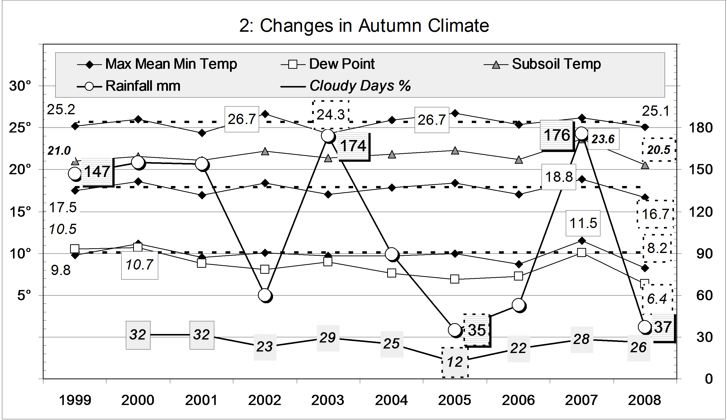
NOTE. This is the daily maximum reading that is furthest below normal in the ten-year record from March 1999. There have been only 23 days when the maximum was more than 10° below normal. Only 18 days were more than 8° above normal. The furthest above normal (by 10.5°) was the reading of 38.8° on November 10th 2002.

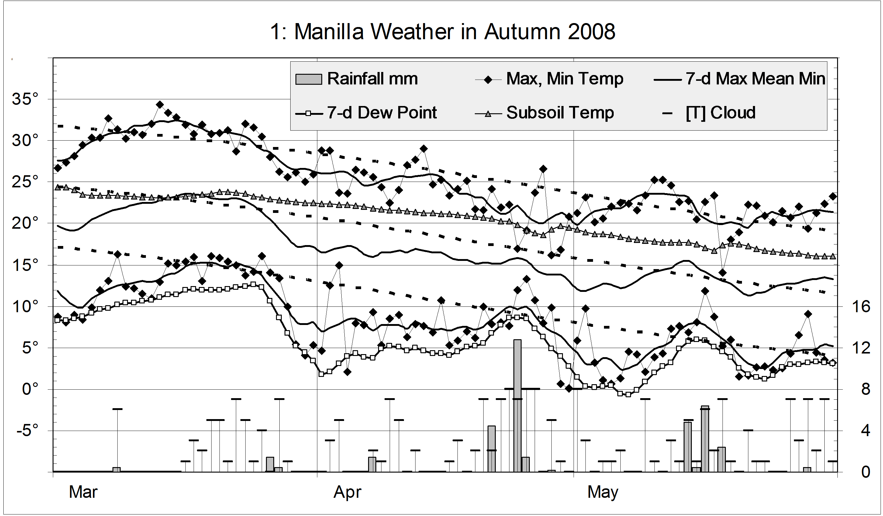
Humidity was low both in the early cool spell and in the later hot spell. At both times the daily range of temperature was high (17°) and the skies mainly clear.
There were 23 rain days, which is normal and far fewer than the 33 rain days last summer. Dry spells (with falls less than 1 mm) were long: 21 days from the 30th of December, and 16 days from the 25th of January. February the 15th was the wettest day, with 51.2 mm, and the summer total was 228 mm.
The number of overcast mornings (12) was normal for summer, but the number of cloud-free mornings (17) was very low, as it was last summer (13).


All mean temperatures (daily maximum, mean, and minimum) were normal this summer. They were much higher than last summer, with the daily maximum a remarkable 2.8° higher. The mean morning Dew Point was also normal.

The total rainfall of 228 mm is very close to the long-term summer average of 227 mm. It is on the 54th percentile.
At 38% cloudy mornings, this summer was cloudy, but not extremely cloudy like last summer (53%).
The summers of 05-06 and 07-08 were both very wet (319 mm and 311 mm). They differed in other ways: summer 05-06 was hot, humid and not cloudy; summer 07-08 was cold, not humid, and extremely cloudy.

Climate for summer 2008-09


Data. Rainfall data is from Manilla Post Office, courtesy of Phil Pinch. Dew Point values before August 2005 are from Tamworth Airport 6am data supplied by the Bureau of Meteorology. Temperature and other data are from 3 Monash Street, Manilla.

Spring 2008 was the seventh wettest

Weather log spring 2008

There were about six cycles of low and high temperature during spring. The third week of October was particularly cool, with dry air. By contrast, days and nights were more than seven degrees warmer by the end of the month.
There were 27 rain days, eight more than usual. Although the total rainfall (295 mm) was extremely high, the highest daily fall was only 52 mm. There were only two mild frosts early in the season.


The mean temperature was normal for spring. Rather cool days and rather warm nights combined to make the daily temperature range (14.4°) the narrowest for the decade, well below the average of 15.9°.(Note added. The mean daily temperature range for spring 2010 was far narrower: 12.9°.)
This spring was rather more humid, and had rather more cloud than usual.
This was the seventh wettest spring in the 126-year record, equal with 1973. Wetter springs occurred only in two clusters. The first cluster was 1916 (326 mm) and 1917 (327 mm); the second was 1949 (330 mm), 1950 (379 mm), 1954 (319 mm) and 1955 (321 mm). (Note added. Spring 2011 was very much wetter, with a record spring rainfall of 431.7 mm.)

Climate spring 2008

Data. Rainfall data is from Manilla Post Office, courtesy of Phil Pinch. Dew Point values before August 2005 are from Tamworth Airport 6 am data supplied by the Bureau of Meteorology. Temperatures, including subsoil at 750 mm, and other data are from 3 Monash Street, Manilla.

Winter came very late in 2008*

Weather log winter 2008

The daily weather log

For most of June and July, temperatures were warmer than normal, especially at night. There were a couple of severe frosts in late June, and one in mid-July. The coldest part of winter, however, came extremely late. In the second week of August, both days and nights were six degrees colder than normal. There were more sub-zero nights in August than in June and July together.
Early morning dew points above 7° in early June showed high humidity. Later, dew points below zero showed the air was extremely dry in late June and almost all of August.
The winter was a little less frosty than usual, with 40 frosts rather than the usual 44. There were 24 readings below zero and 7 below minus two, but none below minus four.
There were 21 rain days, totaling 136 mm. Most rain came early in the season. The first rain day, with 38.2 mm, was the wettest winter day in ten years.
July and August were extremely cloudy months, with 52% and 55% cloudy mornings. June, at 37%, was also cloudy.

Comparing winter seasons

Mean daily temperatures (daily maximum, minimum, and mean) were close to normal this winter. Because the maximum was slightly down, and the minimum slightly up, the daily temperature range was reduced. At 14.1°, it was narrower than the normal 15.3° but not extreme like the 13.2° of last winter.
The mean dew point of 1.9° was normal for winter.
The rainfall total of 134 mm is above the long-term average for winter (125 mm). The graph includes the ninth driest winter, 2002. Just ten years ago, 304 mm of rain in the winter of 1998 made it the second wettest on record.
This was the cloudiest winter of the decade. Forty-eight percent of the mornings had more than 4/8 cloud. The winter average is thirty-one percent. The graph suggests a trend to more cloudy winters since 2002.

Climate winter 2008

Data. Rainfall data is from Manilla Post Office, courtesy of Phil Pinch. Dew Point values before August 2005 are from Tamworth Airport 6 am data supplied by the Bureau of Meteorology. Temperatures, including subsoil at 750 mm, and other data are from 3 Monash Street, Manilla.

* The title is a rhyming anapestic tetrameter. With the original “by”-line, it was a rhyming  anapestic hexameter. No-one noticed.

Autumn 2008 was dry and cool

Weather log autumn 2008

The daily weather log

Temperatures were about normal in mid-March and again during parts of May. Otherwise they were low. The daily temperature range was generally higher than usual, but was less on rainy days.
There were nine mild frosts, which is near the average.
Humidity was very low in early April and early May.
There were 13 rain days, which is normal. They were mainly in late April and mid-May, for a very low total of 37 mm. April the 24th was the wettest day, with 12.8 mm.
Cloud varied a lot from day to day. Clear skies were common in March.

Comparing autumn seasons

This autumn was very cool: mean daily mean temperature and minimum temperature are the lowest in the ten year record. Mean daily maximum temperature was lower in 2003, which is one of three autumns sharing the next coolest mean temperature.
This autumn’s very cool nights (8.2°) caused the largest daily temperature range on the graph (16.9°), similar to the 16.8° of 2005. Both came with very low rainfall,
Autumn humidity seems to have decreased through the decade, with this autumn’s Dew Point of 6.4° the lowest.
This graph includes some very dry autumns. Autumn 2005 was the 7th driest on record, in the 6th percentile for autumn rainfall. This autumn was similar, in the 7th percentile. Autumn 2002 was in the 18th percentile, as that year’s drought had not fully developed. By contrast, autumn 2003 and 2007 were wet, in the 72nd and 75th percentiles.
(Contrary to the forecast, this autumn was dry. It was one of twelve autumns on record that had less than one fifth of the preceding summer’s rainfall. Three of the twelve were 2005, 2006, and 2008. This is amazing: something that usually happens one year in ten happened three years in four! Another three of the twelve were 1971, 1973, and 1976. At that time it was three years in six.)
At 26% cloudy mornings, this autumn was normal.

Climate autumn 2008

Data. Rainfall data is from Manilla Post Office, courtesy of Phil Pinch. Dew Point values before August 2005 are from Tamworth Airport 6 am data supplied by the Bureau of Meteorology. Temperatures, including subsoil at 750 mm, and other data are from 3 Monash Street, Manilla.