Dry air and little rain in July 2011

The daily weather logWeather log July 2011.

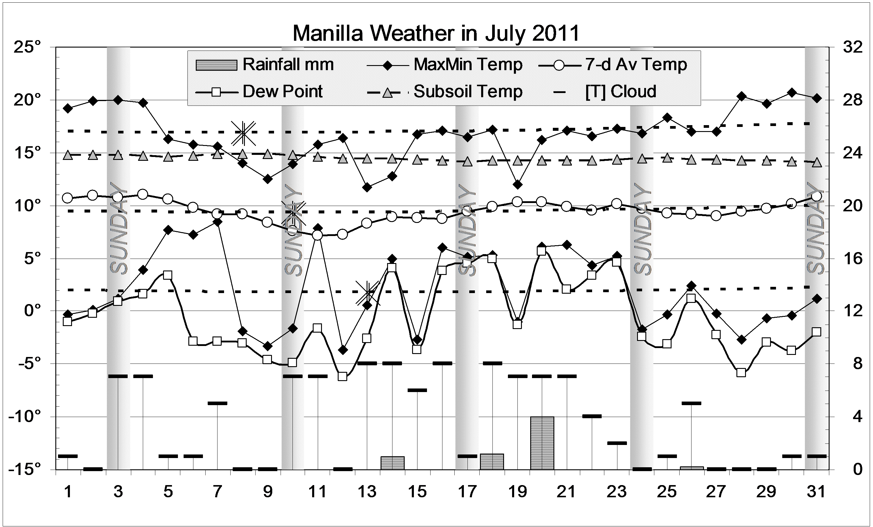
Despite a series of cloudy cold days in the middle of the month, most features of the weather in July were normal. Days got as warm as 20° at each end of the month, and never went lower than 11.7°. Nights were neither very warm nor very cold. There were 17 frosts, the coldest being -3.7°.
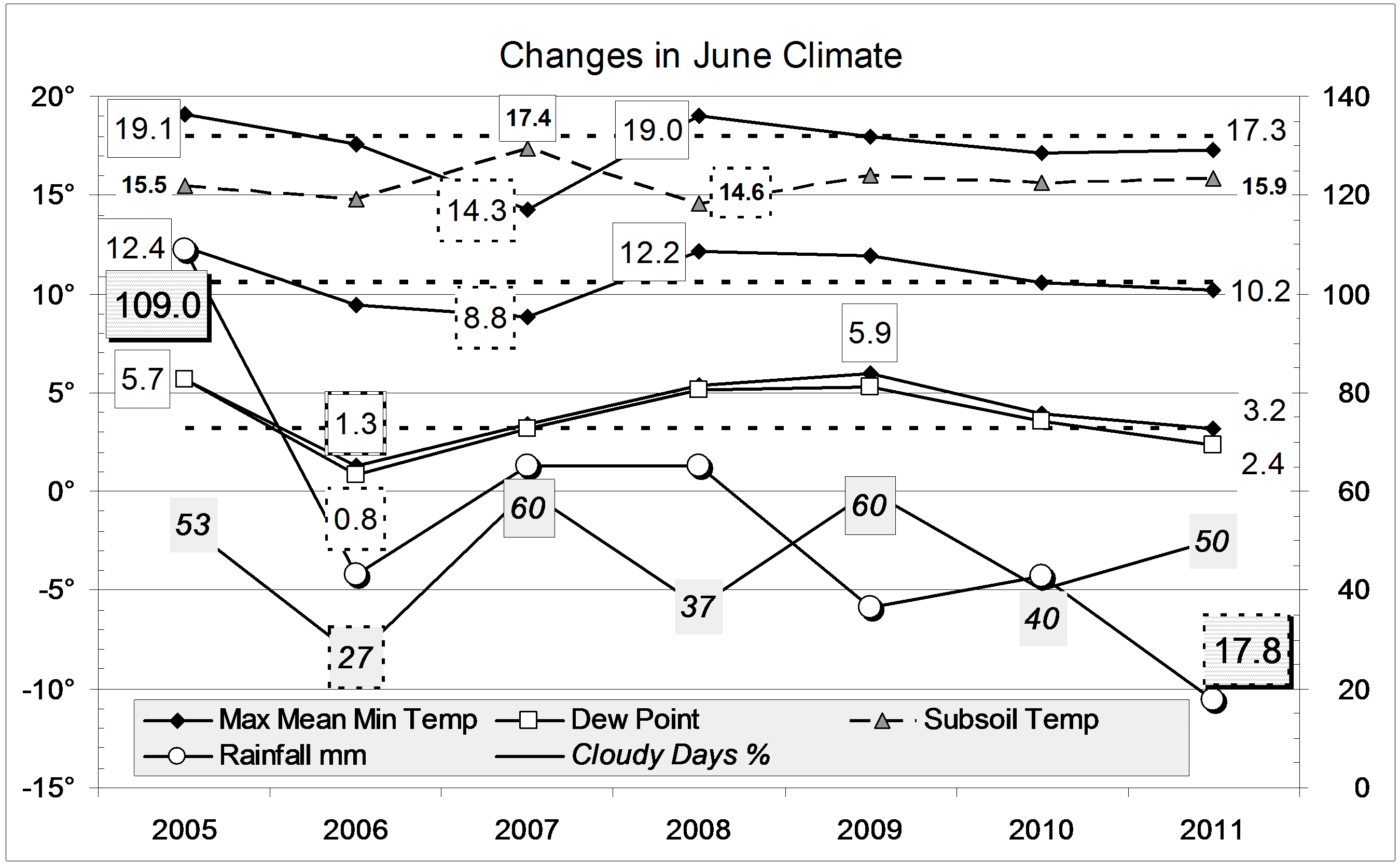
Humidity and rainfall recall the drought year of 2002.
Extremely low humidity was shown by the early morning Dew Point on the 12th, of 6.2°. This was the lowest July value since 2002, which had four lower values, down to 6.7°.
The highest rainfall reading was only 4 mm, recorded on the 20th. Four rain days totalled 6.4 mm.By the end of the month there had been 39 days with less than 5 mm of rain.

 Comparing July monthsClimate July 2011.

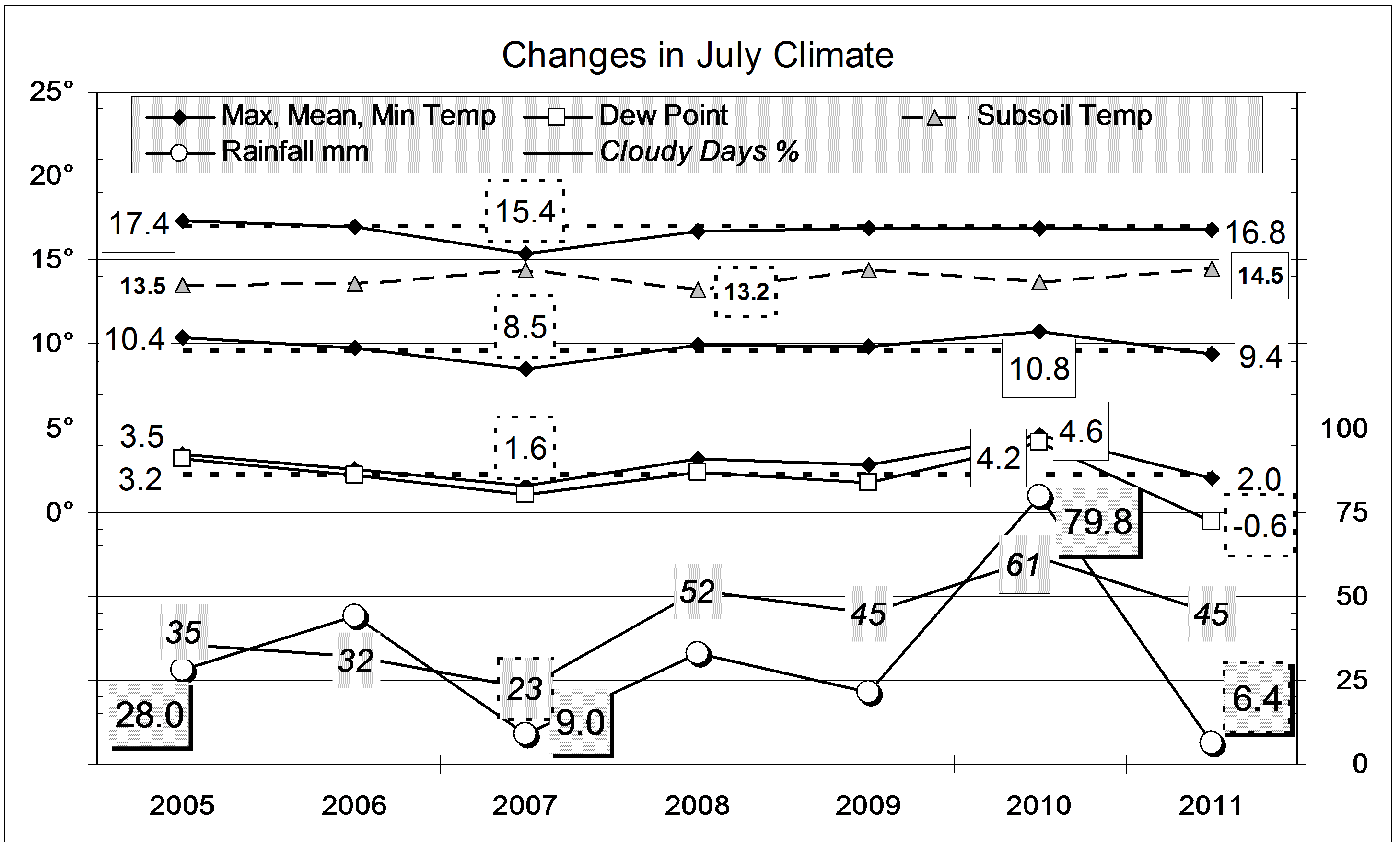
Mean temperature readings were normal. The mean early morning Dew Point (- 0.6°) was the lowest July value since 2002 (- 1.4°).
For frosts, this month was normal. Since 1999, the most frosty July was in 2002, with 27 frosts, down to -5.1°. The least frosty was 2010, with 12 frosts, down to only -1.4°.
The rainfall of 6.4 mm is very low: on the 8th percentile for July. Only ten Julies in 127 years have been drier. (July 2002 and July 1940 were equal driest, at 1 mm.) Rainfall totals for 2, 3, 4 and 5 months are in the 5th, 10th, 9th and 10th percentiles respectively. Percentile values lower than 10 are serious rainfall shortages. Totals for larger groups of months continue to be near normal.


Data. Rainfall data is from Manilla Post Office, courtesy of Phil Pinch. Temperatures, including subsoil at 750 mm, and other data are from 3 Monash Street, Manilla.


One year of House Performance: II

Graphical 1-year record of outdoor and indoor mean temperatures, subsoil and heat bank.

See also “One Year of House Performance: I”.

Like the graph in the post linked above, this is a log of indoor and outdoor 7-day mean temperatures at my low-energy solar-passive house at Manilla, NSW.
In place of the curves for normal air temperature and comfort zone limits, this graph includes two (raw value) logs of subsoil temperature at 750 mm below the surface. The green trace is the subsoil temperature outdoors in the garden. The orange trace is that below the middle of the main floor slab. The mass of material below the slab is surrounded by insulation at the edge so as to form a “heat bank”.

Continue reading

One year of House Performance: I

Graphical 1-year record of outdoor and indoor mean temperatures with the comfort zone

This graph is a log of indoor and outdoor 7-day mean temperatures at my low-energy solar-passive house at Manilla, NSW. Indoor mean temperatures are in red, and outdoor mean temperatures in black. Both logs show the same cycles of temperature with a period of two to three weeks. Indoor cycles have a much smaller amplitude.

Continue reading

3-year trends to June 2011.

Parametric plots of smoothed climate variables at Manilla

“Dry air but not warm or sunny”Trends to June 2011.

Raw anomaly data for June 2011 (shown in orange) are a little strange.
Daily max temperature, shown on the x-axis of all six graphs, has stalled without quite rising to normal from the extreme cold of last October.
Two variables indicate severe drought: Rainfall was very low, and so was the early morning Dew Point.
Most other variables are near normal, or slightly to the “flooding rains” side of normal.
Percent of cloudy mornings (>4 Octas) remains stable at a very high positive anomaly. For a calendar month that had 35% cloudy mornings in the reference decade beginning in 1999, it now has 55% cloudy mornings.

Note: Fully smoothed data – Gaussian smoothing with half-width 6 months – are plotted in red, partly smoothed data uncoloured, and raw data for the last data point in orange. January data points are marked by squares. Blue diamonds and the dashed blue rectangle show the extreme values in the fully smoothed data record since September 1999.

June 2011 rather cool and dry

The daily weather logWeather log June 2011.

June began and ended with warm sunny days. The second week was cold: the 9th had a maximum of only 12° after a frosty night of -2.7°. Days from the 12th to the 15th were not much warmer, made miserable by overcast and rain, but the nights were warm. The 8/8 cloud recorded on the morning of the 24th was fog, which cleared to a blue sky at 10:45.
The highest rainfall reading was only 8 mm, recorded on the 22nd. Five rain days totalled 17.8 mm.

 Comparing June monthsClimate June 2011.

Of the mean temperature readings, only the mean daily maximum was a bit lower than usual. Days were not as cold as in June 2007. This time, there were 14 frosts, which is near the decade average.
The rainfall of 17.8 mm is rather low: on the 20th percentile for June. (The long-term June average is 44.3 mm.) June rainfalls have fallen rather steadily since June 2005, the sixth wettest on record at 109 mm. Nearly all rainfall totals for groups of months (up to 360 months) continue to be near normal. Only those for three months and four months are below the 25th percentile.


Data. Rainfall data is from Manilla Post Office, courtesy of Phil Pinch. Temperatures, including subsoil at 750 mm, and other data are from 3 Monash Street, Manilla.