September 2011: Dry Air with Rain

Humidity this month was extremely low. Early morning Dew Point readings averaged 1.7°, which is 3.7° below normal for September (5.4°). Relative humidity at sunrise was about 70% instead of 80%, and in the heat of the day 25% instead of 35%. This is the sixth month in a row with very low humidity, beginning with April, which had Dew Points 1.5° below normal.
In thirteen years only three months have had Dew Points further below normal. They were: July 2002 (down 3.8°), October 2002 (down 3.9°), and May 2006 (down 3.9°).
Plants are stressed by such dry air, and litter will burn easily.

The daily weather logWeather log September 2011.

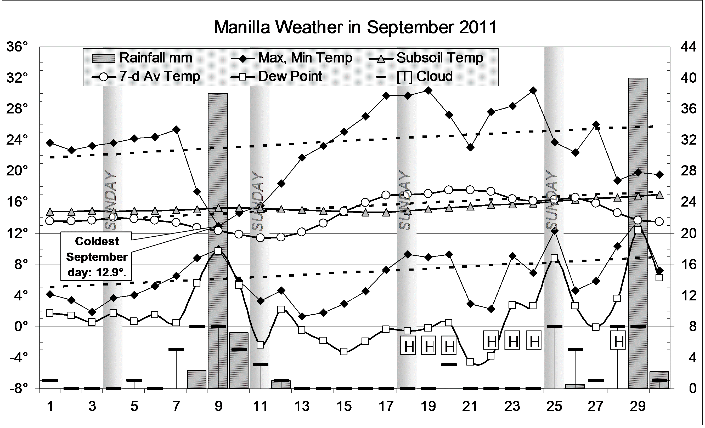
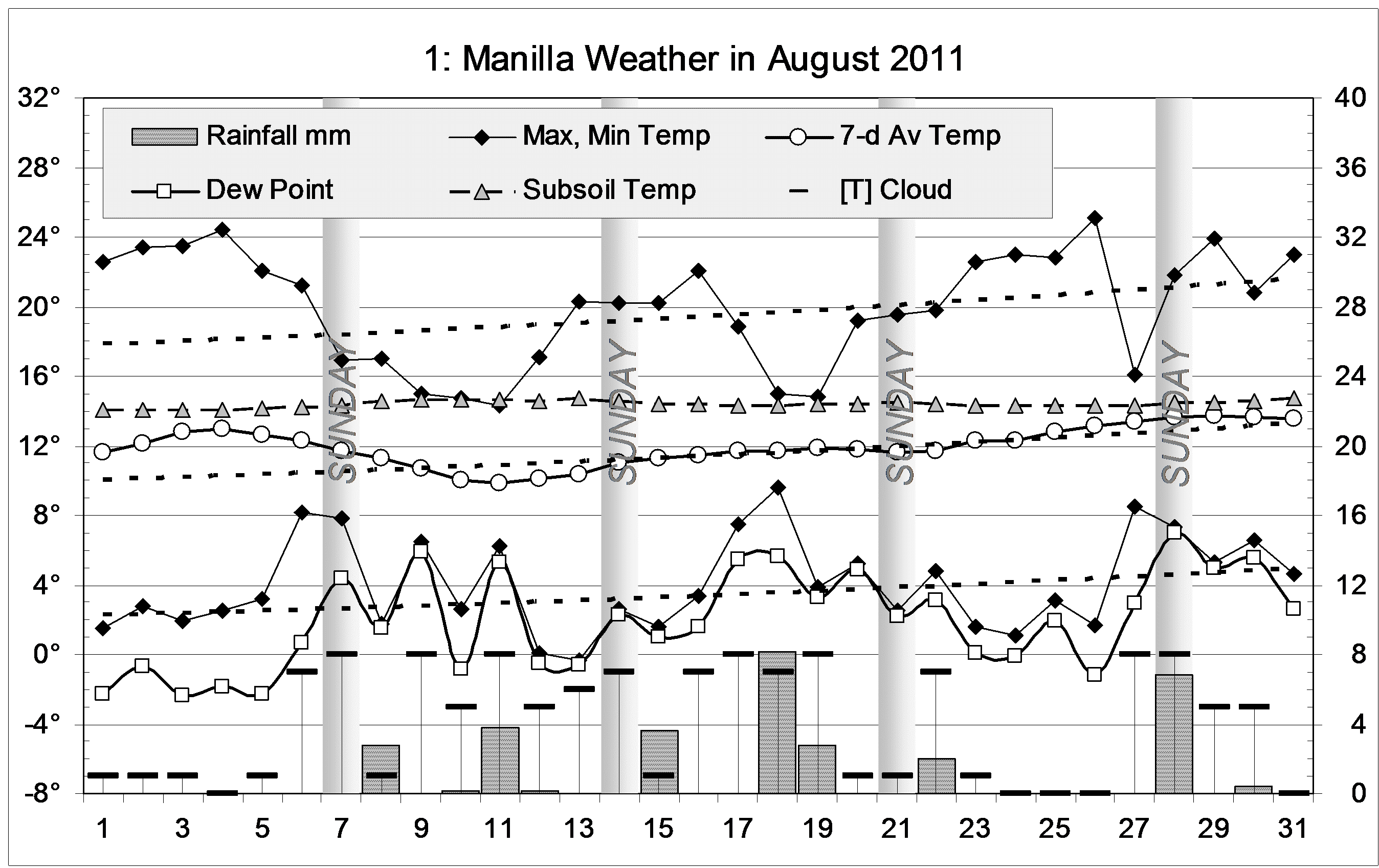
Most September days were warm and sunny, but heavy rain registered on the 9th (38 mm) and on the 29th (40 mm) brought cold windy overcast weather. The 9th, at 12.9°, was the coldest September day on this record. There had been no days colder than 14°.
While many days had no cloud at all, seven days (marked “H”) had a thick smoke haze from Queensland.

 Comparing September monthsClimate September 2011.

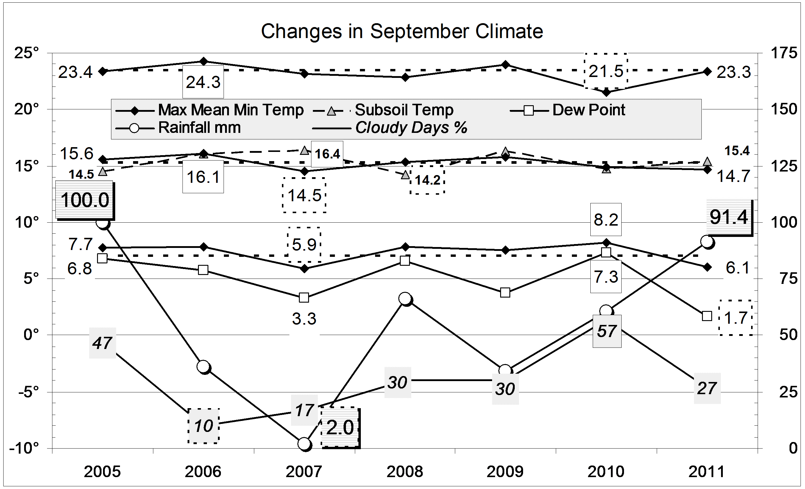
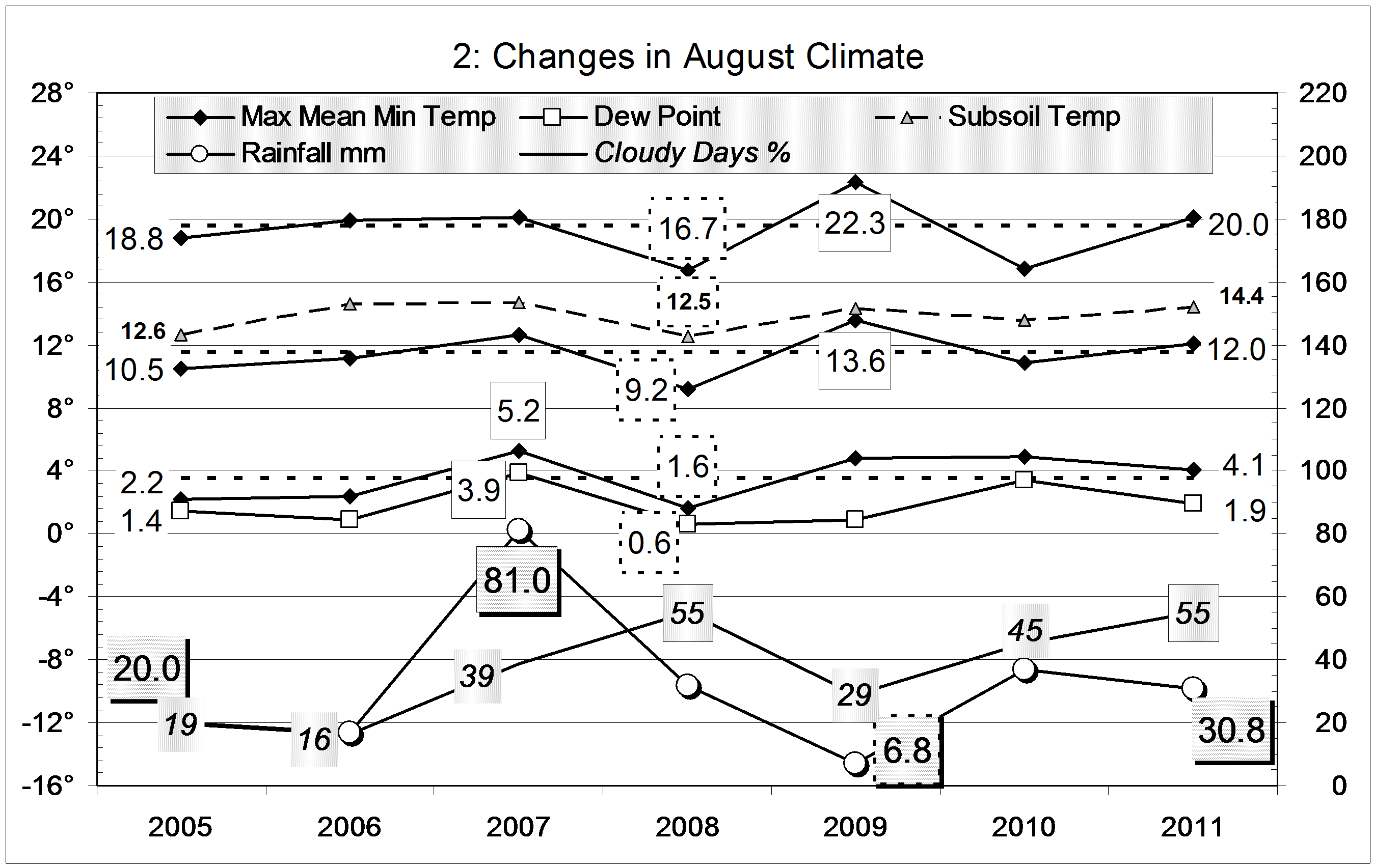
Mean temperature readings were below normal by half a degree or more. The extremely low mean early morning Dew Point (1.7°) contrasts with the very high value last September: 7.3°
Twenty-seven percent cloudy mornings is a normal value, but lower than in the last three Septembers.
The rainfall of 91.4 mm is extremely high, in the 94th percentile for September (Average: 41.1 mm.). Rainfall totals for groups of months are all near normal. The nearest to a “drought” is the 6-month total (221 mm) which is in the 21st percentile; the nearest to a “deluge: is the 12-month total (724 mm) which is in the 68th percentile.


Data. Rainfall data is from Manilla Post Office, courtesy of Phil Pinch. Temperatures, including subsoil at 750 mm, and other data are from 3 Monash Street, Manilla.

Winter 2011 extremely dry

Weather log winter 2011
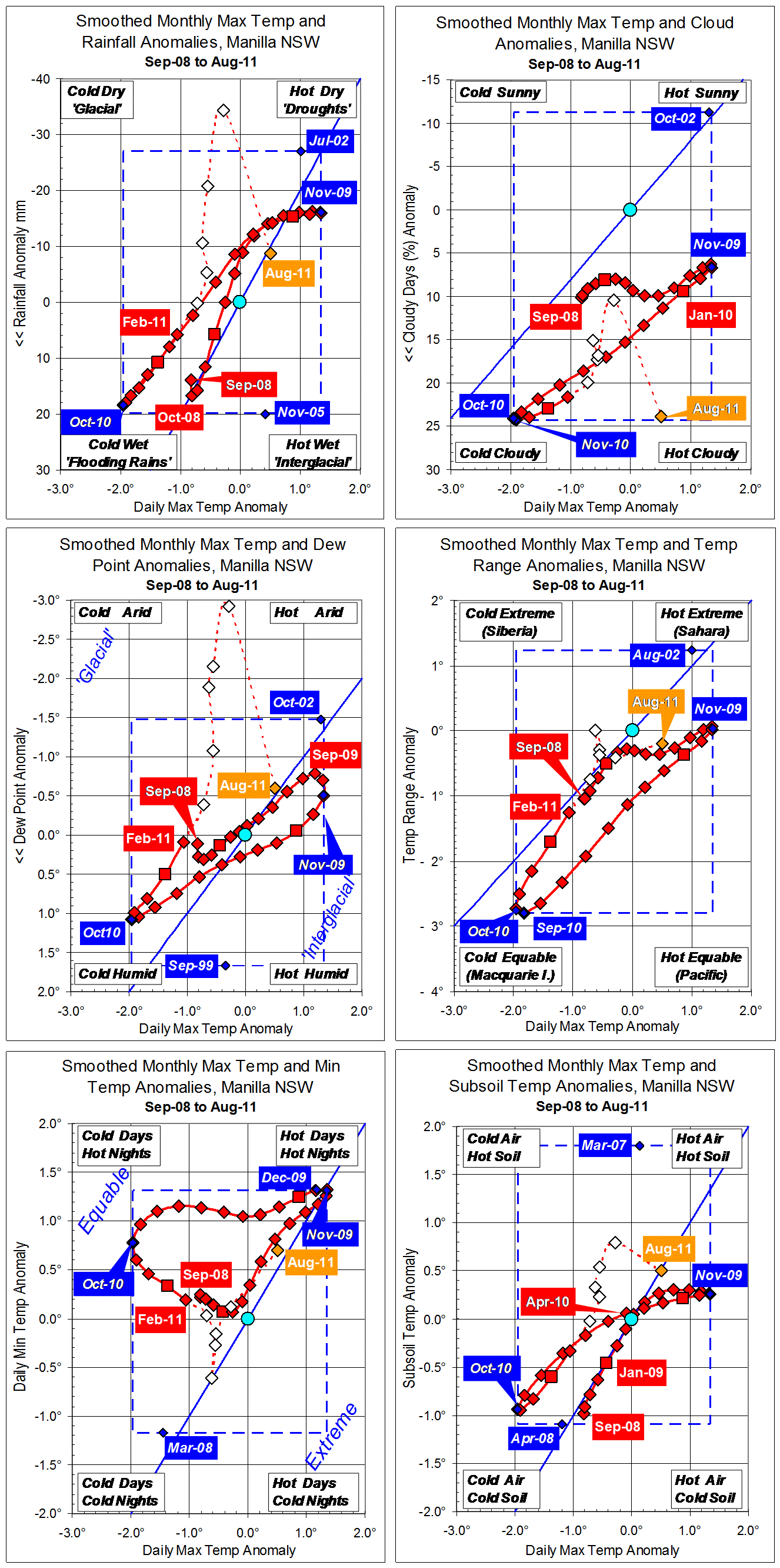
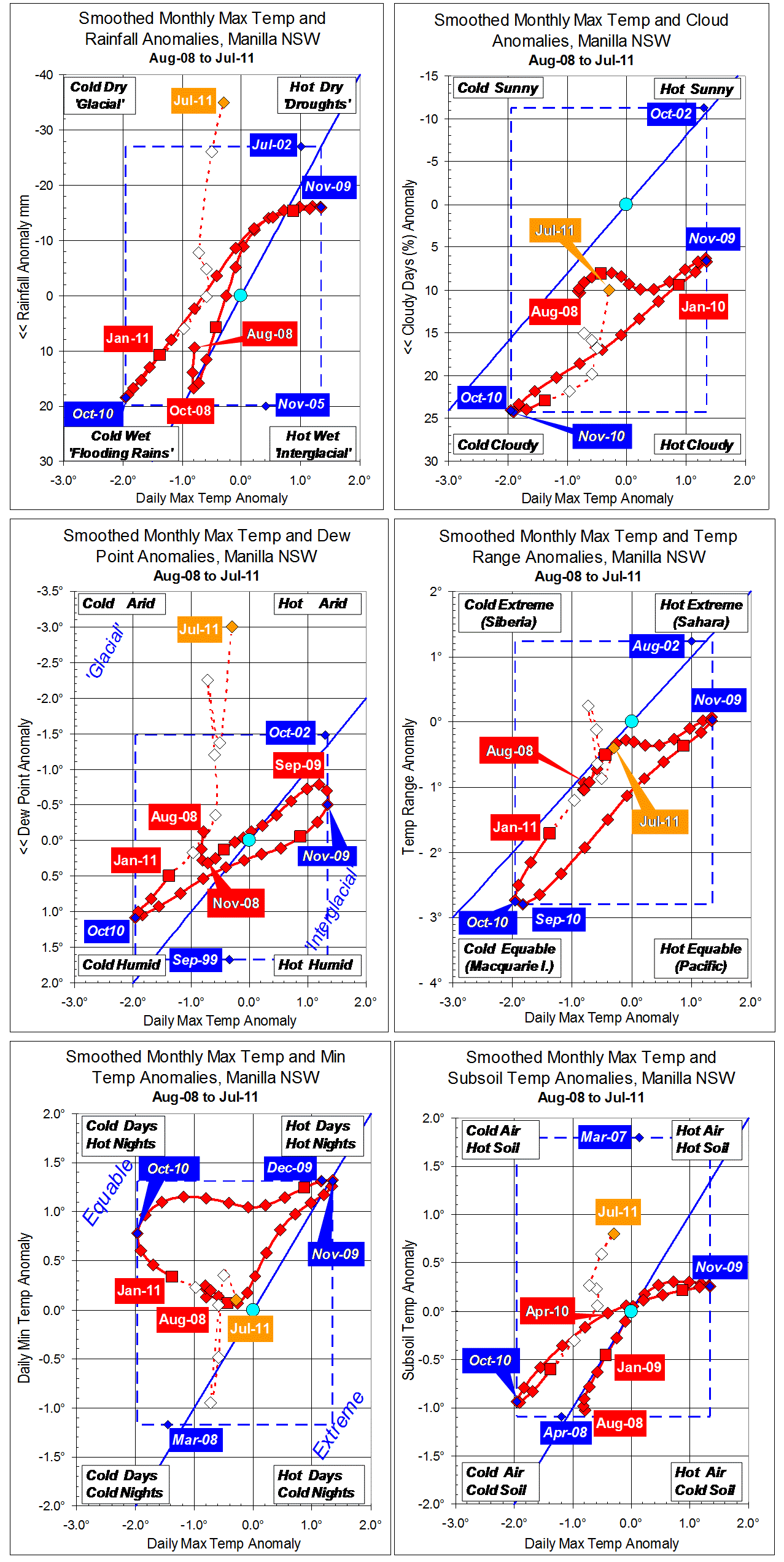
For temperature, this winter was normal. Otherwise, it was strange: it had the extreme low rainfall and low humidity that come with drought, without sunny skies or severe winter frosts.
During the season, two spells of weather stood out. In mid-June cool days and very warm nights came with rain, cloud, and high humidity. The last days of July and the first week of August had very warm sunny days with very low humidity. A mid-winter spell of cold weather in mid-July was not much colder than that in early June.
The number of frosts (40) was below the average number (44). The coldest screen reading was -3.7°, exactly on the average.
The percentage of mornings with more than 4/8 cloud (50%) was a new record for winter. Winters in 2008, 2009, and 2010 had percentages in the high forties, compared with the earlier average of 34%. On four mornings fog did not clear until late; five others had some fog in the valley.
Humidity was extremely low, marked by a mean early-morning Dew Point of 1.2°, the lowest winter mean on this record.
There were 19 rain days, which is normal. However, falls were extremely light: the highest daily reading of 8.2 mm was by far the lowest maximum reading in 13 winters. The winter total of 55.0 mm is in the 11th percentile: it was the 14th driest winter on record, only slightly wetter than that in the extreme drought year 2002 (44.6 mm).Climate winter 2011

Data. Rainfall data is from Manilla Post Office, courtesy of Phil Pinch. Temperatures, including subsoil at 750 mm, and other data are from 3 Monash Street, Manilla.

3-year trends to August 2011.

Parametric plots of smoothed climate variables at Manilla

“Summer showed warming and drying”Trends to August 2011.

New fully-smoothed data for summer 2010-11

Daily maximum temperature anomalies (x-axis, all graphs) are more clearly shown on the top right graph. They rose at 0.3° per month: about the same rate as they had fallen in the winter. From the extreme cold (-1.96°) of October 2010, the February value was half-way back to normal.

Monthly rainfall anomalies (y-axis, top left graph) decreased through summer, exactly reversing the winter trend.

Cloudiness (top right graph) also reversed the trend seen in winter but, for a given temperature value, there was now more cloud.

Dew Point anomaly (centre left) fell much more rapidly than it had risen in winter. It was near normal by February.

Temperature range anomaly (centre right) rose much more rapidly during summer than that of maximum temperature, and reached higher values. As has appeared persistently in this data series, temperature range is the first variable to reach a positive or negative peak anomaly value. Here, its minimum value was in September, a month before the minimum value of daily maximum temperature. On these axes, the curve loops clock-wise as a result.
Daily minimum temperature anomaly (bottom left) fell steadily towards normal through spring and summer, completing a broad 30-month loop with daily maximum temperature anomaly.

Subsoil temperature anomaly (bottom right) fell along with daily maximum temperature anomaly.

Partially smoothed and unsmoothed data since February

Early winter 2011 had very low rainfall, very low Dew Points, and warm subsoil. Raw anomaly values for August suggest that the climate has since returned to normal, if somewhat warm and dry.

Note: Fully smoothed data – Gaussian smoothing with half-width 6 months – are plotted in red, partly smoothed data uncoloured, and raw data for the last data point in orange. January data points are marked by squares. Blue diamonds and the dashed blue rectangle show the extreme values in the fully smoothed data record since September 1999.

August 2011: rain still scarce

The daily weather logWeather log August 2011.

There were warm sunny days early and late in the month. Otherwise, days were often cold and cloudy, with a bit of rain. Of four foggy mornings, the 28th had fog that kept visibility below 800 metres until 11 am.
Temperatures were never far from normal. Two years ago, August 2009 had one daily maximum (31.8°) which was 11.4° above normal and one daily minimum (18.2°) which was 14.0° above normal.
The highest rainfall reading was quite low: 8.2 mm, recorded on the 18th. There were ten rain days, four more than usual, but the total was only 30.8 mm.

 Comparing August monthsClimate August 2011.

Mean temperature readings were above normal by half a degree. The mean early morning Dew Point (1.9°) was 0.6° lower than normal, indicating low humidity.
With only nine frosts (below +2.2° in the Gill screen), this was the least frosty August of thirteen.
Fifty-five percent cloudy mornings equalled the August record, set in 2008.
The rainfall of 30.8 mm is fairly low, in the 44th percentile for August. Rainfall totals for 3, 4, 5 and 6 months have percentile values lower than 10, making them serious rainfall shortages. Totals for larger groups of months continue to be near normal. The 12-month total (691 mm) is well above the median, being in the 61st percentile.


Data. Rainfall data is from Manilla Post Office, courtesy of Phil Pinch. Temperatures, including subsoil at 750 mm, and other data are from 3 Monash Street, Manilla.


3-year trends to July 2011.

Parametric plots of smoothed climate variables at Manilla

“Dry air and little rain”Trends to July 2011.

These graphs have data points for the last 36 months. In that time, the climate at Manilla, NSW has experienced a cycle from near-normal (Aug-08), through very warm and dry (Nov-09), then very cool and wet (Oct-10) , and back to near normal (Jul-11). For most variables, the raw anomaly values of July 2011 are near the smoothed anomaly values for August 2008.

Three variables have not returned to normal. Rainfall and Dew Point are far below normal, as typical in drought, and Subsoil temperature is high.
Cloudiness is “normal” in the new cloudy regimen in place since September 2007.

Note: Fully smoothed data – Gaussian smoothing with half-width 6 months – are plotted in red, partly smoothed data uncoloured, and raw data for the last data point in orange. January data points are marked by squares. Blue diamonds and the dashed blue rectangle show the extreme values in the fully smoothed data record since September 1999.