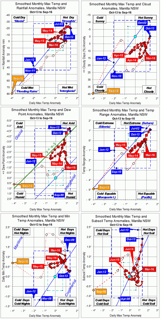
3-year trends to October 2016

Parametric plots of smoothed climate variables at Manilla
“October 2016 still cold”

Trends to October 2016

October raw anomaly data (orange)

In October 2016 daily maximum air temperature continued extremely low. Now daily minimum air temperature and subsoil temperature (bottom graphs) also became extremely low. Most other variables returned to near normal.

 Fully smoothed data (red)

The latest fully-smoothed data point is April 2016.
By then, most anomalies were moving definitely towards cool and moist. However, daily minimum temperature and subsoil temperature were rising.
In April 2016, the smoothed anomaly of daily minimum temperature was extremely high. It was approaching the 18-year record value of +1.32°, set in December 2009.


Note:

Fully smoothed data – Gaussian smoothing with half-width 6 months – are plotted in red, partly smoothed data uncoloured, and raw data for the last data point in orange. January data points are marked by squares.
Blue diamonds and the dashed blue rectangle show the extreme values in the fully smoothed data record since September 1999.

Normal values are based on averages for the decade from March 1999.* They appear on these graphs as a turquoise (turquoise) circle at the origin (0,0). A range of anomalies called “normal” is shown by a dashed rectangle in aqua (aqua). For values in degrees, the assigned normal range is +/-0.7°; for cloudiness, +/-7%; for monthly rainfall, +/-14 mm.

 * Normal values for rainfall are based on averages for the 125 years beginning 1883.

Is There Any Drought Now?

No. In Manilla just now, there is no drought of any kind: not a short drought, a medium-length drought, or a long drought; not an extreme drought, a severe drought, or even just a serious drought.

A new comprehensive graph of the severity of drought at one site.

In this graph, each line of data points is for one particular month. The middle line, joining the red squares, shows the whole rainfall drought situation for last month: September 2016.
This is a new kind of graph. (See Note 1 below.) It can show how severe a drought is, not only during the last month or two, but during the last year, and during the last many years. That is a lot of information.

How to read the graph

A month of extreme drought would have data points very low down on the graph. The scale on the left side is amount of rainfall. It must be a “percentile” value. For example: if the amount of rain that fell is just more than has been seen in the driest 5% of all months, it has a value in the 5th percentile. (See Note 2 below.)

Along the top and bottom of the graph I have plotted a number of months.
The number does not show time passing. It shows the number of months I included in a calculation. For each month on record I did many calculations. I added up the total rainfall for:
* the month itself;
* two months including the previous month;
* three months including the month before that;
* … and so on.
I found the totals for larger groups of months extending back as far as 360 months (30 years).
Using all these rainfall totals, I calculated percentile values to plot on the graph. For example, for groups of 12 months, all groups of 12 consecutive months are compared with each other, to find the percentile value of the 12-month period ending in a given month. (See Note 3 below.)

Which months had the most drought and least drought?

The worst drought there could ever have been would be one with data points along the bottom line of the graph. In such a disastrous month, all the rainfall totals would be the lowest on record, not just the one-month total, but also the two-month total and so on up to the 360-month total. Every one of them would be the lowest total on record. It has never been as bad as that.
The “best” time, in terms of being free of drought, would be a month with all its data points along the top edge of the graph. For that month, every rainfall total, for a short period or a long period, would be the wettest on record.
From the Manilla rainfall record, I have chosen to display the most drought and the least drought that actually occurred.

The most drought: August 1946

The month of August 1946 had no rain. Of course, that was the lowest rainfall for any August month (One among 13 months on record that had no rain.). As a result, the percentile rank for that month’s rainfall is zero. Most totals for groups of any number of months ending in August 1946 are also on the “zero-th” percentile, that is, the lowest on record. Thus, it was an extreme drought in the short term, medium term and long term.
For this month, percentile values that are above the third percentile occur in the totals for 48, 60, and 72 months, as shown. These figures, while not extremely low, were still well below normal (Normal is the 50th percentile.). They occur because these totals include some wet months in 1940, 1941, and 1942.

The least drought: March 1894

March 1894, with 295 mm of rain, was one of the the wettest months ever, ensuring a 100th percentile value. The rainfall totals for groups of months ending in that month included six other “wettest ever” values, and all other groups of months were also very wet. No group of months was below the 95th percentile. (See Note 4 below.)

Current drought situation (September 2016)

This month’s rainfall total of 122.4 mm puts it in the 92nd percentile of all monthly rainfall values, far above the median value marked as “normal” on the graph. The 2-month rainfall total (203 mm), and the 4-month rainfall total (350 mm) are almost as high, each in the 90th percentile.
Continue reading

Solar-passive House Testimonials

Photo of a birthday party in the solar-passive house

Birthday Group

Family members visited the solar-passive house in Monash Street, Manilla, NSW, in Mid-winter 2016. The date of their visit is shown on the graph in this earlier post. This photo shows us dressed for comfort at 17 degrees indoors.

Interviewer:
What do you think of Grandpa’s house in winter?

Grand-son (10):
I like Grandpa’s house. It’s nice. Except there’s no wifi. But apart from that, it’s good.

Grand-daughter (13):
Grandpa’s house? It’s cool. It’s interesting. Awesome curtains – I get a shock when they move because I’m not used to it. The garden is cool too – it’s pretty.

Daughter:
I love winter. And I love visiting my Dad. He built this really great house in Manilla nearly twenty years ago. Prior to that, he was tenanted in an old office space above the newsagent. I loved visiting him back then as well, even if his flat was super hot in summer and not at all cosy in winter. The house he built is wonderful all year round.

Even if there are only a few hours of sun each day in the depths of a NSW winter, that is all you need to warm my dad’s house. You can find yourself a chair in the sun, sit for a while and imagine you’re on vacation in Hawaii. Only with much better coffee. As the sun goes down, the sound of noisy birds settling in for the night comes through from outside.

Kitchen view SW

Kitchen view SW

The kitchen is well-stocked for preparing dinner (especially after we restock it) and, once the stove is on, it’s toasty warm in there. There is a curtain that closes the kitchen off from the rest of the house, but cooking time is social time for us, so we leave it open – which also helps flood the house with the delicious smells of curry. The house finally gets coolish sometime after dinner. That’s when we don the cardies and fluffy slippers and pre-heat the beds. The electric blankets, even on low, manage to warm the bedrooms all night.

Next morning, on a strict schedule, the automatic curtains fly open to announce the new day. Not being an early-morning person, I make good use of the curtain override button. At least, until I get the first whiff of toast.

Son-in-law:
Having grown up in India, I find summer is a breeze and cold weather is a challenge. After a couple of decades in Canberra and almost a decade in Switzerland, I have finally realised that dealing with winter boils down to managing the environment in the house and wearing the right gear.

I have stayed in my father-in-law’s house in Manilla several times, in summer and in winter, most recently in the winter of 2016. The house is comfortable in both summer and winter. I remember feeling colder in winter when I first stayed there compared with now – I am not sure whether the house is warmer, or I have more layers of fat to protect me as I get older. Maybe I just dress more appropriately now for winter thanks to my time in Switzerland.

The place where we hang out the most is the kitchen, and around the kitchen table, over cups of coffee or improvised meals, catching up on left and right leaning newspapers. The kitchen is very cozy in winter, especially when there are multiple dishes cooking away on the stove.

A memorable feature of my father-in-law’s house is the automated curtains which felt space-age when I first experienced them, but now I am used to them. They are like a bell-less morning alarm. Being a morning person, I beat them to it, and am awake before they start moving and letting in light.

Photos of porch awnings adjusted for outdoor living in winter and in summerI love the balcony on the first floor. It is well protected and I can sit there for hours with a cup of coffee and a book, and listen to cockatoos and other birds, and watch the paragliders in the distance when they are out. In winters the mid to late afternoons are the most comfortable.

Photo of a path between trees

In the garden

As the trees and shrubs in the evolving garden have grown and the paths have become more structured it has become a wonderful place to walk around and to relax. The garden bench is particularly inviting. This man is as passionate about his garden as he is about his house. The guided tour of his garden is one of the highlights of our stay there.

Interviewer:
Thank you all for your answers.
Goodnight, everyone.


Recent photos of the house and garden are here.

September 2016 had near-record rain

Blooms of Acacia paradoxa

Kangaroo Thorn

There were fourteen rainy days in a month that ended no warmer than it began. The month of September normally warms up by nearly four degrees. This time it remained near 14° all month. Some plants encouraged by the plentiful moisture were discouraged by the cold.
The highest daily rainfall reading, 28.8 mm on the 14th, hardly compares with one of 71.1 mm in 2005, or even one of 40.0 mm in 2011.
No days were warm. For the first time in this 18-year record, no September day reached 25°. More days than ever (18) were below 20° but not one was as low as 15°. Temperatures at night were near normal. A frost on the 5th was the only one. It may have been the last of the year, about a fortnight earlier than usual.
Only four mornings this month had no cloud, while seven were totally overcast.

Weather log for September 2016

Comparing September months

For monthly average temperatures, the daily maximum of 19.7° stands out as a record low, 4.1° below normal. Three indicators for moisture reached their extreme September values for the new century: rainfall, percentage of cloudy mornings (63%), and (narrowest) daily temperature range (12.0°). Dew point (6.0°) was just above normal, but very much higher than in September months since 2010.
The monthly rainfall total of 122.4 mm (amended) was one of the four highest ever September readings. The others were: 1917: 124 mm; 1949: 126 mm; 1998: 166 mm.
There are not now any noteworthy shortages in rainfall totals for any number of months, up to 360 months (thirty years).

Climate for September 2016


Data. Rainfall figures for this month are from the automatic rain gauge at Manilla, published on the internet by the Bureau of Meteorology as Station 55031. All other data, including subsoil at 750 mm, are from 3 Monash Street, Manilla.

3-year trends to September 2016

Parametric plots of smoothed climate variables at Manilla
“September 2016 extreme cold and rain”

Trends to September 2016

September raw anomaly data (orange)

September 2016 was extremely wet and had extremely cold days. Axes on the graph had to be extended to anomaly values of minus 80 mm for rainfall and minus four degrees for daily maximum temperature. In sympathy, cloudiness and dew point were extremely high and daily temperature range was extremely low.
On the first graph, partially-smoothed rainfall and temperature values had moved consistently in the same direction since March.

 Fully smoothed data (red)

The latest fully-smoothed data point is March 2016.
Rainfall, temperature range anomaly and daily maximum temperature had been static for three months. The latter had been rather high, the others normal. Cloudiness, dew point and temperature range had begun to move down the graph, while daily minimum temperature and subsoil temperature had begun to move up.


Note:

Fully smoothed data – Gaussian smoothing with half-width 6 months – are plotted in red, partly smoothed data uncoloured, and raw data for the last data point in orange. January data points are marked by squares.
Blue diamonds and the dashed blue rectangle show the extreme values in the fully smoothed data record since September 1999.

Normal values are based on averages for the decade from March 1999.* They appear on these graphs as a turquoise (turquoise) circle at the origin (0,0). A range of anomalies called “normal” is shown by a dashed rectangle in aqua (aqua). For values in degrees, the assigned normal range is +/-0.7°; for cloudiness, +/-7%; for monthly rainfall, +/-14 mm.

 * Normal values for rainfall are based on averages for the 125 years beginning 1883.