Manilla’s Frosts

I have a 13 year record that shows how frosty Manilla is, and how some years are frostier than others. My thermometer is on high ground, so people living where cold air collects will have had more frosts. However, my readings show changes from one time to another. As I do not have a thermometer in the grass, I have recorded a frost when my screen reading is below +2.2°.

There is a matching post for Manilla’s hot days.
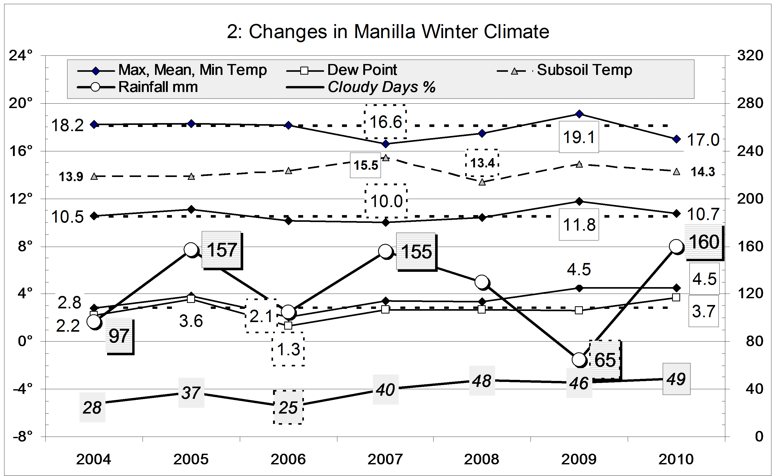
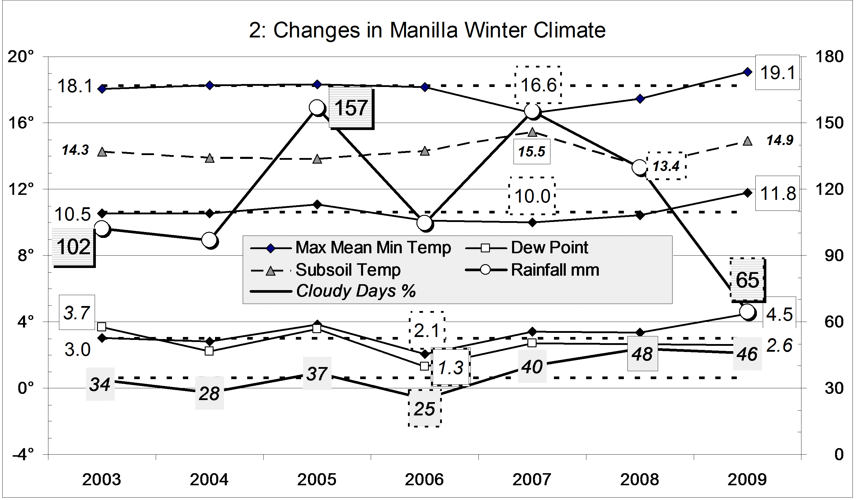
Total frosts

The first graph shows the number of frosty mornings in each year. The most frosts were in the years 2004 (68) and 2006 (70); the fewest were in the years 2007 (43) and 2010 (44). The 13-year average is 54.
The graph also shows the number of mornings colder than zero, minus two, and minus four degrees. On the average, these occurred on 26, 7, and 1 mornings per year. For those colder than zero degrees, 2006 was again the frostiest, but 2002 was also very frosty. Counting only the most severe frosts (below minus two or minus four degrees) 2002 was the frostiest year. It had the coldest mornings: -5.1° on both the 2nd and 11th of July.Frosts each year, and seasonal distribution.

Frosty months

The second graph shows how most frosts come in the winter months, especially July, with some frosts in autumn, but few in spring and none in summer. Few come before Anzac Day (25th April) or after Labour Day (first Monday in October in NSW).


The graphs below show that each year was different. The drought year 2002 had the highest number of frosts in a single month: 27 in July – half of all frosts in that year. By contrast, the 70 frosts of 2006 were spread through the months of winter and autumn: there were more frosts in June and August than in July. Continue reading

Winter 2011 extremely dry

Weather log winter 2011
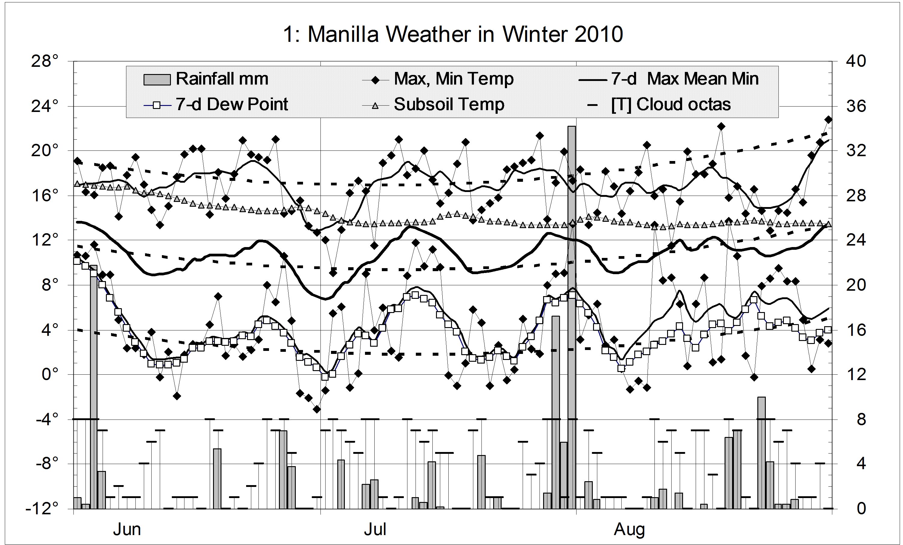
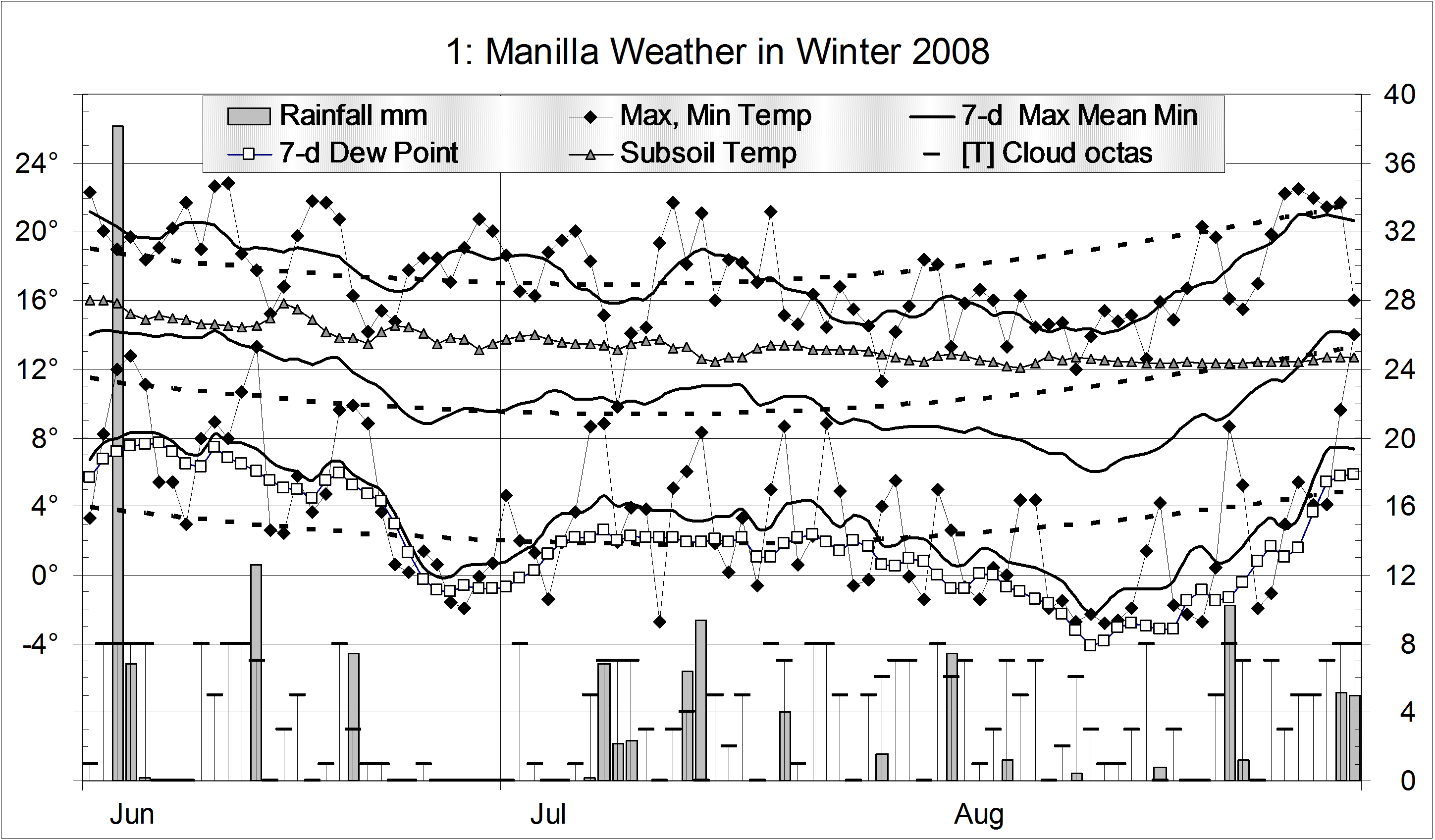
For temperature, this winter was normal. Otherwise, it was strange: it had the extreme low rainfall and low humidity that come with drought, without sunny skies or severe winter frosts.
During the season, two spells of weather stood out. In mid-June cool days and very warm nights came with rain, cloud, and high humidity. The last days of July and the first week of August had very warm sunny days with very low humidity. A mid-winter spell of cold weather in mid-July was not much colder than that in early June.
The number of frosts (40) was below the average number (44). The coldest screen reading was -3.7°, exactly on the average.
The percentage of mornings with more than 4/8 cloud (50%) was a new record for winter. Winters in 2008, 2009, and 2010 had percentages in the high forties, compared with the earlier average of 34%. On four mornings fog did not clear until late; five others had some fog in the valley.
Humidity was extremely low, marked by a mean early-morning Dew Point of 1.2°, the lowest winter mean on this record.
There were 19 rain days, which is normal. However, falls were extremely light: the highest daily reading of 8.2 mm was by far the lowest maximum reading in 13 winters. The winter total of 55.0 mm is in the 11th percentile: it was the 14th driest winter on record, only slightly wetter than that in the extreme drought year 2002 (44.6 mm).Climate winter 2011

Data. Rainfall data is from Manilla Post Office, courtesy of Phil Pinch. Temperatures, including subsoil at 750 mm, and other data are from 3 Monash Street, Manilla.

Winter 2010 wet, with few frosts

 An episode of maritime climate

I have posted this seasonal report for winter 2010 on the front page, as a sticky post, to show how the climate of that season was not normal. It was not the average temperature or the rainfall that were unusual. The sky was very cloudy, the humidity very high, and the daily temperature range very low. The climate was equable, as one would expect at a place near the sea: a maritime climate. More in the footnote*

Weather log winter 2010

Temperatures this winter changed little from month to month. June, July and August each had temperatures near the season averages: maximum 17.0°, mean 10.7° and minimum 4.5°. Warm days were rare: only 11 exceeded 20° (usually 25). This winter was even less frosty than the last, with only 32 frosts (usually 44). The lowest minimum was -3.1°.
There were 33 rain days, about twice the usual number.


In terms of daily mean temperature, this winter was normal, However, cool days and warm nights made the daily temperature range (12.5°) narrower than in any winter in the 12-year record. It was also the cloudiest, at 49% cloudy mornings. Manilla’s climate became much more cloudy three years ago, when the average number of cloudy mornings in a month jumped suddenly from nine to twelve (See also these other graphs.). Humidity, as shown by early morning Dew Point was also very high this winter. All these changes reflect a more maritime climate, as on the coast.
Each month would have had rainfall close to average, were it not for one reading of 34.2 mm at the end of July. The total of 160 mm is in the 70th percentile, like that of the wet winters of 2005 and 2007.

Climate winter 2010

*Footnote. The nature of this episode is clear on the 3-year graphs of climate trends, such as that for August 2011. The top left graph shows that, in June, July, and August 2010, rainfall was a little high and daily maximum temperature rather low. The bottom left graph shows the main anomaly: daily minimum temperature remained extremely high while daily maximum rapidly fell, reaching a record low value by October 2010. From July to November that year the difference between daily maximum and daily minimum temperature was some three degrees less than normal.
The middle graph on the right shows directly that the daily temperature range in those months was at record low (narrow) values.

Data. Rainfall data is from Manilla Post Office, courtesy of Phil Pinch. Temperatures, including subsoil at 750 mm, and other data are from 3 Monash Street, Manilla.

Winter 2009 was very warm and dry

Weather log winter 2009

Daily maximum temperatures were mainly above normal throughout the season, except in the second week of June and in mid-July. The values of 31.8° and 30.5° on the 23rd and 24th of August were the hottest winter days in this 11-year record. Many such records were set at that time in Central Australia, southern Queensland and northern NSW. Similarly, daily minimum temperatures were mainly above normal, except in early August. The night-time minimum of 18.2° on 25/8/09 was 2° warmer than the warmest previous winter minimum of 30/8/04.
Early morning Dew Points remained a degree or two below the daily minimum temperature through June and July. In August, they remained low while the temperature soared, so that the air became uncomfortably dry.
There were 20 rain days (usually 18). Most rain came early in the season, with the maximum daily reading only 13.2 mm.
Cloudy mornings declined sharply during the season: June had 60%, July 45%, and August only 29%


Of the last eleven winters, this was the warmest. The daily mean temperature, 11.8°, was 1.2° above normal. The daily minimum, 4.5°, was also the warmest, but the daily maximum, 19.1°, did not reach the 19.2° of winter 2002.

This winter was one of the least frosty, with 39 frosts rather than the usual 44. There was only one reading below minus two, while other winters had from three to nineteen! The mean Dew Point of 1.7° was normal for winter.
The rainfall total of 65 mm is well below average for winter (125 mm). It is in the 13th percentile, much wetter than winter 2002 which, at 45 mm, was in the 7th percentile.
This was the second cloudiest winter of the decade. Forty-six percent of the mornings had more than 4/8 cloud. Last winter was a little cloudier, at 48%.

Climate winter 2009

Data. Rainfall data is from Manilla Post Office, courtesy of Phil Pinch. Dew Point values before August 2005 are from Tamworth Airport 6am data supplied by the Bureau of Meteorology. Temperature and other data are from 3 Monash Street, Manilla.

Winter came very late in 2008*

Weather log winter 2008

The daily weather log

For most of June and July, temperatures were warmer than normal, especially at night. There were a couple of severe frosts in late June, and one in mid-July. The coldest part of winter, however, came extremely late. In the second week of August, both days and nights were six degrees colder than normal. There were more sub-zero nights in August than in June and July together.
Early morning dew points above 7° in early June showed high humidity. Later, dew points below zero showed the air was extremely dry in late June and almost all of August.
The winter was a little less frosty than usual, with 40 frosts rather than the usual 44. There were 24 readings below zero and 7 below minus two, but none below minus four.
There were 21 rain days, totaling 136 mm. Most rain came early in the season. The first rain day, with 38.2 mm, was the wettest winter day in ten years.
July and August were extremely cloudy months, with 52% and 55% cloudy mornings. June, at 37%, was also cloudy.

Comparing winter seasons

Mean daily temperatures (daily maximum, minimum, and mean) were close to normal this winter. Because the maximum was slightly down, and the minimum slightly up, the daily temperature range was reduced. At 14.1°, it was narrower than the normal 15.3° but not extreme like the 13.2° of last winter.
The mean dew point of 1.9° was normal for winter.
The rainfall total of 134 mm is above the long-term average for winter (125 mm). The graph includes the ninth driest winter, 2002. Just ten years ago, 304 mm of rain in the winter of 1998 made it the second wettest on record.
This was the cloudiest winter of the decade. Forty-eight percent of the mornings had more than 4/8 cloud. The winter average is thirty-one percent. The graph suggests a trend to more cloudy winters since 2002.

Climate winter 2008

Data. Rainfall data is from Manilla Post Office, courtesy of Phil Pinch. Dew Point values before August 2005 are from Tamworth Airport 6 am data supplied by the Bureau of Meteorology. Temperatures, including subsoil at 750 mm, and other data are from 3 Monash Street, Manilla.

* The title is a rhyming anapestic tetrameter. With the original “by”-line, it was a rhyming  anapestic hexameter. No-one noticed.