September Climate Anomalies Log

Heat Indicators log for September months

This post is the seventh in a set for the 12 calendar months that began with March. Graphs are sixteen-year logs of the monthly mean anomaly values of nine climate variables for Manilla, NSW, with fitted trend lines. I have explained the method in notes at the foot of the page.

Raw anomaly values for September

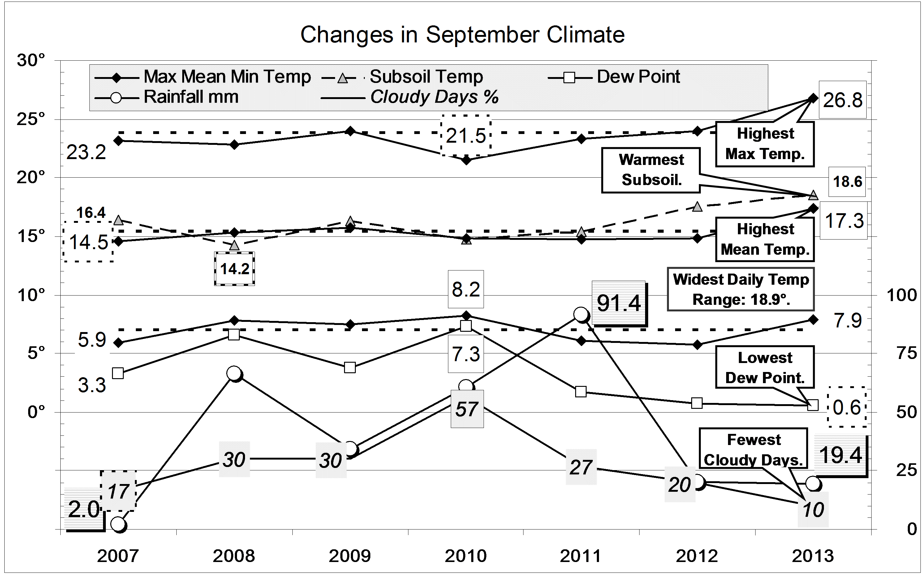
Extreme values of September anomalies in this period were all in the “Moisture Indicators” group:

Temperature range anomaly (minus) +3.6 deg: September 2010;
Cloudy days % anomaly +33%: September 2010;
Dew Point Anomalies (4) -3.8 deg: September 2011, -4.7 deg: September 2012, -4.9 deg: September 2013, -4.1 deg: September 2014.

Trend lines for September

Heat Indicators

The trend of daily maximum temperature anomalies was concave, with a minimum at 2007. The trend of mean temperature anomalies was similar, but less concave. The trend of minimum temperature anomaly was almost straight, but had a weak maximum in 2008 and ended low. The subsoil temperature anomaly trend was parallel to that of the daily maximum, but higher.

Moisture Indicators log for September months

Continue reading

Desert-like September 2013

September was an exceptionally arid month: like the Sahara Desert!

The daily weather logWeather log September 2013

Most days were warmer than normal, with the first 30-degree day of spring coming two weeks early, on Sunday the 8th. Weekly average temperatures showed two warm spells three degrees above normal. Half the mornings had completely blue skies. The air was extremely dry: the dew point early on the 12th was 6.3 degrees below zero, and all the afternoons of the final week had relative humidity below 10%.
Briefly, from the 16th to the 18th, the weather was cooler and more humid, with 19.4 mm of rain.

Comparing September monthsClimate September 2013.

Nearly all the monthly weather values were exceptional. As noted on the graph, they were record September values (from 1999): highest maximum and mean temperatures, widest daily temperature range, lowest dew point and fewest cloudy mornings. (The September daily minimum temperature had been higher: 9.7° in 2002, and 8.2° in 2010.)
The total rainfall of 19.4 mm is half the average of 41.2 mm. It is in the 28th percentile. The two and three month totals are now serious shortages, in the 6th percentile. The 24 month total (1508 mm) and 36 month total (2231 mm) are still very high.


Data. Rainfall data is from Manilla Post Office, courtesy of Phil Pinch. Temperatures, including subsoil at 750 mm, and other data are from 3 Monash Street, Manilla.

3-year trends to September 2012

Parametric plots of smoothed climate variables at Manilla

“Still Very Dry Air”Trends to September 2012.

In September, daily maximum temperatures finally rose above normal. As in August, Dew Points (humidity) remained extremely low, daily minimum temperature very low, rainfall low, and daily temperature range very high. Cloudiness finally fell below normal, and subsoil temperature fell towards normal.

Fully-smoothed data (in red) now include March 2012. All variables for that month show a retreat from the “flooding rains” climate peak. Because the daily minimum temperature anomaly did not reach a minimum in March as I expected, the sequence of peaks for individual variables must be amended as follows:
Nov-11: Rainfall (max); Subsoil temp (min);
Dec-11: Temp range (min); Dew Pt (max);
Jan-12: Temp max (min);
Feb-12: Temp min (min).
The February 2012 value of smoothed minimum daily temperature anomaly (-1.11 degrees) was not quite as low as the record set in March 2008 (-1.17 degrees).

Note: Fully smoothed data – Gaussian smoothing with half-width 6 months – are plotted in red, partly smoothed data uncoloured, and raw data for the last data point in orange. January data points are marked by squares. Blue diamonds and the dashed blue rectangle show the extreme values in the fully smoothed data record since September 1999.

Frosty Dry September 2012

The daily weather logWeather log September 2012.

The severe frost of -2.7° on the 2nd was the coldest September night on this 14-year record. Having ten frosts in the month had not happened before, either. Most were “black frosts” because there was no dew to freeze. The extremely low Dew Point of minus 7.4° on the 2nd has been exceeded only once: minus 9.3 on 17/5/11.
With such dry air, two of the sunniest days had maximum temperatures more than 25° above the night-time minima.
Rain showers occurred on 5 days (normal), but the total was only 20.4 mm.

 Comparing September monthsClimate September 2012.

Days (24.0°) were 0.2° warmer than average, and nights (5.8°) were 1.2° colder than average.
The mean Dew Point of 0.8° is a new record low-humidity value for September, beating last year’s value of 1.7°. Low humidity brought less September cloud than in the last four years.
The low rainfall of 20.4 mm is in the 29th percentile for September. While the 12-month rainfall total to date is still extremely high (over 900 mm), the 2-month total (31 mm) is now a serious rainfall shortage, in the 9th percentile of 2-month totals.


Data. Rainfall data is from Manilla Post Office, courtesy of Phil Pinch. Temperatures, including subsoil at 750 mm, and other data are from 3 Monash Street, Manilla.


3-year trends to September 2011

Parametric plots of smoothed climate variables at Manilla

“Paradoxical Trends.”Trends to September  2011.

September values are paradoxical.They show sudden reversals of trend and unusual relationships between the attributes.

Daily maximum temperature anomaly (x-axis, all graphs), which had been accelerating upwards, fell suddenly below normal.

Monthly rainfall anomaly (y-axis, top left graph), from very low in July, became extremely high.

Cloudiness (top right graph) fell suddenly to a value that was normal three years ago, but not since.

Dew Point anomaly (centre left), having been briefly near normal in August, resumed a trend to extreme aridity.

Temperature range anomaly (centre right) hovered near normal.

Daily minimum temperature anomaly (bottom left) suddenly fell even faster than that of daily maximum temperature

Subsoil temperature anomaly (bottom right), which had been above normal, fell along with daily maximum temperature anomaly.

Note: Fully smoothed data – Gaussian smoothing with half-width 6 months – are plotted in red, partly smoothed data uncoloured, and raw data for the last data point in orange. January data points are marked by squares. Blue diamonds and the dashed blue rectangle show the extreme values in the fully smoothed data record since September 1999.