Winter 2012: very dry air

Weather log winter 2012

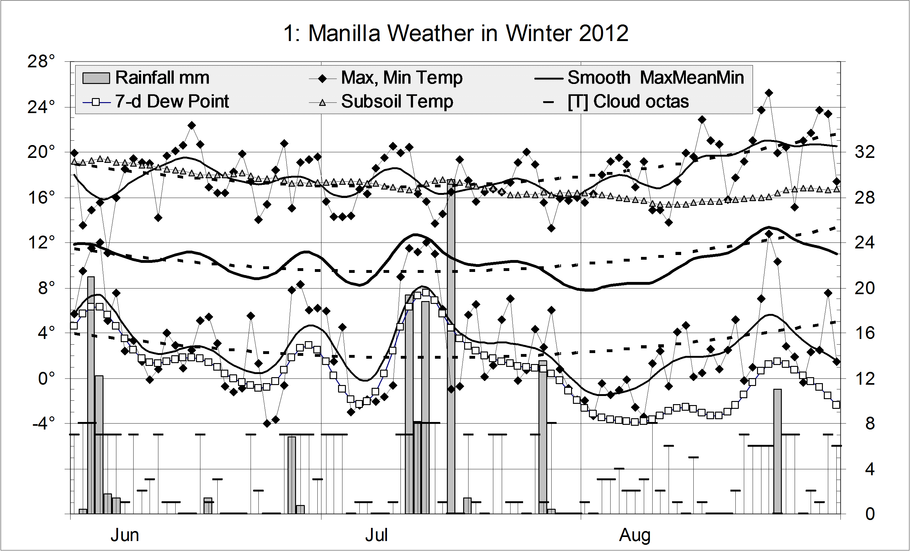
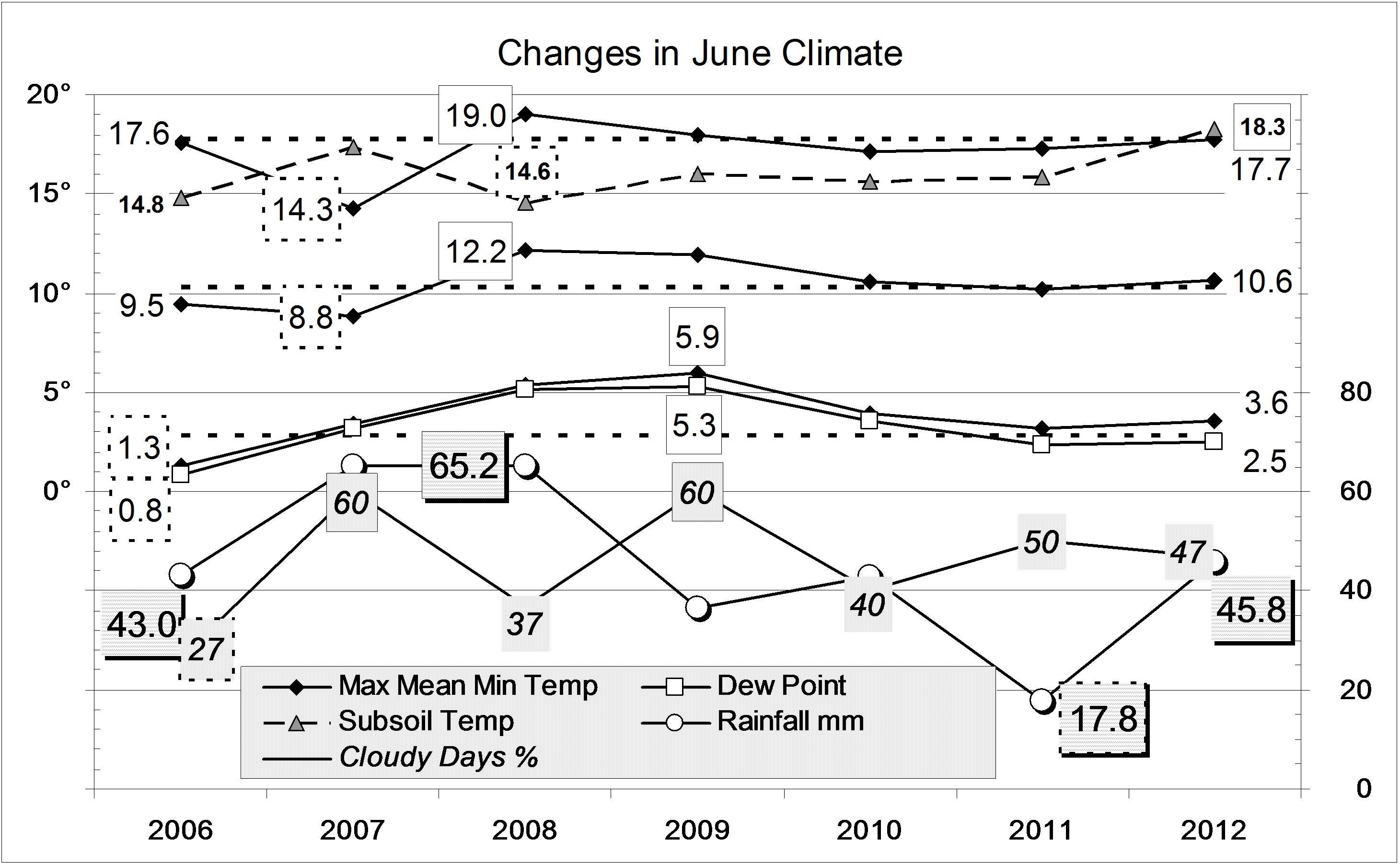
There were two spells of cloudy very wet weather with warm nights, one in the first week of June and one in the second week of July. By contrast, the first week of August was sunny, but with cool days and very cold nights.

Early valley fogs were common in June and July. The total number of frosts (45) was normal, as was the number of severe frosts below minus two degrees (8).
Like last winter, this winter had normal air temperature. Unlike last winter, rainfall was not low, nor the skies extremely cloudy.
Humidity, however, was even lower, marked by a mean early-morning Dew Point of 0.7° (2.2° lower than normal), a new winter record for dry air.
Subsoil temperature was a new winter record high value: 17.1°.
There were 16 rain days, which is just below normal. The winter total of 148.2 mm is in the 66th percentile.Climate winter 2012

Data. Rainfall data is from Manilla Post Office, courtesy of Phil Pinch. Temperatures, including subsoil at 750 mm, and other data are from 3 Monash Street, Manilla.

3-year trends to June 2012

Parametric plots of smoothed climate variables at ManillaTrends to June 2012.

June 2012 anomalies show a return to normalcy for rainfall and maximum temperature. Three moisture-related measures returned to the values of last winter: rather high cloudiness, rather low daily temperature range, and (strangely) rather low Dew Point. Daily min temp returned to the high positive anomaly last seen in 2010.
The subsoil became extraordinarily warm. (Why?)

Fully-smoothed data (in red) show that the 13-year record high monthly rainfall anomaly of November 2011 (+43.8 mm) was not beaten in December, as had seemed likely. The smoothed maximum temperature of December 2011 equalled the record cool anomaly of -1.96 degrees set in October 2010.

Note: Fully smoothed data – Gaussian smoothing with half-width 6 months – are plotted in red, partly smoothed data uncoloured, and raw data for the last data point in orange. January data points are marked by squares. Blue diamonds and the dashed blue rectangle show the extreme values in the fully smoothed data record since September 1999.

Normal Weather in June 2012

The daily weather logWeather log June 2012.

Most weather features in June were normal.: much the same as last year and the year before. Even the frosts were normal. Eleven mornings were frosty, 7 below zero, and 2 below minus 2° (averages: 13, 8, and 2). The coldest morning, Sunday the 24th, was -4.0°. There were several early fogs in the valley but only that on the 24th stayed after 9am.
There were 8 rain days, the highest reading being 21.0 mm on the 3rd.

 Comparing June monthsClimate June 2012.

There is only one variable that is not on the June average: the subsoil temperature at 750 mm is extraordinarily warm, at 18.3°, 3.0° above normal.

The rainfall total of 45.8 mm is within 2 mm of the average (44.3 mm) and in the 60th percentile. Among totals for more than one month, only the 2-, 3-, and 4-month totals are below the median.


Data. Rainfall data is from Manilla Post Office, courtesy of Phil Pinch. Temperatures, including subsoil at 750 mm, and other data are from 3 Monash Street, Manilla.


In 2012, Autumn Weather Normal Again

Weather log autumn 2012.
After the cold, wet summer, autumn weather was normal, like last year. Days were warm in early April, and nights cold in mid-May. Rain was rather light: the four days with more than 10 mm of rain came in late April.
Average air temperatures were close to normal, but the early morning Dew Point was 2.1 degrees down, showing very dry air, as in autumn 2008. The subsoil was very warm.
While the percentage of mornings with more than 4/8 cloud (39%) was lower than in the last two autumns, it is still nearly twice that of autumns in the previous decade, which averaged just 25%.
Rain fell on 16 days (normally 12), but the total rainfall of 87.4 mm is only on the 35th percentile for autumn. Like autumns in 2009 and 2010, it is about 45 mm below the average (133 mm). Nevertheless, an enormous amount of rain fell in spring, summer, and autumn taken together: 852 mm! Only 1956 and 1890 had more rain in those three seasons: 1012 mm and 939 mm.Climate autumn 2012

Data. Rainfall data is from Manilla Post Office, courtesy of Phil Pinch. Temperatures, including subsoil at 750 mm, and other data are from 3 Monash Street, Manilla.

Autumn 2011 Normal but Cloudy


Weather log autumn 2011
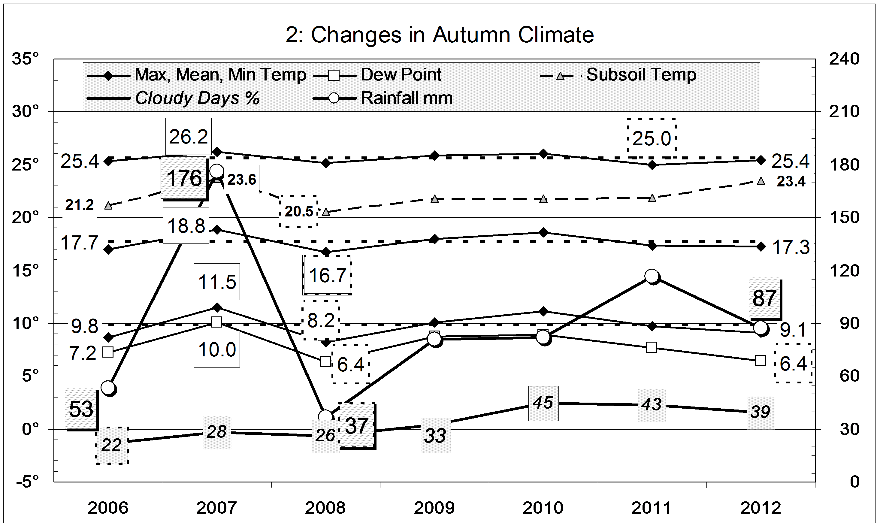
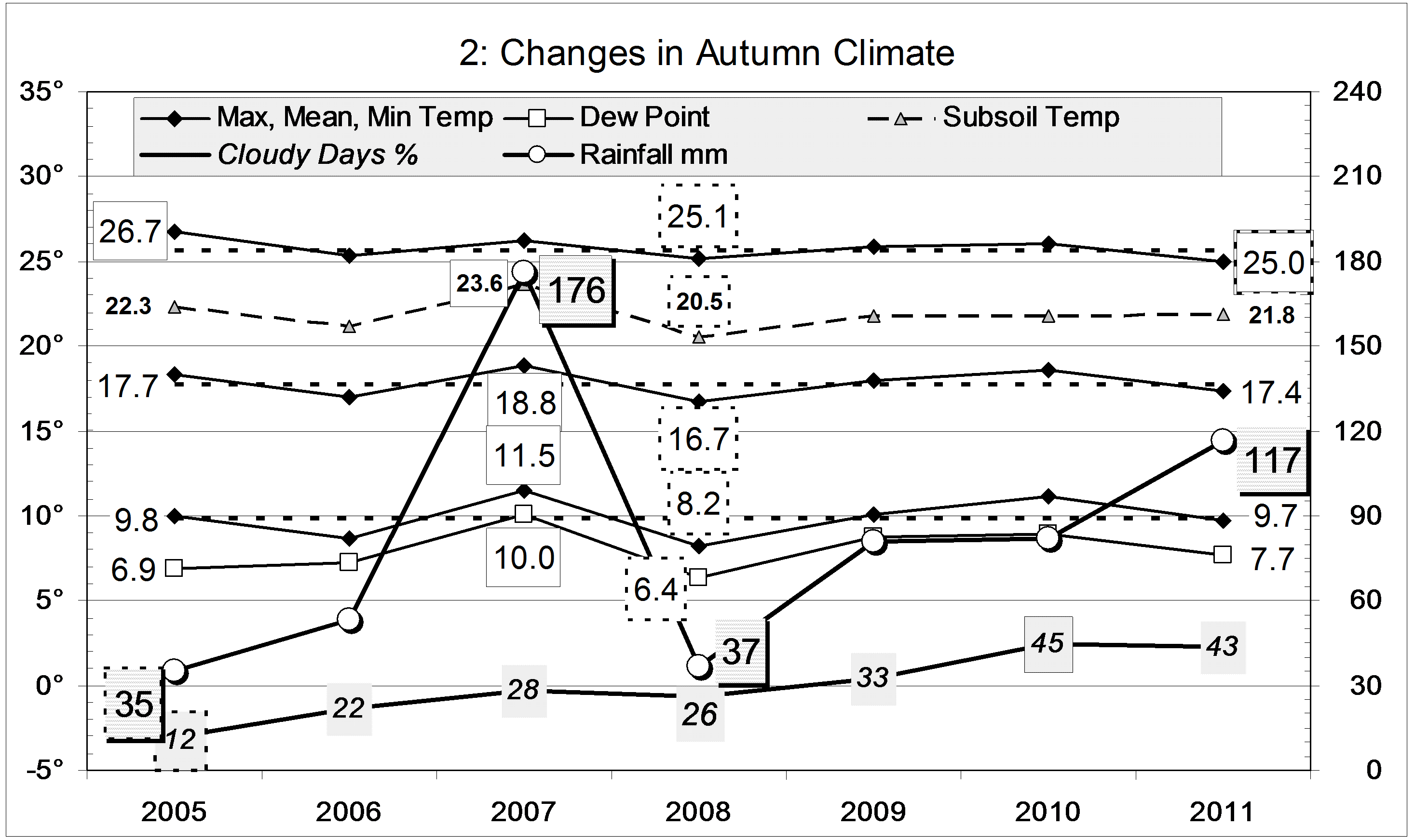
Normal autumn weather was broken by an almost rainless period from mid-April to late May. Temperatures fell very low, particularly at night. The minimum of minus 2.8 degrees on 15/5/11 was a record for autumn. The coldest nights were exceptionally dry: 17/5/11 had the lowest Dew Point in thirteen years, -9.3°. Even during the extreme drought of July 2002, with four Dew Point readings below -6°, the air did not get nearly so dry.

On the average (as shown below) temperatures and the Dew Point were near normal, except that days were rather cool, as in autumn 2008. On average, that autumn, however, was much drier, with cold nights. Autumn 2007 had been very warm and wet.
This time, the percentage of mornings with more than 4/8 cloud was 43%. That almost matches last autumn’s 45% and is far above those of autumns in the previous decade, which averaged just 25%.
Rain fell on 21 days, an unusually large number. The total rainfall of 116.8 mm is on the 52nd percentile for autumn. It is 16 mm below the autumn average (133 mm).Climate autumn 2011

Data. Rainfall data is from Manilla Post Office, courtesy of Phil Pinch. Temperatures, including subsoil at 750 mm, and other data are from 3 Monash Street, Manilla.