March 2012 a bit dry and cool

The daily weather logWeather log March 2012

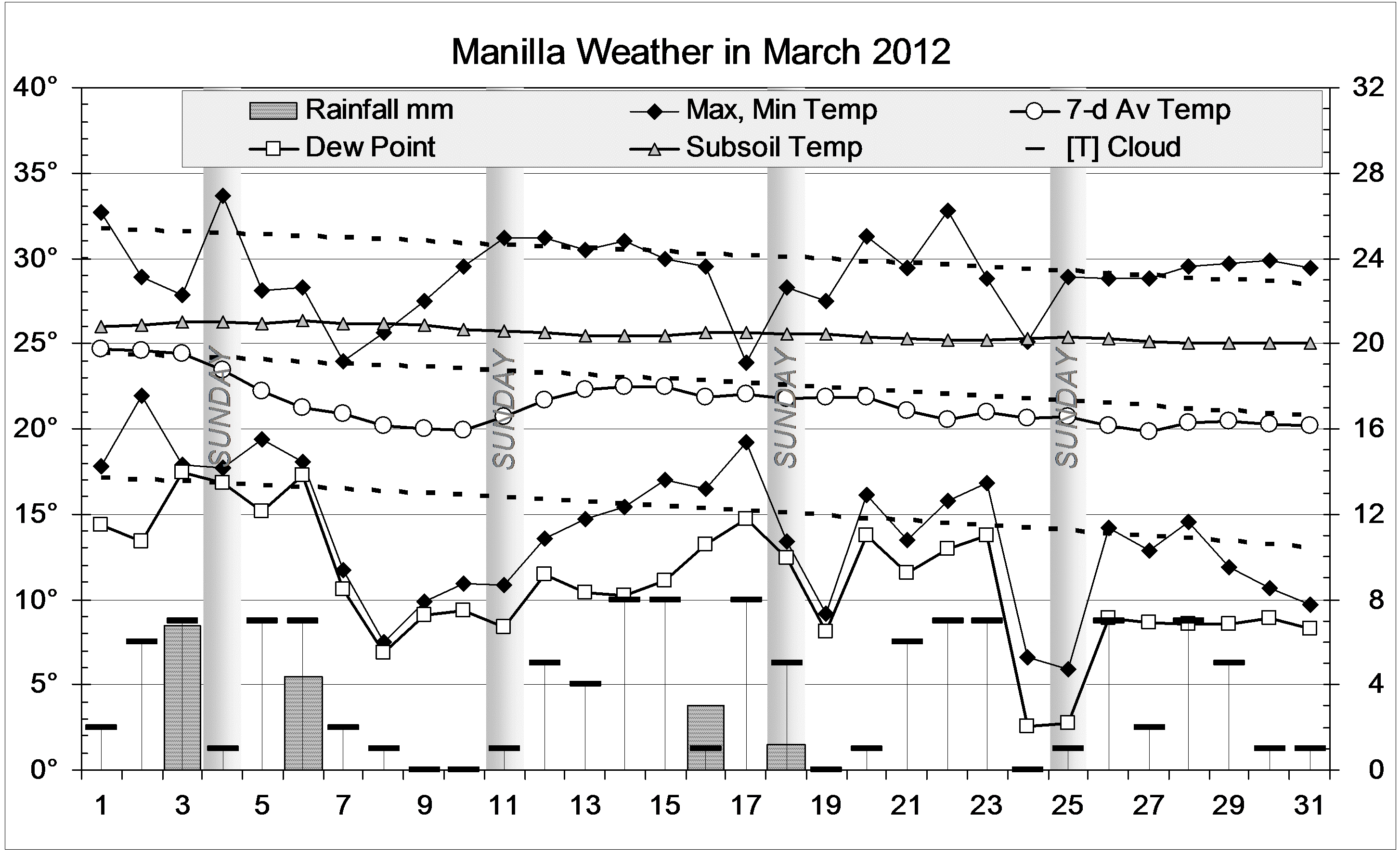
Apart from a cold snap about the 9th, March was just a little cooler than usual. There were four rain days, with a maximum reading less than 7 mm. Late in the month, the weather was showery, but none of that rain fell here.

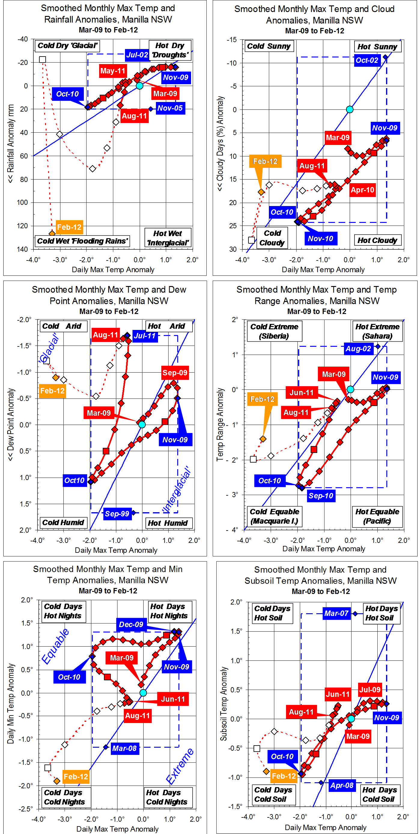
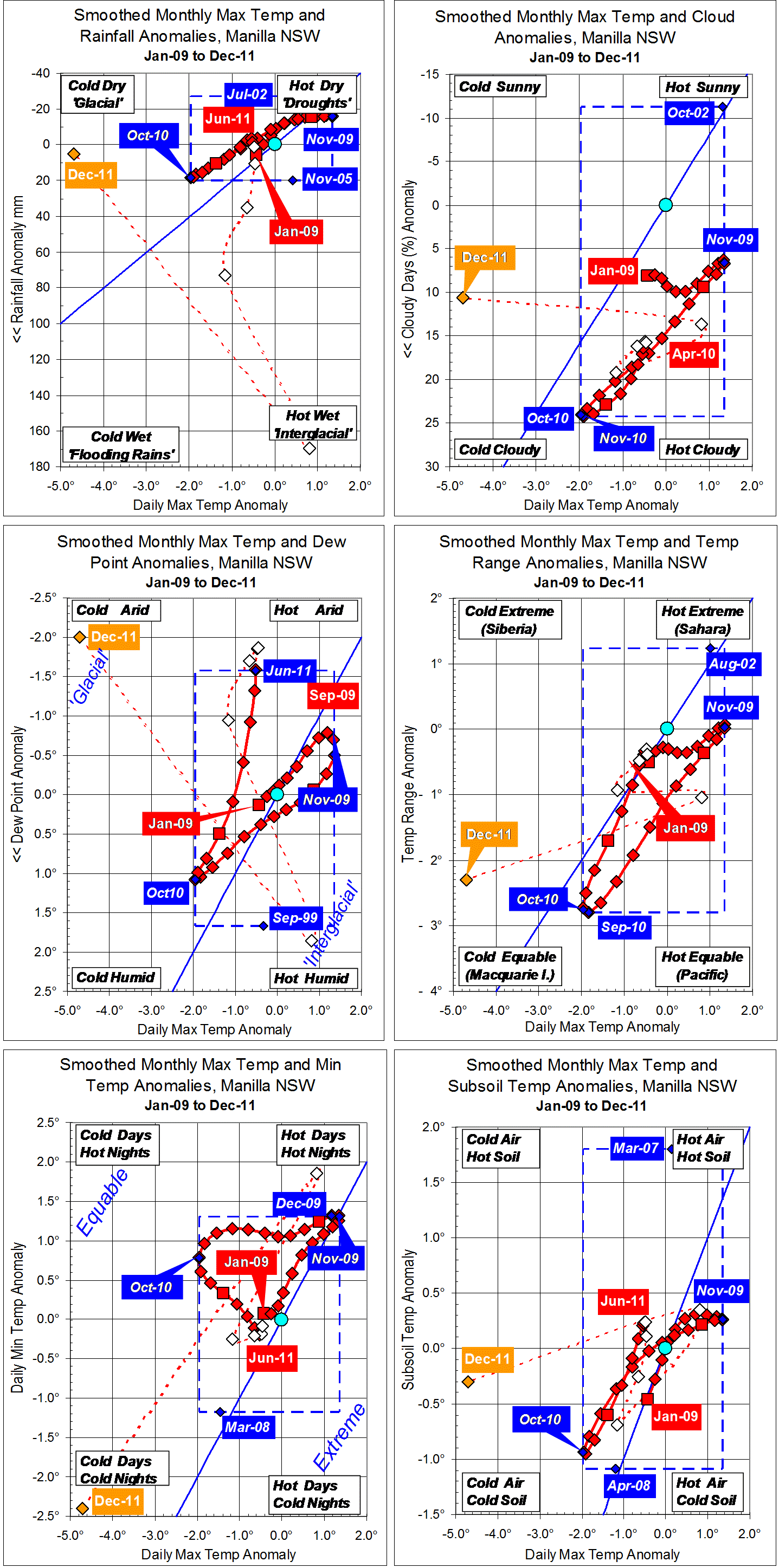
 Comparing March monthsClimate March 2012.

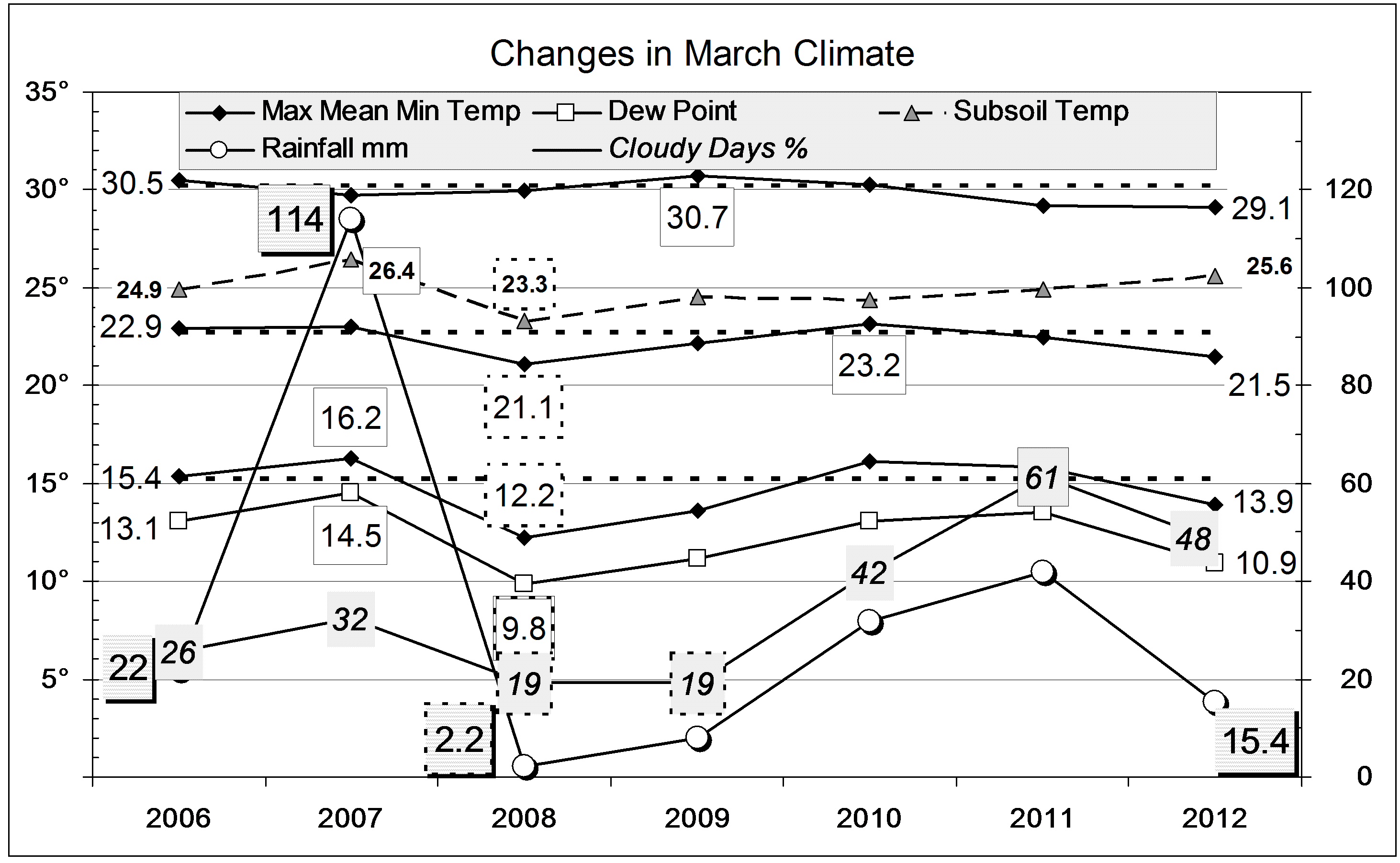
All the mean temperatures, and the Dew Point, were about a degree low. However, this month was not nearly as cold or as dry as March 2008, which had only 2.2 mm of rain, and barely escaped a frost.
The month was very cloudy, but not as cloudy as last year. The subsoil was very warm.
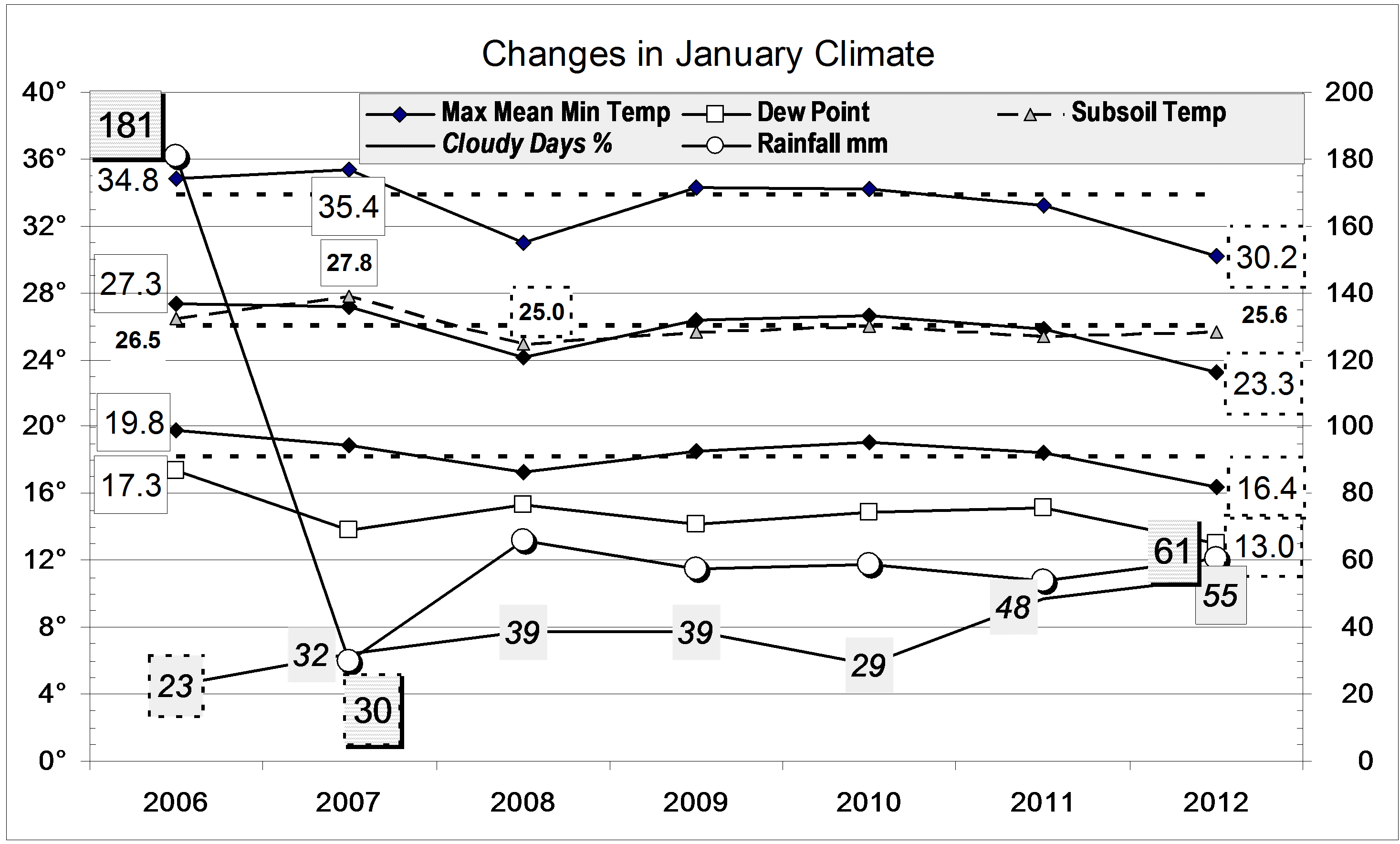
The rainfall total of 15.4 mm is well below the March average of 53.3 mm. It is in the 26th percentile: about one quarter of all March months have been drier than this one. This rather low reading hardly affects the high totals for groups of months. Totals for periods from five months to twenty-four months are still near record high values. No totals up to the thirty-year total are below normal.


Data. Rainfall data is from Manilla Post Office, courtesy of Phil Pinch. Temperatures, including subsoil at 750 mm, and other data are from 3 Monash Street, Manilla.


3-year trends to February 2012

Parametric plots of smoothed climate variables at Manilla

“February 2012 very cold and wet”Trends to February 2012.

Recent partly-smoothed data points generally diverge rapidly from the near-neutral values of winter. February raw anomalies include extremely high rainfall and extremely low daily maximum and minimum temperatures.
Low humidity persists, marked by negative Dew Point anomalies, despite extreme rainfall and cloud cover.

Winter 2011 a time of trend reversal

Fully smoothed data points are now available for Winter 2011. Most variables show stable near-zero anomaly values at a time of trend reversal:
Max temp anomaly (x-axes, all graphs) had been rising since cold October 2010, but peaked in June 2011 while still negative.
Rainfall anomaly, which had reached a minimum just below zero in May, rose quite rapidly during the winter.
Cloudiness varied little around a minimum in July.
Uniquely, Dew Points were very low: the anomaly reached a new record low smoothed value of -1.70 degrees in July. This beat the drought year smoothed value of -1.48 degrees of September and October 2002.
Daily temperature range was slightly low and falling; so was daily minimum temperature. Subsoil temperature was slightly high and falling.

Note: Fully smoothed data – Gaussian smoothing with half-width 6 months – are plotted in red, partly smoothed data uncoloured, and raw data for the last data point in orange. January data points are marked by squares. Blue diamonds and the dashed blue rectangle show the extreme values in the fully smoothed data record since September 1999.

3-year trends to January 2012.

Parametric plots of smoothed climate variables at Manilla

“Low Dew Points and cold days persist”Trends to January 2012.

Except for humid November 2011, Dew Points at Manilla (Centre left graph) have now shown remarkable aridity for nine months. The July 2011 value for Dew Point anomaly, now fully smoothed, requires the blue line to be moved yet again. It sets a new lower limit for smoothed Dew Point anomaly: minus 1.70 degrees.
Daily maximum temperature (X-axis, all graphs), from a remarkably low value (-4.7) in December, rose only to -3.6 in January.
On the top left graph, the rainfall anomaly returned from a record positive value in November to stongly negative within two months.
Cloudiness went from very high to extreme.
Daily temperature range (centre right graph) and daily minimum temperature (bottom left graph) moved back from the extreme values of December.

Note: Fully smoothed data – Gaussian smoothing with half-width 6 months – are plotted in red, partly smoothed data uncoloured, and raw data for the last data point in orange. January data points are marked by squares. Blue diamonds and the dashed blue rectangle show the extreme values in the fully smoothed data record since September 1999.

Cool, very cloudy January 2012

The daily weather logWeather log January 2012.

As in December, nearly all the days and nights of January were cooler than normal. Normally, about twelve days are warmer than 35°, but this time only three were. Sunday the 15th reached only 23°, which is 11° below normal. There were eleven rain days, but the highest rainfall reading, on the 25th, was only 11.2 mm.
The month ended with eleven cloudy mornings in a row. Seven mornings in the month were overcast.

Comparing January monthsClimate January 2012.

All mean temperatures and the Dew Point were lower than in other Januaries shown on the second graph. They were also the lowest on the 13-year record, except that January 2000 had a lower mean minimum of 15.5° and Dew Point of 12.4°. This month’s mean maximum was 3.7° below normal. This extremely low value does not match December’s, which was 4.6° below normal.
Subsoil temperature was not low, but normal. This made the subsoil more than 2° warmer than the air, which is unusual in January.
Fifty-five percent cloudy mornings is a new record for January, and twice as cloudy as usual. Due to that, the mean daily temperature range (13.8°) is near the January record narrow value: 13.7° in 2008.
The rainfall of 60.7 mm is in the 40th percentile for January, well below the long-term average of 86.7 mm. Due to the November deluge, rain totals for groups of months from 3 months up to 24 months remain very high indeed: above the 80th percentile.


Data. Rainfall data is from Manilla Post Office, courtesy of Phil Pinch. Temperatures, including subsoil at 750 mm, and other data are from 3 Monash Street, Manilla.

3-year trends to December 2011

Parametric plots of smoothed climate variables at Manilla

“Extreme changes”Trends to December 2011.

Raw values for some anomalies leap from one extreme to another from November to December 2011. Daily maximum temperature (X-axis, all graphs), from a very high value in November, went to such a remarkably low value (-4.7°) that the scale had to be extended by two degrees.
On the top left graph, the rainfall anomaly returned from an extreme positive value to near zero. Taking max temp and rainfall together, November values were part-way towards the climate of an interglacial epoch, while December values were part-way towards that of a glacial epoch. The centre left graph, including Dew Point anomaly, shows the same effect: hot humid (interglacial) jumping to cold arid (glacial).
While daily temperature range (centre right graph) changed little, daily minimum temperature (bottom left graph) moved with maximum temperature from an extreme of hot days and hot nights to a greater extreme of cold days and cold nights. The November and December values mentioned are far beyond the normal limits (dashed blue lines) set by smoothed data points since 1999.

The last fully-smoothed value (June 2011, in red) for Dew Point anomaly  requires the blue line to be moved. It sets a new lower limit for smoothed Dew Point anomaly: -1.58°. Next month may see the July 2011 value set a new record.
Except for humid November 2011, Dew Points at Manilla have now shown remarkable aridity for eight months.

Note: Fully smoothed data – Gaussian smoothing with half-width 6 months – are plotted in red, partly smoothed data uncoloured, and raw data for the last data point in orange. January data points are marked by squares. Blue diamonds and the dashed blue rectangle show the extreme values in the fully smoothed data record since September 1999.