April 2010 rather warm and dry

The daily weather logWeather log April 2010

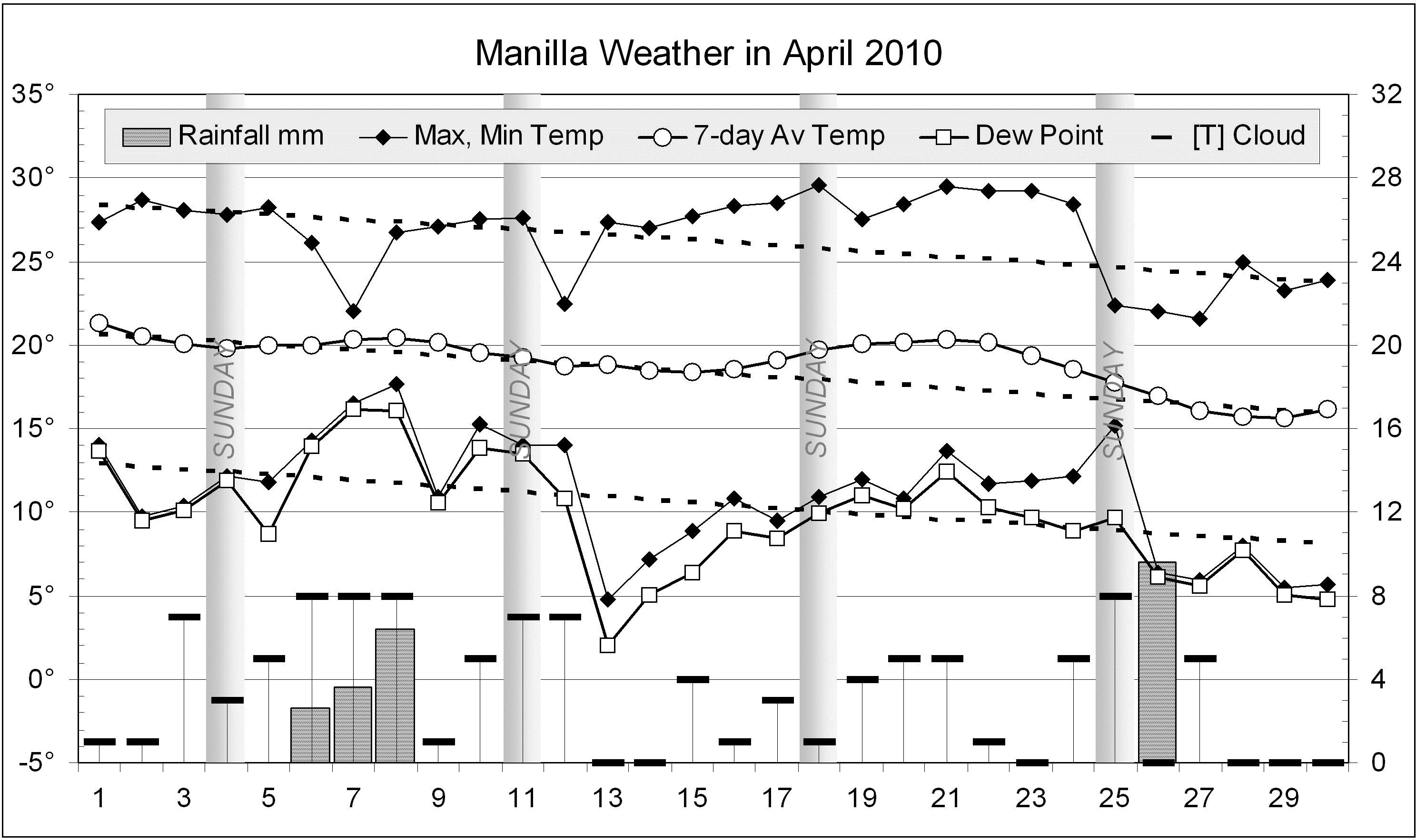
Although the month began with normal temperatures and some rain, the third week became warm, and gardens dried out. On the 26th 9.6 mm of rain was recorded, bringing the monthly total to 22.2 mm in four rain days (the usual number). The month ended sunny with nights that were cooler, but far from frosty.

 Comparing April monthsClimate April 2010

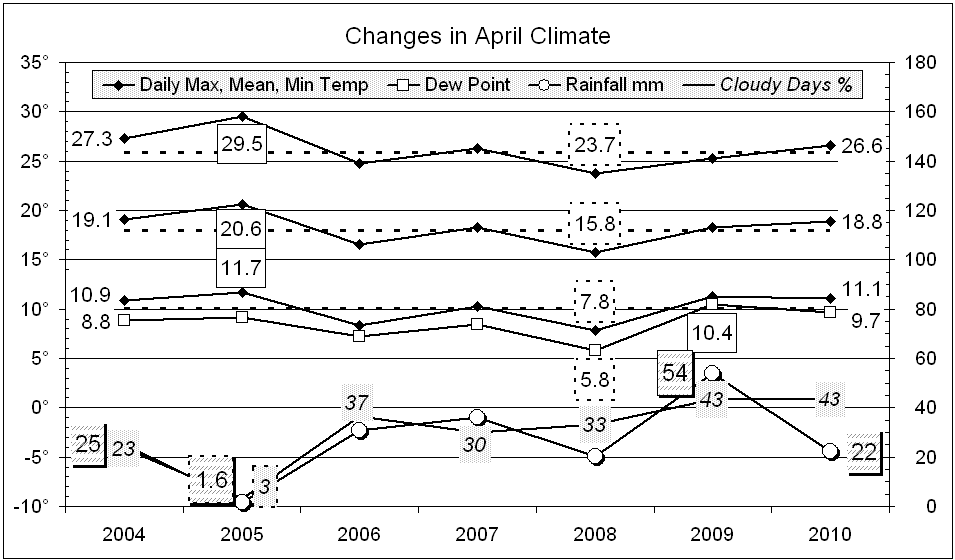
This April was rather warm and dry, but not nearly as warm and dry as April 2005. That month was three degrees warmer than normal and had only 1.6 mm of rain! It had just one cloudy morning, compared to thirteen this month.

The rainfall of 22.2 mm is in the 36th percentile for April, below the long-term average of 38 mm. Rainfall totals for groups of months have fallen, but there are still no serious shortages.. The 12-month total (448 mm) is now down to the 11th percentile: just above the “serious” level.


Data. Rainfall data is from Manilla Post Office, courtesy of Phil Pinch. Temperature and other data are from 3 Monash Street, Manilla.


Parched December 2009 went soggy

The daily weather log

Weather log December 2009

December began dry, very warm, and almost cloudless. In all, there were fourteen days over 35°: remarkable except that it had happened in November too! Plants began dying from lack of rain and low humidity. By the 19th there had been 39 days without 5 mm of rain. The Dew Point on the 12th (-1.1°) was the lowest for a December morning.
Within a week, the sky became overcast, the days cool, and the humidity extreme: the Dew Point from the 27th on was near or above 20°. The hills were often hidden in cloud or rain. The highest rainfall reading (44.6 mm) is a total of several rain days. Heavy rain fell during Sunday the 27th.

 Comparing December months

Climate December 2009

The mean maximum temperature (33.1°) is not as high as in December 2005 (33.7°), but the mean mean (25.9°) and mean minimum (18.6°) are the highest for the decade. All are two degrees warmer than normal, but not extreme as in November.
At 52% cloudy mornings this month was very cloudy, but not as cloudy as December 2007 (58%). The mean morning Dew Point, 12.6°, was normal.
The rainfall total of 75.6 mm is in the 55th percentile, just above the median for December. Most totals for more than one month are quite good. Shortages affect the 6-, 9-, and 12-month totals, but even the 9-month total (now 334 mm) is no longer a serious shortage: it is in the 13th percentile. A shortage in the 10-year rainfall total (15th percentile) may be keeping river base-flows and deep water tables down.

The year 2009

The year 2009 was dry, with only 495 mm of rain. That is on the 16th percentile, meaning one year in six has been drier. It followed two wet years, 2007 with 741 mm (68th percentile) and 2008 with 720 mm (64th percentile).


Data. Rainfall data is from Manilla Post Office, courtesy of Phil Pinch. Temperature and other data are from 3 Monash Street, Manilla.


Spring 2009 warm and dry

Weather log spring 2009

This spring was warm and dry, partly due to the extreme heat wave in the final two weeks. In that period, records were broken for the highest temperature in any month: highest daily maximum (42.6°), highest daily maximum temperature anomaly (+13.5°), highest daily minimum (27.8°), and highest weekly average (31.3°).


Compared to decade averages, the mean maximum (28.4°) was up 2.1° and the mean minimum (11.7°) up 1.3°. For dryness, the morning Dew Point (6.0°) was down 1.5°, and cloudiness (29%) down 1%. Although this spring was very warm and dry, spring 2002 had been much warmer and drier. Values then were: max 29.2°, min 12.1°, Dew Point 5.4° and cloudiness 19%.
In spring 2002 there had been only 66 mm of rain: the fifth lowest on record. Rainfall this spring was 121 mm. Similar spring totals were seen in 2007 (122 mm), 2006 (139 mm), and 2003 (125 mm). These values are on the 30th percentile (which is not very low), but seem low compared to recent extremely wet springs in 2008 (295 mm), 2005 (260 mm) and 1999 (262 mm). The long-term spring median is 156 mm.

Climate spring 2009

Data. Rainfall data is from Manilla Post Office, courtesy of Phil Pinch. Temperatures, including subsoil at 750 mm, and other data are from 3 Monash Street, Manilla.

October 2009 began cool and dry

The daily weather log

Weather log October 2009

The first two weeks of October were cool – as cool as September, and no warmer than late August. There was little rain, low humidity and strong winds. The sub-soil temperature (at 750 mm) also remained low, not reaching 18° until the 18th, two weeks later than usual. Some cotton plantings suffered.
A warm spell came on the 20th, with the maximum on the 23rd (35.4°) being 8° above normal. By contrast, a rainy day on the 26th reached only 18.1°, more than 9° below normal. That day was the first in 33 days to have more than 5 mm of rain. Ten rain days (usually 7) brought 47.4 mm for the month.
Seven days began with a brown dust haze, adding to one in July, three in August, and seven in September.

 Comparing October months

Climate October 2009

Mean temperatures were close to normal. The mean humidity (early morning Dew Point: 4.3°) was low: lower than in 2007, but higher than in 2002 (3.3°). The percentage of cloudy mornings was normal.
The rainfall total, 47 mm, is in the 39th percentile for October, just 6 mm below the median (53 mm). Despite early worries, most rainfall totals improved. The only serious shortage affects the 6-month total. At 164 mm, it is in the 7th percentile.
Totals for periods longer than nine months are normal: the lowest is the ten-year total, which is in the 21st percentile. From November 1999 Manilla has had 6133 mm of rain, against the median 6393 mm. That is a shortfall of only 26 mm per year.


Data. Rainfall data is from Manilla Post Office, courtesy of Phil Pinch. Temperature and other data are from 3 Monash Street, Manilla.


Winter 2009 was very warm and dry

Weather log winter 2009

Daily maximum temperatures were mainly above normal throughout the season, except in the second week of June and in mid-July. The values of 31.8° and 30.5° on the 23rd and 24th of August were the hottest winter days in this 11-year record. Many such records were set at that time in Central Australia, southern Queensland and northern NSW. Similarly, daily minimum temperatures were mainly above normal, except in early August. The night-time minimum of 18.2° on 25/8/09 was 2° warmer than the warmest previous winter minimum of 30/8/04.
Early morning Dew Points remained a degree or two below the daily minimum temperature through June and July. In August, they remained low while the temperature soared, so that the air became uncomfortably dry.
There were 20 rain days (usually 18). Most rain came early in the season, with the maximum daily reading only 13.2 mm.
Cloudy mornings declined sharply during the season: June had 60%, July 45%, and August only 29%


Of the last eleven winters, this was the warmest. The daily mean temperature, 11.8°, was 1.2° above normal. The daily minimum, 4.5°, was also the warmest, but the daily maximum, 19.1°, did not reach the 19.2° of winter 2002.

This winter was one of the least frosty, with 39 frosts rather than the usual 44. There was only one reading below minus two, while other winters had from three to nineteen! The mean Dew Point of 1.7° was normal for winter.
The rainfall total of 65 mm is well below average for winter (125 mm). It is in the 13th percentile, much wetter than winter 2002 which, at 45 mm, was in the 7th percentile.
This was the second cloudiest winter of the decade. Forty-six percent of the mornings had more than 4/8 cloud. Last winter was a little cloudier, at 48%.

Climate winter 2009

Data. Rainfall data is from Manilla Post Office, courtesy of Phil Pinch. Dew Point values before August 2005 are from Tamworth Airport 6am data supplied by the Bureau of Meteorology. Temperature and other data are from 3 Monash Street, Manilla.