December 2014 rainy with warm nights

Photo of a rain-shower

A shower on Mt Baldwin

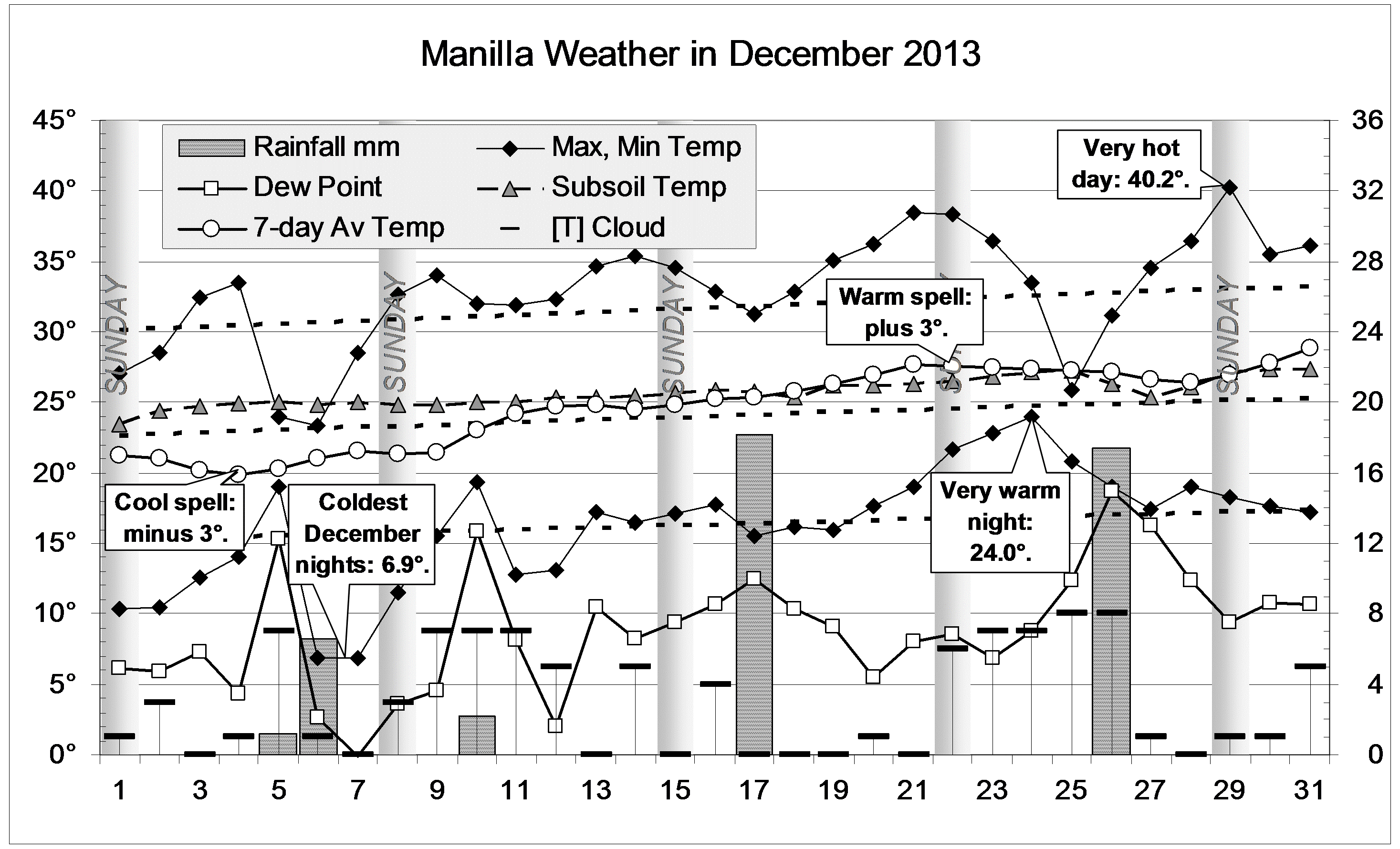
Few days or nights were unusually warm or cool, except for a very cold day on the 28th. Thunderstorm clouds were often seen, but only a few yielded any rain. Later, overcast skies brought steady rain recorded on the 27th (25.2 mm) , 28th (11.2 mm) and 29th (12.6 mm). There were fourteen rain days: twice the usual number.

Weather log December 2014

Comparing December months

The mean daily maximum temperature (31.8°) was normal, but the mean daily minimum temperature (18.0°) was very high (Very warm nights!), just below the record of 18.6° set in 2009.
Subsoil temperature (24.7°) fell to normal after two Decembers above normal.
The total rainfall of 99.0 mm was in the 72nd percentile, well above the average of 74 mm. This clears most of the shortages in rainfall totals for groups of months. Two serious shortages remain: the nine month total of 306 mm is in the 8th percentile, and the eighteen month total of 659 mm is in the 6th percentile.

Climate for December 2014

The Year 2014

This year had the warmest nights (11.34°) of the new century. Although the days, at 26.67°, were cooler than in 2002 (26.72°), this year had also the warmest mean temperature: 19.01°. The second-warmest, at 18.85°, was 2009 and the coolest, at 17.19°, was 2008.
The subsoil temperature: 20.5°, fell back to near average.
In the year, 39% of the mornings were cloudy (more than four octas of cloud). This is close to the recent average (40%) for 2007 to 2014, but much more cloudy than the earlier average (26%) for 2000 to 2006.
The rainfall, 447 mm, was second lowest in the new century, after 2002 (366 mm). In the long-term rainfall record, this is a serious, but not severe deficiency: it is in the 8th percentile.


Data. Rainfall data is from Manilla Post Office, courtesy of Phil Pinch. Temperatures, including subsoil at 750 mm, and other data are from 3 Monash  Street, Manilla.

3-year trends to December 2014

Parametric plots of smoothed climate variables at Manilla
“December 2014 rain again”

Trends to December 2014

December data (orange)

From November to December, the raw anomaly value for daily maximum temperature returned to normal from extremely high. Rainfall anomaly moved from very dry to rather wet. Most other anomalies came back to near zero, where they had been (as smoothed values) in June 2014, six months earlier.
Temperature range became low while daily minimum temperature remained high. (Which causes which?)

Fully smoothed data (red)

The latest fully-smoothed data (June 2014) mainly show a renewed movement towards drought.


Note:

Fully smoothed data – Gaussian smoothing with half-width 6 months – are plotted in red, partly smoothed data uncoloured, and raw data for the last data point in orange. January data points are marked by squares.
Blue diamonds and the dashed blue rectangle show the extreme values in the fully smoothed data record since September 1999.

Normal values are based on averages for the decade from March 1999.* They appear on these graphs as a turquoise (turquoise) circle at the origin (0,0). A range of anomalies called “normal” is shown by a dashed rectangle in aqua (aqua). For values in degrees, the assigned normal range is +/-0.7°; for cloudiness, +/-7%; for monthly rainfall, +/-14 mm.

 * Normal values for rainfall are based on averages for the 125 years beginning 1883.

December Climate Anomalies Log

Heat indicators log for December

This post is the tenth in a set for the 12 calendar months that began with March. Graphs are sixteen-year logs of the monthly mean anomaly values of nine climate variables for Manilla, NSW, with fitted trend lines. I have explained the method in notes at the foot of the page.

Raw anomaly values for December

Extreme values of December anomalies were as follows:

Daily Maximum Temperature Anomalies (2) -3.6 deg:
December 2010; -4.7 deg: December 2011;
Rainfall Anomalies (1) +80 mm: December 2004;
Minus (Temperature Range Anomaly) (1) +3.7 deg: December
2010;
Dew Point Anomalies (1) -4.4 deg: December 2013.

Trend lines for December

Heat Indicators

All heat indicator quartic trends began low and ended high, and had a peak in 2003 or 2004 and a trough in 2010. The range from peak to trough was greatest for maximum anomalies and least for minimum and subsoil anomalies.

Moisture indicators log for December

Continue reading

December 2013: air still dry

The daily weather logWeather log December 2013.

The month began cool, including two nights at 6.9°, the coldest December nights in this record. Later it became very warm, with one night of 24.0° and one day of 40.2°. Spells of sunny weather were separated by five rainy days.
The relative humidity on the afternoon of the 29th was the record low value of 4%, as on 10/1/13 and 13/8/13. (These values may be wrong. Few hygrometers can be read so low.)

Comparing December monthsClimate December 2013

This December was warm: just slightly cooler than December last year, and very much warmer than those of 2010 and 2011. Extremely dry air brought a new record low December mean morning dew point of 8.8°.
Subsoil temperature (25.7°) remained 1.5° above normal.
The total rainfall of 45.6 mm was in the 28th percentile, well below the average of 74 mm. However, there are still no serious shortages in rainfall totals for more than one month.

The Year 2013

This was one of the warmer years in the new century (but much cooler than 2009). It had the driest air, with a mean early morning dew point of 5.4°, 1.5° below average. The air has become drier each year since 2010.

This year also had the highest subsoil temperature: 22.1°, 1.9° above average.
Extremely high rainfall in June (98mm) was balanced by very low rainfall in August (6.4mm) and October (15mm), for a low annual total of 576 mm, in the 37th percentile.


Data. Rainfall data is from Manilla Post Office, courtesy of Phil Pinch. Temperatures, including subsoil at 750 mm, and other data are from 3 Monash Street, Manilla.

3-year trends to December 2012

Parametric plots of smoothed climate variables at Manilla

“Retreat from drought”Trends to December 2012.

In December, the anomaly of daily maximum temperature retreated from the November extreme of +3 degrees to +1.5 degrees. Dew Point and daily temperature range also retreated from drought values. Cloudiness remained normal and daily minimum temperature high. Subsoil temperature returned to the very high values of the winter months.
The variables maximum temperature, minimum temperature, and temperature range are now close to the smoothed values they had three years ago, in December 2009.

Fully-smoothed data (in red) for June 2012 have reached new records for low Dew Point anomaly (-2.61 degrees) and for high subsoil temperature anomaly (+1.99 degrees).

Note: Fully smoothed data – Gaussian smoothing with half-width 6 months – are plotted in red, partly smoothed data uncoloured, and raw data for the last data point in orange. January data points are marked by squares. Blue diamonds and the dashed blue rectangle show the extreme values in the fully smoothed data record since September 1999.