Warm Nights in Summer 2009-10


Weather log summer 2009-10

No warm spell this summer matched that of late November, which had four days over 40°. There was only one 40° day all summer. By February there were no warm spells.
Summer began hot and very dry, with clear skies and low humidity. Year’s end saw days of rain, low cloud and extremely high humidity. In mid-January the air was again very dry, but cool.


The mean daily maximum temperature was normal, but the mean minimum (18.7°) was the highest in eleven summers. The number of nights warmer than 20° (34) is also the highest, nearly twice the usual number.
The total rainfall of 190 mm is below the long-term summer average of 225 mm. It is in the 42nd percentile.
At 42% cloudy mornings, this summer was very cloudy, but not extremely cloudy like the summer of 2007-08 (53%). These summers shared the record for completely overcast mornings, with 18 each.

Climate for summer 2009-10


Data. Rainfall data is from Manilla Post Office, courtesy of Phil Pinch. Temperatures, including subsoil at 750 mm, and other data are from 3 Monash Street, Manilla.

June 2009 cloudy, with warm nights

The daily weather log

Weather log June 2009

Cloudy skies kept most June nights warm. A cold snap took the minimum on the 12th down to -3.2°. As in June 2005, there were only 5 frosts, compared with 13 normally. Few days were very warm or cool, but the 11th reached only 12.1° (6° below normal). There was patchy fog in the valley on three mornings.
Ten rain days brought 36.4 mm. The wettest was the 22nd, with 13.2 mm.

 Comparing June months

Climate June 2009

This June was very cloudy: 60% of the mornings had more than 4 octas of cloud. June 2005 (53%) and June 2007 (60%) were similar. The 11-year trend shows a big rise in June cloudy mornings: from 6 in 1999 to 16 in 2009!

The mean daily maximum temperature was normal for June. However, the mean daily minimum (5.9°) was the highest for the decade, beating other Junes that had warm nights: 2005 (5.7°) and 2008 (5.4°). The month’s mean temperature was high (like last June) and the temperature range low (12.1°). The mean humidity (early morning dew point) was also high.
The rainfall total of 36 mm is on the median (50th percentile) for June. Rainfall totals for groups of months up to six months are below the median, indicating shortages. However, even the worst is not serious: the four-month rainfall March to June (117 mm) is on the 14th percentile. Rainfall totals for longer periods up to 72 months are all above the median, except for the 36-month total, which is on the 49th percentile.


Data. Rainfall data is from Manilla Post Office, courtesy of Phil Pinch. Dew point values before August 2005 are from Tamworth Airport 6 am data supplied by the Bureau of Meteorology. Temperature and other data are from 3 Monash Street, Manilla.


Cloudy Autumn 2009

Weather log autumn 2009

Temperatures cooled as normal in autumn, with few unusual features. Through early March and early May nights were cold, humidities were low, and skies were clear. Later in May, nights were very warm.
There were 16 rain days, which is more than normal (12), but most had very low readings. One rain day in April (36 mm) brought nearly half the season’s rain.


As in the summer, all mean temperatures (daily maximum, mean, and minimum), as well as the morning Dew Point, were normal. Neither of the previous two autumns had been normal: autumn 2008 was very cool and arid; autumn 2007 was very warm and humid.
The total rainfall of 81 mm is on the 30th percentile for autumn. It is 32 mm below the autumn median rainfall (113 mm).
At 33% cloudy mornings, this autumn was the cloudiest of the decade. Autumns average only 25% cloudy mornings, compared to 31% in winter and 30% in spring and in summer.

Climate autumn 2009

Data. Rainfall data is from Manilla Post Office, courtesy of Phil Pinch. Dew Point values before August 2005 are from Tamworth Airport 6am data supplied by the Bureau of Meteorology. Temperature and other data are from 3 Monash Street, Manilla.

May 2009 rain by-passed Manilla

The daily weather log

Weather log May 2009

More than half the month passed with sunny days, and cool nights (3°) that kept the average temperature down. The 18th was the 34th day without 5 mm of rain.
A lot of rain then came into the region carried on easterly winds from the very warm sea. The coast had five days of heavy rain, causing severe flooding. Manilla had only three rain days, totalling less than 16 mm. At the same time, areas near Mungindi had twice as much. Instead of rain, Manilla got a week of humid overcast days and very warm nights (11°). Thick fog on the 29th did not lift until after 10 am.

 Comparing May months

Climate May 2009

This month had normal temperatures, but it was cloudier than any May since 2001. There were seven mild frosts (normally six), but none was below zero in the screen.

(May 2007 was warm and humid; May 2006 was cool and remarkably sunny.)
The rainfall total (19.0 mm) was in the 34th percentile for the month. While this is below the May median (27 mm), it is well above the most common May reading (5 mm). The two-month total for April and May (73 mm) is on the 33rd percentile. The three-month total (81 mm) is worse: it is on the 14th percentile, but that is not a serious shortage. The four and five month rainfall totals have now fallen to 38th and 41st percentiles. Beyond that, totals are above the median for all periods up to 72 months, except for the 15-month total, which has now fallen to the 45th percentile.


Data. Rainfall data is from Manilla Post Office, courtesy of Phil Pinch. Dew point values before August 2005 are from Tamworth Airport 6 am data supplied by the Bureau of Meteorology. Temperature and other data are from 3 Monash Street, Manilla.


Winter came very late in 2008*

Weather log winter 2008

The daily weather log

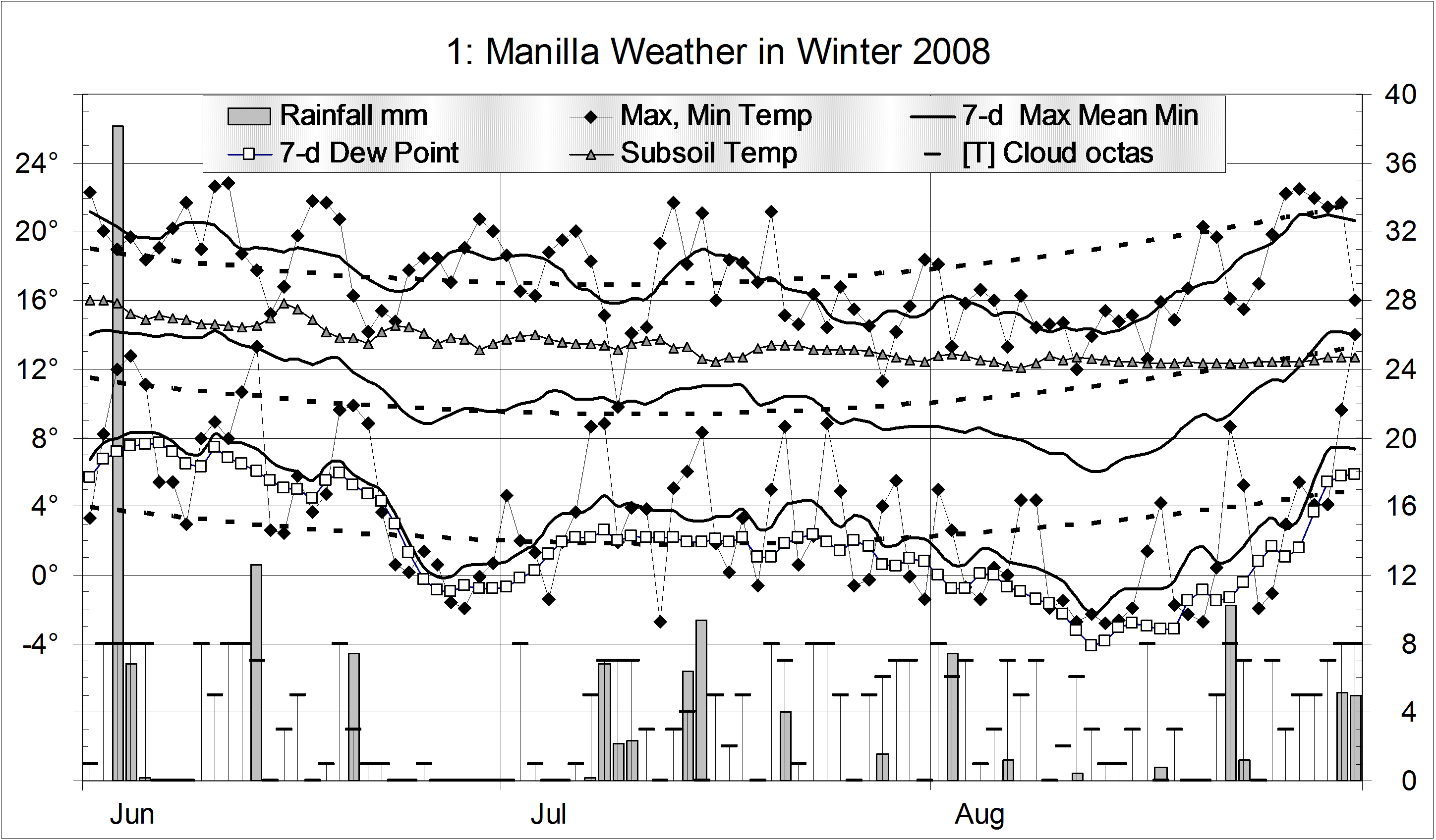
For most of June and July, temperatures were warmer than normal, especially at night. There were a couple of severe frosts in late June, and one in mid-July. The coldest part of winter, however, came extremely late. In the second week of August, both days and nights were six degrees colder than normal. There were more sub-zero nights in August than in June and July together.
Early morning dew points above 7° in early June showed high humidity. Later, dew points below zero showed the air was extremely dry in late June and almost all of August.
The winter was a little less frosty than usual, with 40 frosts rather than the usual 44. There were 24 readings below zero and 7 below minus two, but none below minus four.
There were 21 rain days, totaling 136 mm. Most rain came early in the season. The first rain day, with 38.2 mm, was the wettest winter day in ten years.
July and August were extremely cloudy months, with 52% and 55% cloudy mornings. June, at 37%, was also cloudy.

Comparing winter seasons

Mean daily temperatures (daily maximum, minimum, and mean) were close to normal this winter. Because the maximum was slightly down, and the minimum slightly up, the daily temperature range was reduced. At 14.1°, it was narrower than the normal 15.3° but not extreme like the 13.2° of last winter.
The mean dew point of 1.9° was normal for winter.
The rainfall total of 134 mm is above the long-term average for winter (125 mm). The graph includes the ninth driest winter, 2002. Just ten years ago, 304 mm of rain in the winter of 1998 made it the second wettest on record.
This was the cloudiest winter of the decade. Forty-eight percent of the mornings had more than 4/8 cloud. The winter average is thirty-one percent. The graph suggests a trend to more cloudy winters since 2002.

Climate winter 2008

Data. Rainfall data is from Manilla Post Office, courtesy of Phil Pinch. Dew Point values before August 2005 are from Tamworth Airport 6 am data supplied by the Bureau of Meteorology. Temperatures, including subsoil at 750 mm, and other data are from 3 Monash Street, Manilla.

* The title is a rhyming anapestic tetrameter. With the original “by”-line, it was a rhyming  anapestic hexameter. No-one noticed.