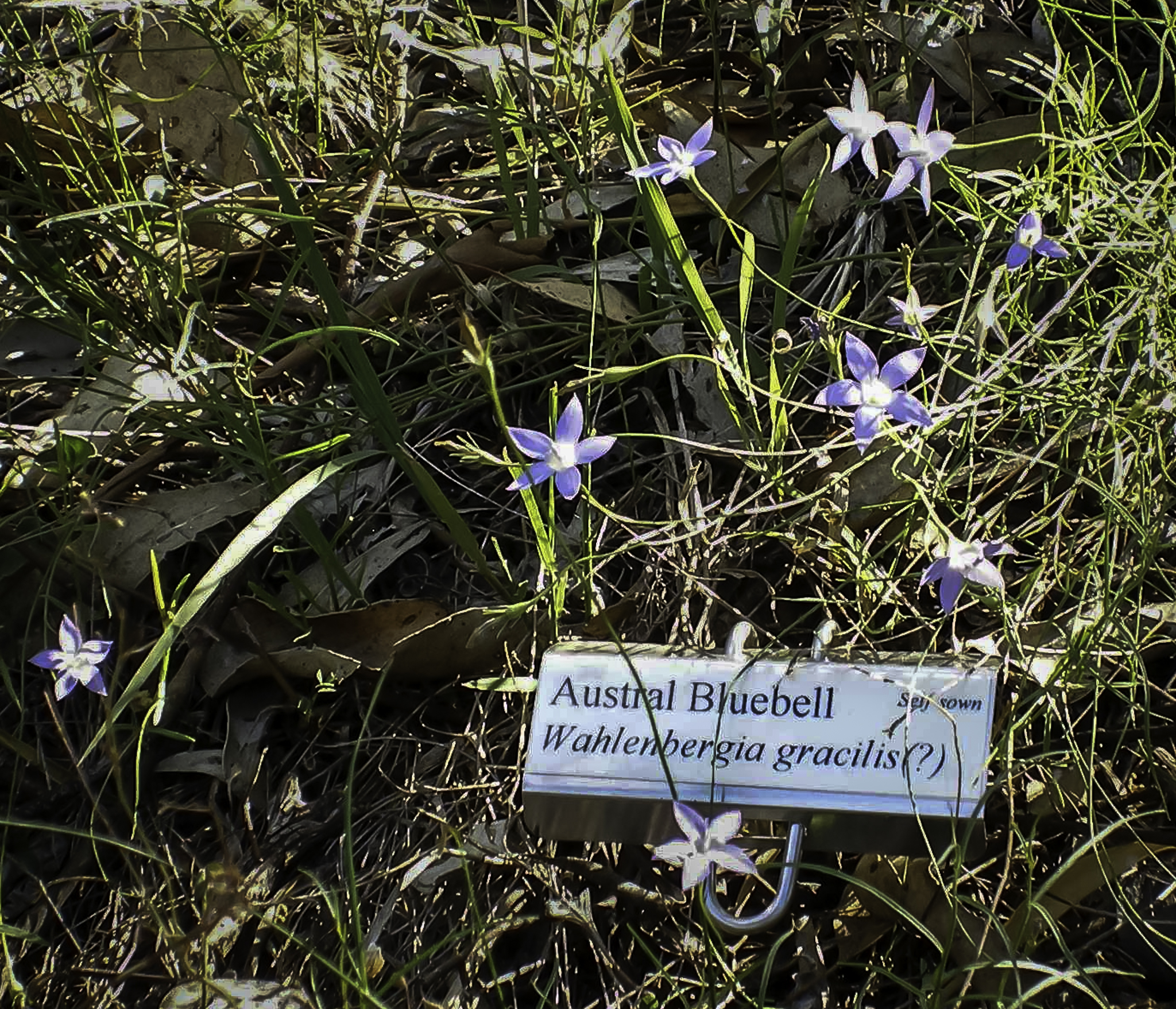
Autumn 2014 cloudy with warm nights

Austral bluebells in autumn

Autumn bluebells

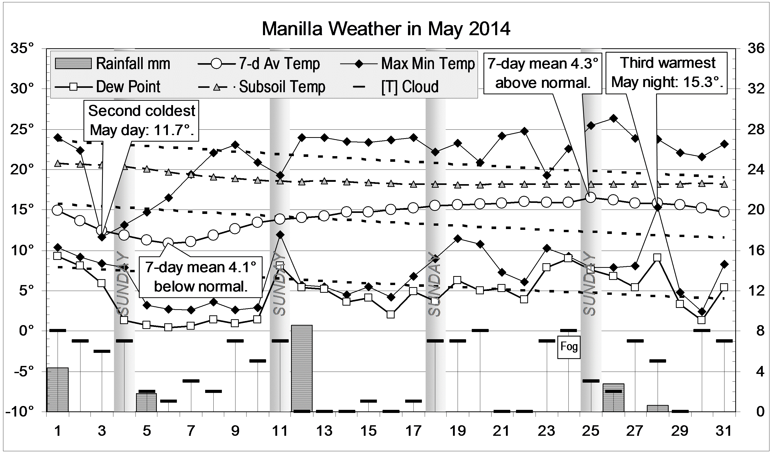
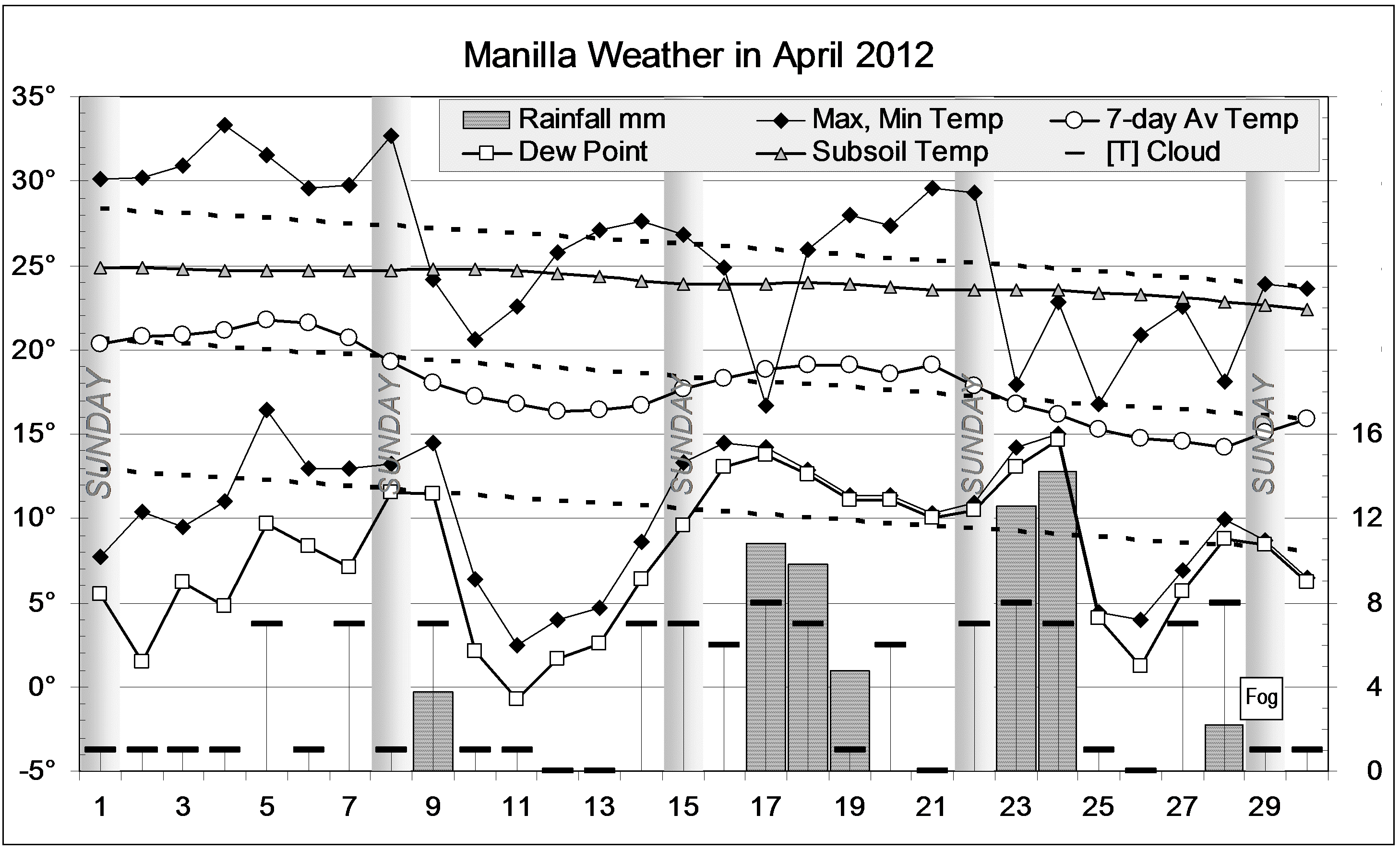
There were two severe cold spells in late March and early May. Days were several degrees colder than normal, and the daily temperature range was narrow. To compensate, there were three spells of very warm nights in early April, late April, and late May. The last of these also had warm days and lasted a fortnight.

Weather log autumn 2014

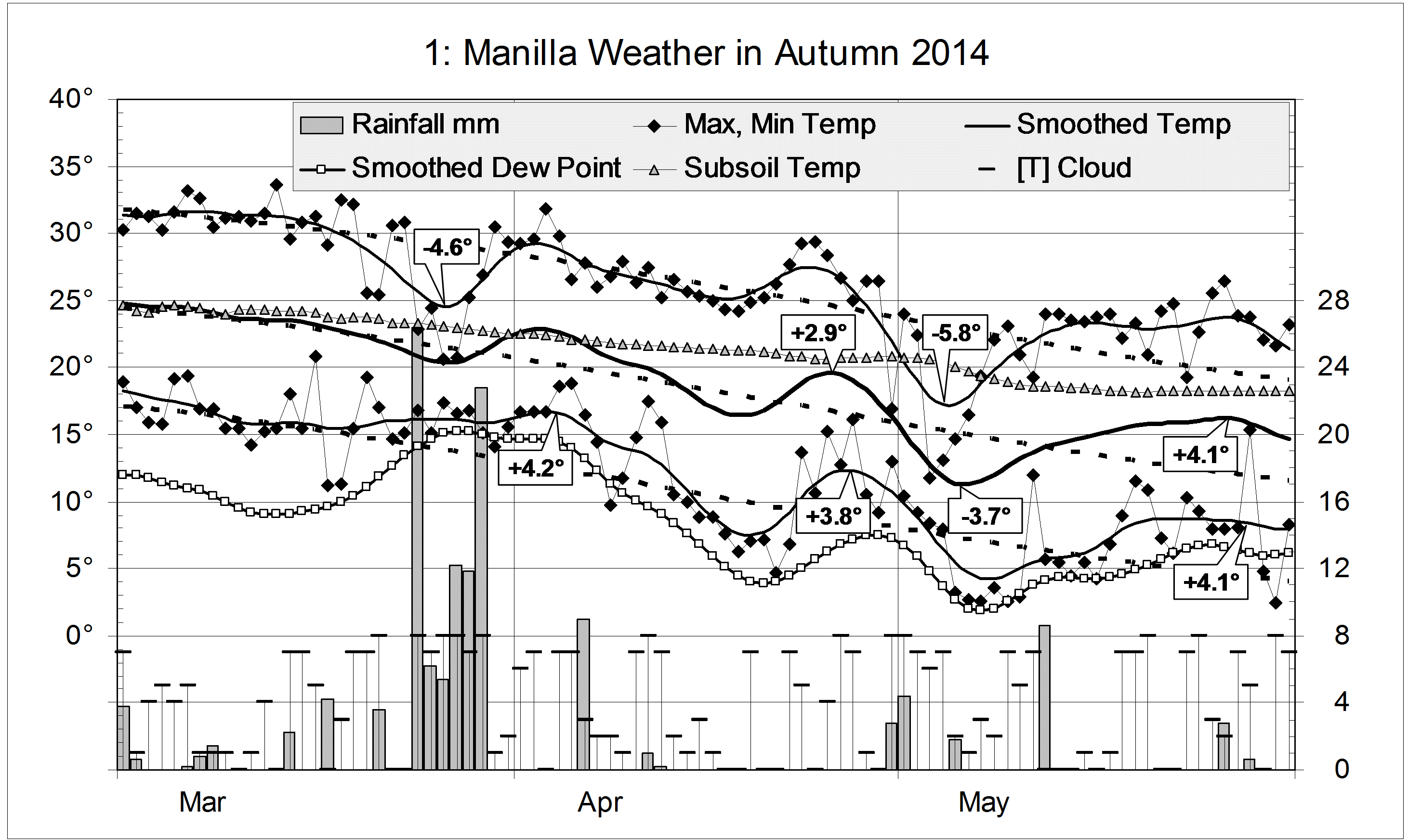
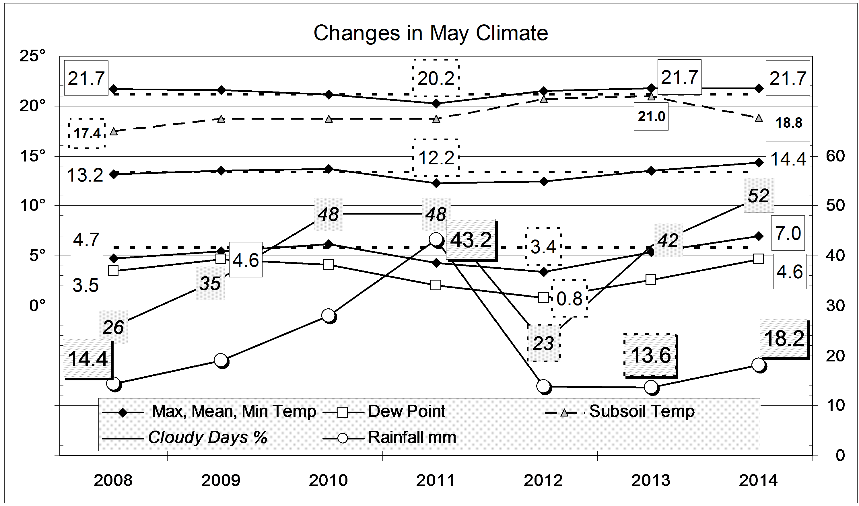
Rain fell on 23 days (twice the normal number), totalling 132.8 mm. Most of it (84.8 mm)  fell in the week beginning on the 24th of March. The autumn total is on the 125-year average, and in the 58th percentile.

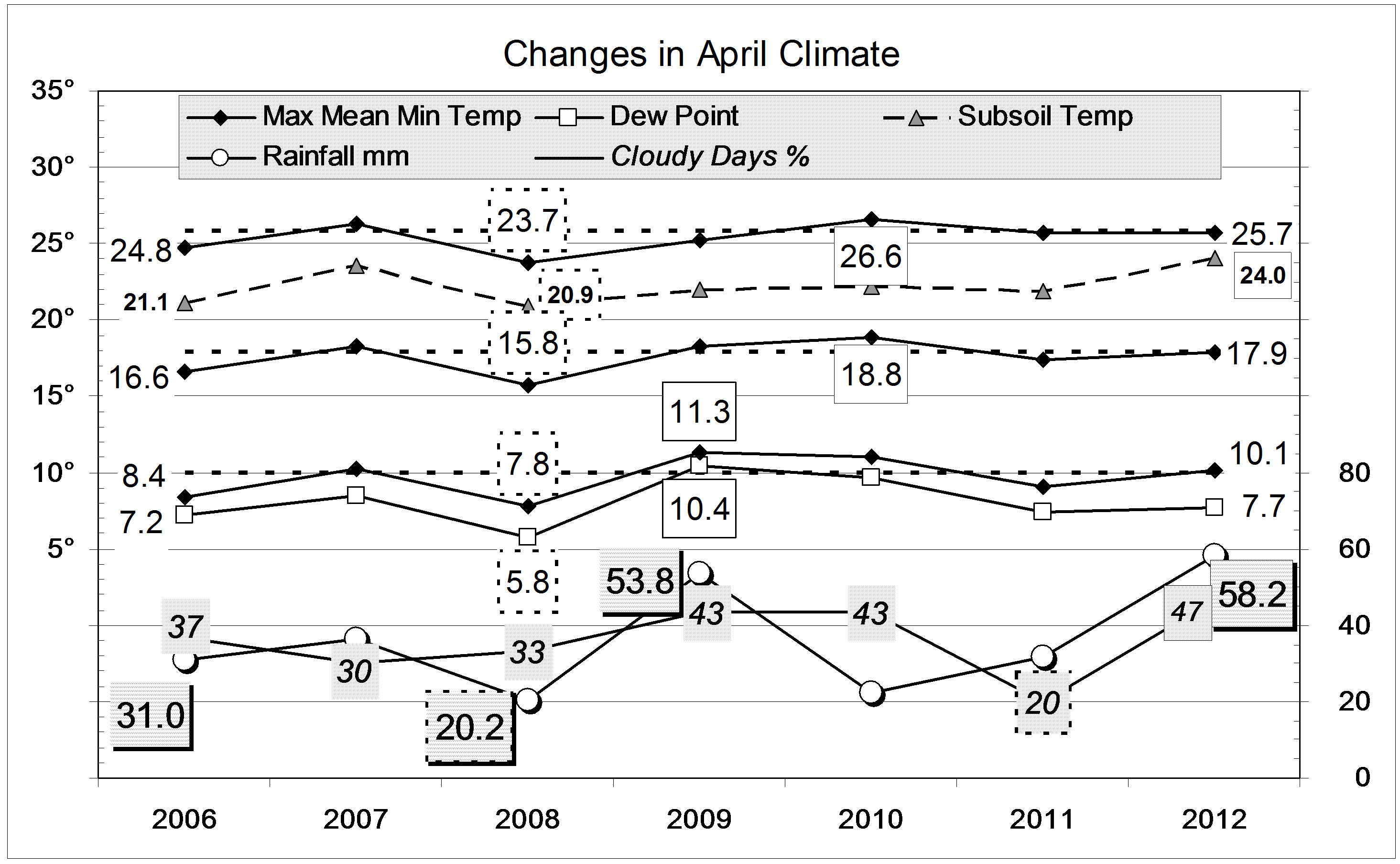
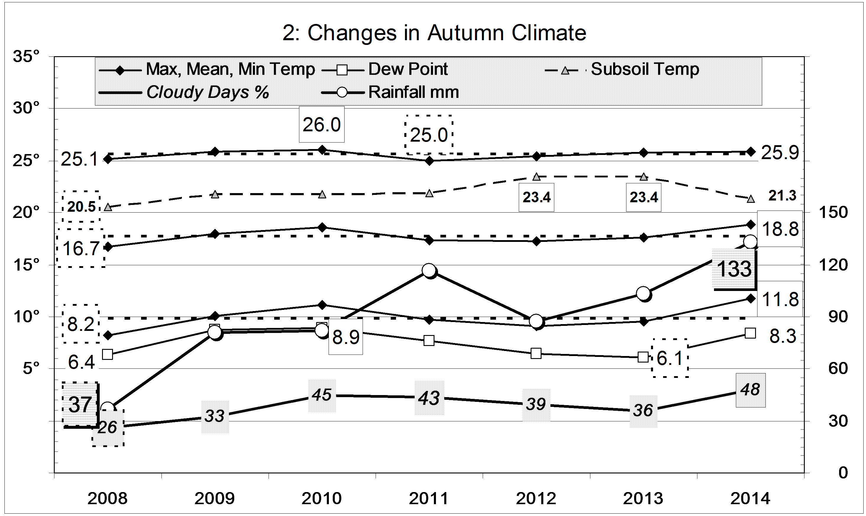
In autumn seasons from 1999, this was equal warmest with 2007, but nights (11.8°) were by far the warmest, 1.3° above normal. The mean daily temperature range, at 14.1°, was the narrowest, and the percentage of cloudy days (48%) the highest. All these point to a more moist (maritime) climate than does the rainfall or the dew point.

Climate for autumn 2014


Data. Rainfall data is from Manilla Post Office, courtesy of Phil Pinch. Temperature, including subsoil at 750 mm, and other data are from 3 Monash Street, Manilla.

May 2014 cloudy with warm nights

The daily weather log

Yellow berries  on a White Cedar in May.

White Cedar in May

May began cold: the 3rd was the 2nd coldest May day of this century, at 11.7°. By the 6th, the 7-day mean temperature was more than four degrees below normal. Within a week, the weather became warm and, by the 25th, the 7-day mean was more than four degrees above normal. The night of the 26th (15.3°) was the 3rd warmest May night of the century. For the first time, May had no frosts at all, and more than half the mornings were cloudy (>4/8 cloud). There were five rain days, two more than usual.

Weather log May 2014

Comparing May months

Air temperatures and the dew point were not far from normal. However, as the second graph shows, they are higher than in May months of recent years, such as 2012. Skies were extraordinarily cloudy, but the subsoil temperature was no longer high.
The total rainfall of 18.2 mm is in the 33rd percentile for May. While this is well below the long-term average of 41 mm, it is on the average for the last 15 years. Taking rainfall totals for more than one month, only the two-month total (31 mm) is a serious shortage (9th percentile). The fifteen-month total (585 mm) is in the 12th percentile. Other totals have higher percentile values, and most totals for 36 months or more are above normal. Pools still survive in Greenhatch Creek.

Climate May 2014


Data. Rainfall data is from Manilla Post Office, courtesy of Phil Pinch. Temperatures, including subsoil at 750 mm, and other data are from 3 Monash Street, Manilla.

June 2013: Extreme Cloud and Rain

The daily weather logWeather log June 2013.

The first weeks were warmer than usual, including a Queen’s Birthday Saturday that reached a pleasant 23°. In contrast, Tuesday the 25th reached only 9.7° making it the fifth coldest day of the century.

There were hardly any sunny mornings in the month, and most were close to overcast. Cloud kept the nights warm, limiting the number of frosts to only eight. The night of the 7th had a minimum of 12.6°, nine degrees above normal.

The wettest of 10 rain days had 38.0 mm, almost as high as a 38.2 mm reading in June 2008.

Comparing June MonthsClimate June 2013.

Extreme cloudiness and rain lead this month’s climate values. Having 73% of mornings with cloud covering more than half the sky makes this the cloudiest month in the 21st century by far. July 2010 and March 2011 reached only 61%. This month’s figure is over twice the June average of 33% cloudy mornings.

With a rainfall total of 98.0 mm, this is the eighth wettest June in 131 years. The wettest was June 1920, with 173 mm. That was the first of a cluster of four extremely wet Junes, ending with June 1931, that were among the ten wettest. Only eight years ago, June 2005 was the sixth wettest on record, at 109 mm.
This month’s rainfall defers any shortage. Among totals for more than one month, the driest is the 34th percentile for the last three months (Total 3-month rain: “only” 116 mm).
The mean daily maximum temperature, 17.3°, is just 0.5° below normal, but the mean daily minimum, 5.7°, is very high, 2.9° above normal (as in 2005, 2008 and 2009). The subsoil remains very warm.


Data. Rainfall data is from Manilla Post Office, courtesy of Phil Pinch. Temperatures, including subsoil at 750 mm, and other data are from 3 Monash Street, Manilla.

April 2012 cloudy and wet

The daily weather logWeather log April 2012.

Most days had normal temperatures, but several were cool and overcast. Cold nights came during sunny spells, the coldest, on the 11th, being nine degrees below normal, but not a frost. Rain totalling 58.2 mm fell on seven rain days, mainly late in the month, with a maximum reading of 14.2 mm on the 24th.

 Comparing April monthsClimate April 2012.

All the mean temperatures were near normal, except that subsoil temperature was the highest for April on this record: 2.1 degrees above normal.

There were more cloudy days than recorded in earlier Aprils.
The rainfall total of 58.2 mm is well above the April average of 39.3 mm: it is in the 80th percentile. The total for March and April taken together (73.6 mm) is exactly on the average. As in March, totals for periods from five months to twenty-four months are still near record high values, and no totals up to the thirty-year total are below normal.


Data. Rainfall data is from Manilla Post Office, courtesy of Phil Pinch. Temperatures, including subsoil at 750 mm, and other data are from 3 Monash Street, Manilla.


Cool, very cloudy January 2012

The daily weather logWeather log January 2012.

As in December, nearly all the days and nights of January were cooler than normal. Normally, about twelve days are warmer than 35°, but this time only three were. Sunday the 15th reached only 23°, which is 11° below normal. There were eleven rain days, but the highest rainfall reading, on the 25th, was only 11.2 mm.
The month ended with eleven cloudy mornings in a row. Seven mornings in the month were overcast.

Comparing January monthsClimate January 2012.

All mean temperatures and the Dew Point were lower than in other Januaries shown on the second graph. They were also the lowest on the 13-year record, except that January 2000 had a lower mean minimum of 15.5° and Dew Point of 12.4°. This month’s mean maximum was 3.7° below normal. This extremely low value does not match December’s, which was 4.6° below normal.
Subsoil temperature was not low, but normal. This made the subsoil more than 2° warmer than the air, which is unusual in January.
Fifty-five percent cloudy mornings is a new record for January, and twice as cloudy as usual. Due to that, the mean daily temperature range (13.8°) is near the January record narrow value: 13.7° in 2008.
The rainfall of 60.7 mm is in the 40th percentile for January, well below the long-term average of 86.7 mm. Due to the November deluge, rain totals for groups of months from 3 months up to 24 months remain very high indeed: above the 80th percentile.


Data. Rainfall data is from Manilla Post Office, courtesy of Phil Pinch. Temperatures, including subsoil at 750 mm, and other data are from 3 Monash Street, Manilla.