3-year trends to February 2018

Warm

3-year trends to February 2018

February raw anomaly data (orange)

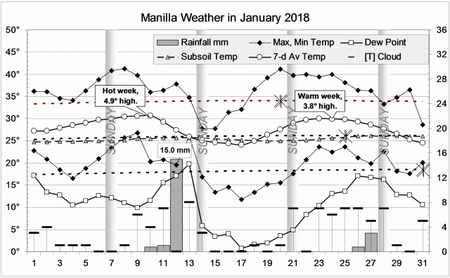
February 2018, unlike January, had days that were not very hot and nights with normal temperature. Rainfall rose to a normal value. Continuing low moisture was shown only by a very low dew point and a wide daily temperature range.

 Fully smoothed data (red)

Data for winter (JJA) 2017

These latest of the fully-smoothed data points showed that last winter was near-normal and changing little in most respects. Both dew point and temperature range were moving up their graphs towards aridity. Daily minimum temperature and subsoil temperature were cooling.

Main patterns of fully-smoothed data

In this period, the only major departure from normal climate was the cool moist winter (JJA) of 2016. Loops in the top four graphs show that more moisture preceded lower temperature. Minima in daily minimum temperature and in subsoil temperature came several months later, at the end of spring.


Note:

Fully smoothed data – Gaussian smoothing with half-width 6 months – are plotted in red, partly smoothed data uncoloured, and raw data for the last data point in orange. January data points are marked by squares.
Blue diamonds and the dashed blue rectangle show the extreme values in the fully smoothed data record since September 1999.

Normal values are based on averages for the decade from March 1999.* They appear on these graphs as a turquoise (turquoise) circle at the origin (0,0). A range of anomalies called “normal” is shown by a dashed rectangle in aqua (aqua). For values in degrees, the assigned normal range is +/-0.7°; for cloudiness, +/-7%; for monthly rainfall, +/-14 mm.

 * Normal values for rainfall are based on averages for the 125 years beginning 1883.

January 2018 hot and dry

Brushtail possum resting

Brushtail Possum

The first heat wave of the month was nearly five degrees above normal: a little worse than last January’s. Rain, mainly on the 12th, brought a cool spell with very dry air. A second heat wave was not so bad, and it was gone by the 31st.
Three days went over 40° (but January 2003 had five) and three nights did not go below 25° (a January record).
Rain fell on five days (usually seven), the highest reading being 15 mm.

Weather log for January 2018

Comparing January months

The average temperature this January (27.9°) was not as high as last January (28.7°), or even January 2013 (28.2°). The days (36.2°) were second hottest after 2017 (36.4°), but the nights (19.7°) were only fourth hottest.
The estimated rainfall of 20.6 mm was low: at the 11th percentile, and only one quarter of the January average (87 mm). However, there are still no serious rainfall shortages. The lowest percentile value (12th percentile) is the five-year total of 2760 mm, which is 440 mm below the normal five-year total of 3200 mm.

Climate in January months


Data. A Bureau of Meteorology automatic rain gauge operates in the museum yard. From 17 March 2017, 9 am daily readings are published as Manilla Museum, Station 55312.  These reports use that rainfall data when it is available, but it is not.  The gauge last reported on 24 September 2017.

All data, including subsoil at 750 mm, are from 3 Monash Street, Manilla.

3-year trends to January 2018

Hot and dry

3-year trends to January 2018

January raw anomaly data (orange)

January 2018, like December, had hot days and hot nights, but had even lower rainfall.

 Fully smoothed data (red)

The latest fully-smoothed data point is for July 2017.
Most variables were normal and static at that time. Dew point was low and falling, while daily temperature range was rather high and rising.


Note:

Fully smoothed data – Gaussian smoothing with half-width 6 months – are plotted in red, partly smoothed data uncoloured, and raw data for the last data point in orange. January data points are marked by squares.
Blue diamonds and the dashed blue rectangle show the extreme values in the fully smoothed data record since September 1999.

Normal values are based on averages for the decade from March 1999.* They appear on these graphs as a turquoise (turquoise) circle at the origin (0,0). A range of anomalies called “normal” is shown by a dashed rectangle in aqua (aqua). For values in degrees, the assigned normal range is +/-0.7°; for cloudiness, +/-7%; for monthly rainfall, +/-14 mm.

 * Normal values for rainfall are based on averages for the 125 years beginning 1883.

December 2017 as in 2016

Blooms of San Pedro Cactus at Manilla NSW

San Pedro Cactus 2017

The weather in this December was very like the weather a year ago. Even details were similar. Each had just one 40° day. Each had one night near 25°, about 9° above normal. This December had one hot spell 6.3° above normal: last December had two hot spells 4.8° and 3.6° above normal. Neither had cool spells.
This December’s highest rainfall reading, 15.5 mm (unofficial), was like last December’s 17.8 mm (also unofficial). This month had fewer rain days (5 vs. 12) and longer dry spells.

Weather log for December 2017

Comparing December months

This was one of the hottest Decembers in the new century. The mean daily maximum, at 33.7°, equals that of December 2005, but is beaten by 33.8° last December. The mean daily minimum, at 18.2°, equals that of last December, but is not as warm as the 18.6° of December 2009. By contrast, December 2011 was the coldest, with a mean maximum of only 27.0°, and a mean minimum of only 13.9°.
This month’s subsoil temperature (23.0°) was very cool; one of four December values more than a degree below normal.
Like last December, this month was not very moist, but not very sunny either.
The rainfall of 48.2 mm was practically the same as in December 2016 and 2013. It is at the 35th percentile: not high, but high enough to prevent shortages.

Climate in December months

The Year 2017 was warm and dry

In this record (2000 to 2017), Manilla’s average annual temperature this year (18.65°) shows it to be the third warmest, after 2014 (19.01°) and 2009 (18.85°). The coolest was 2008 (17.19°), which was also cool globally. (Apart from 2008, Manilla annual temperatures do not follow global temperatures closely: the hottest year globally (2016) was not a very warm year here.)
Like the previous two years, 2017 had night temperatures half a degree below the normal value. Day temperatures, which had been near normal in 2015 and 2016, became a degree warmer. This year’s subsoil temperature (19.80°) was cool, very much cooler than in 2013 (22.19°).

It was a year of very low rainfall: 517 mm, which is at the 20th percentile, and 135 mm below the average (652 mm). Three even lower rainfall totals have occurred in the last sixteen years: 366 mm in 2002 (2nd percentile), 495 mm in 2009 (16th percentile), and 447 mm in 2014 (8th percentile).
Manilla yearly rainfall history: four momentsThis unusually high ratio of very dry years agrees with other patterns seen in Manilla’s annual rainfall. That is, in the moments of the frequency distributions. Recently, Manilla’s annual rainfall has had (i) very high kurtosis, showing increased extremes (“fat tails”), and (ii) negative skewness, showing that these extremes are low extremes, not high extremes.


Data. A Bureau of Meteorology automatic rain gauge operates in the museum yard. From 17 March 2017, 9 am daily readings are published as Manilla Museum, Station 55312.  These reports use that rainfall data when it is available, but it is not.  The gauge last reported on 24 September 2017.

All data, including subsoil at 750 mm, are from 3 Monash Street, Manilla.

3-year trends to December 2017

Hot days and nights

3-year trends to December 2017

December raw anomaly data (orange)

December 2017 had hot days and hot nights, but the subsoil remained cold. Rainfall was low, while other measures of moisture were near normal.

 Fully smoothed data (red)

The latest fully-smoothed data point is for June 2017. By that time, all variables were within the normal range except for dew point. Even dew point was in the centre of the range of low values that has become “normal” since 2010. Three variables were static: daily maximum temperature, subsoil temperature, and rainfall. Cloudiness, dew point, and daily temperature range. were moving towards aridity. Daily minimum temperature was falling.


Note:

Fully smoothed data – Gaussian smoothing with half-width 6 months – are plotted in red, partly smoothed data uncoloured, and raw data for the last data point in orange. January data points are marked by squares.
Blue diamonds and the dashed blue rectangle show the extreme values in the fully smoothed data record since September 1999.

Normal values are based on averages for the decade from March 1999.* They appear on these graphs as a turquoise (turquoise) circle at the origin (0,0). A range of anomalies called “normal” is shown by a dashed rectangle in aqua (aqua). For values in degrees, the assigned normal range is +/-0.7°; for cloudiness, +/-7%; for monthly rainfall, +/-14 mm.

 * Normal values for rainfall are based on averages for the 125 years beginning 1883.