Extremely Dry Air in August 2012

The air in August was drier than in any month on this 14-year record. Relative humidity in the afternoons was only about 25%, well below the usual 37%. The air has been very dry here for more than a year. The record rainfall last spring may have prevented serious bush-fires, but this year could be different.

The daily weather logWeather log August 2012.

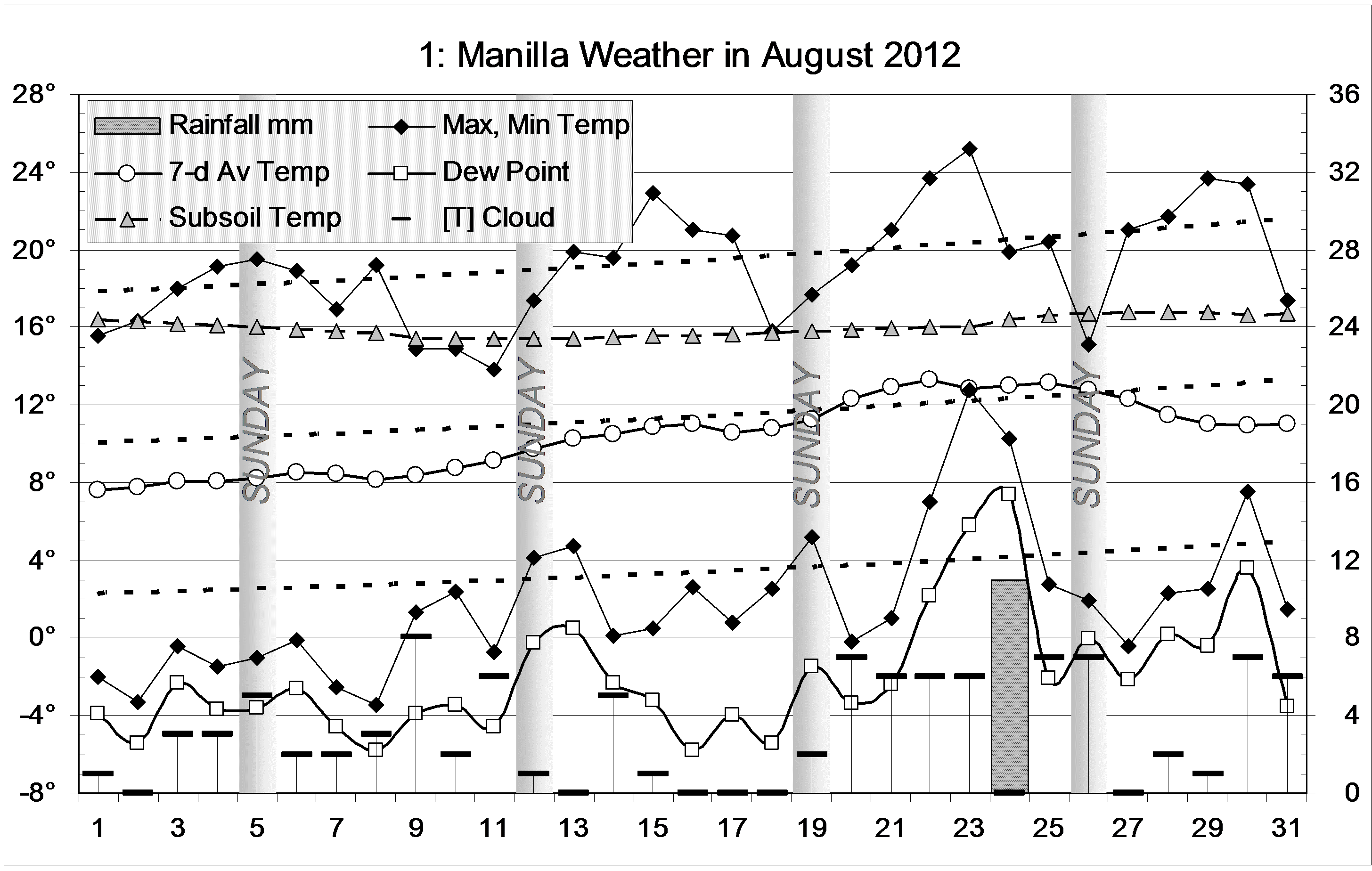
Days were not very warm or cold. Most nights were cold, with 18 frosts (usually 15). Two frosts were severe (below minus 3°), but there was also one night as warm as 12.8°.
Extremely low Dew Points (dry air) of minus 5.8° were recorded on the mornings of the 8th and 16th. Only seven lower values have occurred in 14 years.
The only rainfall (11.0 mm) was recorded on the 24th.

 Comparing August monthsClimate August 2012.

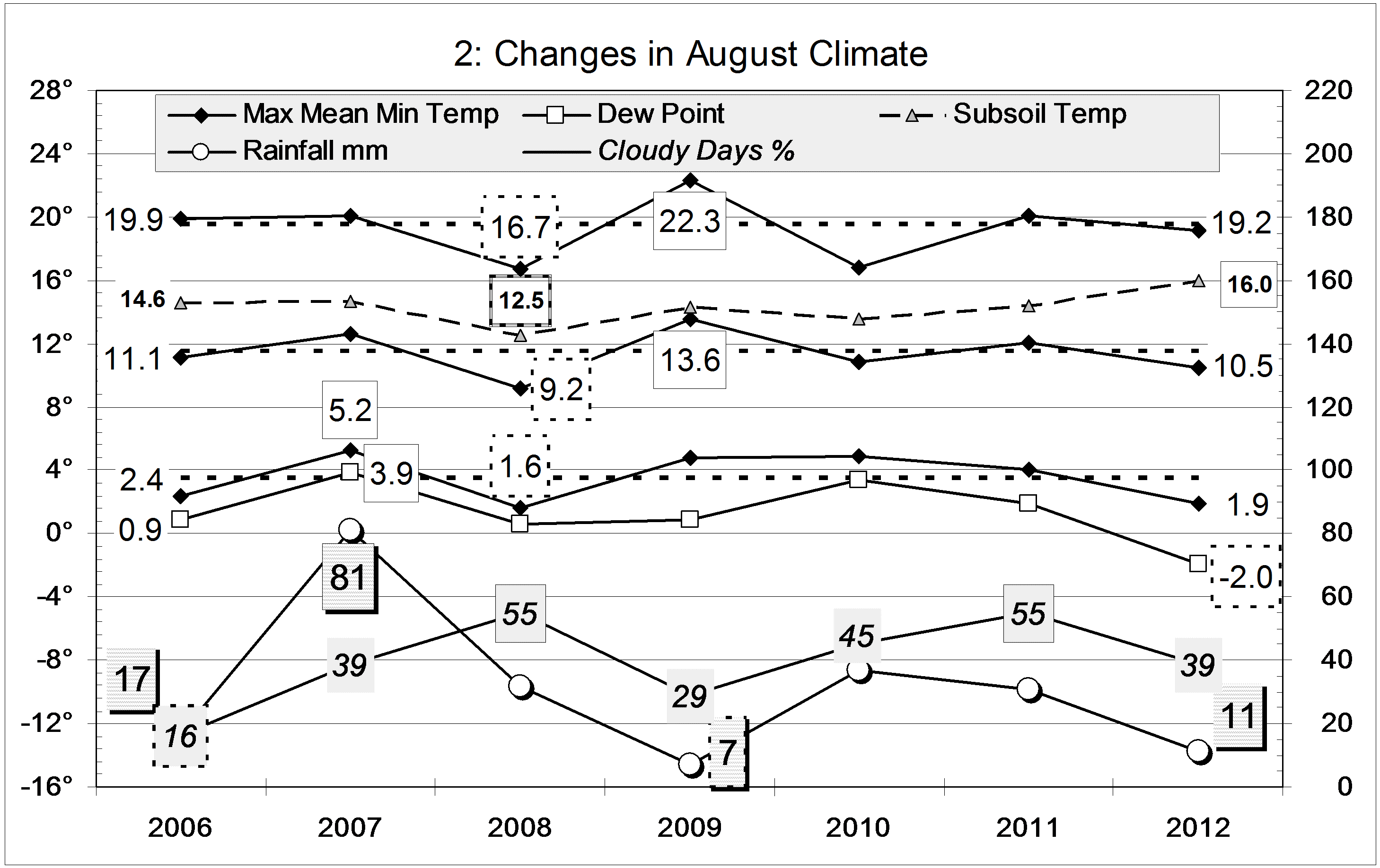
The monthly mean temperature was a bit low, while the mean night-time minimum was very low: 1.9°, not quite as low as the 1.6° of August 2008. The mean early morning Dew Point (-2.0°) was a new record low humidity for any month, beating easily the drought month of July 2002 (-1.4°).
Thirty-nine percent cloudy mornings is a retreat from the August record of 55%, set in 2008 and 2011.
The rainfall of 11.0 mm is very low, in the 15th percentile for August. While the 12-month rainfall total to date is still extremely high (1 metre), the 6-month total is now low (236 mm).


Data. Rainfall data is from Manilla Post Office, courtesy of Phil Pinch. Temperatures, including subsoil at 750 mm, and other data are from 3 Monash Street, Manilla.


3-year trends to July 2012

Parametric plots of smoothed climate variables at Manilla

“Back towards very wet”Trends to July 2012.

Most July 2012 anomalies are close to normal, and like those of the month before. Rainfall, however, is again very high, as in the spring and summer, and daily min temp has gone from very low in May to very high.
The subsoil remained extraordinarily warm. (Why?)

Fully-smoothed data (in red) show that the 13-year record low monthly max temp anomaly of October 2010 (-1.96 degrees) was beaten in January 2012, with a new low value of -2.03 degrees, perhaps to be beaten in the following month. At Manilla, the “flooding rains” climate phase of 2011-12 was very much wetter, and somewhat cooler than that of 2010-11.

Note: Fully smoothed data – Gaussian smoothing with half-width 6 months – are plotted in red, partly smoothed data uncoloured, and raw data for the last data point in orange. January data points are marked by squares. Blue diamonds and the dashed blue rectangle show the extreme values in the fully smoothed data record since September 1999.

Very Wet July 2012

The daily weather logWeather log July 2012.

As in June, most weather features in July were normal, except for very warm nights with the heavy rain in the second week. Sixteen mornings were frosty, one down to minus three degrees. There were several early fogs in the valley.
Of seven rain readings, most were heavy. But the 29.6 mm value included three days.

 Comparing July monthsClimate July 2012.

Other than rainfall, there is only one variable that is not on the July average: the subsoil temperature at 750 mm is again extraordinarily warm, at 16.9°, 3.2° above normal.
The rainfall total of 91.4 mm is in the 94th percentile. Only eight July months have ever been wetter. However, July 1984, at 171 mm, was nearly twice as wet. The 12-month total to the end of July (1020 mm) is extreme. In the last 50 years, only three 12-month totals have been higher: September and October 1998 and February 1984.


Data. Rainfall data is from Manilla Post Office, courtesy of Phil Pinch. Temperatures, including subsoil at 750 mm, and other data are from 3 Monash Street, Manilla.


3-year trends to June 2012

Parametric plots of smoothed climate variables at ManillaTrends to June 2012.

June 2012 anomalies show a return to normalcy for rainfall and maximum temperature. Three moisture-related measures returned to the values of last winter: rather high cloudiness, rather low daily temperature range, and (strangely) rather low Dew Point. Daily min temp returned to the high positive anomaly last seen in 2010.
The subsoil became extraordinarily warm. (Why?)

Fully-smoothed data (in red) show that the 13-year record high monthly rainfall anomaly of November 2011 (+43.8 mm) was not beaten in December, as had seemed likely. The smoothed maximum temperature of December 2011 equalled the record cool anomaly of -1.96 degrees set in October 2010.

Note: Fully smoothed data – Gaussian smoothing with half-width 6 months – are plotted in red, partly smoothed data uncoloured, and raw data for the last data point in orange. January data points are marked by squares. Blue diamonds and the dashed blue rectangle show the extreme values in the fully smoothed data record since September 1999.

Normal Weather in June 2012

The daily weather logWeather log June 2012.

Most weather features in June were normal.: much the same as last year and the year before. Even the frosts were normal. Eleven mornings were frosty, 7 below zero, and 2 below minus 2° (averages: 13, 8, and 2). The coldest morning, Sunday the 24th, was -4.0°. There were several early fogs in the valley but only that on the 24th stayed after 9am.
There were 8 rain days, the highest reading being 21.0 mm on the 3rd.

 Comparing June monthsClimate June 2012.

There is only one variable that is not on the June average: the subsoil temperature at 750 mm is extraordinarily warm, at 18.3°, 3.0° above normal.

The rainfall total of 45.8 mm is within 2 mm of the average (44.3 mm) and in the 60th percentile. Among totals for more than one month, only the 2-, 3-, and 4-month totals are below the median.


Data. Rainfall data is from Manilla Post Office, courtesy of Phil Pinch. Temperatures, including subsoil at 750 mm, and other data are from 3 Monash Street, Manilla.