3-year trends to August 2018

Cooler and Moister

3-year trends to August 2018

August raw anomaly data (orange)

For now, a retreat from drought is shown by lower temperature, particularly at night, and more rain. Dew point remains very low.

 Fully smoothed data (red)

The summer season, ending in February 2018, can now be fully smoothed. February has a new 21st century record [in blue] for smoothed daily maximum temperature anomaly of +1.58° [x-axis all graphs]. This is bound to be broken by smoothed values for March, and perhaps for April. The record for negative rainfall anomaly (set in the drought of July 2002) is also likely to be broken in March.

Through the summer, all three temperatures rose, and rainfall fell. Other variables were static.


Note:

Fully smoothed data – Gaussian smoothing with half-width 6 months – are plotted in red, partly smoothed data uncoloured, and raw data for the last data point in orange. January data points are marked by squares.
Blue diamonds and the dashed blue rectangle show the extreme values in the fully smoothed data record since September 1999.

Normal values are based on averages for the decade from March 1999.* They appear on these graphs as a turquoise (turquoise) circle at the origin (0,0). A range of anomalies called “normal” is shown by a dashed rectangle in aqua (aqua). For values in degrees, the assigned normal range is +/-0.7°; for cloudiness, +/-7%; for monthly rainfall, +/-14 mm.

 * Normal values for rainfall are based on averages for the 125 years beginning 1883.

July 2018 had deep frosts

A young kurrajong tree

Kurrajong in Drought

There were warm spells at each end of the month. Between them, fine cool weather was marked by black frosts with temperatures down to -4.6°. That is colder than had been seen in the sixteen years since 2002. With the freezing nights came extremely low early-morning dew points that beat the previous record value of -10.0°. The new dew point record set on the 22nd was -11.4°.
Six days had light rain. The wettest, on the 6th, registered only 3.2 mm (estimated).

Weather log July 2018

Comparing July months

Despite two nights being below -4°, the number of frosts (17) was normal, as was the mean daily minimum temperature (1.8°). Days, however, set a record mean maximum of 19.2°, making the daily temperature range (17.4°) very high. Other variables were also typical of drought: both cloudy skies (only 19%), and the early morning dew point (-4.0°) were record low values for July. This month was very like July in the drought year of 2002.

The rainfall total of 8.6 mm (estimated) was at the 12th percentile. Persistent low monthly rainfall values have carried the 3-, 4-, and 5-month totals down well below the 1st percentile that marks extreme rainfall shortage. Other totals now classed as “severe shortages” include the six-year total.

Climate in July months

Developing Drought

The rainfall shortages that have now become extreme are covered in other posts, such as “Drought Fifth Month: July 2018”.


Data. A Bureau of Meteorology automatic rain gauge operates in the museum yard. From 17 March 2017, 9 am daily readings are published as Manilla Museum, Station 55312.  These reports use that rainfall data when it is available.  The record was defective for July. Ten daily readings were missing. In addition, 1.0 mm was registered on the 20th when no rain or dew was seen. I have substituted my non-standard gauge readings for all days of July.

All other data, including subsoil at 750 mm, are from 3 Monash Street, Manilla.

3-year trends to July 2018

Hot and Sunny

3-year trends to July 2018

July raw anomaly data (orange)

The on-going drought was reflected in moisture anomalies being near the top of the upper four graphs. In the case of cloudiness (top right), persistently cloudy skies became sunny in one single step.
Both daily maximum temperature and subsoil temperature were very high. As daily minimum temperature (lower left) was normal, the extreme daily temperature range (centre right) was due to the high daily maximum temperature (x-axes) alone.

 Fully smoothed data (red)

The last fully-smoothed data is for January 2018. All variables, except subsoil temperature, continued trends set in the spring. While daily maximum temperature and rainfall were already trending up and to the right towards drought, other variables were not at this time.

Daily maximum temperature anomaly reached a record high (smoothed) value of +1.46°.
Rainfall anomaly approached a record low (smoothed, 21st-century) value.
Cloudiness was static near its normal maximum.
Dew point anomaly was low but slowly rising.
Daily temperature range anomaly was high and steady.
Daily minimum temperature anomaly was high and rising.
Subsoil temperature anomaly, which had been falling, began to rise quite rapidly.


Note:

Fully smoothed data – Gaussian smoothing with half-width 6 months – are plotted in red, partly smoothed data uncoloured, and raw data for the last data point in orange. January data points are marked by squares.
Blue diamonds and the dashed blue rectangle show the extreme values in the fully smoothed data record since September 1999.

Normal values are based on averages for the decade from March 1999.* They appear on these graphs as a turquoise (turquoise) circle at the origin (0,0). A range of anomalies called “normal” is shown by a dashed rectangle in aqua (aqua). For values in degrees, the assigned normal range is +/-0.7°; for cloudiness, +/-7%; for monthly rainfall, +/-14 mm.

 * Normal values for rainfall are based on averages for the 125 years beginning 1883.

Drought Fifth Month: July 2018

Rainfall status June and July 2018

Rainfall shortages at June and July 2018.[Note 13/8/18. The large graph above is an  amended graph. Values in mm are unchanged, but percentile values have been recalculated. The 4-month and 5-month percentile values now plot as less extreme than before. The original graph is on the right.]

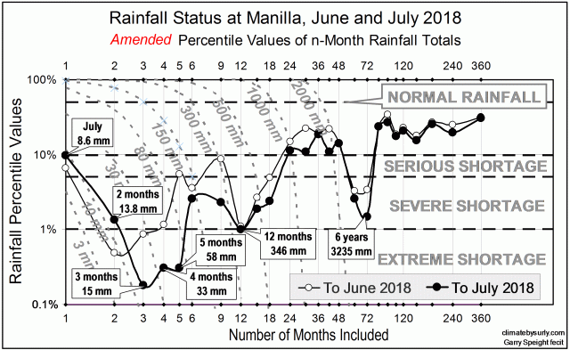
Graph of Rainfall Shortages

This graph shows all the present rainfall shortages at Manilla, short term and long term, in terms of percentile values. The latest values, as at the end of July, are shown by a black line with black circles. Those from one month earlier, at the end of June, are shown by a thinner line with smaller white circles.
The classes of rainfall shortage are:
• Serious shortage: below the 10th percentile;
• Severe shortage: below the 5th percentile;
• Extreme shortage: below the 1st percentile. [See note below on my usage “Extreme shortage”.]

[A graph showing shortages at the end of August is in a later post: “Drought Sixth Month; August 2018”.]

Extreme shortages

At Manilla, the drought is now extreme by several measures.
At the end of July 2018, rainfall shortages are extreme for 3 months (15 mm), 4 months (33 mm) and 5 months (58 mm). “Extreme shortage” means that Manilla has seen such shortages less than 1% of the time since 1883.
Since the end of June, rainfall totals have fallen lower for periods of 3, 4, 5, 6, and 9 months. The 5-month total fell most remarkably. It had been 121 mm, not even a “severe” shortage (below the 5th percentile), but merely a “serious” shortage (below the 10th percentile). It has now fallen to only 58 mm, which is an “extreme” shortage (below the 1st percentile). It is not much higher than the lowest ever 5-month rainfall total of 29 mm, a record set 130 years ago in 1888.

The graph makes it clear that we are now in the fifth month of an extreme drought.

Long-term shortages

At this date, there are no extreme rainfall shortages measured over periods longer than five months. However, there are some severe shortages below the fifth percentile rank. Should rainfall continue to be below average, these shortages could also become extreme. The current twelve-month total of 346 mm needs to fall only 19 mm (to 327 mm) to become an extreme shortage. The 6-year rainfall total (3234 mm) is a severe shortage lower than any since 1962. Rainfall shortages measured over periods of a year or more will not maintain groundwater levels or river flows.

[Note added July 2019.

This drought became very much worse with time. It is clearly one of the six worst droughts in history.
The rainfall status graph for June 2019 shows record-breaking low rainfall values at 15-, 18-, 24-, 30- and 72-month durations.]


Note: The term “Extreme shortage”

I have adopted classes of rainfall shortage from the classes of “Rainfall deficiency” defined by the Bureau of Meteorology in their Climate Glossary as follows:

“Serious rainfall deficiency: rainfall lies above the lowest five per cent of recorded rainfall but below the lowest ten per cent (decile range 1) for the period in question,
“Severe rainfall deficiency: rainfall is among the lowest five per cent for the period in question.
“Areas where the rainfall is lowest on record for the given time period are also shown.”

The Manilla rainfall record allows me to be more exact than the Bureau. Because the record extends back 134 years, it includes more than 1200 cumulative monthly rainfall values. I can identify percentile ranks even below the 0.1th percentile.
To the Bureau’s two classes of deficiency I add a third:

“Extreme deficiency (or extreme shortage): rainfall lies below the lowest one percent for the period in question.”


Short Droughts are Worst

The shorter the drought, the less rainfall there is in it. The longer the drought, the more rainfall. News reports give the false impression that hardly any rain falls during a drought, even if the drought lasts a long time. That is not true.

To prove the point, I have made graphs and a table showing the very worst droughts that Manilla ever had: the very worst short droughts, year-long droughts and 30-year droughts.

Lowest ever rainfalls

Graphs of the driest times

The first graph shows how the driest two month drought had only one millimetre of rain, while the driest longer periods had very much more, up to over 5000 mm of rain in 120 months (10 years). That may seem obvious. So long as there is a little rain in most months, the longer the period, the bigger the rainfall total. But there is more to it than that.

The second graph shows the average rate of rainfall during each worst drought: the rainfall per month. The rate is not steady as you might expect. It too becomes higher as longer droughts are measured. Through the worst two-month drought, only half a millimetre of rain fell per month. Through the worst 12-month drought no less than 24 mm fell per month. The worst 120-month drought had 47 mm per month on average. That is not far below the normal average monthly rainfall of 54.3 mm per month.

The third graph builds on this comparison. Each drought rainfall rate is shown as a percentage of the normal rainfall rate. While those worst droughts that were shorter than than five months had less than 10% of normal rainfall, no droughts that were longer than five months ever had so little. Droughts lasting for 12 months never had rainfall lower than 44% of normal. As for the decade-long droughts mentioned in the news, the driest decades in history had rainfall rates more than 85% of normal. Such record dry times are hard to see in rainfall figures, although they surely deplete surface and underground water storages.

[These graphs show clearly why droughts are not well defined by the percentage of normal rainfall. Percentile values are more satisfactory, but they too have problems.]

Manilla’s list of driest times

Table of lowest rainfallsThe table shows all the figures mentioned for each of the driest times on record in 134 years at Manilla.
Records can be broken, but it seldom happens. These records have stood for a very long time – at least the forty-six years since 1971.

Many of these record-setting droughts had dates of onset or breaking that were members of a rather small set. In particular, the year 1911 saw the onset of nearly half of them.


[This table was amended on 14/8/2018. The original table had two errors, now corrected.
1. The lowest 30-month total was not 1082 mm (36.1 mm/month; 66.5%) set March 1911 to August 1913. It was 1078 mm (35.9 mm/month; 66.2%) set May 1964 to October 1966.
2. There were not 14 rainless months, but 15. The month missed was April 1971.]


A new record set in 2018

The record for 15-month low rainfall of 404 mm, set in 1912, was broken when the 15 months to September 2018 reached only 400 mm.
See the post “Record 15-month Drought in 2018”.

There is a video interview on the topic here:

https://www.prime7.com.au/news/4303-rain-tracker