House June warmth profiles: I

Graph of house temperatures versus height

Where is the warmth in a house?

People are building houses that should keep warm in winter with little heating.
Some parts of the house will stay warmer than other parts. Which parts? How warm?
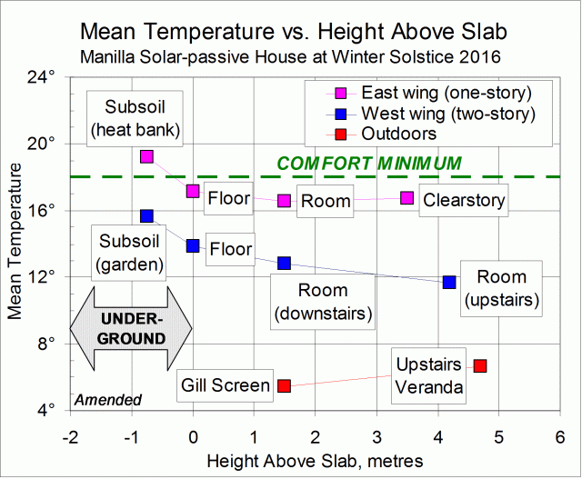
Answers are not easily found. I hope this temperature record from a house with only personal heating may be useful. This was a time when the house was under extreme stress due to cold weather.

Over a five-day period in winter 2016, I read thermometers frequently at a number of stations around the house. I have selected those stations that form profiles from top to bottom of two wings of the house: the two-storied west wing, and the east wing that is one-storied with a clearstory.
To find how my house differs from yours, see the note below: “Key features of the house”.

Selected thermometer stations

In the West Wing (two-storied)

OUTDOORS, upstairs veranda (+4.7 metres);
Wall upstairs at head height (+4.2 metres);
Wall downstairs at head height (+1.5 metres);
Floor slab surface downstairs (0.0 metres);
Garden subsoil at -0.75 metres.

In the East Wing (single-storied)

Clearstory space at +3.5 metres;
Wall in the hallway at head height (+1.5 metres);
OUTDOORS, in a Gill Screen (+1.5 metres);
Floor slab surface in the en-suite (0.0 metres);
Solid “heat bank” beneath the floor slab (-0.75 metres).

Part I: Average temperature values

SUMMARY RESULT
In the ground under the floor slab the temperature would be just warm enough for winter comfort. Above the floor slab, the higher you go, the colder it gets.

Results

The graph above plots mean temperature against height above the floor slab. (The mean temperature is the time-average over the five days.)

Comparing east wing, west wing, and outdoors

The single-storied east wing was several degrees warmer at all heights than the two-storied west wing. The east wing has advantages: thermal mass, perimeter insulation in the footings, less shading, and a more compact shape.
Continue reading

Wet Autumn 2017

Sunset photo.

Manilla Sunset

Autumn this year had normal temperatures, in stark contrast to very high temperatures both in the summer and in the autumn of last year. The decline to winter was not smooth, however, but went by steps. For three weeks in each month there was no cooling then, after some rain, there was a sudden cooling through three, four, or five degrees.
Rain fell frequently except for two gaps of a fortnight each, the first coming in mid-April. The second ended with 32.8 mm of rain registered on May the 20th. There were 26 rain days, which is twice usual number, and more than in any autumn in the new century.

Graphical log for autumn 2017

There was plenty of moisture. Only the early morning dew point (8.1°) was low, by half a degree. The daily temperature range was a narrow 14.5°, and the cloudiness a high 41%.
The total rainfall of 192.8 mm was at the 80th percentile, far above the autumn average of 134 mm. There has not been a wetter autumn since 1990 (203 mm). A little earlier there was a cluster of wetter autumns: 1977 (307 mm), 1979 (203 mm), 1982 (238 mm), 1983 (314 mm: 4th wettest), and 1988 (231 mm). Autumn 1894 was the very wettest, with 388 mm.

Climate for autumn 2017


Data. A Bureau of Meteorology automatic rain gauge operates in the museum yard. From 17 March 2017, 9 am daily readings are published as Manilla Museum, Station 55312.  These reports use that rainfall data when it is available. All other data, including subsoil at 750 mm, are from 3 Monash Street, Manilla.

Warm Wet May 2017

Photo of blossoms on a gum tree

Mugga Ironbark Blossoms

The weather was normal for the first half of the month, bringing a mild first frost on the 11th, close to the normal date for it. Then the weather became warmer and wetter. Rain totalling 32.8 mm was recorded on the 20th, while the minimum temperature of 14.0° that morning was 8.6° above normal. The weekly average temperature rose to 3.8° above normal, before falling below normal as the rain eased towards the end of the month. The last two mornings were frosty.
In all, there were five rain days (over 0.2 mm) when there are usually three.

Weather log for May 2017

Comparing May months

Like May last year, this month was about one degree warmer than normal, unlike May of 2007, which was half a degree warmer again. The dew point (4.7°) was a little low, the daily temperature range (15.3°) normal, the cloudiness (32%) and the rainfall rather high.
The total rainfall of 55.6 mm was at the 70th percentile, well above the May average of 41 mm. There are no shortages of rainfall for groups of months to this date.

Climate for May 2017


Data. A Bureau of Meteorology automatic rain gauge operates in the museum yard. From 17 March 2017, 9 am daily readings are published as Manilla Museum, Station 55312.  These reports use that rainfall data when it is available. All other data, including subsoil at 750 mm, are from 3 Monash Street, Manilla.

3-year trends to May 2017

Parametric plots of smoothed climate variables at Manilla
“Record cold subsoil November 2016”3-year climate trends to May 2017

May raw anomaly data (orange)

While not far from normal, May 2017 was warm and humid (“Interglacial”), in contrast to April, which had been cool and arid (“Glacial”).The daily temperature range remained normal as both maximum and minimum temperature anomalies rose. Subsoil temperature rose above normal.

 Fully smoothed data (red)

The most recent fully-smoothed data point, for November 2016, completes data for the spring season. Following a winter that had been cool and moist, spring showed rapid warming and drying. The November dew point seems to have reached a minimum: one not nearly as low (arid) as in the previous two years.
The smoothed anomaly of daily minimum temperature, which had hit a record high value in May 2016, approached a minimum value that was near normal in October, and began to rise again.
Smoothed subsoil temperature anomaly reached a new record low value of -1.16° in November. It beat a record that was set in March 2008, a few months after the global temperature minimum of October 2007.


Note:

Fully smoothed data – Gaussian smoothing with half-width 6 months – are plotted in red, partly smoothed data uncoloured, and raw data for the last data point in orange. January data points are marked by squares.
Blue diamonds and the dashed blue rectangle show the extreme values in the fully smoothed data record since September 1999.

Normal values are based on averages for the decade from March 1999.* They appear on these graphs as a turquoise (turquoise) circle at the origin (0,0). A range of anomalies called “normal” is shown by a dashed rectangle in aqua (aqua). For values in degrees, the assigned normal range is +/-0.7°; for cloudiness, +/-7%; for monthly rainfall, +/-14 mm.

 * Normal values for rainfall are based on averages for the 125 years beginning 1883.

When is the First Frost?

This year (2017) the first frost at Manilla came on the 11th of May, close to the middle date for it: the 13th of May. In just half of the years, the first frost comes between ANZAC Day (the 25th of April) and the 19th of May.

Graphical record of first frost dates
(See the notes below: “Observing Frosts in Manilla.”)

The date of first frost from year to year

The graph shows the dates of first frosts in the last nineteen years. One feature stands out: from a very early date of the 4th of April in 2008, the dates got later each year to a very late date of the 8th of June in 2014. Otherwise, the dates simply jumped around.

Graphical log of frostsThe date of first frost hardly relates at all to the number of frosts in a season. This graph, copied from an earlier post, shows how poorly they match. The earliest first frost, in 2008, was in a year with a normal number of frosts. In the least frosty year, 2013, the first frost did not come late.

The central date and the spread

To find the central value and the spread of a climate item like this calls for readings for a number of years called a “Normal Period”. (See note below on Climate Normals.) I chose the first eleven years of my readings (1999 to 2009) as my Normal Period. For this period I found these five order statistics:

Lowest (earliest) value: 4th April;
First Quartile value: 25th April (ANZAC Day);
Median (middle) value: 13th May;
Third Quartile value: 19th May;
Highest (latest) value: 24th May.

These five values divide the dates of first frost into four equal groups. For example, the first frost comes before ANZAC Day in one year out of four. This could confirm what Manilla gardeners know already!

Is the first frost getting later?

Talk of global warming leads us to expect the date of first frost to get later. By how much?
Dates on the graph after 2009 seem to be later in the season than during the Normal Period. As shown, a linear trend line fitted to the data points slopes steeply down towards later dates in later years. A curved trend line (a parabola) slopes down even more steeply. However, with so few data points, these trend lines are wild guesses, not to be relied on for forecasting future frosts.
Australian Bureau of Meteorology data for NSW from 1910 shows that daily minimum temperatures have been rising at 0.11° per decade.  (That is much faster than the rate for daily maximum temperatures, which is 0.07° per decade.) To work out how this might affect the date of first frost in Manilla, one needs to know that the daily minimum temperature in this season gets lower each day by 0.15°. One day of seasonal cooling will more than cover a decade of climate warming. The effect of global warming is to make the date of first frost only one day later in fourteen years. If the middle date of first frost was the 13th of May in the Normal Period, centred on 2004, the forecast middle date of first frost next year (2018) would be the 14th of May. This is shown by the flattest of the three trend lines on the graph.

Looking ahead, it seems unlikely that the date of first frost will get later by as much as a week within a lifetime.

[Update 12 August 2019:
This estimate of the median date of first frost, 13 May, is not changed by first frosts observed on 15 May 2018 and 12 May 2019.]


Notes

1. Observing Frost in Manilla

Continue reading