Short Droughts are Worst

The shorter the drought, the less rainfall there is in it. The longer the drought, the more rainfall. News reports give the false impression that hardly any rain falls during a drought, even if the drought lasts a long time. That is not true.

To prove the point, I have made graphs and a table showing the very worst droughts that Manilla ever had: the very worst short droughts, year-long droughts and 30-year droughts.

Lowest ever rainfalls

Graphs of the driest times

The first graph shows how the driest two month drought had only one millimetre of rain, while the driest longer periods had very much more, up to over 5000 mm of rain in 120 months (10 years). That may seem obvious. So long as there is a little rain in most months, the longer the period, the bigger the rainfall total. But there is more to it than that.

The second graph shows the average rate of rainfall during each worst drought: the rainfall per month. The rate is not steady as you might expect. It too becomes higher as longer droughts are measured. Through the worst two-month drought, only half a millimetre of rain fell per month. Through the worst 12-month drought no less than 24 mm fell per month. The worst 120-month drought had 47 mm per month on average. That is not far below the normal average monthly rainfall of 54.3 mm per month.

The third graph builds on this comparison. Each drought rainfall rate is shown as a percentage of the normal rainfall rate. While those worst droughts that were shorter than than five months had less than 10% of normal rainfall, no droughts that were longer than five months ever had so little. Droughts lasting for 12 months never had rainfall lower than 44% of normal. As for the decade-long droughts mentioned in the news, the driest decades in history had rainfall rates more than 85% of normal. Such record dry times are hard to see in rainfall figures, although they surely deplete surface and underground water storages.

[These graphs show clearly why droughts are not well defined by the percentage of normal rainfall. Percentile values are more satisfactory, but they too have problems.]

Manilla’s list of driest times

Table of lowest rainfallsThe table shows all the figures mentioned for each of the driest times on record in 134 years at Manilla.
Records can be broken, but it seldom happens. These records have stood for a very long time – at least the forty-six years since 1971.

Many of these record-setting droughts had dates of onset or breaking that were members of a rather small set. In particular, the year 1911 saw the onset of nearly half of them.


[This table was amended on 14/8/2018. The original table had two errors, now corrected.
1. The lowest 30-month total was not 1082 mm (36.1 mm/month; 66.5%) set March 1911 to August 1913. It was 1078 mm (35.9 mm/month; 66.2%) set May 1964 to October 1966.
2. There were not 14 rainless months, but 15. The month missed was April 1971.]


A new record set in 2018

The record for 15-month low rainfall of 404 mm, set in 1912, was broken when the 15 months to September 2018 reached only 400 mm.
See the post “Record 15-month Drought in 2018”.

There is a video interview on the topic here:

https://www.prime7.com.au/news/4303-rain-tracker

Rainfall Shortages up to June 2018

Rainfall shortage Manilla, June 2018

Since the twelve-month drought of 2002, Manilla has been free from extreme rainfall shortage until now. Such a long gap between extreme droughts has not been seen here before. [See Note below: Dry May 2006.]

Rainfall shortages now

On this graph the black line with black squares shows Manilla rainfall shortages at the end of June 2018. Shortages are shown for short terms down to one month, and for long terms up to 360 months (30 years).

[Shortages at the end of May are shown in a previous post.]

[A graph showing shortages at the end of July is in a later post: “Drought Fifth Month; July 2018”.]

Extreme shortages

Three extreme rainfall shortages have now developed, all below the 1st percentile rank:
Total for two months (May and June): 6 mm;
Total for three months (April, May and June): 24 mm;
Total for four months (March, April, May and June): 50 mm.

Severe shortages

There were five severe shortages in rainfall totals as follows:
Total for six months: 141 mm, at the 4th percentile;
Total for twelve months: 350 mm, at the 2nd percentile;
Total for fifteen months: 492 mm, at the 3rd percentile;
Total for sixty months: 2672 mm, at the 4th percentile;
Total for seventy-two months: 3317 mm, at the 4th percentile.

Serious shortages

Some other rainfall shortages were not severe, but serious:
Total for one month: 5.2 mm, at the 7th percentile;
Total for five months: 120 mm, at the 6th percentile;
Total for nine months: 464 mm, at the 10th percentile;
Total for eighteen months: 658 mm, at the 6th percentile.

Comparing June 2018 with the month before

Continue reading

Rainfall Shortages up to May 2018

Rainfall shortage Manilla May 2018

Rainfall shortages now

On this graph the black line with black squares shows Manilla rainfall shortages at the end of May 2018. Shortages are shown for short terms down to one month, and for long terms up to 360 months (30 years).

Extreme shortages

There were no extreme rainfall shortages at this date.

Severe shortages

There were severe shortages in rainfall totals as follows:
Total for one month (May): 1.2 mm, at the 2nd percentile;
Total for two months (April and May): 19 mm, at the 3rd percentile;
Total for three months (March, April and May): 45 mm, at the 4th percentile.

Serious shortages

Some other rainfall shortages were not severe, but serious:
Total for five months: 136 mm, at the 9th percentile;
Total for twelve months: 408 mm, at the 6th percentile;
Total for sixty months: 2765 mm, at the 8th percentile;
Total for seventy-two months: 3358 mm, at the 6th percentile.

General shortage

The first comment and reply below notes the fact that no rainfall total for any period reaches the 50th percentile. This has not happened for seventy years (1947).

[Later data

The following graph in this series is in the post: “Rainfall Shortages up to June 2018”. For the much worse situation in June 2019, see “June breaks more drought records”. ]

Comparing May 2018 with September 2017

The graph also has a grey line showing similar rainfall shortages at September 2017 (See the earlier post “A drought has begun”.). In the following month, October, there were no rainfall shortages, because the rainfall, 84 mm, was far above average. November, December and February also had rainfalls above average.
Since March 2018, shortages have appeared again. By comparing the black line (May 2018) with the grey line (September 2017), you can see that the rainfall totals are now lower for nearly all periods of time. Only four totals are now higher, including the 4-month total.

What are the classes of rainfall shortage?

We need to compare rainfall shortages. The best way is not by how far below normal the rainfall is, but by how rare it is. That is, not by the percentage of normal rainfall, but by the percentile value. As an example, when the rainfall is at the fifth percentile, that means that only five percent of all such rainfall measurements were lower than that.
Once the percentile values have been worked out for the rainfall record, each new reading can be given its percentile value. Percentile values of low rainfall are classed as extreme, severe, or serious.
For a rainfall shortage to be classed as extreme, its value must be at or below the 1st percentile.
A severe rainfall shortage is one that is below the 5th percentile.
A serious rainfall shortage is one that is below the 10th percentile.
A rainfall shortage that is above the 10th percentile is not counted as serious.

Long-lasting rainfall shortages

Rainfall shortages sometimes last a long time. The same classes of shortage are used for long periods, such as a year, as for short periods, such as a month. They depend on how rare such a shortage is on the average, and they all use the same percentile values to separate extreme, severe, and serious rainfall shortages.

Relations Among Rainfall Moments

Six graphs of rainfall moment relations

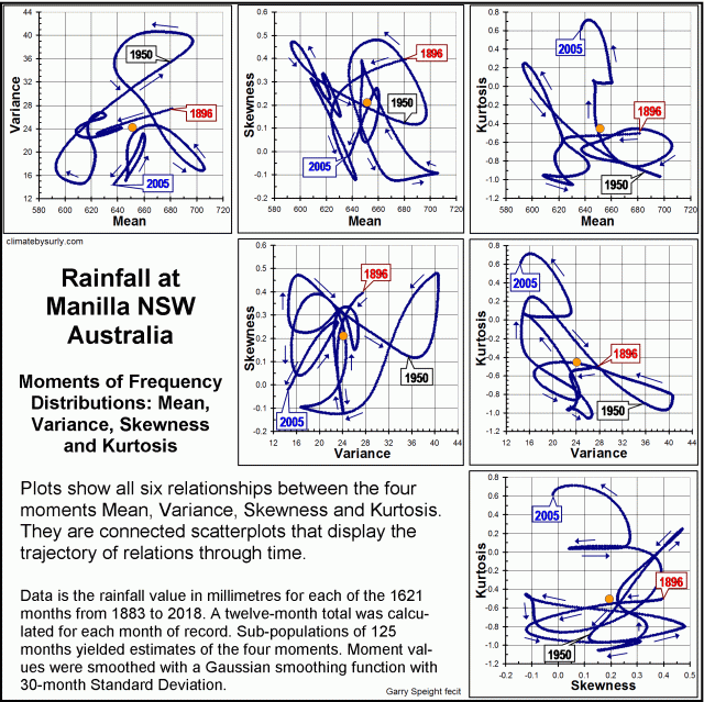
Twelve-monthly values of rainfall since 1883 at Manilla NSW yield the four moments of their frequency distributions: mean, variance, skewness, and kurtosis. I plotted the history of each moment (when smoothed) in an earlier post.
Here, I compare the moments in pairs. Connected scatterplots reveal the trajectory of each relationship with time.
Some linear and cyclic trends persist through decades, but none persists through the whole record.
The first image is an index to the suite of six graphs of pair-wise relationships that I present below.

Rainfall variance vs. mean

Trajectory of Variance versus Mean

Continue reading

Moments of Manilla’s 12-monthly Rainfall

Manilla 12-monthly rainfall history: Four moments

REVISED, WITH MORE PRECISE DATA
Supersedes the post “Moments of Manilla’s Annual Rainfall Frequency” (15 November 2017). This post includes twelve times as much data.[See Note below: “Data handling”]

Comparing all four moments of the frequency-distributions

Yearly rainfall for Manilla, NSW, has varied widely from decade to decade, but it is not only the mean amounts that have varied. Three other measures have varied, all in different ways.

I based the graph on 125-month (decadal) sub-populations of the 134-year record. I plotted data for every month, at the middle month of each sub-population.
I analysed each sub-population as a frequency-distribution, to give values of the four moments: mean (drawn in indigo), variance (drawn in orange), skewness (drawn in green) and kurtosis (drawn in blue).

[For more about the moments of frequency-distributions, see the post: “Kurtosis, Fat Tails, and Extremes”.]

Each trace of a moment measure seems to have a pattern: they are not like random “noise”. Yet each trace is quite unlike the others.

Twenty-first century values are on the right. They are remarkable in three of the four moments. First, the mean rainfall (indigo) stays near the long-term mean, which has seldom happened before. By contrast, two moments are now near historical extremes: variance (orange) is very low and kurtosis (blue) very positive. Skewness (green) is rather negative.

To my knowledge, such a result has not been observed or predicted, or even suspected, anywhere.

[Note. The main difference from the earlier 4-moment graph based on more sparse data is that skewness does not trend downward.]

Manilla 12-monthly rainfall history: Mean

The mean 12-monthly rainfall (the first moment)

The first moment of the frequency-distribution of 12-monthly rainfall is the mean, or average. It measures of the amount of rain.

As I have shown before, the rainfall was low in the first half of the 20th century, and high in the 1890’s, 1950’s and 1970’s. Rainfall crashed in 1900 and again in 1980.

Manilla 12-monthly rainfall history: Variance

12-monthly rainfall variance (the second moment)

Continue reading