February 2012 very wet

The daily weather logWeather log February 2012.

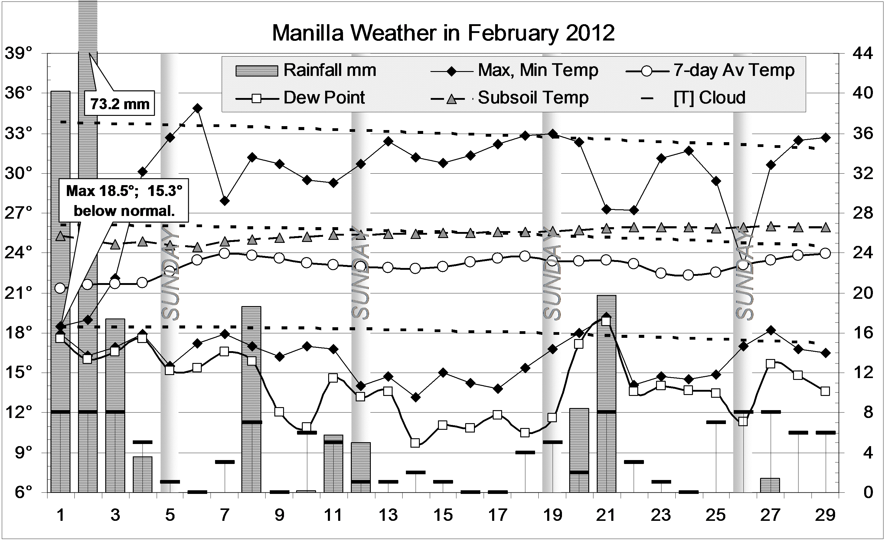
As in December and January, nearly all the days and nights of February were cooler than normal. No days went over 35°, and no nights over 20°. Wednesday the 1st reached only 18.5°, which is 15.3° below normal! Rain that began three days earlier, totalled 145.2 mm by the 4th : one-fifth of a year’s rain in seven days! However, there was no flooding.
In all, February had 11 rain days, totalling 196.3 mm, with 73.2 mm on the 2nd.

Comparing February monthsClimate February 2012.

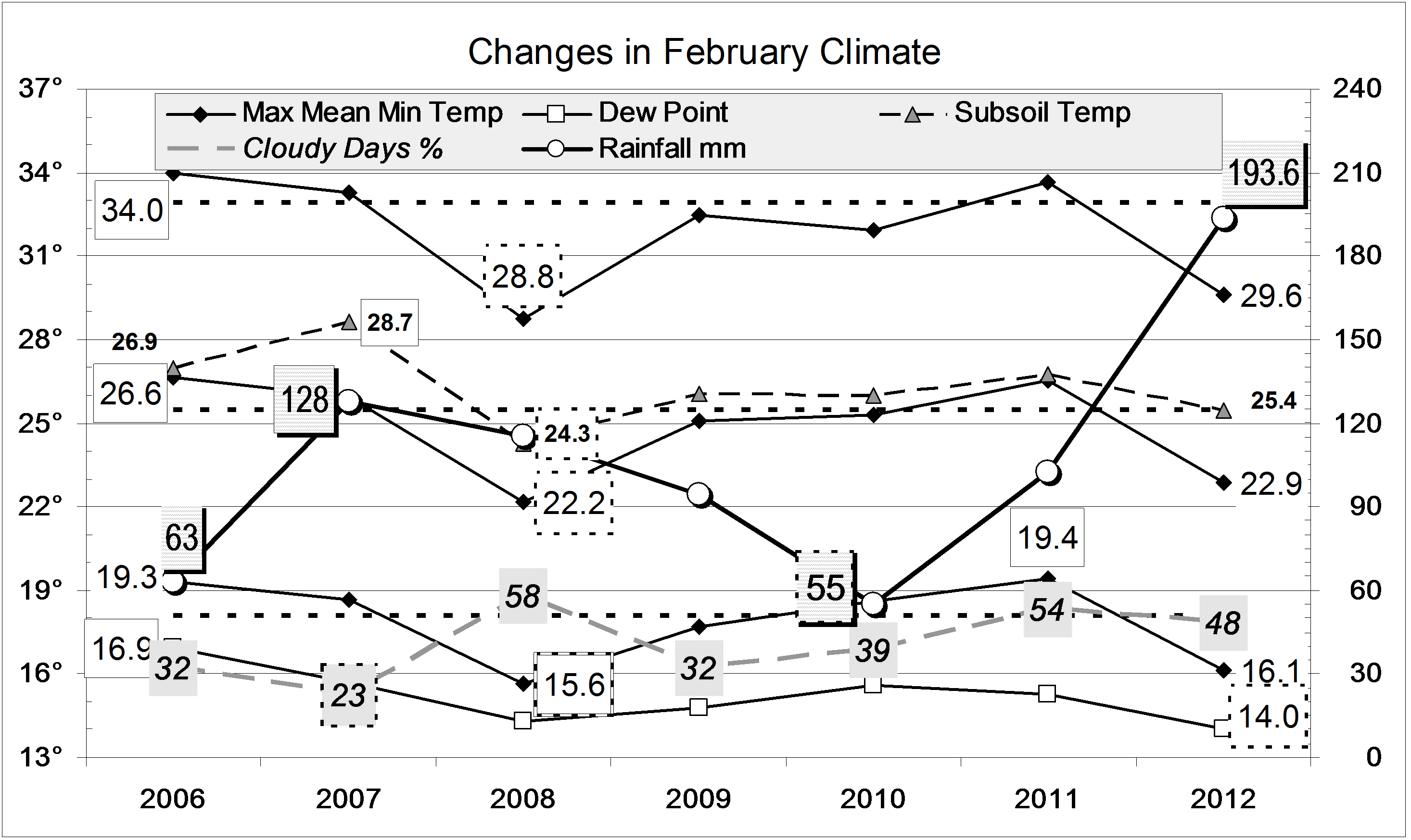
While this month’s mean daily maximum temperature was nearly 3° below normal, February 2008 was cooler on all measures.
The Dew Point was again low: very dry air persists, despite cloudy skies and extreme rainfall.
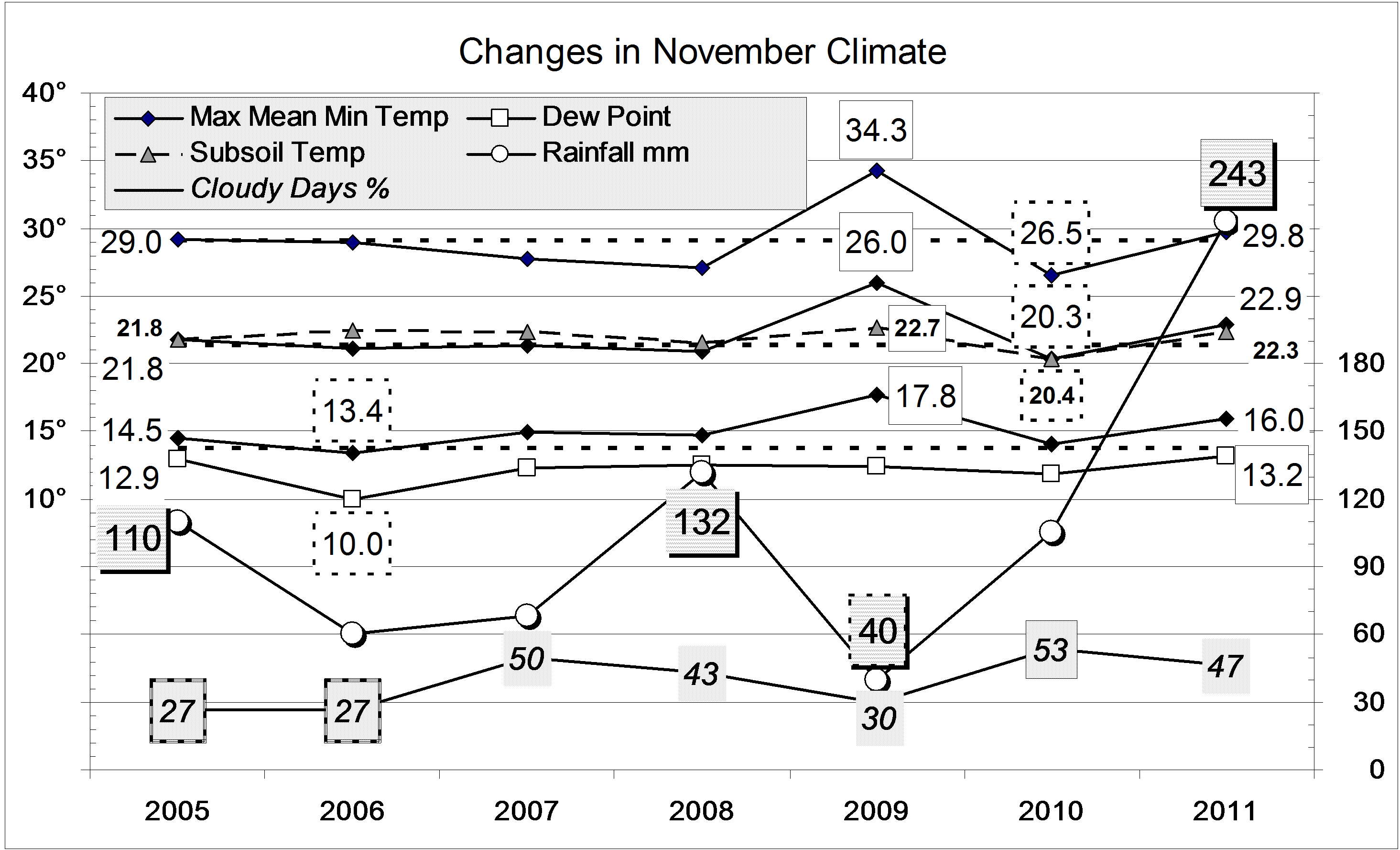
The rainfall of 193.6 mm is in the 97th percentile for February, the fifth wettest in 129 years. As this combines with the November deluge, rain totals for groups of 4, 5, and 6 months have near-record values: 4 months: 576 mm (3rd wettest); 5 months: 674 mm (4th wettest); 6 months: 765 mm (3rd wettest). Total rainfalls for longer periods, up to 30 years, are now all well above average.


Data. Rainfall data is from Manilla Post Office, courtesy of Phil Pinch. Temperatures, including subsoil at 750 mm, and other data are from 3 Monash Street, Manilla.

Cool, very cloudy January 2012

The daily weather logWeather log January 2012.

As in December, nearly all the days and nights of January were cooler than normal. Normally, about twelve days are warmer than 35°, but this time only three were. Sunday the 15th reached only 23°, which is 11° below normal. There were eleven rain days, but the highest rainfall reading, on the 25th, was only 11.2 mm.
The month ended with eleven cloudy mornings in a row. Seven mornings in the month were overcast.

Comparing January monthsClimate January 2012.

All mean temperatures and the Dew Point were lower than in other Januaries shown on the second graph. They were also the lowest on the 13-year record, except that January 2000 had a lower mean minimum of 15.5° and Dew Point of 12.4°. This month’s mean maximum was 3.7° below normal. This extremely low value does not match December’s, which was 4.6° below normal.
Subsoil temperature was not low, but normal. This made the subsoil more than 2° warmer than the air, which is unusual in January.
Fifty-five percent cloudy mornings is a new record for January, and twice as cloudy as usual. Due to that, the mean daily temperature range (13.8°) is near the January record narrow value: 13.7° in 2008.
The rainfall of 60.7 mm is in the 40th percentile for January, well below the long-term average of 86.7 mm. Due to the November deluge, rain totals for groups of months from 3 months up to 24 months remain very high indeed: above the 80th percentile.


Data. Rainfall data is from Manilla Post Office, courtesy of Phil Pinch. Temperatures, including subsoil at 750 mm, and other data are from 3 Monash Street, Manilla.

Very cool December 2011; wet year

The daily weather logWeather log December 2011.

Nearly all the days and nights of December were several degrees cooler than normal. None of them were very cold, but no days and few nights were above normal either. As in much of NSW, cool weather continued for the whole month. In a normal December, most days are warmer than 30°, but this time only four were. There were eleven rain days, often with cloud on the hills and sometimes valley fog (in summer!). The highest rainfall (2 day) reading was 22.0 mm.

 Comparing December monthsClimate December 2011.

This December was even cooler than the last. It set new post-1998 record lows for mean daily maximum temperature (27.0°), mean daily mean temperature (20.4°), and mean daily minimum temperature (13.9°). This December’s days and nights were cooler than those of November, by 2.8° and 2.1° respectively.
Mean early morning Dew Point (11.1°) was also a record low value.
The mean daily temperature range (13.2°) was a bit wider than last years record narrow value (11.7°). The sky was rather cloudy, and the mean subsoil temperature (24.0°) normal.
The rainfall of 79.0 mm is in the 58th percentile for December, above the long-term average of 74 mm. Totals for groups of months up to 24 months are now all extremely high: above the 80th percentile. The greatest rainfall “shortage” is in the 12-year total, which has the lowest percentile value (41st percentile): in the last 12 years 7621 mm of rain fell, which is just 82 mm short of the median 12-year total of 7703 mm.

The year 2011

After a very dry winter, record-breaking spring rain made this an extremely wet year. The rainfall for the year, 839 mm, is in the 86th percentile. It was not quite as wet as 1998 (919 mm; the 6th wettest) or 1996 (890 mm; the 10th wettest). These three years (1996, 1998, 2011) are the wettest in the third of a century since 1978, which had 979 mm.
In other ways, the year was nearer to normal than 2010. There were 91 rain days, fewer than last year’s record 112 rain days. It was much less cloudy, which allowed days to become warmer and nights cooler than last year, when the climate had been more equable: like that on the coast.


Data. Rainfall data is from Manilla Post Office, courtesy of Phil Pinch. Temperatures, including subsoil at 750 mm, and other data are from 3 Monash Street, Manilla.


Spring 2011 the wettest by far


Weather log spring 2011
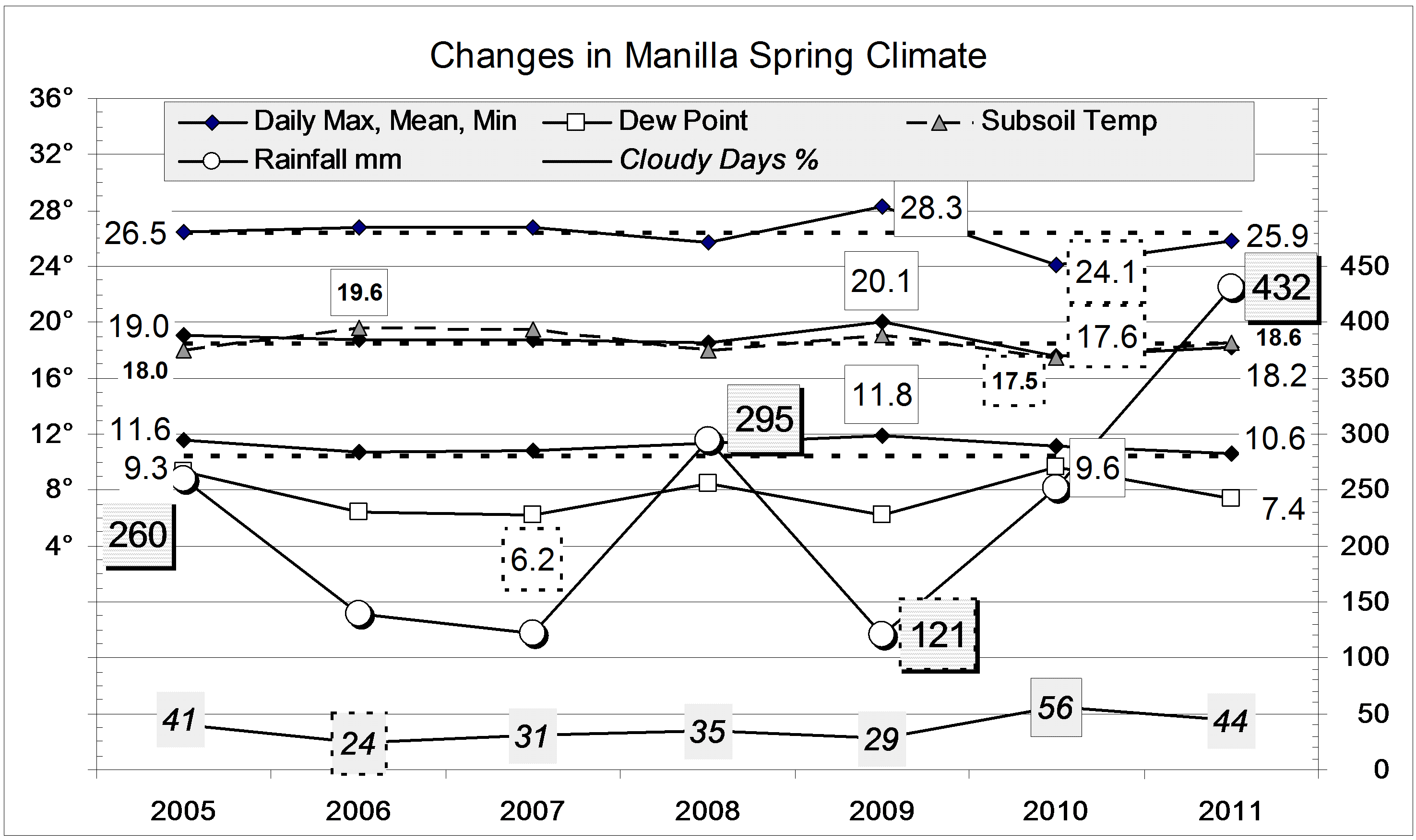
This spring’s rainfall of 431.7 mm far exceeded that of any other spring in the record from 1883. Winter had been very dry, with only 55 mm. While there was a lot of rain in September (91.4 mm) and October (97.4 mm), much more fell in November (242.9 mm), mainly in the second half.
The only other springs with more than 300 mm were in two small groups: 1916 (326 mm) and 1917 (327 mm); and 1949 (330 mm), 1950 (379 mm), 1954 (319 mm) and 1955 (321 mm).
Apart from the extreme rainfall, all other weather readings this spring were normal. By contrast, spring 2009 had been warm and sunny, and spring 2010, cool and cloudy.
During the season, there were two very cool spells, early in September and very early in October. They were separated by a sunny warm spell with very low humidity: it had people changing into summer gear (then back again!). By mid-November, both days and nights were very warm, but then returned to normal.Climate spring 2011

Data. Rainfall data is from Manilla Post Office, courtesy of Phil Pinch. Temperatures, including subsoil at 750 mm, and other data are from 3 Monash Street, Manilla.

November 2011 was the wettest

This was the wettest November, and the fifth-wettest month in the 129-year record.

The daily weather logWeather log November 2011.

After eight sunny dry days, half the remaining days were cloudy and wet. At first it was stormy, with over 60 mm falling in half an hour on the 13th. Persistent steady rain fell later in the month, with daily readings of 47.8, 25.0 and 62.8 mm.. The total reached 242.9 mm.
Some days in the middle of the month were rather warm, balanced later by cool days with the rain. Most nights were a little warm. Taking days and nights together, the weather was warm until the last week.

 Comparing November monthsClimate November 2011.

The record total rainfall of 242.9 mm is more than 100 mm higher than the very high November rainfalls of 2008 (132 mm), 2001 (133 mm) and 2000 (132 mm). All these are far above the November average, which is 67 mm.
Totals for groups of months up to 18 months are all very high. For longer periods, totals are not so high, but all are above the median (the 50th percentile) except for the 10-year total (43rd percentile) and the 12-year total (39th percentile).
Mean daily temperatures are above normal, especially the daily minimum, which is 2° up. However, temperatures in the heat-wave of November 2009 were much higher. This month was humid, with a morning Dew Point a degree higher than normal.


Data. Rainfall data is from Manilla Post Office, courtesy of Phil Pinch. Temperatures, including subsoil at 750 mm, and other data are from 3 Monash Street, Manilla.