Winter 2009 was very warm and dry

Weather log winter 2009

Daily maximum temperatures were mainly above normal throughout the season, except in the second week of June and in mid-July. The values of 31.8° and 30.5° on the 23rd and 24th of August were the hottest winter days in this 11-year record. Many such records were set at that time in Central Australia, southern Queensland and northern NSW. Similarly, daily minimum temperatures were mainly above normal, except in early August. The night-time minimum of 18.2° on 25/8/09 was 2° warmer than the warmest previous winter minimum of 30/8/04.
Early morning Dew Points remained a degree or two below the daily minimum temperature through June and July. In August, they remained low while the temperature soared, so that the air became uncomfortably dry.
There were 20 rain days (usually 18). Most rain came early in the season, with the maximum daily reading only 13.2 mm.
Cloudy mornings declined sharply during the season: June had 60%, July 45%, and August only 29%


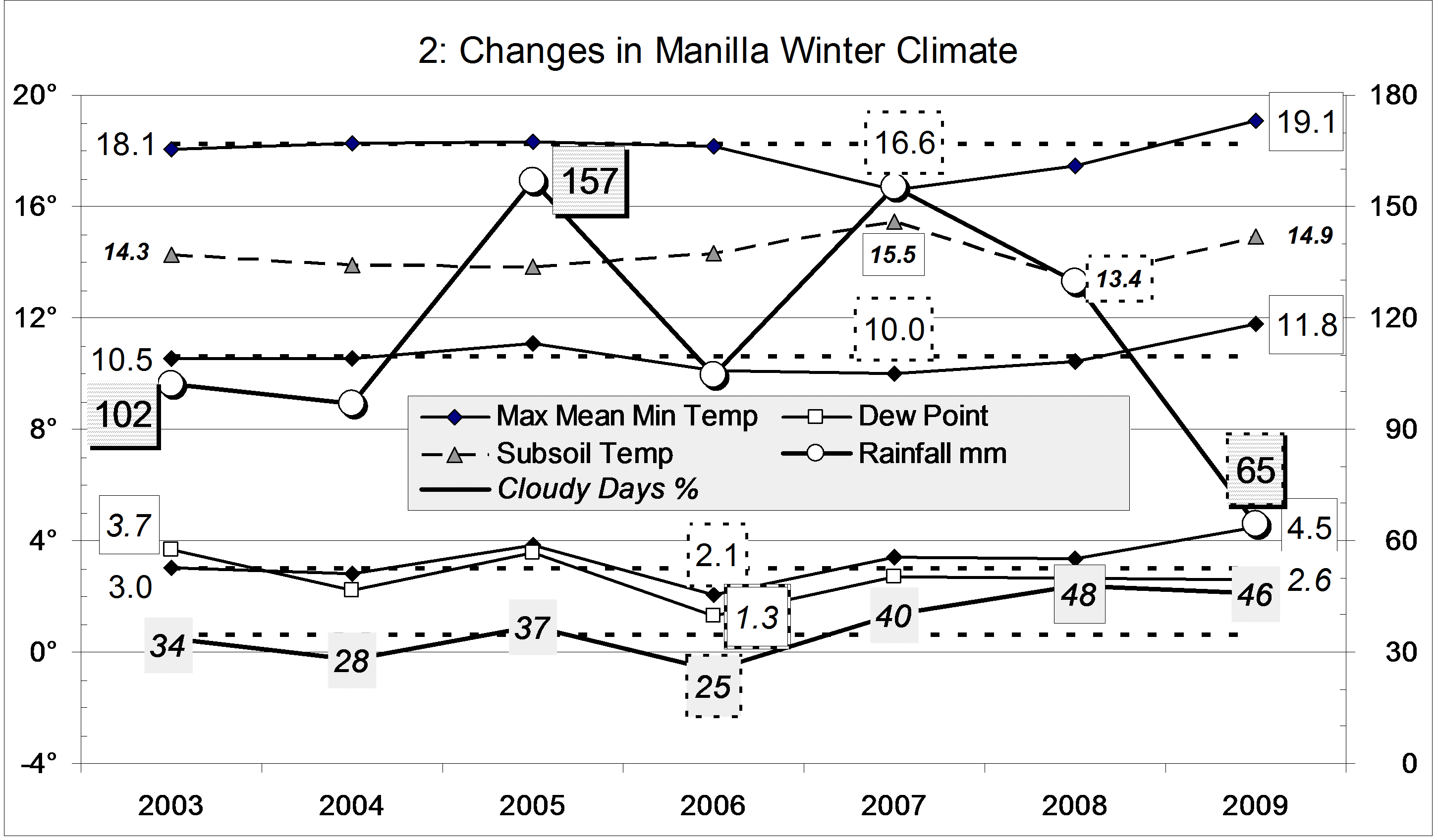
Of the last eleven winters, this was the warmest. The daily mean temperature, 11.8°, was 1.2° above normal. The daily minimum, 4.5°, was also the warmest, but the daily maximum, 19.1°, did not reach the 19.2° of winter 2002.

This winter was one of the least frosty, with 39 frosts rather than the usual 44. There was only one reading below minus two, while other winters had from three to nineteen! The mean Dew Point of 1.7° was normal for winter.
The rainfall total of 65 mm is well below average for winter (125 mm). It is in the 13th percentile, much wetter than winter 2002 which, at 45 mm, was in the 7th percentile.
This was the second cloudiest winter of the decade. Forty-six percent of the mornings had more than 4/8 cloud. Last winter was a little cloudier, at 48%.

Climate winter 2009

Data. Rainfall data is from Manilla Post Office, courtesy of Phil Pinch. Dew Point values before August 2005 are from Tamworth Airport 6am data supplied by the Bureau of Meteorology. Temperature and other data are from 3 Monash Street, Manilla.

June 2008 warm, with rain

The daily weather log

Weather log June 2008

Most of June was very warm. The 7-day average temperature stayed three degrees above normal for the first three weeks. All five rain days came during that time. The first, with 38.2 mm, was the wettest June day in a decade. By the 4th of the month the average rainfall for June (44 mm) had already been beaten. Sadly, the total rose only to 65.2 mm, the same as last year. Around the rainy days the nights were about 7° warmer than usual, and humidity was high (morning Dew Points near 10°). There were frequent fogs, including one on Saturday the 7th that was widespread and thick, and lasted a long time.

The fourth week saw a return to normal June temperatures, with sunny cloudless days. Frosts came back, but there were only eight altogether instead of the usual thirteen.

 Comparing June months

Climate June 2008

This June was warm and humid. However, due to the cool, dry change in the fourth week, it was no warmer or more humid than June of 2005. The graph shows that June 2005 had very high rainfall. It was the sixth wettest June on record.

While this month had more cloud than usual, June last year was much cloudier, and had bitterly cold days – nearly five degrees colder! By contrast, sunny June 2006 had very cold nights, including 21 frosts.
The rainfall total of 65 mm is high. It is in the 78th percentile for June, and nearly twice the median value (36 mm).
The rainfall total for this May and June together (79 mm) is in the 38th percentile of two-monthly totals, while the three-monthly total (99 mm) is in the 23rd percentile. Being above the tenth percentile, these do not count as “serious” shortages of rainfall. The four-month total (101 mm) is a serious shortage: it is only in the 9th percentile. The five-month total is much better (in the 35th percentile). Rainfall totals for longer periods are all normal, that is, near the median.


Data. Rainfall data is from Manilla Post Office, courtesy of Phil Pinch. Dew point values before August 2005 are from Tamworth Airport 6 am data supplied by the Bureau of Meteorology. Temperature and other data are from 3 Monash Street, Manilla.