May 2014 cloudy with warm nights

The daily weather log

Yellow berries  on a White Cedar in May.

White Cedar in May

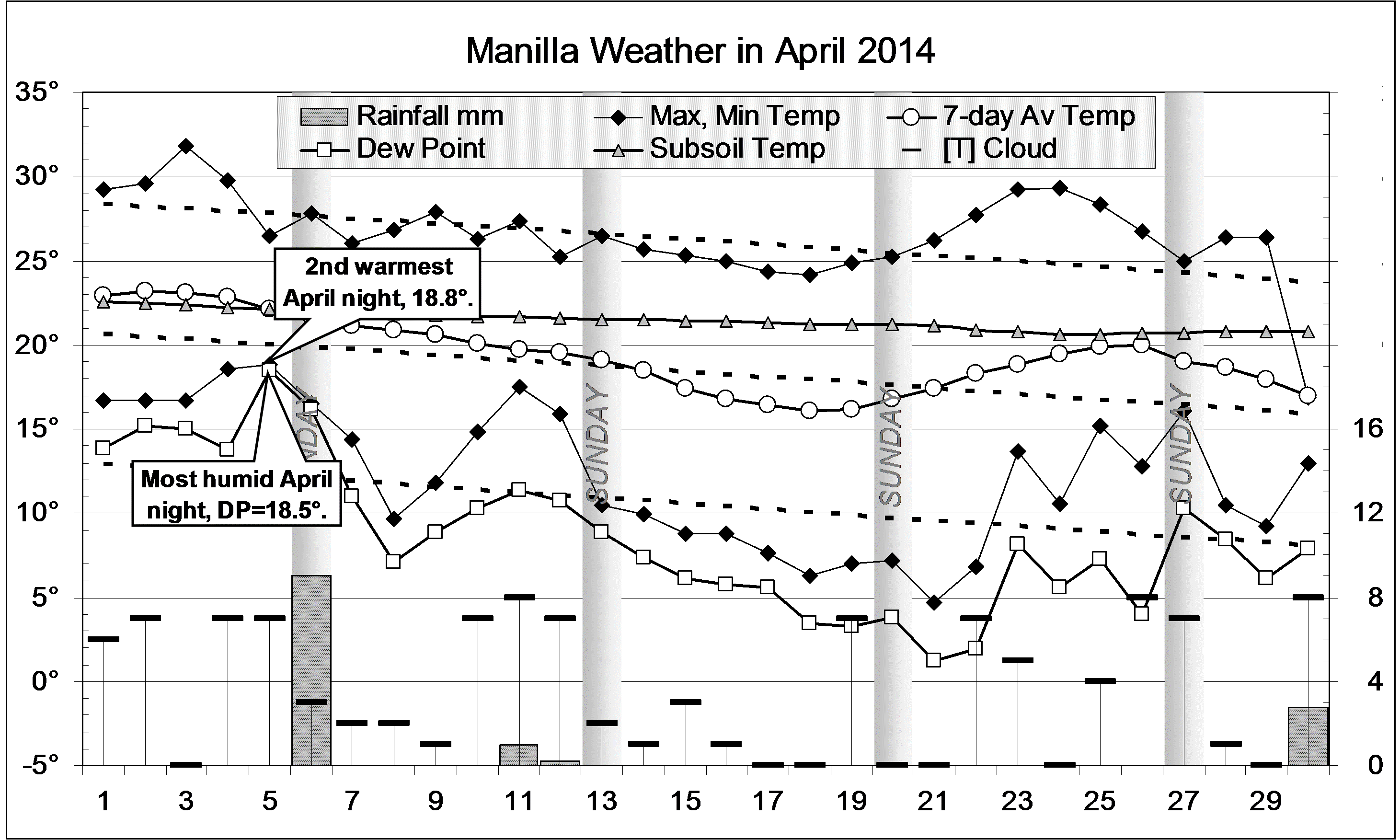
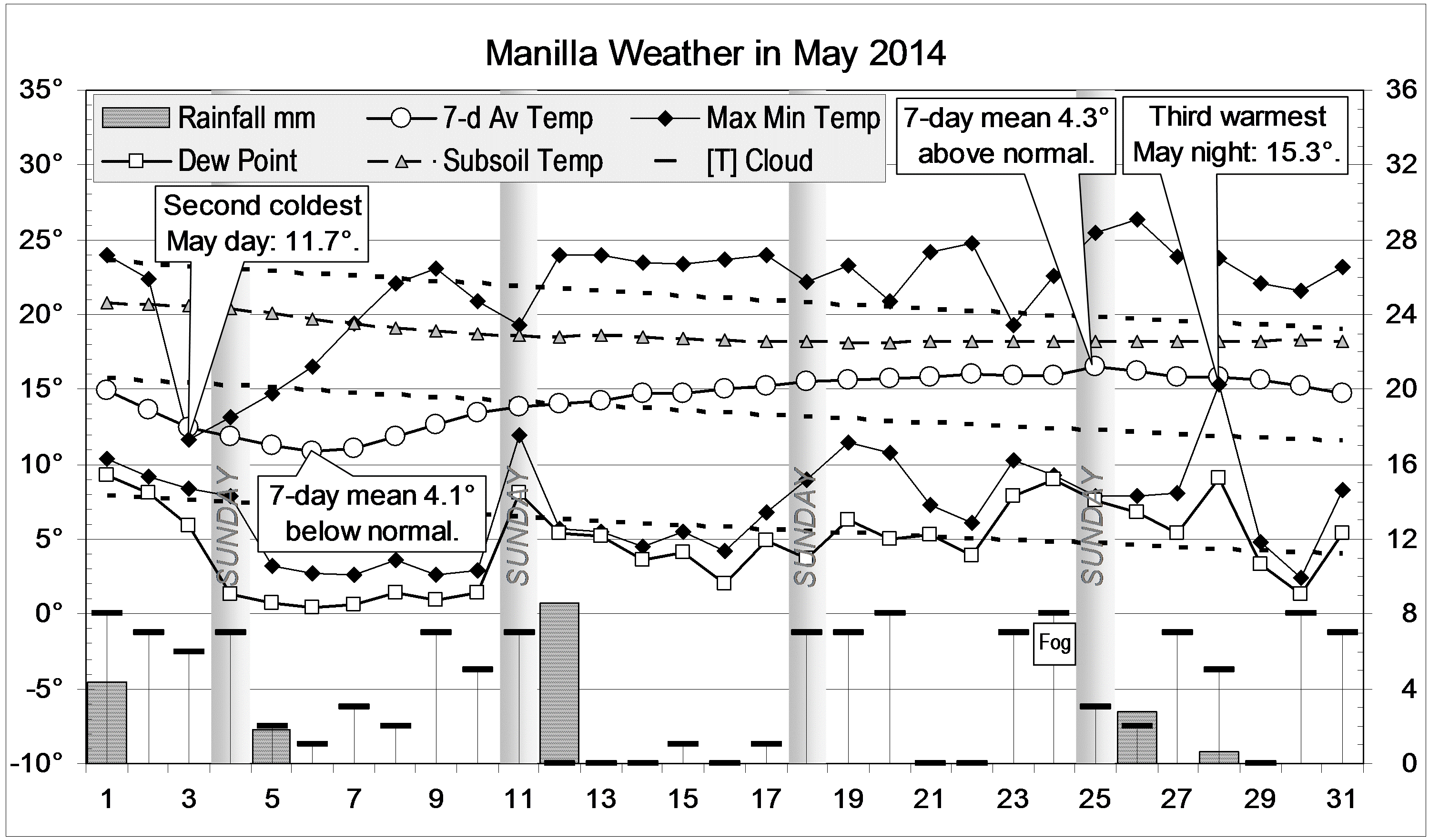
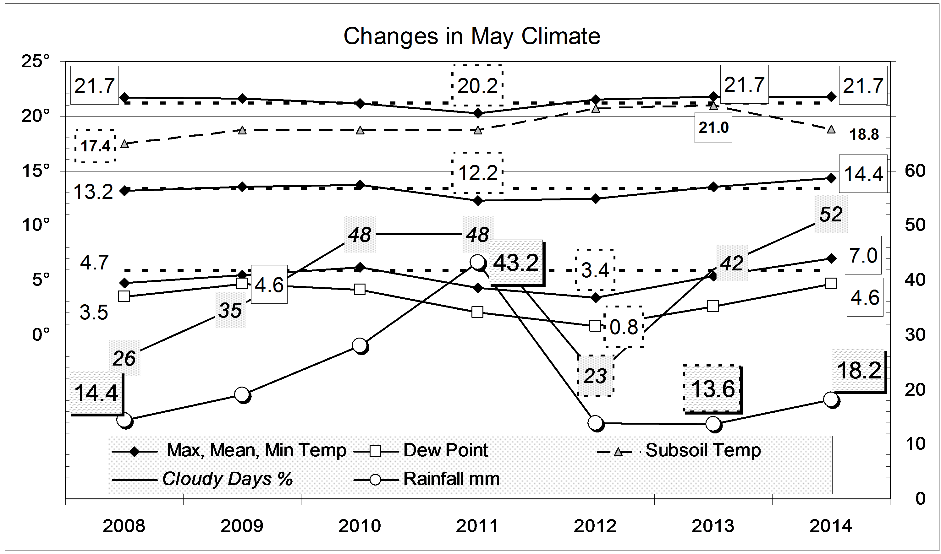
May began cold: the 3rd was the 2nd coldest May day of this century, at 11.7°. By the 6th, the 7-day mean temperature was more than four degrees below normal. Within a week, the weather became warm and, by the 25th, the 7-day mean was more than four degrees above normal. The night of the 26th (15.3°) was the 3rd warmest May night of the century. For the first time, May had no frosts at all, and more than half the mornings were cloudy (>4/8 cloud). There were five rain days, two more than usual.

Weather log May 2014

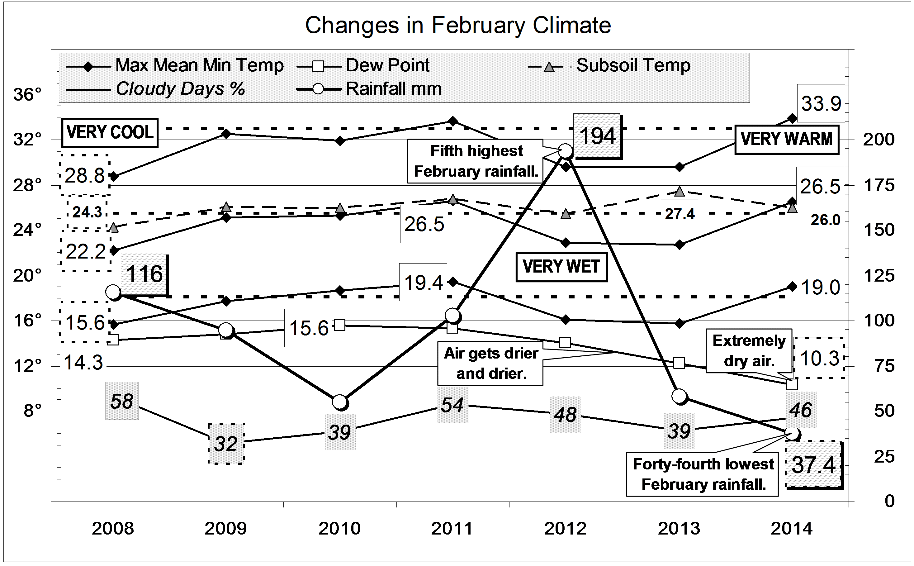
Comparing May months

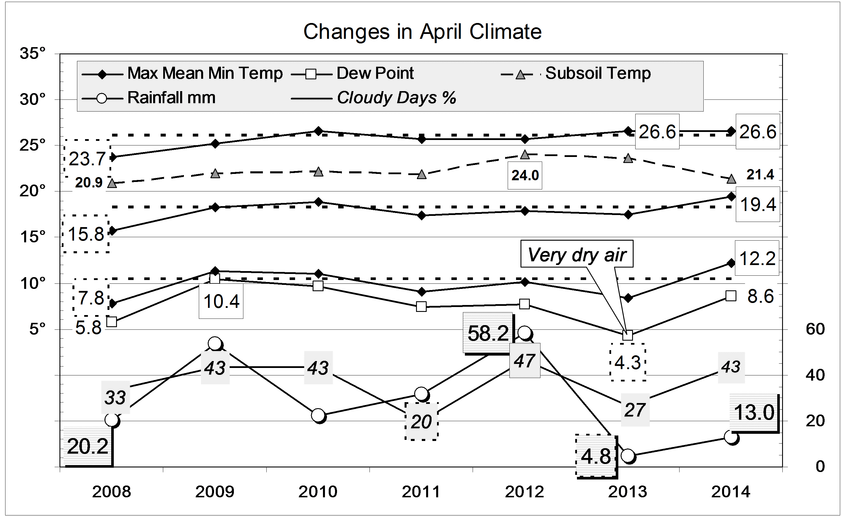
Air temperatures and the dew point were not far from normal. However, as the second graph shows, they are higher than in May months of recent years, such as 2012. Skies were extraordinarily cloudy, but the subsoil temperature was no longer high.
The total rainfall of 18.2 mm is in the 33rd percentile for May. While this is well below the long-term average of 41 mm, it is on the average for the last 15 years. Taking rainfall totals for more than one month, only the two-month total (31 mm) is a serious shortage (9th percentile). The fifteen-month total (585 mm) is in the 12th percentile. Other totals have higher percentile values, and most totals for 36 months or more are above normal. Pools still survive in Greenhatch Creek.

Climate May 2014


Data. Rainfall data is from Manilla Post Office, courtesy of Phil Pinch. Temperatures, including subsoil at 750 mm, and other data are from 3 Monash Street, Manilla.

Warm humid nights in April 2014

The daily weather log

April-blooming Deane's wattle

April-blooming Deane’s wattle

After a cool wet week at the end of March, April began warm, especially at night. The night of the 5th, at 18.8°, was the second warmest April night. Rain fell overnight, and the dew point, 18.5°, was an April record. The third week was sunny but cool, and the fourth week nearly four degrees warmer than usual. The last day of the month was suddenly cold (16.9°) and overcast, with drizzle.Weather log April 2014

Comparing April months

The mean minimum temperature was a record 1.7° above normal for the month, warmer than in April 2005, and the mean maximum temperature was also slightly up. The subsoil, after more than two years above normal (by as much as 2.4° in winter 2013), finally cooled down in March and April.
Moisture was near normal, with low rainfall offset by cloudy skies.
Although the total rainfall of 13.0 mm was below the April average (40 mm), it was not unusually low but in the 28th percentile. Taking rainfall totals for more than one month, the greatest shortages are not serious (i.e. not below the 10th percentile). The nine month total (336 mm) is in the 14th percentile. Other totals have higher percentile values, and most totals for 30 months or more are above normal. Pools still survive in Greenhatch Creek.Climate April 2014


Data. Rainfall data is from Manilla Post Office, courtesy of Phil Pinch. Temperatures, including subsoil at 750 mm, and other data are from 3 Monash Street, Manilla.

Warm Dry February 2014

The daily weather logWeather log February 2014.

The month began sunny and dry, with extremely low humidity. The second week brought a warm spell, which became humid and cloudy, leading to rain. There were eight rain days, with 18.8 mm recorded on the 17th. The fourth week was fine, with normal temperatures.

Comparing February monthsClimate February 2014.

Like February 2011, this month was very warm, but not quite as warm as February 2006. February 2008 had been five degrees cooler, and February 2012 and 2013 also very cool.
The humidity, shown by early morning dew point, has fallen steadily for four February months. It was 15.6° in 2010, and is now a record low of 10.3°. February mean relative humidity values, which had been steady from 2006 to 2013, fell sharply to 2014: afternoon values fell from 31% to 16% and morning values from 80% to 58%.
The total rainfall of 37.4 mm is well below the February average of 67 mm and far below that for February 2012 (194 mm), the fifth wettest on record. This is the forty-fourth driest, and in the 35th percentile. Taking rainfall totals for more than one month, the greatest shortages are not serious (i.e. not below the 10th percentile). The two month total (39 mm) and the twelve-month total (452 mm) are both in the 12th percentile. Other totals have higher percentile values, and most totals for 30 months or more are above normal. Pools survive in Greenhatch Creek.


Data. Rainfall data is from Manilla Post Office, courtesy of Phil Pinch. Temperatures, including subsoil at 750 mm, and other data are from 3 Monash Street, Manilla.

Winter 2013 Warm

Weather log winter 2013

This winter, June was very cloudy and wet, July was very warm, and August was warm and dry. This pattern was common across northern NSW.
There were only 29 frosts, well below the winter average of 44, and fewer than in winter 2010 (32).
All winter average temperatures were above normal: daily max (18.9°), up by 0.8°; daily mean (11.6°), up by 1.2°; daily min (4.3°), up by 1.6°. In each case, winter of 2009 had been slightly warmer. As in last winter, the subsoil temperature was very high: 17.0°, which is 2.7 °above normal for winter in the decade from 1999. In that same decade, only 34% of winter mornings were cloudy; this winter’s value of 43% has become normal since.
The winter rainfall total of 134 mm is just above the average (125 mm) and in the 62nd percentile.Climate Winter 2013

Data. Rainfall data is from Manilla Post Office, courtesy of Phil Pinch. Temperatures, including subsoil at 750 mm, and other data are from 3 Monash Street, Manilla.

Dry, Warm August 2013

The daily weather logWeather log August 2013.

The month had no extremes of heat or cold. Frosts (10) were almost as rare as in August 2011 (9). Some overcast skies came with 5.8 mm of rain on the 17th then, from the 25th, there were five cloudless mornings bringing very warm weather. Altogether, only three days had rain (usually 6).

Comparing August monthsClimate August 2013.

After July having temperatures two degrees above normal, this month’s maximum was only one degree up, and the minimum just on normal. While the air was not as extremely dry as it was last August, the morning dew point was still very low: 2.7 degrees below normal. In contrast, the subsoil temperature remained extremely high, at 16.6°, 2.7° above normal.
Total rainfall is far below the average of 39.5 mm. At 6.4 mm, it is in the 9th percentile: since 1888, only 10 August months have been drier. In totals for two months and more, there is no serious shortage of rainfall, although nearly all totals up to 18 months are now below the median. Totals for all longer periods (up to 360 months) are above the median.


Data. Rainfall data is from Manilla Post Office, courtesy of Phil Pinch. Temperatures, including subsoil at 750 mm, and other data are from 3 Monash Street, Manilla.