Is There Any Drought Now?

No. In Manilla just now, there is no drought of any kind: not a short drought, a medium-length drought, or a long drought; not an extreme drought, a severe drought, or even just a serious drought.

A new comprehensive graph of the severity of drought at one site.

In this graph, each line of data points is for one particular month. The middle line, joining the red squares, shows the whole rainfall drought situation for last month: September 2016.
This is a new kind of graph. (See Note 1 below.) It can show how severe a drought is, not only during the last month or two, but during the last year, and during the last many years. That is a lot of information.

How to read the graph

A month of extreme drought would have data points very low down on the graph. The scale on the left side is amount of rainfall. It must be a “percentile” value. For example: if the amount of rain that fell is just more than has been seen in the driest 5% of all months, it has a value in the 5th percentile. (See Note 2 below.)

Along the top and bottom of the graph I have plotted a number of months.
The number does not show time passing. It shows the number of months I included in a calculation. For each month on record I did many calculations. I added up the total rainfall for:
* the month itself;
* two months including the previous month;
* three months including the month before that;
* … and so on.
I found the totals for larger groups of months extending back as far as 360 months (30 years).
Using all these rainfall totals, I calculated percentile values to plot on the graph. For example, for groups of 12 months, all groups of 12 consecutive months are compared with each other, to find the percentile value of the 12-month period ending in a given month. (See Note 3 below.)

Which months had the most drought and least drought?

The worst drought there could ever have been would be one with data points along the bottom line of the graph. In such a disastrous month, all the rainfall totals would be the lowest on record, not just the one-month total, but also the two-month total and so on up to the 360-month total. Every one of them would be the lowest total on record. It has never been as bad as that.
The “best” time, in terms of being free of drought, would be a month with all its data points along the top edge of the graph. For that month, every rainfall total, for a short period or a long period, would be the wettest on record.
From the Manilla rainfall record, I have chosen to display the most drought and the least drought that actually occurred.

The most drought: August 1946

The month of August 1946 had no rain. Of course, that was the lowest rainfall for any August month (One among 13 months on record that had no rain.). As a result, the percentile rank for that month’s rainfall is zero. Most totals for groups of any number of months ending in August 1946 are also on the “zero-th” percentile, that is, the lowest on record. Thus, it was an extreme drought in the short term, medium term and long term.
For this month, percentile values that are above the third percentile occur in the totals for 48, 60, and 72 months, as shown. These figures, while not extremely low, were still well below normal (Normal is the 50th percentile.). They occur because these totals include some wet months in 1940, 1941, and 1942.

The least drought: March 1894

March 1894, with 295 mm of rain, was one of the the wettest months ever, ensuring a 100th percentile value. The rainfall totals for groups of months ending in that month included six other “wettest ever” values, and all other groups of months were also very wet. No group of months was below the 95th percentile. (See Note 4 below.)

Current drought situation (September 2016)

This month’s rainfall total of 122.4 mm puts it in the 92nd percentile of all monthly rainfall values, far above the median value marked as “normal” on the graph. The 2-month rainfall total (203 mm), and the 4-month rainfall total (350 mm) are almost as high, each in the 90th percentile.
Continue reading

September 2016 had near-record rain

Blooms of Acacia paradoxa

Kangaroo Thorn

There were fourteen rainy days in a month that ended no warmer than it began. The month of September normally warms up by nearly four degrees. This time it remained near 14° all month. Some plants encouraged by the plentiful moisture were discouraged by the cold.
The highest daily rainfall reading, 28.8 mm on the 14th, hardly compares with one of 71.1 mm in 2005, or even one of 40.0 mm in 2011.
No days were warm. For the first time in this 18-year record, no September day reached 25°. More days than ever (18) were below 20° but not one was as low as 15°. Temperatures at night were near normal. A frost on the 5th was the only one. It may have been the last of the year, about a fortnight earlier than usual.
Only four mornings this month had no cloud, while seven were totally overcast.

Weather log for September 2016

Comparing September months

For monthly average temperatures, the daily maximum of 19.7° stands out as a record low, 4.1° below normal. Three indicators for moisture reached their extreme September values for the new century: rainfall, percentage of cloudy mornings (63%), and (narrowest) daily temperature range (12.0°). Dew point (6.0°) was just above normal, but very much higher than in September months since 2010.
The monthly rainfall total of 122.4 mm (amended) was one of the four highest ever September readings. The others were: 1917: 124 mm; 1949: 126 mm; 1998: 166 mm.
There are not now any noteworthy shortages in rainfall totals for any number of months, up to 360 months (thirty years).

Climate for September 2016


Data. Rainfall figures for this month are from the automatic rain gauge at Manilla, published on the internet by the Bureau of Meteorology as Station 55031. All other data, including subsoil at 750 mm, are from 3 Monash Street, Manilla.

Climate trends for thermal soaring

For pilots who soar at Lake Keepit or Mount Borah: relevant summer climate data for Manilla, NSW, since 1999.

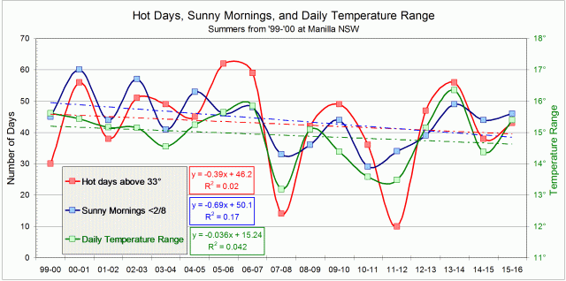
Graph of some summer climate variables 1999 to 2015.

Variables relevant to thermal soaring

From my data I have selected three variables that are relevant to success in soaring flight using thermals. I have chosen to use values for summer: a total or average for the three months of December, January and February.
The variables are:

  • The number of hot days, when the maximum temperature was over 33°C;
  • The number of sunny days, when the cloud amount seen at 9 am was less than two octas;
  • The average daily temperature range in degrees celsius.

Changing values of the variables

The graph shows that each variable fluctuated wildly, with each summer very different from the last. These variables often moved in the same sense.
Two summers had high values of all three variables: 2006-07 and 2013-14. Two summers had low values of all three variables: 2007-08 and 2011-12. I would expect that longer and faster thermal soaring flights would have been achieved in the summers with high values, compared to those with low values.

Trends

I have fitted linear trend lines, and displayed their equations within the graph.
All three trend lines slope down. This suggests that summer thermal soaring conditions have been getting worse.
I have cited the values of “R-squared”, the Coefficient of Determination. All three R-squared values are abysmally low. Even the best is below 20%, which can be taken to mean that more than 80% of the variation has nothing to do with the trend line shown.
You could say that the trends are nonsense, but we are dealing with Climate Change here!

The future

In the spirit of Mark Twain, we can extend the trend lines forward to where they come to zero:

  • There will be no hot days above 33° by the summer of 2118;
  • There will be no sunny mornings with less than 2 octas of cloud by 2073;
  • Days will be no warmer than nights by 2423.

That last date seems too remote to worry about. However, the daily temperature range will be unacceptable when it gets down to 11°. That is the current summer value for Lasham, England, after all. According to the trend, the daily temperature range will be worse than at Lasham by 2117. That is the same year that the very last 33° day is expected.

Global Warming

You may be surprised that the linear trend lines fitted to this data set slope downwards. It seems to contradict Global Warming. Continue reading

Hard Winter for Solar-passive

Graphical log of daily indoor and outdoor temperatures for winter 2016.

Temperature log: main features

This graph, for 2016, shows a winter pattern of indoor and outdoor temperatures that is typical for this house. Indoor temperatures vary much less than outdoor temperatures, they rise and fall with them, and they are higher nearly all the time.
While the outdoor temperatures shown go as low as minus three degrees, those indoors lie within the winter “comfort zone” from 17° to 24° (see this post) nearly all the time.

Weather this winter

This winter was harsh for a solar-passive house. Near-record rainfall (227 mm) came with the greatest number of cloudy days of any winter in the new century. There were 53 mornings with more than four octas of cloud, when the average is 33.

Heater use

Because cloud limited the the solar gain, I had to use blower heaters far more than in previous winters. My records show that I used 320 kWh ($80) in these heaters this winter, when I normally use about 40 kWh ($10).
Heaters were also used by guests who were present on the six days shown. As well as being unused to the climate, the guests lived in the colder west wing of the house. They may have used 72 kWh ($18). Those guests have kindly written reviews of their visit.
Even using 400 kWh of electricity for personal heating in a winter could not make a detectable change in house temperature. I have found that blower heaters are surprisingly good at making a room in this house comfortable. As the radiant temperature of the walls is only 2° or 3° too low for comfort, it can be compensated by making the air temperature only slightly higher.

The pattern in detail

While cloudy days are not plotted here (Cloud observations for this winter are plotted elsewhere.), cloudy days can be recognised on the graph. In this climate, days with low maximum temperature and high minimum temperature are always due to cloud. Only in fine weather are days warm and nights frosty. The graph shows how the weather goes through a cycle every week or two: sunny days get warmer, then rain sets in. As it clears, the air gets even colder, before warming up again.
Indoor temperatures follow the same cycle, but there are differences. There may be a delay of up to a day, and sometimes longer.

Correlations

I did scatter plots comparing all the variables shown in the first graph and I fitted linear regressions. I present the four scatter-plots that had the highest coefficients of determination (“R-squared”). Continue reading

Wet August 2016 had two cold days

Photo of knife-leaf wattle blooms

Knife-leaf Wattle

Six days with at least eight millimetres of rain made for a very wet August.
On the average, the temperature was normal until the fourth week, which was cool. However, there were two remarkably cold days. The 3rd, at 10.6°, was the second coldest August day and the 22nd, at 11.6°, the fifth coldest. Most nights were cool, around 1°, but several were much warmer, generally with the rain. Most days were sunny, and eighteen of the mornings were frosty, about three more than usual.

Weather log for August 2016

Comparing August months

On average, the days were cold: as cold as in August 2001, but not as cold as in 2008 or 2010. The average night-time temperature, however, was normal. The dew point, while not high, was higher than in the previous four August months.
The monthly rainfall total of 80.2 mm was twice the average (40 mm), and in the 89th percentile. No rainfall total for any number of months is now below the 19th percentile. That is the 42-month total of 1949 mm, which is a mere 313 mm lower than the median 42-month value. Both Greenhatch Creek and Rushes Creek have flowed in recent weeks.

Climate for August 2016


Data. Rainfall figures for this month are from the automatic rain gauge at Manilla, published on the internet by the Bureau of Meteorology as Station 55031. All other data, including subsoil at 750 mm, are from 3 Monash Street, Manilla.