3-year trends to November 2011

Parametric plots of smoothed climate variables at Manilla

“Bizarre values of climate anomalies”Trends to November 2011.

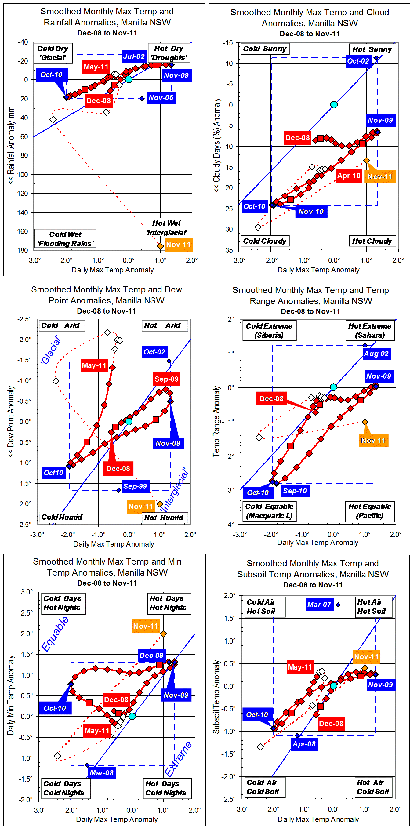
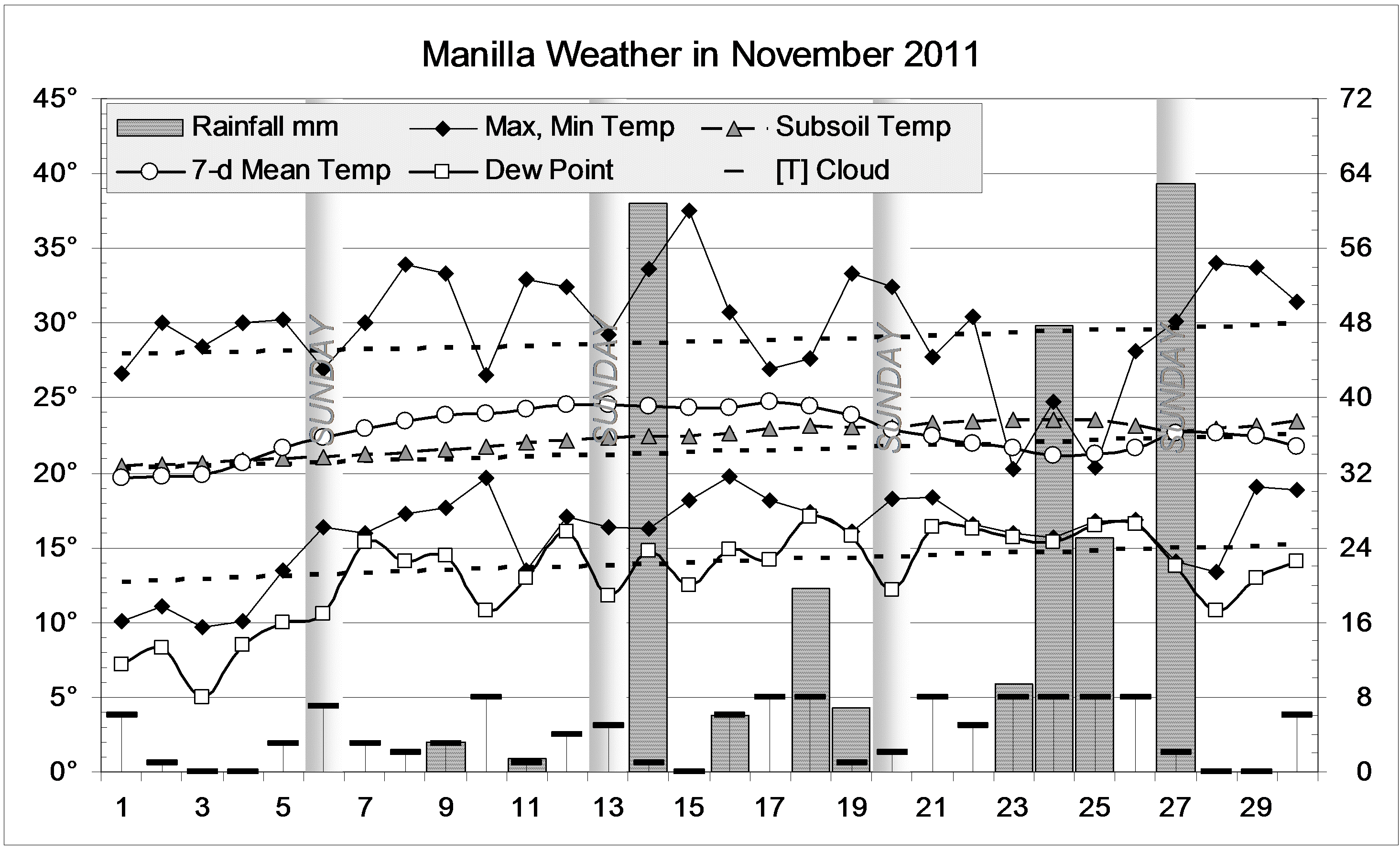
Most raw values for variables for November 2011 are bizarre. The rainfall anomaly (top left) is so high the scale has had to be extended by four times. The daily maximum temperature anomaly (all graphs, x-axis) has jumped from very low to high. High temperature seldom occurs with high rainfall, but that is thought to be normal in an interglacial climate. Similarly for the high Dew Point (centre left) with high maximum temperature. Two other temperatures jumped up along with maximum temperature: minimum temperature, and subsoil temperature.

Fully-smoothed data points (red) are now available for the autumn months (MAM) of 2011. Each variable showed a steady trend in one direction (but this did not continue through winter).
Max temp increased towards normal.
Rainfall decreased through normal.
Cloudiness was high but decreasing.
Dew Point (humidity) was below normal and falling very rapidly.
Temperature Range was rising towards normal.
Min temp was falling through normal as max temp was rising: a trend from equable towards extreme.
Subsoil temperature increased with maximum temperature.

Note: Fully smoothed data – Gaussian smoothing with half-width 6 months – are plotted in red, partly smoothed data uncoloured, and raw data for the last data point in orange. January data points are marked by squares. Blue diamonds and the dashed blue rectangle show the extreme values in the fully smoothed data record since September 1999.

November 2011 was the wettest

This was the wettest November, and the fifth-wettest month in the 129-year record.

The daily weather logWeather log November 2011.

After eight sunny dry days, half the remaining days were cloudy and wet. At first it was stormy, with over 60 mm falling in half an hour on the 13th. Persistent steady rain fell later in the month, with daily readings of 47.8, 25.0 and 62.8 mm.. The total reached 242.9 mm.
Some days in the middle of the month were rather warm, balanced later by cool days with the rain. Most nights were a little warm. Taking days and nights together, the weather was warm until the last week.

 Comparing November monthsClimate November 2011.

The record total rainfall of 242.9 mm is more than 100 mm higher than the very high November rainfalls of 2008 (132 mm), 2001 (133 mm) and 2000 (132 mm). All these are far above the November average, which is 67 mm.
Totals for groups of months up to 18 months are all very high. For longer periods, totals are not so high, but all are above the median (the 50th percentile) except for the 10-year total (43rd percentile) and the 12-year total (39th percentile).
Mean daily temperatures are above normal, especially the daily minimum, which is 2° up. However, temperatures in the heat-wave of November 2009 were much higher. This month was humid, with a morning Dew Point a degree higher than normal.


Data. Rainfall data is from Manilla Post Office, courtesy of Phil Pinch. Temperatures, including subsoil at 750 mm, and other data are from 3 Monash Street, Manilla.


November 2010: more cool, cloudy, wet weather

The daily weather log

Weather log November 2010 Manilla

As in October, November’s days were very cool: only 5 days went above 30°.
Rain fell on 11 days. The highest reading was 21.0 mm on the 12th.

Comparing November months

Climate November 2010 Manilla

The mean daily maximum temperature (26.5°) was the lowest for November on this 12-year record. The mean daily temperature range (12.4°) was (with November 2008) a record low value.
Mean subsoil temperature (20.4°) was the lowest since November 1999. The month ended with subsoil temperature (then 22.2°) trailing only 10 days later than its usual date. It had begun the month 22 days late.
There were more cloudy mornings (53%) than in any November on this record.
The rainfall of 105.4 mm is in the 84th percentile for November, far above the long-term average of 67 mm. Totals for groups of months up to 15 months are now all above the median, as is the thirty-year total.


Data. Rainfall data is from Manilla Post Office, courtesy of Phil Pinch. Temperatures, including subsoil at 750 mm, and other data are from 3 Monash Street, Manilla.

November 2009 – Extreme Heat

The daily weather log

Weather log November 2009

November 2009 broke records for heat at any time of year in the last decade:
Highest daily maximum temperature: 42.6° on 20/11/09;
Highest daily minimum temperature: 27.8° on 22/11/09;
Highest weekly average: 31.3° for 17-23/11/09.
The daily maximum on the 20th was a record 13.5° above normal, and the daily minimum on the 22nd was one of only three nights over 13 degrees above normal.

 Comparing November months

Climate November 2009

Mean monthly temperatures were the highest on record for November: mean daily maximum 34.3° (5.2° above normal); mean daily mean 26.0° (4.6° above normal) mean daily minimum 17.8° (4.0° above normal). The early morning Dew Point (10.9°) was normal, but hot air brought the Relative Humidity down.
Rainfall of 33.4 mm recorded on the 9th was welcome, but little fell later. In all, five rain days totalled 40.0 mm. This total is low: in the 28th percentile for November. Most totals for more than one month are fairly good but a severe shortage (3rd percentile) affects the 9-month total (266 mm).


Data. Rainfall data is from Manilla Post Office, courtesy of Phil Pinch. Temperature and other data are from 3 Monash Street, Manilla.


November 2008 cool and very wet

The daily weather log

Weather log November 2008

This November was like last November, but wetter. Again, a sunny dry week separated times of overcast rainy days.
Sudden cold changes, which had come twice in October, came again on the 8th, 17th, and 22nd. The last was severe. The maximum on the 23rd was nearly 12° below normal. The temperature that day did not rise above 15° until 5 pm!
Steady soaking rain on the 3rd amounted to 44 mm. A long spell of six rain days from the 17th brought another 48 mm. It began as persistent drizzle but included storms (one with 15 mm size hailstones). These days had low cloud and high humidity. Extremely low humidity (Dew Point 0.1°) came with the cold change, but dew points rose to a peak of 17.4° on the 29th. Over 26 mm of rain fell that day.
Manilla missed two heavy rainstorms of 80 mm each that swept through Tamworth at 10 am and 10 pm on the 28th. There was flooding at Tamworth, at Carroll Gap, and on the plain east of Gunnedah. The Namoi River at Manilla also rose due to rain near Bendemeer.

 Comparing November months

Climate November 2008

Days were the coolest in ten Novembers. However, the mean daily minimum was high, making the daily temperature range (12.4°) even narrower than last November. This agrees with high values for cloudiness and dew point.

The rainfall total, 132 mm, is far above the long-term November average of 67 mm, but that is now common. Five of the last ten Novembers had 110 mm or more. This month and November 2000 were equal ninth wettest on record, and November 2001 (133 mm) eighth wettest.
The rainfall totals for groups of months get higher and higher. The total for 2 months (October and November) is in the 94th percentile, 3 months in the 92nd, 4 months in the 86th, 5 months in the 80th, and 6 months in the 81st percentile. Totals are now above the median for periods up to 72 months with only one exception: that for 9 months is in the 47th percentile. The six-year total rainfall is now 100 mm more than in six average years.


Data. Rainfall data is from Manilla Post Office, courtesy of Phil Pinch. Dew point values before August 2005 are from Tamworth Airport 6 am data supplied by the Bureau of Meteorology. Temperature and other data are from 3 Monash Street, Manilla.