December 2012 Hot, with Rain

The daily weather logWeather log December 2012.

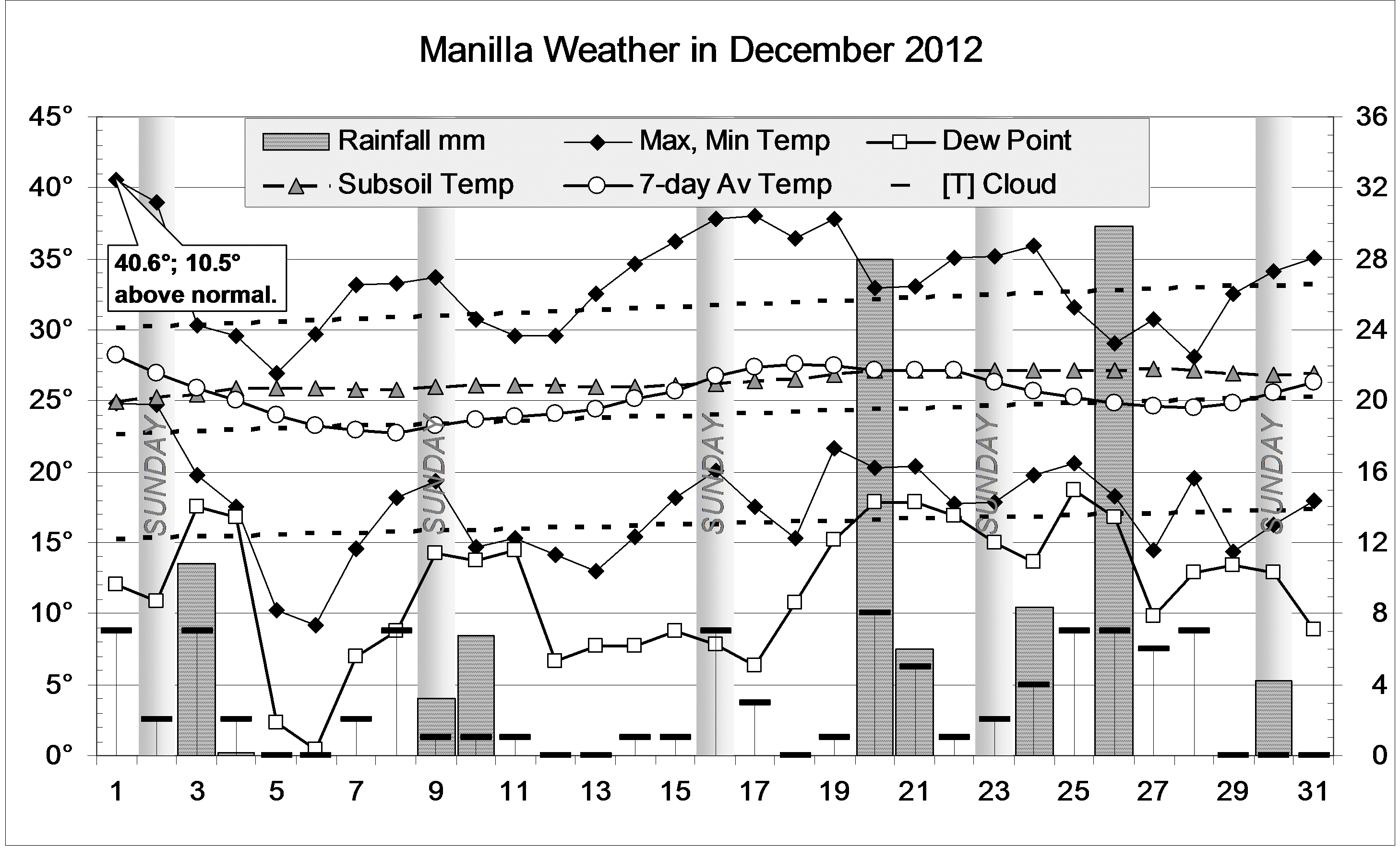
As in November, most days this month were warmer than normal. The 1st, at 40.6°, was the equal hottest December day on this record, with 30/12/05.
Afternoon values of Relative Humidity fell to 7 percent on the 15th and 16th.
Rain was recorded on nine days, totalling 97.4 mm, with the highest reading 29.8 mm on the 26th.

 Comparing December monthsClimate December 2012.

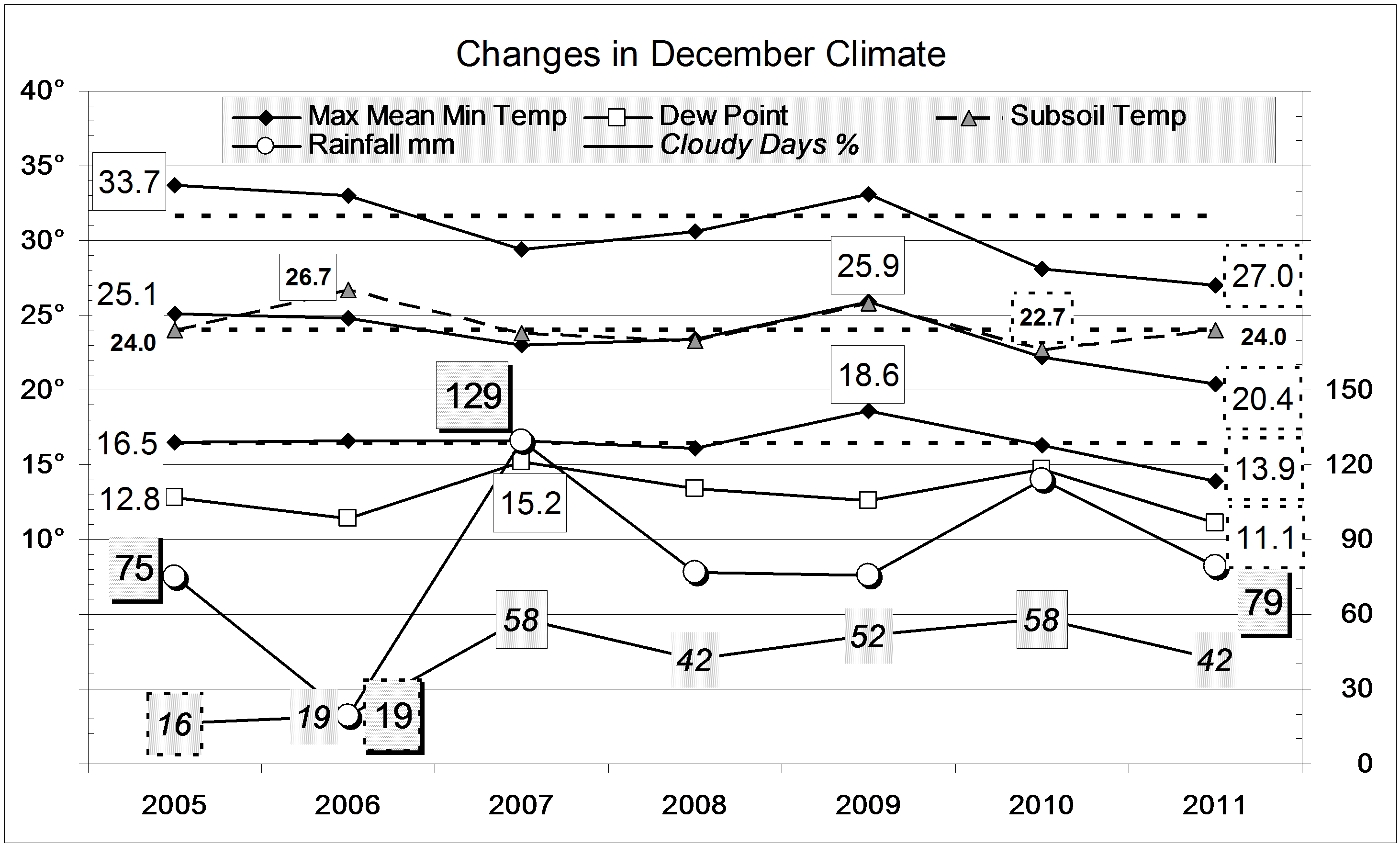
Days this month, at 33.3°, were not quite as hot as those of December 2005 (33.7°). Nights this month were warm (17.5°), but not nearly as warm as those of December 2009 (18.6°). In stark contrast, December 2011 was several degrees cooler.
The mean early morning Dew Point of 11.7° shows the air is almost as dry as it was a year ago. Since then, the air has been even drier, with an extremely low morning Dew Point of 1.7° in October.
The sky was less cloudy than in any of the last five Decembers.
The rainfall of 97.4 mm is high, in the 72nd percentile for December. This defers all concerns about rainfall shortages: even the five-month total of 190 mm is in the 25th percentile.

The Year 2012

In 2012, rainfall was extremely high in February, April, and July, but extremely low in August and October. The total for the year (669 mm) was a little higher than the long-term mean of 652 mm, but a lot lower than last year’s 837 mm.
By other measures, Manilla’s climate drifted during the three years 2010, 2011 and 2012, from a humid coastal type to an arid inland type. In 2010 day temperatures had been very low (24.6 degrees), and night temperatures high (11.2 degrees), as would happen on the coast. By 2012, day temperatures had risen to normal (25.5 degrees), and night temperatures had fallen very low (9.6 degrees). A typical day in 2010 had the very narrow temperature range of 13.4 degrees, while a day in 2012 had a range of 15.9 degrees.
In the same way, 2010 had been extremely cloudy and humid, while 2012 had normal cloud and extremely low humidity. Subsoil temperature (750 mm) rose from a low value of 19.6° in 2010 to a record annual high of 21.6° in 2012.


Data. Rainfall data is from Manilla Post Office, courtesy of Phil Pinch. Temperatures, including subsoil at 750 mm, and other data are from 3 Monash Street, Manilla.


3-year trends to December 2011

Parametric plots of smoothed climate variables at Manilla

“Extreme changes”Trends to December 2011.

Raw values for some anomalies leap from one extreme to another from November to December 2011. Daily maximum temperature (X-axis, all graphs), from a very high value in November, went to such a remarkably low value (-4.7°) that the scale had to be extended by two degrees.
On the top left graph, the rainfall anomaly returned from an extreme positive value to near zero. Taking max temp and rainfall together, November values were part-way towards the climate of an interglacial epoch, while December values were part-way towards that of a glacial epoch. The centre left graph, including Dew Point anomaly, shows the same effect: hot humid (interglacial) jumping to cold arid (glacial).
While daily temperature range (centre right graph) changed little, daily minimum temperature (bottom left graph) moved with maximum temperature from an extreme of hot days and hot nights to a greater extreme of cold days and cold nights. The November and December values mentioned are far beyond the normal limits (dashed blue lines) set by smoothed data points since 1999.

The last fully-smoothed value (June 2011, in red) for Dew Point anomaly  requires the blue line to be moved. It sets a new lower limit for smoothed Dew Point anomaly: -1.58°. Next month may see the July 2011 value set a new record.
Except for humid November 2011, Dew Points at Manilla have now shown remarkable aridity for eight months.

Note: Fully smoothed data – Gaussian smoothing with half-width 6 months – are plotted in red, partly smoothed data uncoloured, and raw data for the last data point in orange. January data points are marked by squares. Blue diamonds and the dashed blue rectangle show the extreme values in the fully smoothed data record since September 1999.

Very cool December 2011; wet year

The daily weather logWeather log December 2011.

Nearly all the days and nights of December were several degrees cooler than normal. None of them were very cold, but no days and few nights were above normal either. As in much of NSW, cool weather continued for the whole month. In a normal December, most days are warmer than 30°, but this time only four were. There were eleven rain days, often with cloud on the hills and sometimes valley fog (in summer!). The highest rainfall (2 day) reading was 22.0 mm.

 Comparing December monthsClimate December 2011.

This December was even cooler than the last. It set new post-1998 record lows for mean daily maximum temperature (27.0°), mean daily mean temperature (20.4°), and mean daily minimum temperature (13.9°). This December’s days and nights were cooler than those of November, by 2.8° and 2.1° respectively.
Mean early morning Dew Point (11.1°) was also a record low value.
The mean daily temperature range (13.2°) was a bit wider than last years record narrow value (11.7°). The sky was rather cloudy, and the mean subsoil temperature (24.0°) normal.
The rainfall of 79.0 mm is in the 58th percentile for December, above the long-term average of 74 mm. Totals for groups of months up to 24 months are now all extremely high: above the 80th percentile. The greatest rainfall “shortage” is in the 12-year total, which has the lowest percentile value (41st percentile): in the last 12 years 7621 mm of rain fell, which is just 82 mm short of the median 12-year total of 7703 mm.

The year 2011

After a very dry winter, record-breaking spring rain made this an extremely wet year. The rainfall for the year, 839 mm, is in the 86th percentile. It was not quite as wet as 1998 (919 mm; the 6th wettest) or 1996 (890 mm; the 10th wettest). These three years (1996, 1998, 2011) are the wettest in the third of a century since 1978, which had 979 mm.
In other ways, the year was nearer to normal than 2010. There were 91 rain days, fewer than last year’s record 112 rain days. It was much less cloudy, which allowed days to become warmer and nights cooler than last year, when the climate had been more equable: like that on the coast.


Data. Rainfall data is from Manilla Post Office, courtesy of Phil Pinch. Temperatures, including subsoil at 750 mm, and other data are from 3 Monash Street, Manilla.


Cloudy December 2010; cloudy year

The daily weather log

Weather log December 2010

December moved further into the cool, cloudy, humid and wet part of the climate cycle that Dorothea Mackellar called “Flooding Rains”. Nearly all days were cooler than normal, the 19th by as much as 12°. Some nights were also cool, the 21st being 10° below normal.
The highest rainfall reading of 26.4 mm came early in the month. The total of 113.8 mm came in 15 rain days. In 126 years, only six months have had more than 15 rain days. No month ever had more than the 18 rain days of June 1950.

Comparing December months

Climate December 2010

Both the mean daily maximum temperature (28.1°) and the mean daily mean temperature (22.2°) were the lowest for December on this 12-year record. The mean daily temperature range (11.7°) was also a record low value. The mean subsoil temperature (22.7°) was the lowest December value since 1999.
There were 58% cloudy mornings, nearly twice the normal percentage..
The rainfall of 113.8 mm is in the 82nd percentile for December, far above the long-term average of 74 mm. Totals for groups of 2-, 3-, and 4-months are now all above the 90th percentile.

The year 2010

The rainfall for the year was 719 mm. This is well above average, in the 64th percentile, but the years 2004, 2007, and 2008 were just as wet. Most remarkable is that the number of rain days in the year, 112, was the highest ever. The average year has 69 rain days, and the year with the fewest rain days (38) was 1898.
The year was by far the cloudiest in 12 years: half the mornings were cloudy, when normally only one-third of them are. Every month was cloudier than usual.
With the cloud came remarkably even temperatures. Taking average values, the daily maximum temperature (24.6°) was a degree cooler than usual, the daily minimum temperature (11.3°) was a degree warmer than usual, and the daily range of temperature (13.3°) was two degrees narrower than usual.


Data. Rainfall data is from Manilla Post Office, courtesy of Phil Pinch. Temperatures, including subsoil at 750 mm, and other data are from 3 Monash Street, Manilla.

Parched December 2009 went soggy

The daily weather log

Weather log December 2009

December began dry, very warm, and almost cloudless. In all, there were fourteen days over 35°: remarkable except that it had happened in November too! Plants began dying from lack of rain and low humidity. By the 19th there had been 39 days without 5 mm of rain. The Dew Point on the 12th (-1.1°) was the lowest for a December morning.
Within a week, the sky became overcast, the days cool, and the humidity extreme: the Dew Point from the 27th on was near or above 20°. The hills were often hidden in cloud or rain. The highest rainfall reading (44.6 mm) is a total of several rain days. Heavy rain fell during Sunday the 27th.

 Comparing December months

Climate December 2009

The mean maximum temperature (33.1°) is not as high as in December 2005 (33.7°), but the mean mean (25.9°) and mean minimum (18.6°) are the highest for the decade. All are two degrees warmer than normal, but not extreme as in November.
At 52% cloudy mornings this month was very cloudy, but not as cloudy as December 2007 (58%). The mean morning Dew Point, 12.6°, was normal.
The rainfall total of 75.6 mm is in the 55th percentile, just above the median for December. Most totals for more than one month are quite good. Shortages affect the 6-, 9-, and 12-month totals, but even the 9-month total (now 334 mm) is no longer a serious shortage: it is in the 13th percentile. A shortage in the 10-year rainfall total (15th percentile) may be keeping river base-flows and deep water tables down.

The year 2009

The year 2009 was dry, with only 495 mm of rain. That is on the 16th percentile, meaning one year in six has been drier. It followed two wet years, 2007 with 741 mm (68th percentile) and 2008 with 720 mm (64th percentile).


Data. Rainfall data is from Manilla Post Office, courtesy of Phil Pinch. Temperature and other data are from 3 Monash Street, Manilla.