3-year trends to January 2011

Parametric plots of smoothed climate variables at Manilla

“”Flooding Rains” stop”Trends to January 2011.

The raw January 2011 anomaly values have leapt away from the “Flooding Rains” area in the bottom left corner of the graphs. Anomaly values of maximum temperature and temperature range are up, and that of rainfall is down.

Note: Fully smoothed data – Gaussian smoothing with half-width 6 months – are plotted in red, partly smoothed data uncoloured, and raw data for the last data point in orange. January data points are marked by squares. Blue diamonds and the dashed blue rectangle show the extreme values in the fully smoothed data record since September 1999.

January 2011 cool then hot

The daily weather logWeather log January 2011.

In the first part of January cool wet weather continued. On the 5th the temperature reached only 24.4°, and the 11th had 23.4 mm of rain. Suddenly the rain stopped and temperatures became normal. The last week was dry and hot, with the maximum of 42.0° on the 26th making it the second hottest day this century. By month’s end there had been eighteen days without 5 mm of rain.

 Comparing January monthsClimate January 2011.

This month broke the year-long tendency to a cooler, moister climate in Manilla. Mean maximum, mean, and minimum temperatures and mean soil temperature were all near average. The mean Dew Point remained a little high, and cloudiness was a January record 48%.
The rainfall of 53.8 mm is in the 35th percentile for January, far below the long-term average of 87 mm. However, moisture in the landscape must be close to normal. Rainfall totals for groups of months (up to 360 months) now include no extremes, either above the 90th percentile or below the 25th percentile.


Data. Rainfall data is from Manilla Post Office, courtesy of Phil Pinch. Temperatures, including subsoil at 750 mm, and other data are from 3 Monash Street, Manilla.


3-year trends to December 2010

Parametric plots of smoothed climate variables at Manilla

“Still More Flooding Rains”

Trends to December 2010

December 2010 raw data points are yet again in the “Flooding Rains” area in the bottom left corner of five of the six graphs. Anomaly values of rainfall, cloudy days, Dew Point, temperature range and subsoil temperature are extreme. The Minimum temperature anomaly is stuck near zero.

Note:
Fully smoothed data – Gaussian smoothing with half-width 6 months – are plotted in red, partly smoothed data uncoloured, and raw data for the last data point in orange. January data points are marked by squares.
Blue diamonds and the dashed blue rectangle show the extreme values in the fully smoothed data record since September 1999.

Cloudy December 2010; cloudy year

The daily weather log

Weather log December 2010

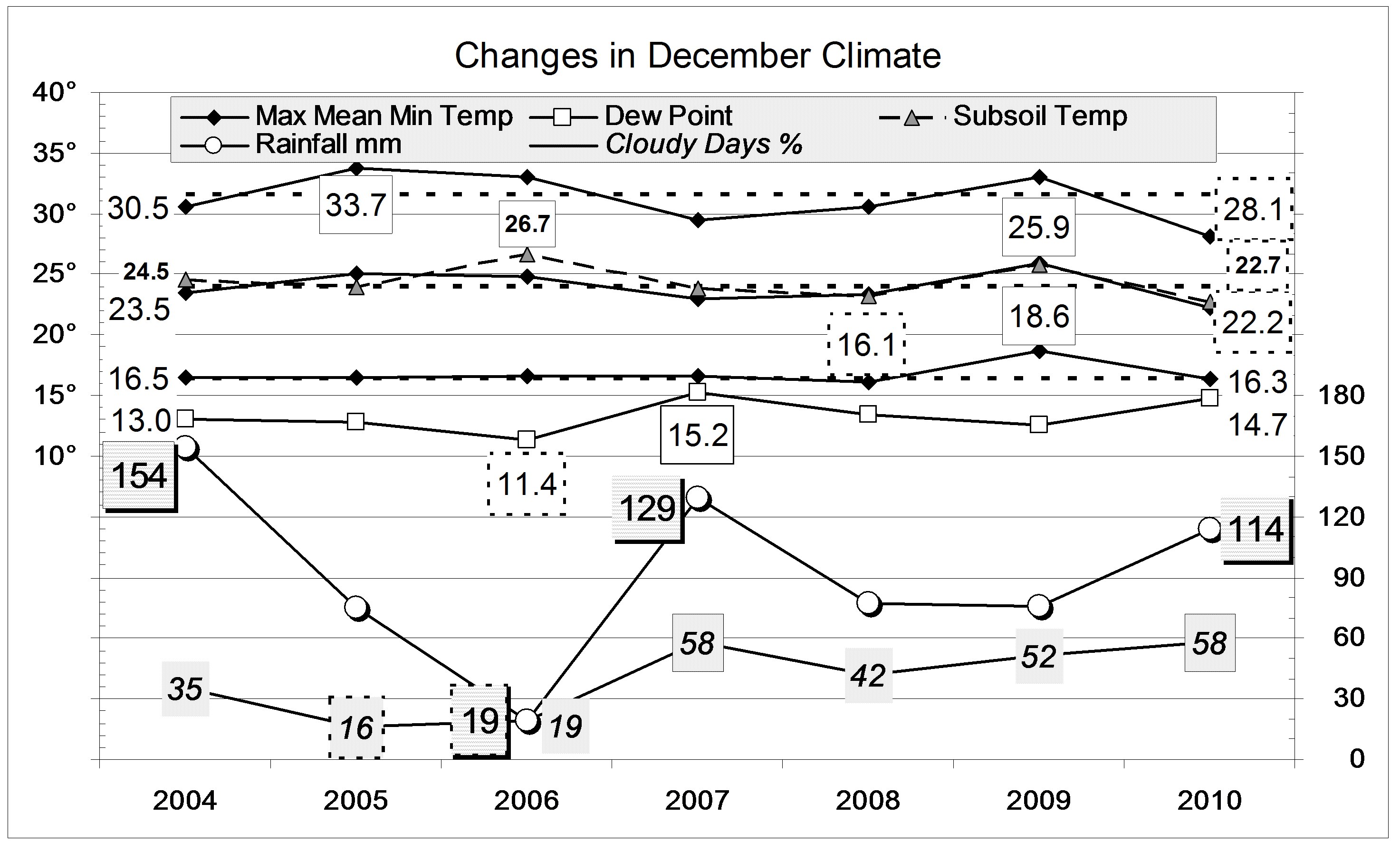
December moved further into the cool, cloudy, humid and wet part of the climate cycle that Dorothea Mackellar called “Flooding Rains”. Nearly all days were cooler than normal, the 19th by as much as 12°. Some nights were also cool, the 21st being 10° below normal.
The highest rainfall reading of 26.4 mm came early in the month. The total of 113.8 mm came in 15 rain days. In 126 years, only six months have had more than 15 rain days. No month ever had more than the 18 rain days of June 1950.

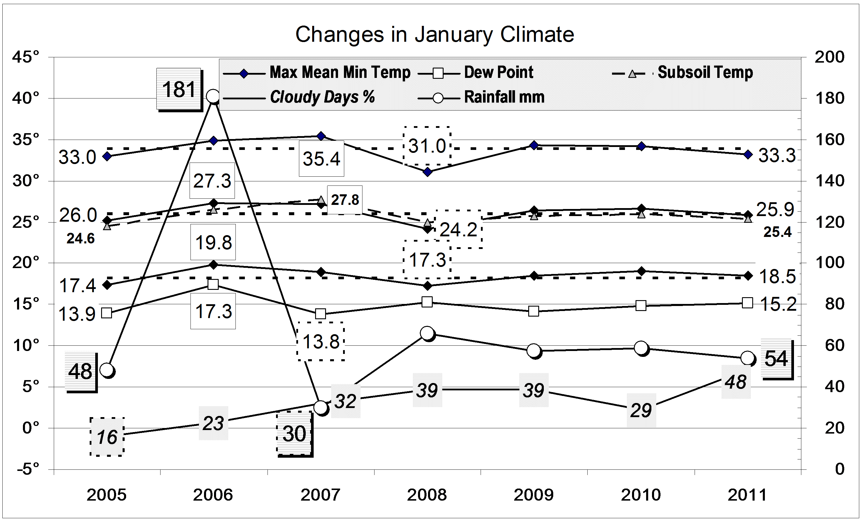
Comparing December months

Climate December 2010

Both the mean daily maximum temperature (28.1°) and the mean daily mean temperature (22.2°) were the lowest for December on this 12-year record. The mean daily temperature range (11.7°) was also a record low value. The mean subsoil temperature (22.7°) was the lowest December value since 1999.
There were 58% cloudy mornings, nearly twice the normal percentage..
The rainfall of 113.8 mm is in the 82nd percentile for December, far above the long-term average of 74 mm. Totals for groups of 2-, 3-, and 4-months are now all above the 90th percentile.

The year 2010

The rainfall for the year was 719 mm. This is well above average, in the 64th percentile, but the years 2004, 2007, and 2008 were just as wet. Most remarkable is that the number of rain days in the year, 112, was the highest ever. The average year has 69 rain days, and the year with the fewest rain days (38) was 1898.
The year was by far the cloudiest in 12 years: half the mornings were cloudy, when normally only one-third of them are. Every month was cloudier than usual.
With the cloud came remarkably even temperatures. Taking average values, the daily maximum temperature (24.6°) was a degree cooler than usual, the daily minimum temperature (11.3°) was a degree warmer than usual, and the daily range of temperature (13.3°) was two degrees narrower than usual.


Data. Rainfall data is from Manilla Post Office, courtesy of Phil Pinch. Temperatures, including subsoil at 750 mm, and other data are from 3 Monash Street, Manilla.

Spring 2010 cloudy, damp and cool

Weather log spring 2010

Days this spring were very cool, keeping the seven-day mean maximum curve below normal nearly all the time. Twenty-two mornings were overcast, twice the usual number, and the number of rain days (29) was the highest in twelve springs.


The mean daily maximum temperature (24.1°) was a record low in this data set, more than 4° lower than last year. Similarly, the daily temperature range (12.9°) was unusually narrow, 3.5° narrower than last year. Other temperatures were near normal, except for the record low Subsoil temperature of 17.5°. Cloudy mornings, at 56%, were a record high.
The total spring rainfall of 249 mm is in the 86th percentile. While this is well above the long-term spring average of 166 mm, four of the previous eleven springs were even wetter: 1999, 2000, 2005, and 2008.
Climate spring 2010

Data. Rainfall data is from Manilla Post Office, courtesy of Phil Pinch. Temperatures, including subsoil at 750 mm, and other data are from 3 Monash Street, Manilla.