Rainfall Shortages up to June 2018

Rainfall shortage Manilla, June 2018

Since the twelve-month drought of 2002, Manilla has been free from extreme rainfall shortage until now. Such a long gap between extreme droughts has not been seen here before. [See Note below: Dry May 2006.]

Rainfall shortages now

On this graph the black line with black squares shows Manilla rainfall shortages at the end of June 2018. Shortages are shown for short terms down to one month, and for long terms up to 360 months (30 years).

[Shortages at the end of May are shown in a previous post.]

[A graph showing shortages at the end of July is in a later post: “Drought Fifth Month; July 2018”.]

Extreme shortages

Three extreme rainfall shortages have now developed, all below the 1st percentile rank:
Total for two months (May and June): 6 mm;
Total for three months (April, May and June): 24 mm;
Total for four months (March, April, May and June): 50 mm.

Severe shortages

There were five severe shortages in rainfall totals as follows:
Total for six months: 141 mm, at the 4th percentile;
Total for twelve months: 350 mm, at the 2nd percentile;
Total for fifteen months: 492 mm, at the 3rd percentile;
Total for sixty months: 2672 mm, at the 4th percentile;
Total for seventy-two months: 3317 mm, at the 4th percentile.

Serious shortages

Some other rainfall shortages were not severe, but serious:
Total for one month: 5.2 mm, at the 7th percentile;
Total for five months: 120 mm, at the 6th percentile;
Total for nine months: 464 mm, at the 10th percentile;
Total for eighteen months: 658 mm, at the 6th percentile.

Comparing June 2018 with the month before

Continue reading

Rainfall Shortages up to May 2018

Rainfall shortage Manilla May 2018

Rainfall shortages now

On this graph the black line with black squares shows Manilla rainfall shortages at the end of May 2018. Shortages are shown for short terms down to one month, and for long terms up to 360 months (30 years).

Extreme shortages

There were no extreme rainfall shortages at this date.

Severe shortages

There were severe shortages in rainfall totals as follows:
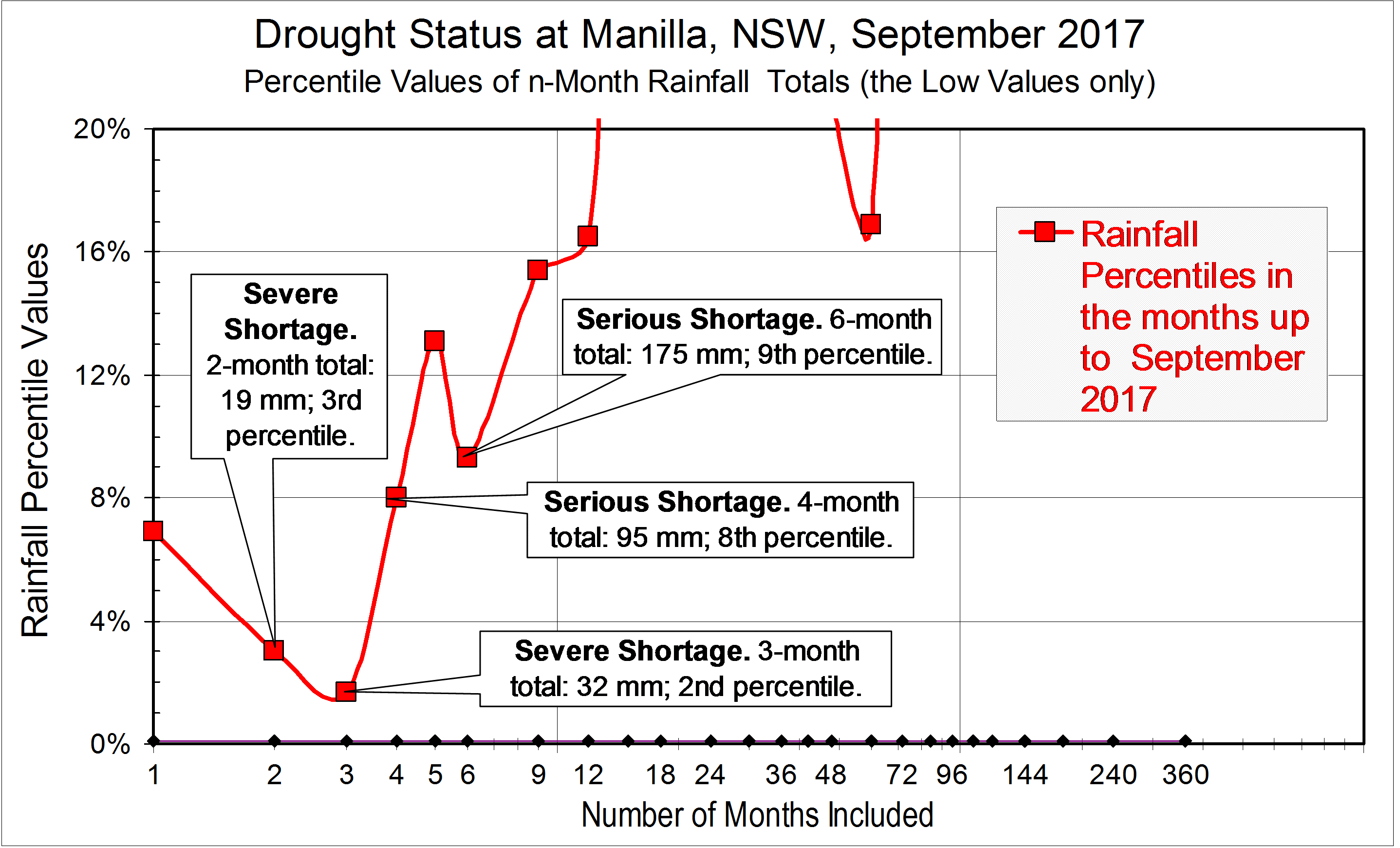
Total for one month (May): 1.2 mm, at the 2nd percentile;
Total for two months (April and May): 19 mm, at the 3rd percentile;
Total for three months (March, April and May): 45 mm, at the 4th percentile.

Serious shortages

Some other rainfall shortages were not severe, but serious:
Total for five months: 136 mm, at the 9th percentile;
Total for twelve months: 408 mm, at the 6th percentile;
Total for sixty months: 2765 mm, at the 8th percentile;
Total for seventy-two months: 3358 mm, at the 6th percentile.

General shortage

The first comment and reply below notes the fact that no rainfall total for any period reaches the 50th percentile. This has not happened for seventy years (1947).

[Later data

The following graph in this series is in the post: “Rainfall Shortages up to June 2018”. For the much worse situation in June 2019, see “June breaks more drought records”. ]

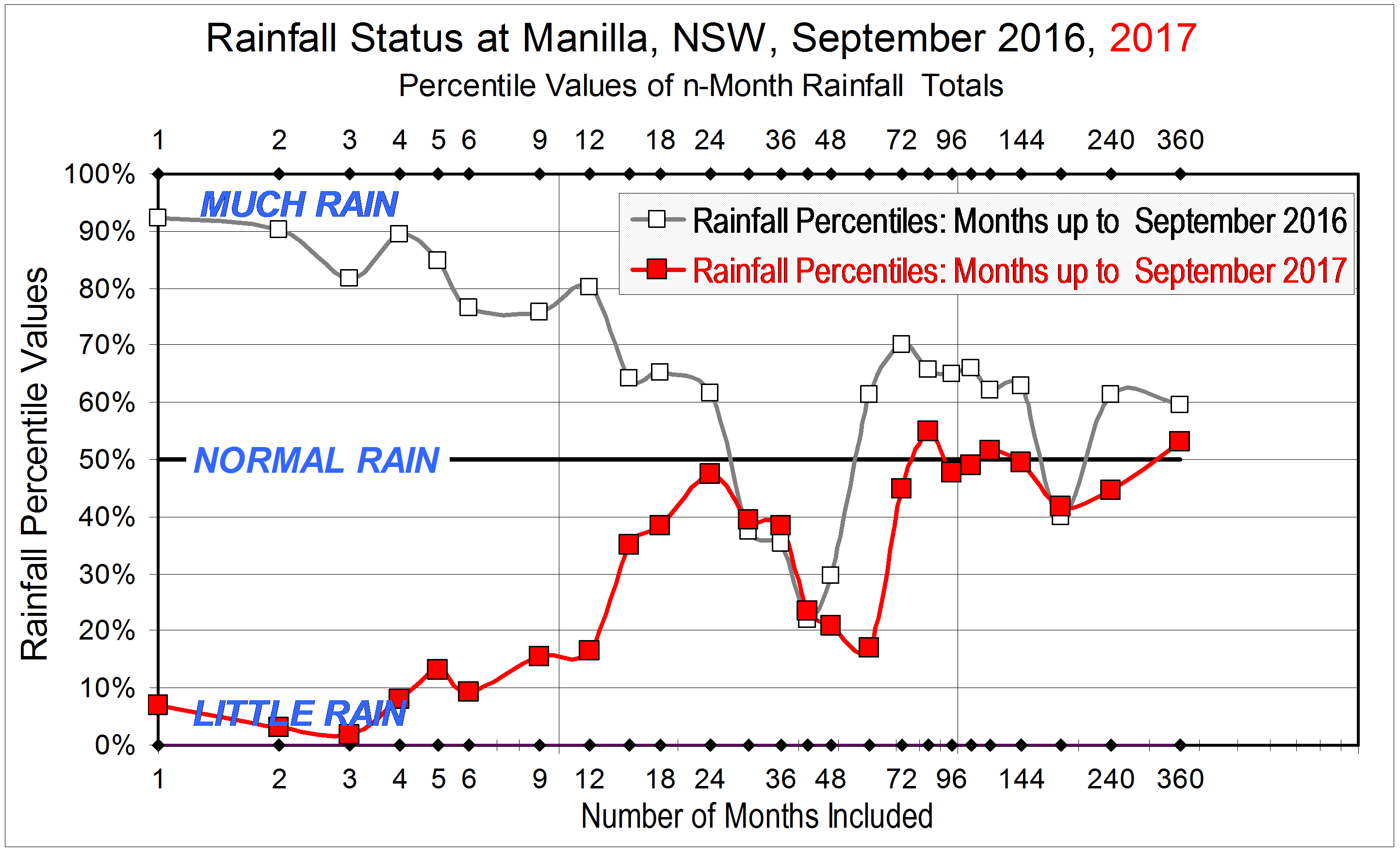
Comparing May 2018 with September 2017

The graph also has a grey line showing similar rainfall shortages at September 2017 (See the earlier post “A drought has begun”.). In the following month, October, there were no rainfall shortages, because the rainfall, 84 mm, was far above average. November, December and February also had rainfalls above average.
Since March 2018, shortages have appeared again. By comparing the black line (May 2018) with the grey line (September 2017), you can see that the rainfall totals are now lower for nearly all periods of time. Only four totals are now higher, including the 4-month total.

What are the classes of rainfall shortage?

We need to compare rainfall shortages. The best way is not by how far below normal the rainfall is, but by how rare it is. That is, not by the percentage of normal rainfall, but by the percentile value. As an example, when the rainfall is at the fifth percentile, that means that only five percent of all such rainfall measurements were lower than that.
Once the percentile values have been worked out for the rainfall record, each new reading can be given its percentile value. Percentile values of low rainfall are classed as extreme, severe, or serious.
For a rainfall shortage to be classed as extreme, its value must be at or below the 1st percentile.
A severe rainfall shortage is one that is below the 5th percentile.
A serious rainfall shortage is one that is below the 10th percentile.
A rainfall shortage that is above the 10th percentile is not counted as serious.

Long-lasting rainfall shortages

Rainfall shortages sometimes last a long time. The same classes of shortage are used for long periods, such as a year, as for short periods, such as a month. They depend on how rare such a shortage is on the average, and they all use the same percentile values to separate extreme, severe, and serious rainfall shortages.

A drought has begun

A year ago, I showed that Manilla was far from being in a drought. That is not true now. There are severe shortages of rain.

Rainfall status at Manilla, September 2016 and September 2017.

The first graph has rainfall totals up the left margin. They are not expressed in millimetres but as percentile values, Along the bottom margin is the number of months included in calculating each rainfall total.

On the graph, I have compared the rainfall situation today, September 2017, plotted in red with that of September 2016, plotted in grey. Much has changed.

Take, for example, the 12-month (one-year) rainfall total. Rainfall totals for 12 month periods are directly above the value “12” at the bottom of the graph, near the label “Number of Months included”. In data for the month of September 2016 (grey), the 12-month total (actually 802 mm) had been at the 80th percentile, which was very high. In up-to-date data for the month of September 2017 (red), the 12-month total (actually 484 mm) is at the 17th percentile, which is very low.
Although rainfall totals for  periods longer than 12 months have not fallen so much, nearly all of them have fallen. Three that have not are those for 30 months, 36 months and 42 months. They were already low, due to including in them some months of low rainfall several years ago, in 2013 and 2014.

So far, real shortages have occurred mainly within the last 12 months. Beyond that, the two-year rainfall total of 1285 mm, for example, is still near normal, plotting at the 48th percentile.

The second graph shows in detail how shortages that are serious or severe have developed during the last six months. These were the monthly rainfall amounts, with the normal amounts in brackets:

April: 24.0 mm (39.3);
May: 55.6 mm (40.3);
June: 62.8 mm (44.3);
July: 13.2 mm (41.4);
August: 13.8 mm (39.5);
September: 5.5 mm (41.2).

As a result, the current situation is as shown below. There are already severe rainfall shortages, at the 2nd or 3rd percentile, in the two-month and three-month totals to date. There are also serious shortages, at the 8th and 9th percentiles, in the four-month and six-month totals to date.

Drought status at Manilla in September 2017

I will update these graphs each month to show how the situation changes.

[Monthly updates were not posted because serious rainfall shortages did not occur in any following months up to March 2018. The next post with a graph and analysis like this one was “Rainfall Shortages up to May 2018” of 15/6/2018.]

[This 2018-19 drought became the worst ever experienced at Manilla. Records for the lowest-ever rainfall totals were broken repeatedly. See, for example (June 2019)  “June breaks more drought records”.]

When is the First Frost?

This year (2017) the first frost at Manilla came on the 11th of May, close to the middle date for it: the 13th of May. In just half of the years, the first frost comes between ANZAC Day (the 25th of April) and the 19th of May.

Graphical record of first frost dates
(See the notes below: “Observing Frosts in Manilla.”)

The date of first frost from year to year

The graph shows the dates of first frosts in the last nineteen years. One feature stands out: from a very early date of the 4th of April in 2008, the dates got later each year to a very late date of the 8th of June in 2014. Otherwise, the dates simply jumped around.

Graphical log of frostsThe date of first frost hardly relates at all to the number of frosts in a season. This graph, copied from an earlier post, shows how poorly they match. The earliest first frost, in 2008, was in a year with a normal number of frosts. In the least frosty year, 2013, the first frost did not come late.

The central date and the spread

To find the central value and the spread of a climate item like this calls for readings for a number of years called a “Normal Period”. (See note below on Climate Normals.) I chose the first eleven years of my readings (1999 to 2009) as my Normal Period. For this period I found these five order statistics:

Lowest (earliest) value: 4th April;
First Quartile value: 25th April (ANZAC Day);
Median (middle) value: 13th May;
Third Quartile value: 19th May;
Highest (latest) value: 24th May.

These five values divide the dates of first frost into four equal groups. For example, the first frost comes before ANZAC Day in one year out of four. This could confirm what Manilla gardeners know already!

Is the first frost getting later?

Talk of global warming leads us to expect the date of first frost to get later. By how much?
Dates on the graph after 2009 seem to be later in the season than during the Normal Period. As shown, a linear trend line fitted to the data points slopes steeply down towards later dates in later years. A curved trend line (a parabola) slopes down even more steeply. However, with so few data points, these trend lines are wild guesses, not to be relied on for forecasting future frosts.
Australian Bureau of Meteorology data for NSW from 1910 shows that daily minimum temperatures have been rising at 0.11° per decade.  (That is much faster than the rate for daily maximum temperatures, which is 0.07° per decade.) To work out how this might affect the date of first frost in Manilla, one needs to know that the daily minimum temperature in this season gets lower each day by 0.15°. One day of seasonal cooling will more than cover a decade of climate warming. The effect of global warming is to make the date of first frost only one day later in fourteen years. If the middle date of first frost was the 13th of May in the Normal Period, centred on 2004, the forecast middle date of first frost next year (2018) would be the 14th of May. This is shown by the flattest of the three trend lines on the graph.

Looking ahead, it seems unlikely that the date of first frost will get later by as much as a week within a lifetime.

[Update 12 August 2019:
This estimate of the median date of first frost, 13 May, is not changed by first frosts observed on 15 May 2018 and 12 May 2019.]


Notes

1. Observing Frost in Manilla

Continue reading

Seasons were strange in 2016

In the year 2016, the seasonal climate cycles at Manilla, NSW were abnormal. Heat and cold, moisture and dryness did not come at the usual times.

Temperature and rainfall graphs

Mean monthly temperature

Graphs of monthly temperatures, normal and 2016The first graph shows the mean temperatures for each calendar month, both in a normal year (red) and in the year 2016 (blue). In 2016. earlier months, such as April, were warmer, and later months, such as October, were cooler. The difference (anomaly) is plotted below. Anomaly values in this year rise and fall rather steadily in a single cycle that lags months behind the normal summer-winter cycle. The amplitude of this anomaly cycle in 2016 is 5.3 degrees, which is nearly one third of the normal summer to winter amplitude of 16.4 degrees.

Monthly total rainfall

Graphs of monthly rainfall totals, normal and 2016In the same format, the second graph shows the rainfall totals for each calendar month, both in a normal year (red) and in the year 2016 (blue). The mid-year months of June, August, and September, usually dry, were very wet in 2016. The anomaly graph adds to this that rainfall was very low in February, March and April, and again in November and December. Rainfall anomaly does not show such a clear cycle as temperature does, but the effect is bigger. The difference in anomaly between September (+80 mm) and November (-40 mm) is 120 mm, while normally the difference between the wettest month (January) and the driest month (April) is only 48 mm.

Climate anomaly graphs and trends for 2016

The other two graphs add more climate anomaly variables and show the trends through the year 2016.
[See Notes below for an explanation.]

Monthly heat anomalies for 2016

Heat anomalies and trends

Continue reading